World Dream Bank
home -
add a dream -
newest -
art gallery -
sampler -
dreams by
title,
subject,
author,
date,
places,
names
CARPENTRY TIPS FOR WORLDMAKERS
by Chris Wayan, 2006
Back to Planetocopia
1: JUGGLING WEASELS
When building a world, I start with a hazy idea--size, heat, wetness, atmosphere, ruggedness. Then comes the math--before a model, before a map, before anything. Math is the bones. Not every detail, but the major features. They must be solid and consistent before I can go on, because they interact. For example, satellites affect tidal drag affects internal heating causes vulcanism affects carbon dioxide affects surface temperature affects water content affects water vapor affects temperature again... on and on. I can't convey the complexity of these feedback loops in words; here's a sketchmap of some of the more obvious factors:
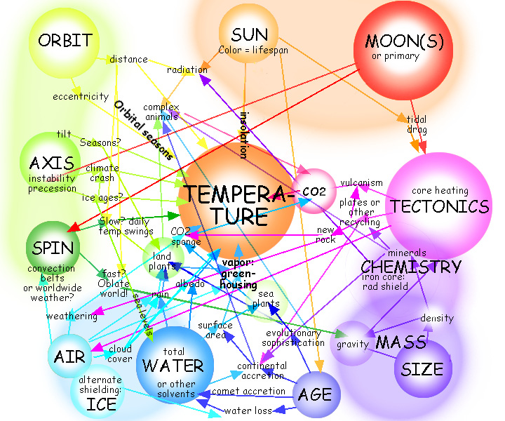
Like the title said: juggling weasels.
The checklist to determine whether a world encourages complex civilization is, paradoxically, much shorter:
- A tolerable temperature range (debatable just what that is)
- Some solid ground (some giant worlds may be global oceans)
- Enough air to allow surface liquids and carry significant rain (is 0.1 atmosphere enough? 0.2?)
- Enough surface liquid (whether water, ammonia, ethane or methane) to generate rain
- A hot enough core for surface tectonics, to circulate minerals and raise highlands (big worlds are hotter, but tidal stress can warm a small world's core)
- Tolerable radiation levels (dense air, magnetic fields and smaller stars), and...
- Enough time (small suns are better)
It sounds very naïve, but they all boil down to these. The devil is in the precursors: the multiple factors leading to these simple things. So the construction process involves lots of adjustments until the numbers look reasonable. Even if no bugs show up, building something as detailed as a world is a long process.
But not a sophisticated one, exactly. You can do it with simple arithmetic, no higher math and not much physics, either: just extrapolate from the figures in any pocket guide to our own planets. Just be careful: each factor affects so many others. Sudoku in space!
2: NINETY PERCENT PERSPIRATION
Here are a few basics for beginning deities:
- SOLAR SYSTEMS
Formulas ahead. But don't panic! This isn't superstring theory. A calculator with a square-root key is all you need. Or a pencil and a brain.
M=your sun's mass, D=distance of planet from sun, Y=length of year, GZ=Goldilocks zone (where worlds get earthlike levels of solar energy)
- A sun's luminosity = M4, its fuel = M, so a sun's lifespan = 1/m3 compared to Sol (10 billion years). This means big stars will rarely have time for their worlds to evolve life; if our sun were even 25% bigger, it'd be dying right about now. 5/4 the mass means 4/5 x 4/5 x 4/5 or barely over half Sol's lifespan! Small stars live practically forever.
- Goldilocks Zone = M2. A dim red star with 1/4 Sol's mass will want Earths only 1/4 x 1/4 = 1/16 as far out! That's only ten or twelve solar diameters away, so the sun will look dim but huge; tidal effects will be equally big and planets will probably tidelock--one face with perpetual day, one with endless night. On the other hand, orange stars of 0.7 M will have a Goldilocks zone half as far out as Earth; tidelocking may not happen.
- Year length
- if distance is constant, Y = 1/M-1/2 (the square root of M) So... quadruple the Sun's mass and Earth would orbit in half a year; shrink the sun to 1/4 its mass and Earth's year becomes twice as long. Go forth, children, and create!
- if solar mass is constant, Y = D1.5. A planet 4 times as far from the sun as Earth will have a year neither 4 nor 42 earth years long, but 8 years: 4 x the square root of 4. Sneaky!
- Gz Y = M2.5. That is, a world in the Goldilocks Zone will probably have a yearlength of M2.5. For a large sun, say 1.33M, the yearlength of an Earthlike world is 1.332.5: 4/3 x 4/3 x square root of 4/3... or about 2 Earth years. (And a sun that big burns fuel so fast life may not have a chance to evolve at all; few living worlds will have years this long! My Lyr orbits in 2.5 years; but it has a very dense greenhousing atmosphere and orbits outside the Goldilocks Zone.) For an orange sun of 0.75 M, a Goldilocks year comes out just under six months long; for a sun of just 1/4 M, it's 1/4 x 1/4 x 1/2, or 1/32 of an Earth year--just 11.4 days! Only there won't be days--just a dayside and a nightside. Roast or freeze? So, again... keep your year reasonable.
- PLANETS
- Mass and gravity
Roughly speaking, your planet's mass = diameter3 (Mars is about half the size of Earth but has about 1/8 the mass: 1/2 cubed), but the surface gravity resembles the diameter (a half-size world has about 0.5 G, etc). "Roughly" means it's only true if the density of your world is Earthlike. A bigger or smaller or absent iron core can affect surface gravity just as much as sheer size. Density's why Saturn, Earth, Uranus, Neptune and Venus all have roughly the same surface gravity, and why Jupiter (318 Earth-masses) still has a surface gravity you could survive... if not enjoy. As with year-length, keep your gravity reasonable--0.5 to 1.5 for Earthlike worlds.
- Spin and day-length
Early in our solar system most worlds probably spun in under 10 hours, but later impacts and tidal drag slowed most of them. Big worlds are hard to slow, but with smaller ones like Earth, chance impacts are a huge factor. We know a Mars-sized object hit Earth, creating the moon; it's dumb luck this didn't kill our spin. Venus was unlucky. It was not slowed by tidal drag from the sun; Earth gets more drag from sun and moon combined (and it was even worse early on; the moon orbited ancient Earth MUCH more closely). Solar drag til the end of time couldn't make Venus spin backward--as it does! No, something hit Venus--hit it just wrong. Even Mercury still spins... slowly. So in general close worlds spin slower, big worlds spin faster, small worlds vary more in spin--but we're theorizing from a tiny sample. Your world hugging its little orange sun closer than Venus doesn't have to be tidelocked. You have wiggle room.
- Sunlight
Sunlight heats a world only as the fourth root! That is, to double the temperature, you need sixteen times the light. (Only got a hand calculator? Find sunlight compared to Earth; hit square root twice to get approximate warmth compared to Earth).
Examples: Earth is ten times closer to the sun than Titan, and gets 100 times as much light; but its absolute temperature is only about 3 times Titan's (square root of the square root of 100). High noon on Mercury hits 675 degrees Kelvin; but high noon in Death Valley, with just one-sixth the sunlight, can reach 325; if noon lasted weeks, as on Mercury, it'd probably top 400. The formula (675°K divided by the fourth root of six) gives about 430°. Anyway, the point is, Martian sunlight didn't doom the place to freeze, and Venusian sunlight didn't boil those seas; greenhousing matters as much as insolation.
- Albedo
Albedo means the amount of light a world reflects vs. what it really absorbs. Cloud cover counts! Venus's are actually not that thick; sunlight at the surface is like Earth on an overcast day. But ice or dense rainclouds can reflect 90% of sunlight, cooling their area around 40% (1 over the fourth root of 10). High clouds and thick icecaps are especially effective since they do the job before sunlight nears sea level; sea ice and low fogs give solar energy a chance to be caught on the rebound.
- Atmosphere
The sky's the limit! Gravity and yearlength of most biospheres are likely to be Earthlike, but the atmospheres of rocky planets vary tremendously. Biospheres could have anything from 1/10 up to 100 times Earth's air pressure, profoundly affecting temperature, climate... and biology. CO2, water vapor and methane are strong greenhouse gasses; nitrogen and oxygen aren't. Earth's atmosphere greenhouses us about 15° C. A thin but cloudy atmosphere (e.g. Titan's) may cause zero greenhousing, or even cool the world a few degrees; to be viable, place such a world at the inner edge of the Goldilocks zone. An air pressure several times Earth's could easily warm a world 40-50° C, so place it well outside the Goldilocks zone! (Exercise: swap Venus and Mars! Might they both be flourishing worlds today?) So if you want thick air to encourage fliers or floating gasbag reefs (or thin air because you're just plain mean) adjust your orbit before designing those cool critters. Broccoli before dessert!
- Climate cells/belts
Planets spinning much like Earth may develop a three-cell system: hot air rises near the equator, causing rain; it cools and drops around 30 north or south, causing dry winds (where winds blow off the land, a desert will form, though a wide stretch of sea can re-humidify this air). Proceeding poleward, climates get wetter again until 60 degrees north/south; beyond is a polar dry zone of cold falling air.
But worlds with faster spins may have more than three convection belts in each hemisphere (consider Jupiter's stripes)...
Slowly turning worlds may have only one cell per hemisphere, rising at the equator and dropping at the pole.
Cloud-covered worlds with dense air, like Venus may have no cells at all in our sense--just one worldwide zone. Makes sense since they're evenly warm.
Ring-shadows along the equator might also create exceptions, such as my model of terraformed Venus with two cells per hemisphere (and warmest around latitude 45, not the equator). But I'm getting exotic. Play with caution!
- Local climates
The key ones to watch for here:
- Deserts on west coasts (if your world spins like Earth) where winds descend--around latitude 30 in a 3-cell model, less in stripier models (Lyr's climate zones are a good example).
- Forests where rising air causes rain: near equator and often around 45-60 latitude in a 3-cell model.
- Continental hearts are often savanna or desert, especially if mountains block storms off the seas. But remember Amazonia! Location matters too.
My personal workflow looks much like the above: I rough out the idea astronomically, then zoom in on the planet's mass, gravity, size, density, atmospheric pressure, total water, approximate temperature, spin, and so on. I need this foundation first.
Next I get physical. I find an old globe, razor off its mountains, gesso it thinly (I like the meridians to show through faintly) and start adding relief. It's white on white still--just a spherical abstract sculpture--and the patterns have to please before I'll go on. When I'm sure of the sea level (which can take a while since more than water content affects it--remember temperature and glaciation), I paint in lakes and oceans, covering them with gloss varnish. Next, I just stare and spin. The globe, I mean. For months. My unconscious is trying to work out all the tangled feedback loops determining climate. Each region depends on all the others (the "butterfly effect") so this is slow.
Only when I'm pretty confident of the overall pattern do I start coloring the land: red desert, green woods, golden prairie, white snow... more months! Takes me nearly an hour per square inch--not the first time, but after you factor in all the repainting as I correct the system. And it always needs correction.
When the globe's done, photograph it before a black backdrop. Correct the contrast, add atmosphere and stars in low-orbital shots.
Oh, and start drawing a world map--it'll be revised a million times, so get started early.
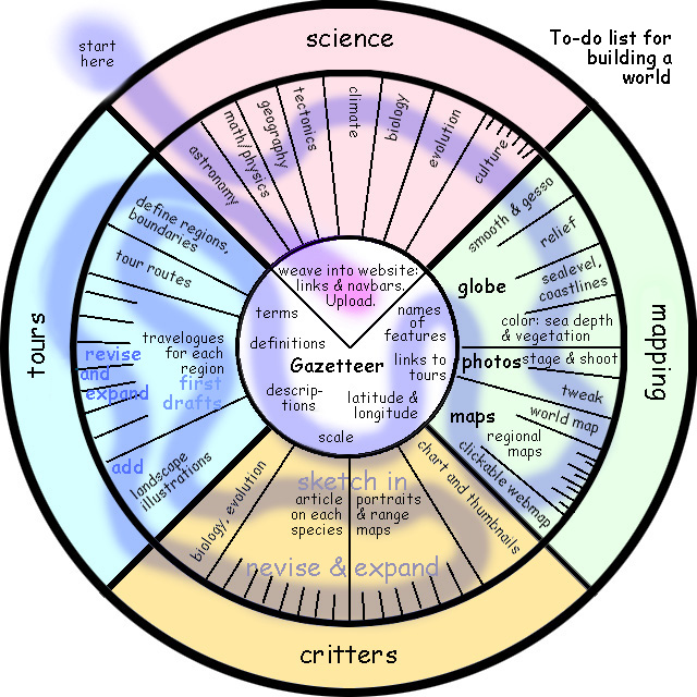
Here's a piechart I use to track in a glance what's completed in the workflow. I've scrawled the approximate order of tasks as I meander through the pie. An intelligent person would rearrange it so tasks are in chronological order, but I never have. Instead it's divided by content:
- SCIENCE: basic facts and numbers; consistency
- MAPPING: physical model; world map; regional maps
- TOURS: safe routes; list of features seen; local maps and orbital photos; sketches of scenery, local people, culture; anecdotes, adventures, travel advisories, plausible chronology
- CREATURES: a chart of all species with thumbnail photos and capsule descriptions leading to full articles on each species with portraits and a range map
- REFERENCE TOOLS (in center): links and navigation bars; names; a gazetteer listing the location, character and size of every named feature; latitude and longitude; scales for the maps; definitions of special terms.
Back to the computer now! Invent some names--planets are big, so you'd better coin hundreds of them. Try it! Not so easy after the first few dozen, is it? And they'd better sound natural--languages that the critters of this new world could pronounce. Now convert these bare lists of names into dictionary entries and links to (not yet written) regional tours. Add latitudes and longitudes and the scale of each feature--height, depth, area... Tedious! But you need to know your world. Write descriptions of each feature. These will be the bones of your tours soon, so get them right. Any unusual terms need defining? Probably.
Next, sit with the globe and figure out how to divide it into regions to tour. On some worlds you have obvious geological or ecological regions, and the only problem is to choose scenic routes that'll link together into a seamless web. But on some desert worlds and sea-worlds, tours aren't easy: you must design flyways, caravan routes or shipping lanes that cover your globe without killing your tourists!
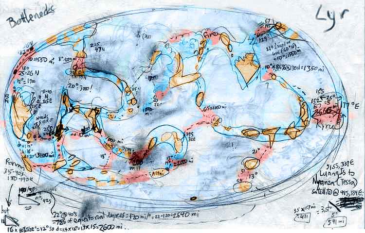 For example, on Lyr (my original sketchmap, above) the natives fly between distant continents along island-chains; but tourists in strap-on wings will lack their endurance. I had to calculate the widest island-gaps and consider prevailing winds to work out what tour routes were even possible without murdering all my readers. You're the guide; it's your job to keep 'em breathing. Sometimes literally. On rugged, thin-aired Tharn, many passes are so high even the locals would asphyxiate...
When you have safe routes, string together the gazetteer entries you wrote until you have a logical narrative sequence describing the ground features along each path. Just an outline now; style and color can wait. Drop in roughs of any orbital photos or maps that you need; and start sketching landscapes where they seem appropriate.
Your world's still empty. Write up a simple evolutionary history--just what sort of place is this? Do you have a sense of who lives here and why? Make a table of creatures, with thumbnail descriptions. As this firms up, you can start drawing portraits. As the info on each species expands, start a page for each one and collect your ideas there. Make a miniature of your world map and clone it into small maps where you can mark the range and origin of each creature. Now write detailed articles on each species, linking them to the table. More portraits? Sure.
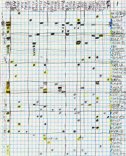
About this time, I make a chart of my illustrations and the (multiple) places they might be used; for example, a portrait of a centauroid might be appropriate in the article on its species but also in a couple of regional tours too. When you'll have dozens of pages and illustrations, such a chart really helps. It's just what databases are for, but I've always just used pencil and paper. Chaque a son gout. Here's a sample from Lyr, with the page-names along one axis and illustrations on the other.
Inevitably, all this time, you'll be expanding and revising those tours as you get to know the locals better, and have more illustrations to add... All these tours need regional maps, too--do you have them? Blow up sections of the world map and add details. I save maps in GIF format despite its limited number of colors; JPG format blurs text, and your names need to be clear.
Keep the file sizes down; not everyone has a fast web connection! No image should be over 100K. So compress JPG images as much as possible (60-80, not 90-100), and limit GIF colors to 16 at most--it'll cut file sizes in half.
Rewriting and adding illustrations can go on for months. But when it feels done at last, test all the links...
PART THREE? I DON'T KNOW FROM PART THREE!
So far I've just described techniques and workflow. Craft, not art.
Now comes the issue of style. But that's so subjective it's hard to address. My last big art projects were deeply personal--the World Dream Bank and the dreambased comics of Dreamtales. I stripped myself naked on those--dreams, whew! Planetocopia is a reaction, I guess--something lighter, more... deniable? Objective, or at least with a mask of scientific plausibility. They're still personal. I build worlds I'd like to live in--pleasant, scenic, furry/multispecies, pacifist, feminist. Your artistic needs may be quite different. My point is, know your biases. Not to repress them--to indulge them! That's what makes your world interesting. Just get the numbers right too; that makes your world convincing. You want both.
I'm still struggling with the issue of presentation-style--even going back and changing earlier planets. The only advice I have is negative:
- High-end animation and intense interactivity are expensive and time-consuming to do right, AND hard to go back and alter as you reconsider, AND you can't possibly compete with the slam-bam seductiveness of games or Hollywood films. So why even try? On the other hand, they're weak on ideas. There, you CAN compete. A cretin could. So focus on text and simple illustrations--they're the most efficient way to convey your ideas.
- Stylistically, obvious is good and humor helps. You're showing complex unfamiliar data; you can't afford sophisticate literary devices like, say, the Unreliable Narrator. Science fiction writers struggle with this all the time, and their rule of thumb is: the more alien the content, the plainer the style... or you start losing readers.
- Bad vibes are common now. Good vibes are rare. Check any science fiction shelf; dystopias outnumber utopias ten to one. Economists tell us rarity creates value. So why not stand out?
Planetocopia, home page for all my biospheres: Tilt!, Futures, the Biosphere Variations, and Caprices
World Dream Bank homepage - Art Gallery - Favorites: Shorts, Great Dreams, Art - On dreamwork - Bibliography
Indexes: Subject - Author - Date - Names - Places - Art media/styles
Titles: A - B - C - D - E - F - G - H - IJ - KL - M - NO - PQ - R - Sa-Sk - Sl-Sz - T - UV - WXYZ
Email: wdreamb@yahoo.com - Catalog of art, books, CDs - Behind the Curtain: FAQs, bio, site map - Kindred sites