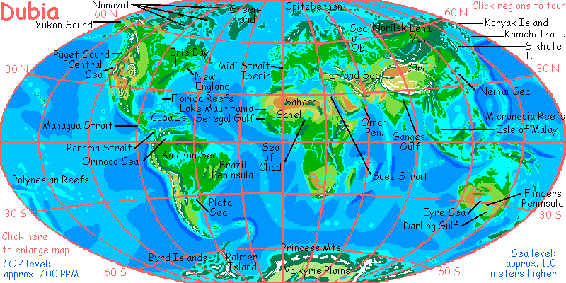
WELCOME TO DUBIA
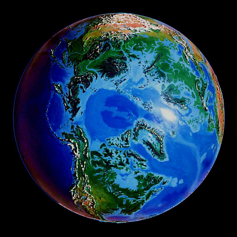
A portrait of a possible Earth one thousand years from now
by Chris Wayan, 2003
THE EXPERIMENT OF DUBIA
WELCOME TO DUBIA
A portrait of a possible Earth one thousand years from now
by Chris Wayan, 2003
THE EXPERIMENT OF DUBIA
Dubia's premise is simple enough in theory. But like most collisions between politics and nature, it gets very messy in practice. Suppose we avoid war, plague, and famine, and the world goes democratic and capitalist? That appears to be the dream of President George W. Bush, or, as he's sometimes known, Dubya.
But part of Dubya's dream is that oil goes on ruling the world for another generation. Despite all conservation attempts, carbon dioxide levels go on soaring. Too many people burning too much fuel! Poor countries industrializing will offset any efficiency-savings in rich countries.
So our grandchildren live in a world with C02 levels double ours, 600-700 ppm. Double ya!
That world heats up. Climate zones move north until the poles thaw. Greenland and Antarctica melt. Coastal nations are drowned. In the end, the sea rises some 110 meters (globally it's only about 75, but as rising seas flood the coasts, they weigh down the continental shelves causing sag and bowing that effectively adds tens of meters in most places to the projections you've seen. The opposite effect is well-known (when icecaps melt, underlying land rises), but neither coastal sag nor the full effect of thermal expansion of seawater are fully considered in, for example, National Geographic's popular article.)
Global hothouse! It's happened before, of course, but not in the last 50 million years or so. Still, that's just 1% of Earth's history! Life has seen this before--recently, even.
But once the catastrophe's happened and the survivors replant, and adjust to redwoods at the poles, and farms in Siberia, and jungles on the prairies, and coral seas where great cities once stood... what if they don't change it back? After all, they may argue, why put the Earth through birth-pains TWICE? Double jeopardy! It's climate change, not climate, that's disrupts communities--both biological and political.
So... they leave the new world alone, to stabilize. We think of global warming in the short range--the shock of change. But what's on the far side? What would that world be like?
I couldn't resist--even though I admit that any climatological projection this long-term and radical is inherently dubious...
Dubia.
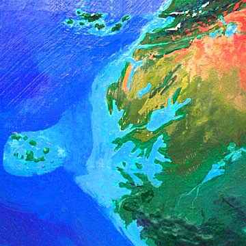
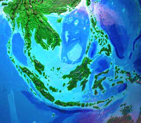
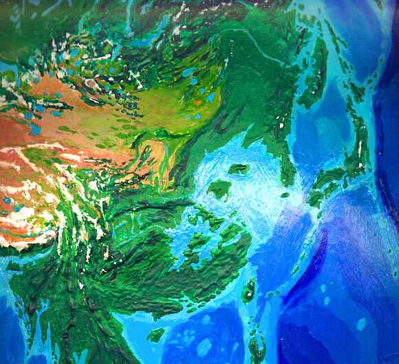
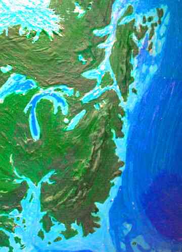
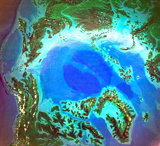
Let's start with a land that once was just a tongue of Asia with cultural pretensions. Now, at last, Europe's a true continent! But a tiny one: Scandinavia, Spain, Brittany and Normandy are now islands, and the northern plain is gone, from Belgium to Murmansk. So are Athens, Venice, London, Brussels, Amsterdam, Hamburg, Copenhagen, Helsinki, St. Petersburg. Other cities like Paris, Rome, Vienna, and Warsaw survive, but are now coastal: their rivers are saltwater sounds or estuaries. Even far-inland cities like Madrid and Moscow are subtly changed--Moscow's just a hundred miles from an arm of the sea.
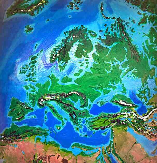
The Gulf Stream sinks in the mid-Atlantic now, overlain by lighter fresh water from the rivers of new-thawed Greenland and North Canada. But a second warm current helps the Gulf Stream keep Europe mild: it circles Europe, north from the twin straits of Gibraltar and Midi (between Spain and France), through the Albion Archipelago (the maze of small islands that were once western France, Ireland and Britain), northeast around Scandinavia and the Isle of Saami through both the Arctic and the Baltic, and south into the new Ob Sea just east of the Ural Range, through the long, narrow Turgay Strait into the Aral Sea, then west to the Caspian and Black Seas, south through the Bosporus and Izmit Straits into the Mediterranean, and west again to close the cycle.
Besides keeping what's left of Europe warm and maritime, this loop's had an unexpected effect on marine life--while the mixing of species caused some extinctions, overall biomass is way up. The inland seas desperately needed this flushing action. The influx of Indian Ocean water from the reinvigorated Red Sea through the Suez Strait also adds species, warmth and nutrients, changing the eastern Mediterranean from a near-desert sea to a rich one. Nile silt, pushed by the twin currents, can't settle in the delta, but forms a long nutrient plume to the west, breaking up into smaller whorls only in the straits south of Sicily. Farming may shift far north in the new Europe, but fishing will move south. And inland, of course.
Way, way inland.
The Mediterranean has grown at the Sahara's expense--not that anyone's crying over it. A 1000-kilometer strip of dry coast, from Alexandria in Egypt west to Bengazi in Libya, is now a long, low island like a huge Crete or Cyprus, whose northern slopes are covered with olive groves. Inland, a chain of oases and sinkholes from Cairo to Libya has flooded, forming a broad but shallow and twisting sound. Its African shore is semidesert, much like the old coast, but up to 300 kilometers further south.
A second, L-shaped sound cuts through Tunisia. Here, too, the vastly enlarged sea with its stronger currents and increased "fetch" for storms, keeps the coast around the sound Mediterranean though hot. The true desert skulks well inland these days, waiting its climatic chance...
Morocco's climate remains Mediterranean, but its southern valleys bordering the old Sahara have permanent streams draining into a string of lakes in the desert, then southwest to the sea. Further south, the coast is scrubland and savanna, broken up by arms of the sea, seasonal lakes and marshes. Inland from the great port of Atar is immense, shallow Lake Mauritania, home to millions of waterbirds. Sahelian grassland cups the lake, not desert.
To the south is Senegal Sound, a vast irregular gulf with wooded shores, drowning Senegal, Gambia, Guinea-Bissau and southern Mauritania, even nibbling at Mali 500 kilometers inland. Beyond, not only the Guinea Highlands but a broad strip of West Africa from Timbuktu to the sea of Chad has reverted to rainforest, since tropical rainstorms now penetrate much further north. The Sahel grassland has also crept inland following the rains: so the very heart of the old Sahara is now a dry-grass steppe, with seasonal streams fed by rain in the now-forested central ranges of Ahaggar, Tibesti and Jebel Marra. Green strips snake down to the Niger, the Nile, and the sea of Chad. Chad is now the largest lake in Africa, possibly the world: in a wet year it rivals the old Caspian Sea.
The West African coast is now as lush as our Congo, though it's broken by two more large gulfs in Ghana and southern Nigeria. The rainforest stretches through Cameroon and the Congo, even south into Angola, though the mountains of Angola and Namibia confine the strengthened tropic storms to the coast and highlands. The Namib Desert now resembles Southern California, with occasional rains and coastal fog, supporting more life, but only intermittent surface streams. Inland, the Kalahari Desert's shrunk to a north-south strip only a few hundred kilometers wide. Ephemeral lakes and mud pans like Etosha are now permanent, fed by streams from the newly forested mountains to the west. The eastern Kalahari is now grassland, broken by a chain of great reedy lakes like Okavango and Makgadigadi. Botswana, Zambia, and Zimbabwe are largely savanna.
The South African plateau is a bit grassier but not profoundly changed, though Cape Town will now have to be renamed Island Town. The rest of the southern coast remains fairly intact, though its famous Californian climate now has summer thunderstorms. Not a full monsoon pattern, but a double rain-peak.

Madagascar is mountainous enough so little was flooded, except the western cape facing Africa; the main change is the resurgence of its inland forests. The lemurs are back.
Zanzibar and its sister isles are gone, but the coastal hills just inland have become new islands much like the old, where cinnamon groves flourish. Inland, across Tanzania and the Great Lakes region, forests have returned to the hills, while the lower plains are farmland and prairie. During the first years of warming, the snows disappeared from Kilimanjaro, Kenya and Ruwenzori, but as equatorial storms increased, they returned to the summits. Northern Kenya is golden grassland; the desert has shrunk to a small patch around Lake Turkana, rainshadowed by the ranges of the Great Rift.
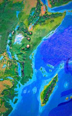
Somalia, once the world's only equatorial desert, has also tipped back into a more stable state: an open monsoon forest on long Shabelle Island and the coast, thinning to savanna inland.
The only surviving desert in the Horn of Africa is the small Afar Triangle in the elbow of the Red Sea. Even the new storms can't reach this rift valley, for jagged mountains block the rain in every direction except the dry north. But its salt flats and stark plains have been drowned by the rising Red Sea, to form a small gulf. Coral reefs grow where salt miners once gasped in searing heat. It's the birth-water of a new continent, East Africa, though full separation is millions of years in the future.
To the north, the Red Sea shores are still desert, although the mountains on both sides are now extensively forested--even the stony heights of Sinai. Sediment from seasonal streams is pushed north by the Suez Current, increasing the fertility of the Red Sea reefs, especially in the north. To the west, the Sudan is savanna and grassland nearly to the Egyptian border.
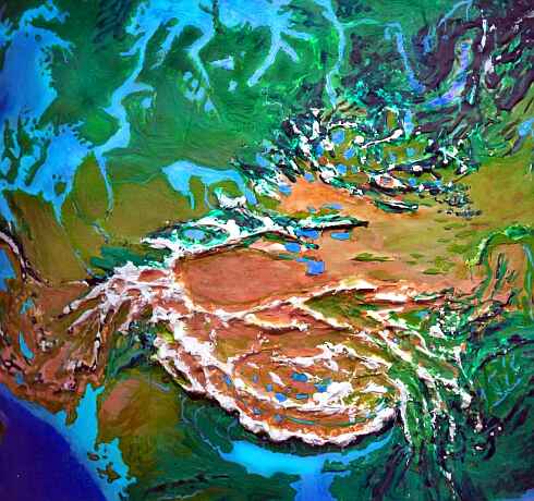
Egypt is still largely desert, but with arms of the sea stretching hundreds of miles into the eastern oases and up the Nile Valley. Cairo's refugees will have to live on the bluffs above--but that's a milder sentence than it sounds, since they're scrub- and grassland now, not full desert. Irrigable strips follow the new streams winding down from the Jebel Marra, breaking up the Western Desert, though its dry inland plateaus are still forbidding.
The Sphinx looks down from its bluff into Nile Sound as calmly as it's looked down on savanna, desert, and city, in the last 6,000 years--awaiting the next change.
To the east, Arabia's desert has been frayed by tropical storms too. The highlands of Yemen and the southern coast are quite green; so's the rugged near-island of Oman at the mouth of the swollen Persian Gulf. The dunes of the Empty Quarter are now partly stabilized by sparse grass fed by runoff from the forested coastal ranges, and seasonal streams wander down the wadis of Central Arabia.
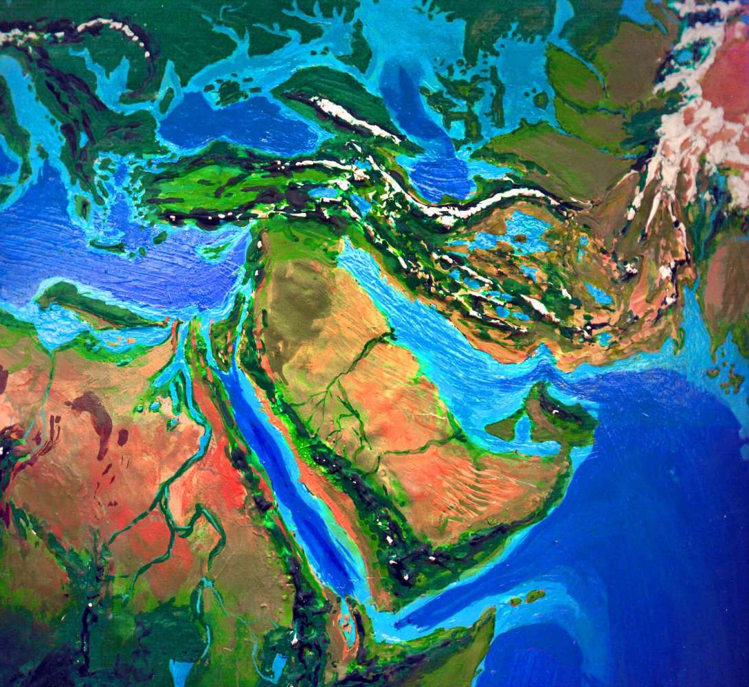
Israel, Palestine, and the Sinai Peninsula are nearly an island, connected to Arabia only at the end of the Gulf of Aqaba near the ancient ruins of Petra. The Dead Sea and most of the Jordan Valley are an arm of the Mediterranean.
The Mediterranean is now just the western arm of the great Inland Sea that covers much of Central Asia. The Black Sea has new breaches to the Mediterranean--east of the Bosporus is Kayali Island, cut off by a new channel at Izmit, while the Dardanelles have a twin strait to the north near Gallipoli.
East of the Black Sea lies Manych Strait to the Caspian Sea. The large ragged triangle is Yergeni Island, with the Rostovs off its western cape and the Caucasus Peninsula to the south. Further east is huge Usturt Island, once a desert between the Caspian and Aral Seas, now a strange maze of mesas and cliff-lined sounds, resembling Greece in size and climate, though without high mountains.
Iran, to the south, between the enlarged Persian Gulf and the Inland Sea, resembles our Turkey--Mediterranean along the shores, dry but irrigable inland, with forested mountains. The mudflats and saltbeds of central and eastern Iran are now great shallow lakes again, bordered by grassland and marsh.
Even southern Afghanistan's old deserts are mostly steppe, though local rainshadows still exist.
Tibet's change is subtle: much of it's like the Andean Altiplano, with cold windy grasslands; trees have crept up into the lower lake basins and canyons. Eastern Tibet in particular, always more hospitable, now holds canyons full of rhododendron and bamboo and pine.

North of Tibet is a land nearly unchanged by the global steambath: the Takla Makan Desert, still bone-dry except at its edges, where the Silk Road runs. The Tien Shan and Altai ranges north of it are greener, though, especially on their western and northern slopes, fed by Inland Sea storms.
India's heartland, the Ganges Plain, is gone. The sea's crept up the Brahmaputra valley, too, nearly to the Chinese border. The new breadbaskets are the green Deccan and what's left of the Indus Valley, where the rains have increased. But even the Thar Desert and Pakistan's dry mountains are grasslands, while the Punjab, straddling the Indo-Paki border, is downright lush. The Rann of Kutch is now a great sound; the coastal hills are an island-chain stretching all the way to Bombay, now a modest island town. Calcutta has, of course, been obliterated.
The nation of Bangladesh is gone too.
So is half Burma. And Thailand. And southern Cambodia and Vietnam...
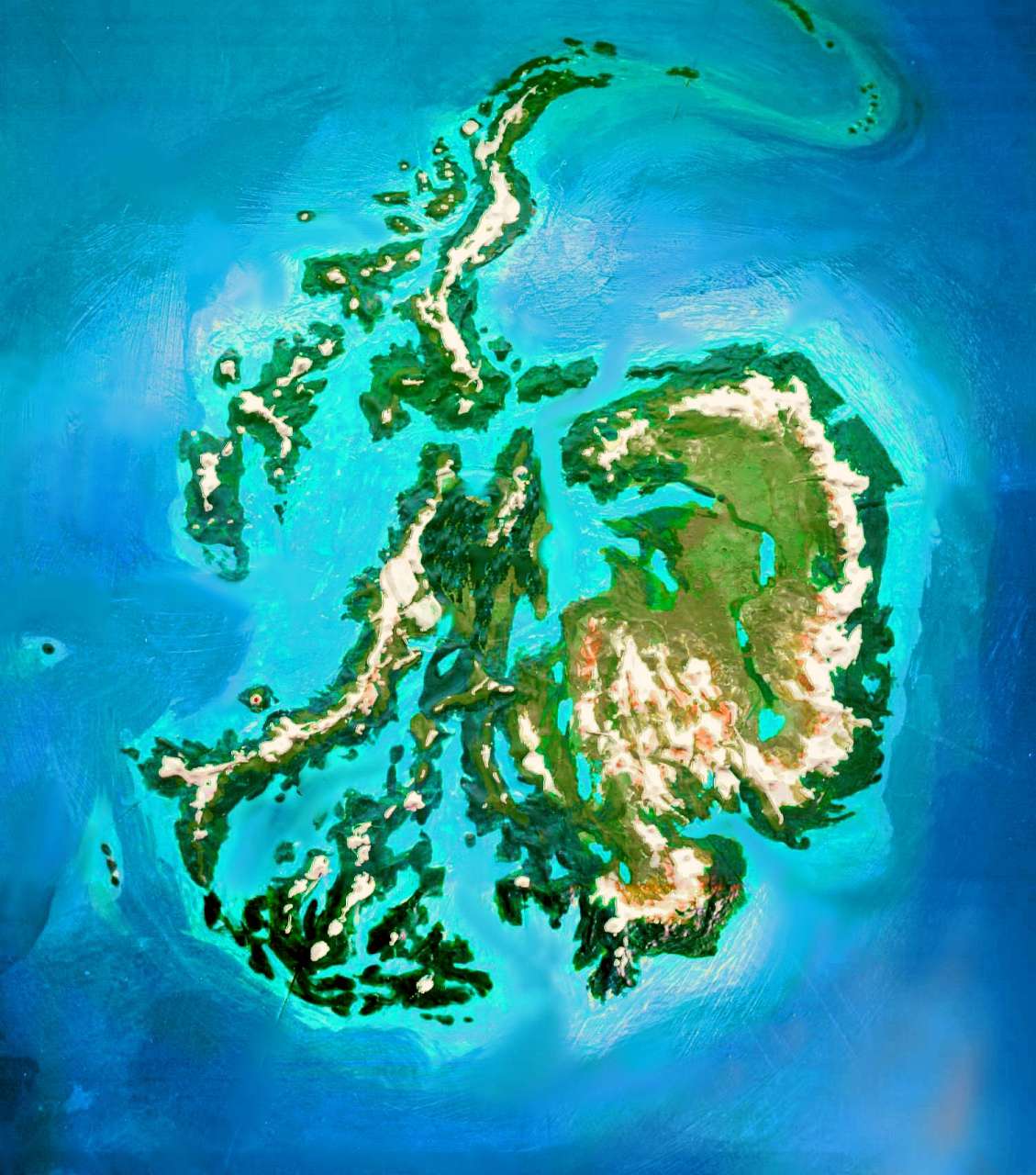
Malaysia is now a wholly offshore nation, like Indonesia. The Malay Peninsula flooded in two places, creating the Isle of Kra in the north and Malaya in the south. Singapore is long abandoned--just another rusty reef. On the other hand, Kuala Lumpur, 40 miles inland in our day, has flourished, though its famous twin towers now rise over the harbor.
Sumatra is still one of the world's great islands, but it looks anorexic--the mountainous spine really shows, for all the fat lowlands are gone. Eastern Indonesia's islands are mostly mountainous enough not to have shrunk drastically, except Borneo. Its southern plains have become gulfs, and the southeast has broken off.
New Guinea, while tectonically part of the Australian plate, is now cut off by a thousand kilometers of shallow sea and seems part of Indonesia. It's shrunk by a full third, and looks like Sumatra or Java--a long, mountainous strip trailing lesser isles east and west.
The tropical ring-current has made all these islands, old and new, even hotter and rainier--reforestation with a vengeance!
Except for the Tuamotu atolls, the South Pacific islands are mostly high enough to survive the rising tides. But the coral atolls prevalent in the equatorial and northern chains--the Carolines, Gilberts, etc.--present me with a riddle. Islands with any hills at all, even a few hundred feet, will end up after the flood with some land or at least shallow water--a seed for the new reef to build outward from. But without knowing the speed of the polar meltdown, it's hard to know how many other reefs would survive. After all, many dead seamounts today were coral reefs in the Ice Age that couldn't keep up with the rising waters when the big thaw came. On the other hand, there are less of these than you'd expect, for a lot of reefs and atolls somehow managed to climb very quickly to survive--despite abruptly warmer water, too. Yet modern reefs are both slow-growing and supposedly devastated by even modest oceanic warming. But our Ice Ages have forced sea levels and temperatures up and down like a yoyo--and the reefs are there. It's a riddle I haven't seen convincingly answered--I can only conclude, for now, that fairly obscure species of "weed" coral only kick in when climate change gets drastic enough--they build up toward the fading sun, until a new stability is reached and more familiar climax-species slowly return to dominance.
So I've shown low islands as new coral atolls, but I've kept existing atolls and reefs, rather than turn them into dead seamounts. I don't know how they change gears and scramble up so fast through rising, warmer water... but somehow they do. Because they have already. Earth has faced a lot of sea-changes lately. We're just the newest.
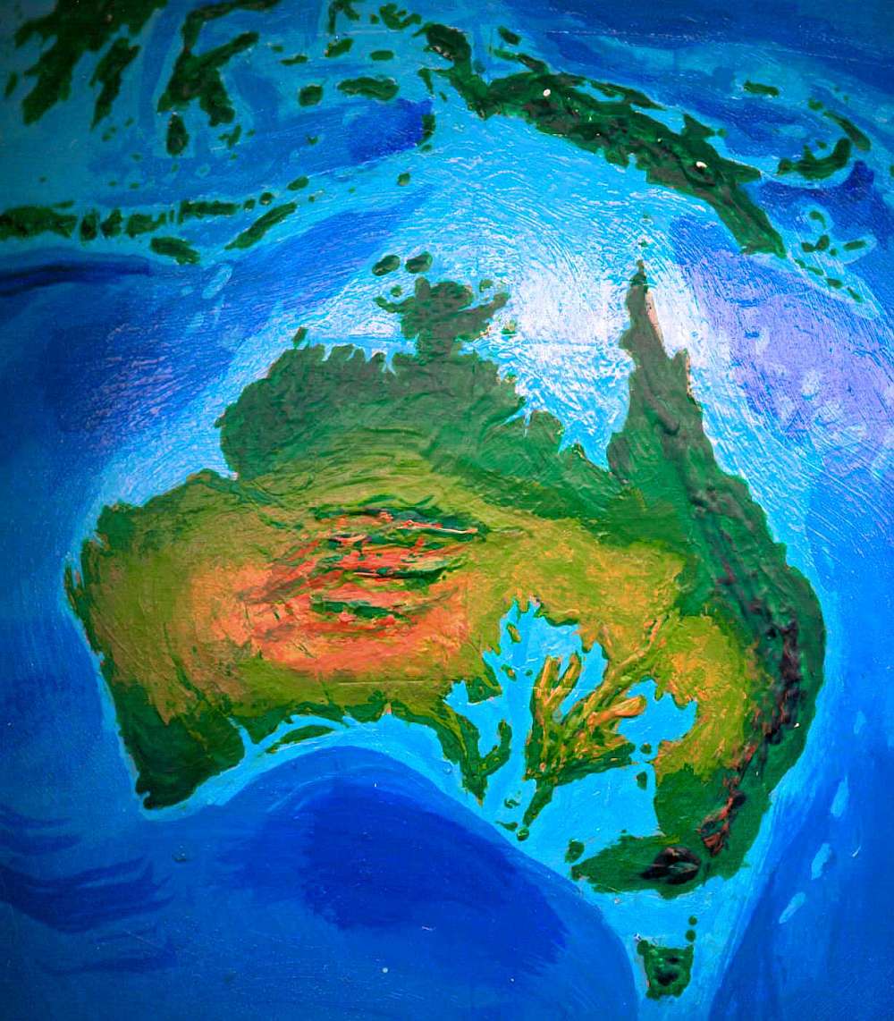
On Dubia, the balance has long since tipped. In the north, the sea advanced up to 300 km inland; the equatorial rains have more than kept pace, penetrating deep inland, greening all Northern Australia. The central mountains catch the last shreds, storing the rains in canyon-lakes. Seasonal streams run from Alice to the sea, winding through rusty savanna and grassland.
Southwest of the mountains is a modest patch of true desert, but the west coast, while still quite dry in places, at least has unbroken ground-cover now, all the way from Darwin to Perth.
The eastern deserts are utterly transformed: the swollen Gulf of Carpenteria and the new inland seas of the south nearly split Australia in two. The Eyre Sea and its eastern twin, the Darling Gulf, create a mini-Mediterranean full of coral reefs. The Flinders Peninsula between them rivals Greece in size and climate, wooded near the sea, brushy further inland. Most streams are seasonal, but the rains never fail now--storms can come from three coasts, north south and east, as in America's heartland.
The east coast is lush; the tropical forest and offshore reefs have crept south from Queensland through New South Wales into the Bass Strait. Even Tasmania's coast harbors new coral reefs. The mountains are, of course, snowless.
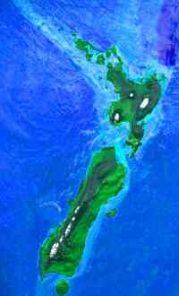
For that, you must head to New Zealand; its higher peaks still sport limited winter snowpacks, especially on South Island (the new population center, now that Auckland and points north are just islets and reefs). Or, of course, if you really like skiing, you could sail due south to the resorts on... but let's not get ahead of ourselves.
Let's start back in Europe again and head due east, this time. The Ural Mountains are now the east coast of Europe. Across the narrow Turgay Strait, with its bridges and barges, beyond the wide, shallow Ob Sea, dotted with piny islets, lies Siberia, huge and fertile--the world's heartland. The Ob Sea's south shore is farmland; southwest are the Steppes--wide prairies, now broken by tree-lined streams and arms of the vast, shallow Inland Sea, which moderates the climate. The Ob Sea still gets an occasional blizzard, but the winters are more Kentucky than Siberia. East of Ob is a land called Norilsk, which indeed resembles Norway, fiords and all. But its pine-clad mountains and lakes are no coastal strip, but the edge of a vast, craggy forest--some two million square kilometers.
To the north are Taymyr and Gabrey Islands, the size of Ireland, snowy in midwinter but covered with forests and farms. To the south are the wooded hills of Tunguska, site of the infamous meteor blast early in the 20th century. A corridor of fields and rolling hills leads east all the way to the great Lena River valley�a gulf now, at its north end. The Lena, notorious in our time for flooding each spring as it thaws, hasn't frozen in centuries.
Northeast of the Lena Valley sprawls Chukhota, a jagged maze of forested mountains, some high enough for snow even in summer. The ranges narrow and the climate turns more maritime, as bays and deep farm-valleys gnaw at the north and south flanks, till Chukhota trails off into the Bering Strait.
To the south is Japan itself, along with the Sakhalin Chain and the huge new island of Sikhote, with New Vladivostok at its southern tip. The islands range from warm-temperate in the north to quite muggy in the south. Aside from engulfing Tokyo, Kobe, and other giant slurbs that in the long run would be little missed, the rising sea has had surprisingly little effect on mountainous Japan except to make the north habitable, while ruining what remained of the rice industry. It's moved to the marshy flats of Australia, Manchuria, the Ob Coast, and Canada.
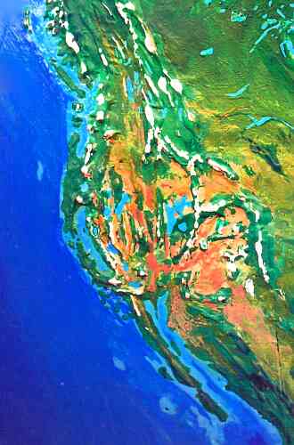
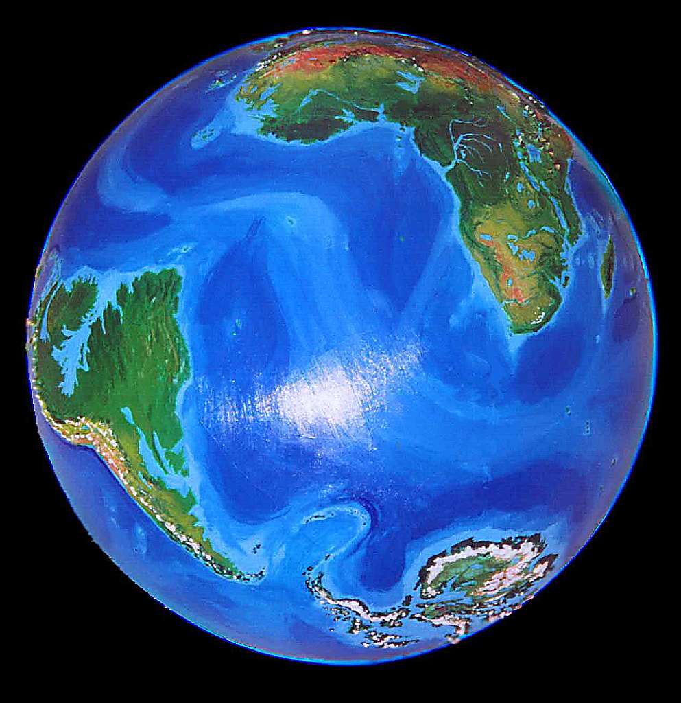
Alaska is fertile, ecologically diverse, and a crossroads for both land and sea trade. Dense redwoods line the coasts, but oaks stud grassy hills inland in the Yukon basin, between the Brooks and Alaska ranges. The savanna corridor leads all the way to Mexico, though much broken up by wooded mountains, canyons, and local rainshadow deserts.
Puget Sound is now an inland passage from central Oregon all the way to Canada; the sea laps at the feet of the Cascade volcanoes. The Central Sea of California has returned, too, bringing coastal fog and mild climate to the Sierra foothills. Coast and Sierra redwoods would grow within shouting distance, except the Sierra species has crept higher and higher up the warming slopes. The populations of the Bay Area and LA did the same: the two megalopoli simply climbed their hills, changing shape, but losing no more than half their populace to the new foothill towns.
Inland, the Bonneville Sea is back, as is huge Lake Lahontan in Nevada and a dozen others in Death Valley, Owens Valley and their neighbors, snaking through a patchwork of prairie, forest, mountain and canyon, greener than our West; more like East Africa at the dawn of man. Early in the warmup, this region suffered catastrophic droughts, but as the sea rose, tropical storms began sweeping up from the Gulf of Mexico and the Sea of Cortez, and a few winter rains off the new Central Sea climbed over the Sierra Nevada, much as sparse rains made it over the old Coast Range from Pacific storms, though they left most of their rain on the western slopes, feeding lush redwood forests. But now the Sierra foothills are redwood country too, and the Nevada deserts resemble the old Central Valley--hot and dry but no longer true desert.
Beyond this lake-basin region rise the Colorado Rockies. Climb them and look down on the plains. Below and to your right is a sea of scrubby trees and brush--a Big Thicket reaching all the way to the Gulf of Mexico. To your left is the southern tip of the great grass sea--it's moved north, into Canada, stretching all the way to the Arctic Sea.
Not that either sea is all that far away.
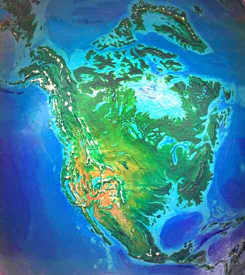
The Arctic Sea's many shallows are rich kelp forests now. Northern Canada's maze of isles and channels is home to many diverse cultures, seeded by the millions of refugees Canada generously let in early in the Great Flood. The mainland was also heavily settled, of course, but integrated more quickly into the new Canadian polyculture. The soil over much of the north was scraped away by the glaciers, of course, requiring much work to rebuild; but with rock, rain, sun and desperation, anything can be done.
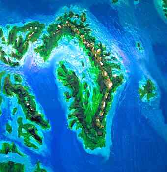
Greenland has changed the most. If you sail west from Iceland your first glimpse could convince you otherwise, for icy peaks still loom above the coasts, especially in the east. But the jagged fjords are lined with dense fir and redwood these days. And inland, over the mountains, is a cool, sheltered gulf, like the old Baltic Sea. The north end still freezes over occasionally in winter, being still water off the northernmost land in the world. But that's all. No bergs, no extensive floes. Greenland and Alaska's modest mountain glaciers are the last traces of the Ice Age in the northern hemisphere. Here inside the Arctic Circle, elk graze and cougars hunt, where ice stood two miles high. Brown bears forage for berries where their white cousins stalked seals on ice. Only a few polar bears transplanted to Antarctica survive--and they haven't thrived even there.
Let's follow that honored American tradition of slighting Canada, and fly south, just glancing out the window at the endless farms and cities of Hudson Bay and Quebec, the East Coast's population center, and instead tour what's left of the United States.
New England's now an island, cut off by the St. Lawrence and the narrow Hudson Straits. I won't dwell on the view from the Hudson Palisades, looking out at the great rust-red towers rising from the sea--it's such a clich�, repeatable all the way from Toronto to Boston to Washington. Instead let's admire Niagara Falls pouring into the sea. No, no, I exaggerate--it's still a good five miles from the beaches of Ontario Sound.
This is Dubia, not Jebbia, and being president means never having to say you're sorry; so we shouldn't be surprised to find that Florida now has no governor--or voters. It's a scuba paradise rivaling Australia's Barrier Reef, but there's no dry land at all. Louisiana was doomed too, of course, but I was startled to find that the sea swallows half Alabama too--south of Tuscaloosa, only Red and Grove Islands and the small Troy Peninsula are left. Mississippi is even worse off--the Gulf chews inland to Tupelo and Mantee, leaving only the Jackson Peninsula and Brookhaven Island, and a jungly strip up at the Tennessee border. Mississippi Bay nibbles all the way up into Illinois, though it's broken up on the west side by long Crowley Island and the Spring and Pleasant Isles. Further south, in Texas, fishermen avoid the rotting, polluted Houston Reefs. But Austin survives--with a steamy coastal climate, flora, and culture resembling lost New Orleans.
Unfortunately, Dallas survives too.
Oh, well--you can't have everything.
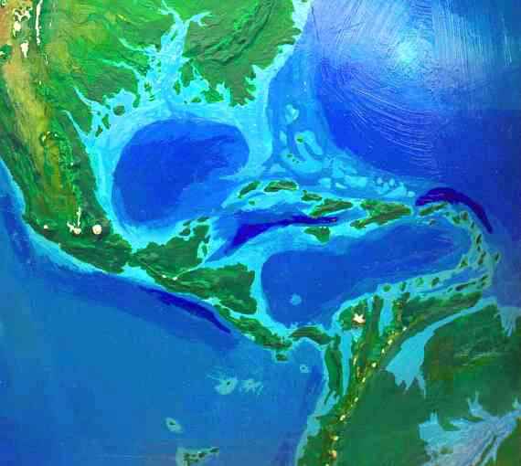
Central America now means something a little different than in our era: two long capes with an island between them, creating two straits between Atlantic and Pacific. The Olmec Peninsula, meaning Mexico below the Isthmus of Tehuantepec plus Guatemala, Belize, El Salvador, Honduras, and northern Nicaragua, ends at the Managua Strait. Beyond it lies the long Isle of Caribbea: southern Nicaragua, Costa Rica, and half of Panama. Caribbea ends at the Panama Strait, where fish swim among the drowned locks and dams. South of it, a ridge snakes through the sea for a thousand kilometers, nearly broached in two more places, before linking at long last to southern Venezuela near Ecuador. This isthmus is called Panama, though most of its spine was coastal Venezuela in our time; the name migrated with the sea. Apparently, Panama's less a place than an idea.
This doesn't mean the Gulf Stream and similar currents will fail--while some Gulf Stream water does divert into the Pacific, just as much new water pours into the Atlantic from the Inland and Red Seas. I'm not sure if the winds driving the current(s) are stronger or weaker. Many models say heating will strengthen winds generally, but Dubia's heat-gradient between tropics and poles is far less. Will trade-winds strengthen or weaken?
A more local effect, but a significant long-term one, is that South American land animals are isolated again. More mammals spread south than north; but now the invasions will end. South America's biota will diverge, inexorably, creeping toward the weirdness of Madagascar and Australia. In a mere thousand years, of course, no one will have noticed yet.
From Panama to Cape Horn, South America's west coast is wetter. In the north, the long Atrato Sound and the new bays around Buenaventura are quite rainy, while the Peruvian coast is scrub and grass with treelined streams. The Atacama Desert is still dry, but resembles Baja or Sonora more than the utterly rainless Marscape of our time.
Looming above, the Andes are greener. Lake Titicaca has grown, and has five huge sisters: Poopo, Coipasa, Uyuni (larger than Titicaca), Atacama, and Arizaro--together some 60,000 square kilometers of water. These and hundreds of smaller lakes moderate the climate of the Altiplano--it's still a cold windy land, but the treeline's crept up and the grass is richer.
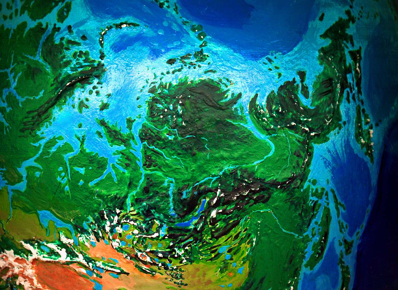
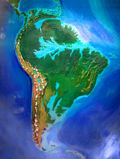
To the east, the Orinoco and Amazon Basins are a steambath--what's left of them. Manaus, once a thousand miles inland, is lost under the huge Amazon Sea, which laps at the Andean foothills on the borders of Peru. One of its islands, long Tapajos, rivals Hispaniola in the Caribbean.
This new Amazonia is an unearthly place reminiscent of early astronomers' speculations about Venus: shallow muddy seas and dense, swampy, multistory rainforest with sequoia-high trees, often flooded at the roots, a land/sea where the sun's face is only glimpsed in flashes, between rains--rains measured in meters, like central Kauai. But instead of that tiny remnant, picture millions of square kilometers. The Carboniferous reborn!
South of the jungles, a transition zone hundreds of kilometers wide is merely Amazonian in our current sense. Even beyond the fringe, drier and opener forest covers nearly the whole continent.
The Brazilian northeast, for example, proves "drier" is a relative term. These warm, wooded hills and valleys no longer suffer droughts, even on the rainshadow sides of the ridges. Fruit plantations replace ranching...
In the south, a third great gulf has swallowed the Plata and Parana valleys. Uruguay is nearly an island.
The pampas are still largely prairie, but trees have crept up the now-permanent streams lining the plains like varicose veins. Lakes and marshes dot the valleys between the Cordoba range and the Andes; the desert here is mostly gone.
Patagonia hasn't shrunk as much as I thought--the plains are mostly above 100 meters. They're still windy and cool, but not as dry--more like the northern American prairies--rich grain and grazing country, in fact.
Off the stormy southern coast (but rarely icy, even in winter), beyond the Malvina reefs, intrepid fishers can follow the long island arc, first east, then south, then west... to the unexpected continent beyond.
The Antarctic Peninsula and the parts of West Antarctica around the Sentinel Range are now a long, twisting island, with glaciated peaks above dense conifer forests. Offshore are broad lower islands in the Weddell Sea. At the south end looms the jagged Sentinel Range, topping out at 5000 meters in Vinson Massif and jagged Mt. Tyree, rising like claws through Alaskan-sized glaciers.
To the east is the Antarctic mainland--a vast grassy plain, drained by the long, winding Valkyrie River, where caribou and buffalo roam in herds the size of nations, swirling around the hybrid mammoths like tides around sea-stacks.
The coastal Princess Ranges ring the plain, forcing dense precipitation to fall on their slopes. This lush, cool forest strip, often less than 100 km wide, endures months of winter darkness, but looks more like Norway or British Columbia than Siberia--the winter freezes are never severe. The rivers teem with salmon, feeding huge grizzly bears, and even the rare Antarctic tiger.
Further east, past the rugged mountains around Amery Bay, the strip widens as the mountains curve inland and spread into a great highland: the Gamburtsev Range. The largest patch of glaciers in the world cling to these peaks, not continuous like Greenland, but a maze of white ridges and green tundra valleys where mammoth and caribou graze: the hundred-eyed Argus Icefield. It's so big, if it melted, the sea might rise one last meter.
Maybe even one and a half.
In the last of these valleys lies long Lake Vostok, open to the air after millions of years under ice. Over the last ridge lies the Aurora Gulf, a million-square-kilometer maze of wooded islands and sounds. Except for the nightless summers and dark, mild, aurora-lit winters, this could be lost Denmark, or Puget Sound reborn. An arm of the mainland a thousand kilometers long divides Aurora from Wilkes Sound, similar except for its spectacular view to the east: the towering Trans Range is a rugged dragon-spine dividing the continent, 4-5 km high. Beyond, smoldering in the Ross Sea, stands Mt Erebus, green-skirted but capped in white ice and black lava flows, 3500 meters high.
Pods of orcas hunt fish and seals in the wide, shallow Ross Sea with its many arms, behind the long, twisting line of the Byrd Islands. Like Erebus and the Trans slopes, they're dark-forested lands of tall cedars and Douglas fir, below glaciers and jagged 3-4000-meter peaks. Siple Island is another peak rising three kilometers abruptly from the sea. This jagged, forested island-maze continues all the way round to the Sentinel Range again. In all, the unflooded parts of Antarctica form a land as large as Australia--two-thirds conifer forest and one-third prairie and tundra and bog. Less than a tenth is ice.
To the north, the green Balleny Islands are stepping-stones to Macquarie and Campbell, and then north to New Zealand or Tasmania.
Astute readers who've explored the alternate Earths of Tilt! will find geographic inconsistencies between my various de-iced Antarcticas--changes not fully accounted for by different sea levels. The soundings available to me, and the uncertainties of ground-level rebound when you remove the heavy ice-burden, left me two choices--to pick one reasonable model for Antarctic landforms, and generate continents from that, based only on sea level and rebound effect...or to create each new version without reference to older ones. I chose the latter--if anything, I tried to emphasize possible variations, while sticking within known parameters. I wanted realism, but also uncertainty. If you saw similar mountains, river-drainages and coastlines, you'd gain a false sense of confidence. And the only confidence I have is that if we had more accurate, detailed data, NONE of these coastlines, ranges or river basins would turn out to be right.
Dubia is more fertile than our world. There are obvious losses--let's start with thirty million square kilometers of lowlands! But the immense new tracts of fertile land in Africa, Australia, and both poles, more than balance this. Some of this land may be used for agriculture, forestry, fishing and so on, but I think it's equally likely these activities will be seen as archaic, barbaric--like ripping up library books for fuel! Our descendants may grow their food, but it's as likely that they'll manufacture it so as to leave the land alone--if they eat at all. We may be silicon-based AIs in far less than 1000 years. The variables here are simply too large to look at, so I've restricted myself to commenting on what "gentleman farmers" might use a land for if they wanted to--more to sketch its character than because I think future people will behave as we do. I doubt that. If they do farm, it may be something far more interesting than food: intelligent life.
Even in our world, with its extinctions and migration barriers, big-brained primates are scattered over a hemisphere--orangutans live in Indonesia. On Dubia, with tropical forest and savanna replacing deserts, primate niches may actually expand. And not only primates. It's worth remembering that (even restricting the field to land animals) elephant brains are as complex as ours, while Arctic wolves have chimp-sized brains, and bears aren't far behind. Parrots and ravens have recently proven to rival apes in intelligence. Dubia, like our present world, has a rich pool of big-brained creatures, the right environment to shape them, and plenty of time. If we let them, they may continue along the path toward culture. In evolutionary terms, after all, a lag of a few million years is nothing--a few steps behind us on the path!
Or, of course, our descendents may turn interventionist and push things along. An ethical case can be made that creatures forced to share the costs of our civilization (let's start with hunting, pollution, habitat destruction, and a simple sense of dispossession and bewilderment as their world turns surreal and nightmarish) have a right to the benefits, too: health, hands, language, culture, knowledge, leisure time, and most important of all, a voice in the direction civilization takes.
Either way, my guess is that even the contenders who start out herbivorous may become omnivores soon after they developed fire and tools. Big brains burn a lot of fuel, and fat and protein are such concentrated food sources! The crucial difference between such people and us might not be diet or shape or ancestry, but temperament. Aggression, territoriality, sociability, gender differentiation? And subtler traits: socially adept like bonobos, or clever but introverted engineers like orangutans? The dominant sense may be sight, smell, touch or hearing. Such species differences will shape animal cultures profoundly. Look how we take our tool-dexterity, our intraspecies aggression, our constant sexuality, and our smell-blindness for granted! The evolution (aided or not) of other intelligent species will answer questions we're now too parochial to frame.
Here I'll explore the regional effects of climate change, then deny everything and explain why, backing off for a global view.
Our world's still dominated by the temperate zones, which have imposed their cultural values (needed to survive a snowy winter) on peoples of the deserts, jungles, mountains, islands and tundras, whether or not they're appropriate. By any measure, civilization's center of gravity is slipping tropicward. But there are tropics and tropics. The timeless tropics are a colonial fantasy justifying rule of all those lazy brown people needing guidance. In fact, monsoon climates require strong annual planning, and seasonal rituals to anchor one in the annual rhythm. The Dubian world will have vast new monsoon regions like Australia, Arabia, and Sahara.
But the rhythm we'd find alien on much of Dubia is something else entirely: the day. Life hasn't had to adapt to a temperate polar climate in fifty million years! Months of cool semi-darkness, lit by moon and stars and brilliant auroras and dawns that never see sunrise. Then months of light--a low sun circling the horizon, but unlike our polar summers, genuinely warm...
The Inuit culture is polar, and is adapted to this extraordinary light pattern, but also to constant cold, barren, treacherous land, uncertain hunting, and large predators--a deadly world demanding solidarity and skill. I don't think these threads can be untangled--the mild, rich polar lands of Dubia will foster a very different kind of person with annual life-rhythms unlike ours. Polar cultures will be fascinatingly unlike anything we know.
The vastly increased fertility of Australia will also have cultural effects. In our world, Australia wasn't just held back by isolation; the total population was low and mostly poor; there was room for few innovators. On the eve of European invasion, Australia had only 300,000 people. Much smaller New Guinea had well over a million! But on Dubia, Australia is rich and fertile; the continent will be a cultural heavyweight at least on a par with China or Siberia.
I've been talking regions, and ignoring the two great global changes that will shape the future. One is technological change--but we can't predict that on a thousand-year scale except to say that Vernor Vinge's prediction of a technological singularity is extremely likely. One can argue that his schedule, saying change will accelerate to an inherently unpredictable cusp (whether paradise, apocalypse, or both at once) within our lifetimes, is too quick. But in a thousand years, I think it's clear that people will be unrecognizable, if people in our sense exist at all.
Still, this is a caveat that applies to absolutely any future longer than fifty years. Dubia's a specific experiment, so I'm arbitrarily postulating that one or more branches of intelligent life will remain in its home niche, Earth, and could be called, loosely, people, filling an analogous ecological role, as caretakers (or meddlers).
A technological singularity of some sort is one global certainty. The other is the eco-catastrophe's shadow.
Catastrophes change societies. If you drown your own cities, it's hard to blame God or chance--it's too clear your society is destructive and has to change. The culture of the future, whether it's human or multispecies or silicon, will take it for granted that it's the custodian of the planet's health. That requires thinking in such long terms that our notions of wealth, class, power and status will be irrelevant--or at least thoroughly rebuilt.
The dilemma our cultural descendants must solve is: can we evolve cultural controls and outlets so we can safely exercise animal-needs like competition, dominance behavior, and territoriality? Or are these traits so incompatible with our new job as planetary custodian that we must engineer ourselves into another, calmer species? Our current social structures--warlordism, state socialism, and capitalist democracy or oligarchy--serve the needs of one species only, and usually just the short-term benefits of a small minority of that species. None, and I emphatically include capitalist democracy, are viable in the long run. Maybe anarchist cooperatives could manage the long view... I don't know. But even a mere thousand-year hop in time will show an Earth without one of two things: business as usual, or life. They just aren't compatible.
End of sermon.
Does Dubia look too damn nice? Unrealistic? You came here to see the consequences of our current ecological irresponsibility... So here's Dubia, the worst-case poster child for global warming, and I've painted it as livable, even pleasant. An oil company must have funded me, right?
Nope. There's a hidden factor making well-informed readers expect the worst from any catastrophically changed world--not just Dubia.
"The grass always looks greener on the other side of the fence." That old proverb isn't about jealousy, as most people think. It's subtler than that. You see, it's literally true. When you look at grass you stand on, you're looking down--you see the leaves end-on, so a lot of bare earth is visible too. When you look over the fence at your neighbor's grass, you see it full-length, at a low angle, so the grass-blades overlap and hide the ground. Even if your lawns are identical, your neighbor's grass really does look greener.
And this effect crops up in other places. Ever notice, on a large busy road, how you always get stuck in the slowest lane? Lady Luck isn't out to get you--by definition the most crowded lane will have the most people in it! Clear, fast-moving lanes have fewer drivers. More often than not, you really ARE in a worse-than-average lane. The grass is greener in the other lanes--till you move over, and slow them up!
This principle applies to alternate earths--but in reverse.
Let's contemplate Randomia, an Earth no better or worse than ours, with roughly the same biomass, same amount of arable land, about the same population... just re-distributed. Deserts are fertile, farmland is desert. Now, what regions will you notice the most? First, your home, of course, and then, other well-known regions--and well-known means inhabited.

Randomia will always look inferior! For, by definition, most readers will be from our world's high-population zones. Random changes will, on average, degrade them. And the lands that improve, that become the heartlands of Randomia's civilizations, are likely to be barren obscure lands in our world, mere names (if that) to non-Randomian readers. The great European cities are all flooded on Dubia (millions of European readers groan), while the green Sahara nurtures great civilizations (a handful of Saharan readers cheer). If you love civilization, Randomia will probably kill or cripple the ones you love, and plant its greatest civilizations in places you associate with backwardness.
So the grass always looks browner in a parallel world--because what you value most, what you KNOW to value, is generally lost. This principle makes it hard to see alternate worlds fairly.
So, if I seem foolishly optimistic about the alternate Earths I build, postulating island leagues and tropical civilizations and oases in Martian deserts and islands in the Great Flood and seal-holes in the Global Icecube, if I postulate intelligent lemurs or elephants or mega-ravens... just remember I'm fighting the Randomian factor. Your view is colored by the degradation of what you know and love; so my predictions of new growth in unlikely regions and species, will seem fatuous. Yet they grow from the same changes as the doom and gloom--your perceptions are naturally tilted toward seeing the losses.
Factor Randomia in, before you mock.
The problems Dubia poses were unexpected. I'm personally appalled by Americans' energy-waste; to me it borders on the criminal. But while researching the climatic extremes I had to, to prepare this model, I grew aware of the great flexibility of life as a system--and, especially, its exuberant response to increased warmth and rain. Biologically, Dubia works just fine. It's the transition that's problematic, and that's mainly due to our human propensity to build coastal cultures. We pay a price for that mild sea air. Sea levels change and coasts move--humans or not! This is, after all, an interglacial. In the long run, if it wasn't a human-caused flood, it'd be a nature-caused ice age. Abrupt climate change is a simple fact in our current geological era. So regardless of future environmental policies, I predict a growth industry will be the excavation of cultural icons just ahead of floodwaters, and their relocation inland. Diking and doming? Maybe. But our descendents may, in a subtle way, all be nomads--home may mean, not a place, but a climate, a biological community, and a society celebrating those patterns. Moving New York to the Isle of Adirondack, or to North Greenland, in search of a similar setting and climate, may be more natural to them than preserving things on site.
Sorry, got distracted there. I just meant to explain that when building a truly alternate Earth, as in the TILT! series, I never felt any guilt. Flooding, freezing, boiling, drenching, drying... so what? The places I was postulating would have always been that way. No refugees, no grief.
But Dubia projects our real future--one of them, at least. As I wiped out a fifth of the Earth's landmass, I couldn't help thinking, guiltily, of the people I was evicting. Would they die? Where could they go? On a species level there's no question we're to blame here, and I even felt a certain righteous glee as I drowned all the First World's industrial heartlands. But on a regional and individual level there are several billion victims, mostly too poor to be serious greenhousers. For the first time in my career as a world-builder, I was a world-destroyer too! And handling such projections intellectually didn't mean I could handle them emotionally.
A second problem was simply the level of detail I went to. This globe is vastly more accurate than its predecessors in the TILT! projects--indeed I went back and altered a few glaring errors revealed during my research. I consulted much more detailed maps and climatology books, and more of them--learning, in the process just how much conflict there was between supposedly authoritative sources--even about basic topographic facts! For this globe, more than any other, I learned Earth's present geography in painful detail. No, that's a lie. Not painful--the word is addictive. I spent days just staring at maps in a trance, hovering condorlike over every land on Earth. I learned unexpected things. For example:
The third great Dubian challenge for me involved currents and heat circulation. Wherever I can, I work by analogy, not theory or calculation, looking for similar latitudes and landforms and currents, figuring nature knows better than our simulations. But our current world can't test every possible configuration, and Dubia's an odd case. It allows an equatorial current to circle the Earth--but not as freely as 50 million years ago. Panama was breached only a few million years back, but Dubia's ring-current couldn't develop: it was still blocked by Suez, and Malaya. Nor were CO2 levels high. When CO2 skyrockets, especially when a hot ring-current flows unimpeded, the tropics have usually become what I've described here. But large east-west barriers remain, and most water is still going to circulate into the temperate zones, in traditional whorls--plus some new ones, like the current circling Europe. It's a mixed situation, and I saw nothing to convince me the Hadley cells would change much (the worldwide convection loops in the tropics, the temperate zones, and the polar regions, with boundaries around 30 and 60 degrees). This is why I haven't generally let deserts advance north with the heatwave, as many models do--I think rain-patterns cling more closely to the Hadley cells, and in any case there's more sea to moisten the air now in these boundary zones.
The point is, I'm undoubtedly wrong--every climatologist is. But how much, where, in what directions? I'm sure the Great Flood carves up the continents--but beyond that?
NEXT!
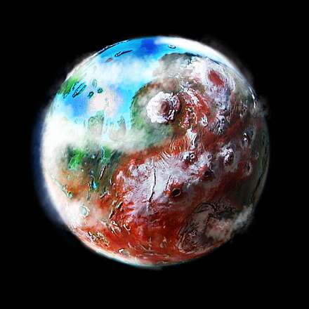
I seem to have finished TILT!, my game of tilt-the-axis-and-see-what-happens. Instead, I'm going ahead with Futures--snapshots of worlds on the same day 1000 years from now. What worlds? Earth, Mars and Venus, I think. In a thousand years, I expect terraforming to have transformed both--though I may regret budgeting a mere millennium when I get to Venus. She may be a stubborn girl, given her sunburn and spin problems--not to mention CO2! But I'll give them both my best shot--in the case of Venus, a lot of shots: artificial comet-strikes bringing ice from Jupiter or Saturn's moons. I'm calculating how much rotational energy they'll add, as well as water, though the results look dismal so far.
Well, no one said Venus would be easy. But think about it. You do Mars, and after a lousy billion years it'll all leak away, and you're right back in dustville. But Venus is like hardwood. Tougher to work with, but what you build will really last. Earth's twin sister, but because she's the quiet, modest one under the veil, she gets no notice--no respect. Her bratty little brother with the red pimply face gets all the attention...
Still, because everyone expects it, and you have to give even bratty little brothers their due... I'll do Mars. First, even. Venus, after all, is more complex and uncertain. How exactly to go about it? But Mars is a natural for terraformers--like a primer!
I wonder if it could have been set there? For that purpose?
Just an elementary class assignment. Nice little world, kids--if you can build it.
World Dream Bank homepage - Art gallery - New stuff - Introductory sampler, best dreams, best art - On dreamwork - Books
Indexes: Subject - Author - Date - Names - Places - Art media/styles
Titles: A - B - C - D - E - F - G - H - IJ - KL - M - NO - PQ - R - Sa-Sk - Sl-Sz - T - UV - WXYZ
Email: wdreamb@yahoo.com - Catalog of art, books, CDs - Behind the Curtain: FAQs, bio, site map - Kindred sites