 The Malawi Islands
for Jane Goodall
by Chris Wayan, 2020
more planets: Planetocopia
Inversia homepage - (not done, don't click:) geography & climate - evolution - peoples - map & tours
The Malawi Islands
for Jane Goodall
by Chris Wayan, 2020
more planets: Planetocopia
Inversia homepage - (not done, don't click:) geography & climate - evolution - peoples - map & tours
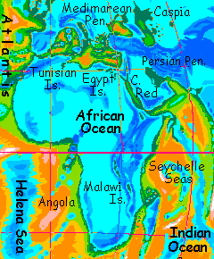
Introduction - Tanganyika Islands - Malawi - Biology
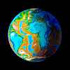
This tour covers all the islands in the African Ocean except those in the far north (covered in the tour of Medimarea, the Inversian equivalent of the Mediterranean Basin). The African Ocean is big (for Inversia), over 25 million square km (over 10M sq mi), so it's startling to find only four islands of any size. All rise from deep water along the East African Rift...
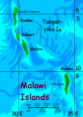
Earth's Lake Tanganyika is a Rift Valley lake, long, narrow and deep--so deep that although the lake is over 770 meters up (2500'), its bed dips below sea level in three long stretches. On Inversia, these form the Tanganyika Chain--three long ridgy islands. North to south:
Gombe
Over 200 km long but less than 50 wide (125 by 30 mi), Gombe is mostly smooth sweeping slopes up to central ridges highest in the southwest--still just 250 meters (800'). Hot and muggy half the time, hurricane-lashed the rest. Annual rainfall? 15 meters, topping out in the southwest hills at over 20 (Earth's record, in Kauai's upland, is about 11--over an inch a day, every day). Why? Gombe's just 5° south, and deep in a sunken basin 10°C (18°F!) hotter than OUR equatorial sea. Not even rainforest--stormforest. For humans it's a sauna--fatal for many, unbearable for all. If you tour, you'll spend so much time in the water cooling off (evaporation won't work in this steambath) you may just wrinkle to death.
There are tribes of gliderchimps in the canopy, though; with body temperatures of 50°C (122°F) they're well adapted for the heat. They look like a blend of Earth's flying foxes and chimps. They're capable of (very short) true flights; the air in this deep basin is so dense, 1.6 atmospheres, that it doesn't take much wing area to support your weight.
Supercharged by all that oxygen, gliderchimps are smart, too. Animals or people? They use tools, weave simple shelters, and have a 200-word language. Their colonies are legally protected; it'll be interesting to see if, in another fifty thousand years, they join the confederation of other flying mammals and large birds that dominate the Oceanic Basins.
Mahari
The middle island, Mahari, is smaller--140 by 32 km at the widest (85 x 20 mi). It's lower too--just a rolling whaleback of stormforest. Just as hot and steamy.
Moliro
The southern island, Moliro, is big--just as big as Gombe, and with higher hills, up to 700 m (2300') along the western shore. That's tall enough to cast a significant rainshadow, so a narrow coastal strip, just a few miles wide, is... still forest, still wet, but opener and less humid; barely fatal! If you MUST visit the Tanganyikas, land here. You might actually survive.
No gliderchimps though. They're unique to Gombe. They can fly a few hundred meters in a pinch, but it's long (and stormy) miles between islands; you need boats, not mere rafts. So far, gliderchimps haven't mastered them. On the other hand, or wing, or paw, that means Moliro's not restricted; ports full of bigger, smarter, more fascinating creatures... and these species are definitely people worth talking to. But they're not rare. Why not meet them high on the slopes of the African Basin instead? It's cooler.
Intro - Tanganyika Islands - Malawi - Biology
Malawi is a single island southeast of the Tanganyikas; it's the equivalent of the north end of our Lake Malawi, where the lakebed is deep enough to dip under sea level. It's a hair larger than any of the Tanganyikas, some 225 by 50 km (140 by 30 mi), but solitary. Because it's farther from the equator, Malawi is drier, with a monsoon climate; summer typhoons but just sparse winter rains. Never a true drought--this is the African Ocean! But still, Malawi's west coast has open forest. Views. Breezes. And it's not, in winter, quite so hot--just 35-40°C, with almost-bearable humidity.
This microclimate is paradise for the locals; they've built a major port here. Not just a sea port; shipping is minor on Inversia. Too slow for fliers. No, it's mainly an airport. With no planes, metal detectors or waiting in line. Just... you fly in, on your own wings, and rest up, and get the news from all over, and play, and then, refreshed, fly out. Simple. So Westport is a happy place. And, as I say, around August, in the depths of local winter, one you can appreciate. And come home, uncooked, to say you were there.
Intro - Tanganyika Islands - Malawi - Biology
This little stub will eventually expand a lot as I work out what the natives of the sea-basins are like. The most important thing is: they'll probably fly. The dense air makes it easier for climbers to glide and gliders to evolve to true flight. Way less wing surface is needed to lift you. On Earth, our thin air makes it difficult for large, big-brained creatures to get off the ground, though pterodactyls did manage; but my guess is that in the Inversian lowlands a dozen or more broad lineages will find ways to fly.
The other unearthly characteristic that's likely to develop comes from my laziness desire for consistency. Abyssia is identical geologically and geographically to Inversia (they're both just Earth turned inside out)--but unlike Inversia's relative drought to preserve oceanic coastlines, Abyssia has all of Earth's water. Since they're twins, I may give them similar evolutionary quirks. On Abyssia, insects developed with four limbs, and vertebrate life with six, often in a centauroid pattern. This is handy--literally handy--for large, intelligent creatures. Abyssian land animals have forepaws used to groom, and gather food, and potentially to make and carry tools. It's especially helpful for fliers--Earth birds must hold tools in either a beak, awkward for fine manipulation, or a foot, interfering with balance. An awkward dance. On Abyssia, birds have small but dedicated hands; as a result many have advanced to various degrees of civilization, where none of their Earth relatives have. It's certainly not lack of smarts; ravens and parrots are as bright as chimps. Hands matter.
Will I duplicate Abyssia exactly? No, for two reasons. Abyssia's air is Earthlike, so big-brained creatures are mostly too heavy to fly. And since it's a sea-world full of islands not continents, there are few large land-predators; many birds became flightless. In contrast, Inversia's dense air in the basins help big fliers fly, and its continuous land (allowing large land-predators to spread) gives them a need to fly.
So my best guess is that in Inversia's deep, dense-aired basins, the dominant life form will be winged, not pterodactyl-huge but considerably heavier than our condors; some mammalian, most avian; in either case, with small but cunning hands.
Outside the basins, in the thin-aired uplands, we may encounter nonflying centauroids running on four feet just as most Terran mammals do, but with small forelimbs sporting dedicated hands. No knuckle-walking in their past! The ubiquity of functional hands means I anticipate multiple lineages developing sophisticated tools, and possibly civilizations; not one as on Earth.
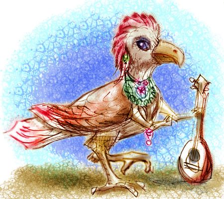
Avian lutist |
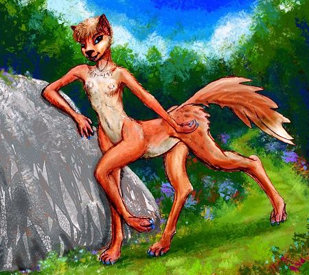
Foxtaur, stray glacial boulder, Arctica |
As I said, part of this is for consistency with Abyssia, but part's laziness. I have a hundred lovely dioramas featuring half a dozen sculptures of three six-limbed species--dogsized foxtaurs, deersize cattaurs, and equi, gracile horse-faced centaurs. I never used them to illustrate Abyssia because the land area was modest; they just weren't needed. Inversia, on the other hand, has nearly EIGHT TIMES as much land--2.2 times Earth's land area. Two or three worlds in one! That's why I've put it off so long; gonna be grueling.
So I'll need a LOT of Inversian illustrations--scenery, people, cultures--over the next few years. Waste not, want not...
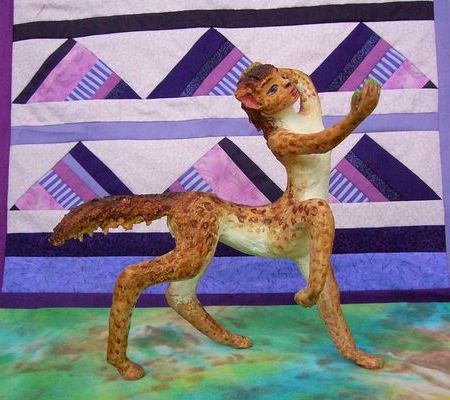
Leptaur; backdrop signifying the Mariana Mts. |
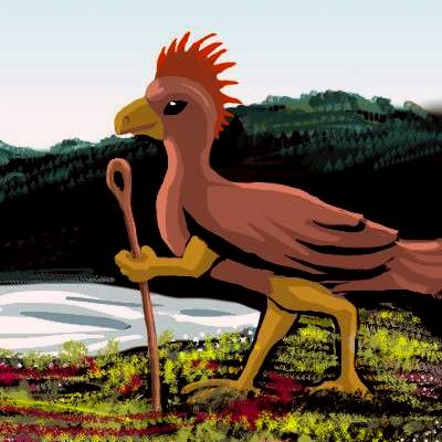
Large avian at sunset |
All this is a side issue, of course. The real one is... a lot of Inversia's harsh. On this tour you just get steamed to death. Elsewhere, things will get difficult.
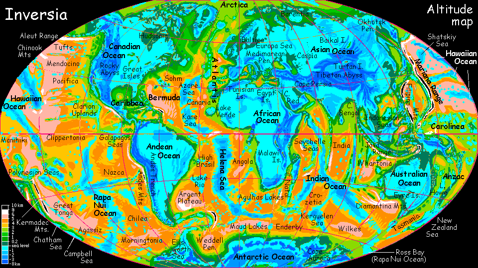
CLICK A REGION for local maps & illustrated tours. Many areas still lack tours, though. These are done:
Arctica -
Canadian Ocean -
Amazon Ocean -
Medimarea -
African Islands -
More worlds: see Planetocopia
World Dream Bank homepage - Art gallery - New stuff - Introductory sampler, best dreams, best art - On dreamwork - Books
Indexes: Subject - Author - Date - Names - Places - Art media/styles
Titles: A - B - C - D - E - F - G - H - IJ - KL - M - NO - PQ - R - Sa-Sk - Sl-Sz - T - UV - WXYZ
Email: wdreamb@yahoo.com - Catalog of art, books, CDs - Behind the Curtain: FAQs, bio, site map - Kindred sites