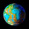
 Medimarea
for those darn Europeans
by Chris Wayan, 2020
more planets: Planetocopia
Inversia homepage - (not done, don't click:) geography & climate - evolution - peoples - map & tours
Medimarea
for those darn Europeans
by Chris Wayan, 2020
more planets: Planetocopia
Inversia homepage - (not done, don't click:) geography & climate - evolution - peoples - map & tours
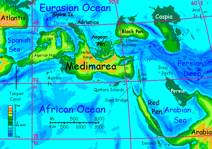
Introduction - West - North - Black Pen. - Caspia - Persia - Red Pen. - East - Central again - West again - Biology
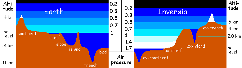
This tour covers the complex of peninsulas and big islands in the Eurasian Ocean corresponding to our Mediterranean region. For Inversia, with 2.3 times Earth's land area (biggest in all of Planetocopia) the Medimarean complex is miniscule, barely 5 million square kilometers (2M sq mi). That's just 1.4% of Inversia's land, compared to Europe's 6-7% of Earth's.
But it's all fertile and densely populated on a world that's mostly not. Indeed, Medimarea's still arguably Inversia's heartland.
Medimarea is sunk deep in the Eurafrasian Basin, where conditions really aren't that Earthlike. Air pressure down at sea level is nearly 1.7 atmospheres. That traps heat! This isn't Europe, or the Mediterranean; our air pressure and temperatures aren't reached until you've climbed nearly 3 km (c.9,000'). Natives are comfortable with the heat and take advantage of the high air pressure: many of them fly.
We'll sail west to east along the more complex northern coast, out to Caspia, the world's largest island, then swing down past Persia, up the Red Peninsula's east coast, then through the islands along Medimarea's south shore back to our starting point.
We'll set sail in early winter, so as to keep the temperatures in a hot but Terran range as long as possible. At least you'll reach the hottest lowlands, Persia and the Red Peninsula coasts, in late winter, when, briefly, they're almost bearable.
Intro - Western Medimarea - Central - Black Pen. - Caspia - Persia - Red Pen. - East - Central again - West again - Biology
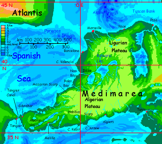
Set out on a sailing vessel from deep cliffwalled Gibraltar Bay, a few miles east of the Canal, on Gibraltar Isthmus, the landbridge between Medimarea and Atlantis to the west.
Northeast along a relatively gentle coast--for a day or less. Then...
The Mazarron Scarp, up to a kilometer high.
The Balearic Lakes--at 1-2 kilometers above sea level, these lakeshores are still considerably warmer than our Balearic Islands. Less muggy than many areas of Medimarea, because the surrounding plateaus snag a lot of the rain off the Eurasian Ocean. The lakes are almost Mediterranean--well, except for the life-forms, adapted to higher air pressure than Earth's. Fliers abound. If a farmer on the banks of the Ibiza River says "When pigs have wings" she may not mean "never" but "when you get down near the rivermouth."
Barcelona. I doubt that surreal cathedral is anything like Christian--such dogmas seem to rise mostly from deserts, where strict codes really can save your life. With Medimarea's generous rains and lush ecology, a polytheistic fertility cult's more likely to build that gigantic temple full of organic shapes--jungles seem to encourage that.
But I'm confident there will be a wildly innovative Temple Of Something. Barcelonans have to build stuff like that. It's something in the water.
Marseille. Nice. I mean, the town of Nice. It's probably nice too. If you like it mild and rainy in winter and hurricany in summer. Very lush.
Inland is the Ligurian Plateau, a lake-dotted highland at 2500 meters--lifting it out of the dense greenhoused air of the Eurafrasian Basin to almost exactly the same air pressure and temperature as Earth at this latitude. Much more like our South of France than muggy Nice down on the coast!
There's a rather Polynesian archipelago to the north--hot, craggy, rainy, green--the Alpine Isles are the inversions of Earth's deep fjord-lakes at the feet of the Alps in northern Italy. Garda, Maggiore, Como and the rest are great serpent-walls of jungle heaving from the sea. Wildly scenic, but baffling. How the Inversians will explain them, I don't know, but "They were gouged by the vanished glaciers of a nonexistent mountain range..." Yeah, right.
A long side trip up the Corsican Valley to Lake Sardinia. Deep, scenic! Little ports, all stone and looking ancient. They are. Our Mediterranean's prone to droughts and flooding (remember, the Mediterranean Sea dried up between five and two million years ago, and the Black Sea basin only filled 7-8000 years ago--probably causing our legends of the Great Flood) but the Inversian version (sorry), while tempestuous every summer, is stabler year-to-year--warm to hot, with generous rains--though not the hurricanes of Nice. High plateaus all around--Liguria, Tyrrhenia, Sardinia to the south--shelter it from the worst of the Eurasian typhoons. More sun; more open woods. This stable, moderate climate has supported a dense population all the way back to prehistory. The basin's rich in ruins--and living towns rising from the forest.
It may not be obvious at first glance, but that forest is highly cultivated--orchards, really. The locals' wings mean the canopy's easy to harvest. Why clear fields for annual crops when huge perennial trees are easier and more productive?
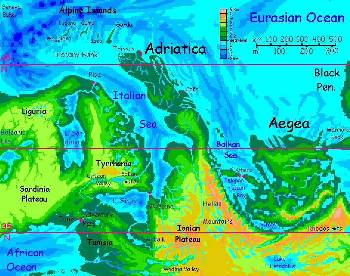
Back down to Lake Corsica and the sea, at Pisa. I forgot to mention--yes, you should see the Tower. It leans the other way, of course, this being Inversia, but I'm not so mean-spirited as to insist the opposite of a Leaning Tower is a Leaning Hole in the Ground. That would be silly. Besides, it's too rainy. Leaning Pool... no. Just not a tourist draw.
That long detour to Corsica and Sardinia was just a rehearsal. All this north coast is convoluted, and now comes the biggest detour of all--down the long Italian Sea. The west coast, Tyrrhenia, rises to a plateau higher than Liguria, but more broken by pools and pits. It's volcanic country--dozens of old calderas overlap, cupping cliffwalled lakes. Not all the vents are dead; in the Eolian Valley in southern Tyrrhenia, Lakes Vulcano and Stromboli are hot, and the spas on the shore have to evacuated now and then when things get too vigorous.
At the southern tip of the Italian Sea we reach the riverport of Messina, and into Lake Sicily. Along these shores, the forest opens up, the sun peeks through. Not fully shielded from the worst storms off the Eurasian Ocean, but a mild rainshadow. Still more Burma or Yucatan than Italy, but wingless tourists like you can occasionally get vistas through the trees. The most scenic side trip is up the Ustican Valley--caldera-lakes, warm springs and cliffs, but sunnier and more open than Eolia to the east. Indeed, Ustica's almost... Mediterranean.
Intro - West - Central Medimarea - East - Black Pen. - Caspia - Persia - Red Pen. - East - Central again - West again - Biology
Back up the Italian Sea--its Adriatic coast is a low rainforested plain. A steambath in summer, it's still quite warm now, in winter. Rain, sun, rain, sun, a dull trip back north to Trieste. But beyond this port, south along the east shore of Adriatica, exposed to the typhoons off the Eurasian Sea, is a scenic (and geologically peculiar) stretch--a maze of long limestone ridges and sounds.
In our Mediterranean, this coast is a patchy landscape of (small) fertile bottomlands and (extensive) barren ridges--the limestone doesn't hold water well. Scenic but not rich. But on Inversia, rains are heavy and year-round--this coast faces the storm-paths directly. So it hardly matters that the porous limestone drains it fast; lush forest all over! More Vietnam or Yunnan, all cloudy crags and gnarled trees clinging to cliffs. And... under their roots, the ridges hide great caverns; Inversia's largest known cave is of course the V-shaped gallery nearly a kilometer long, each arm over a hundred meters wide and high, giving its name to the nearest town, Split.
The Balkan Sea... Down to the charming city of Athens, well west of our equivalent, straddling the Strait of Corinth, opening into Peleponesos Bay.
Be sure to explore the spectacular Ithakan Lakes on the west shore of Peloponesos Bay, with cliffs rising 3600 m (12,000'). A bit farther inland the Hellas Range rises nearly 5 km (16,000'); in the dense warm air, that's only equivalent climatically to a bit over 2 km (7000') on Earth, but at this latitude that's enough for heavy winter snows.
Just wanted to emphasize that while much of Medimarea is steamy by human standards, details matter. Details like mountains three miles high.
The Ithakan Lakes are wildly popular with Medimareans--warm swimming at the feet of gigantic snowy peaks. If you were sad about the loss of those famous resort lakes of Northern Italy, these are better, and a lot more extensive--the whole Cretan Valley has snowy peaks above nearly hot-tub lakes. This batch, unlike those above Lake Sicily, aren't volcanic; just warm because they're so deep in the Eurafrasian greenhouse.
What's over those jagged mountains? Lake Herodotus and the central highlands, the right altitude to be roughly like our own Mediterranean in temperature, though still a bit rainier--no real dry period in summer. Yes, the Hellas Range is a formidable storm-wall, but the Eurasian Ocean is a wee bit bigger than the Mediterranean, and warmer too; it generates a hundred times the rain. So it looks Mediterranean, the Herodotus Valley, but it's not quite. Fewer grapevines, they'd get moldy I think. The ancient Medimareans may not have even had a god (or goddess) of wine, but they've always grown coffee on these mild uplands.
Really, it makes more sense than wine did. Greeks, logic, caffeine, staying up all night arguing...
Athena, the Goddess of Coffee.
The east shore of Peloponesos Bay has little ports on valleys leading up into the Aegean Peninsula and its myriad lakes--the inverted equivalents of our myriad islands. These have a lot of what seem to be fortified hill-towns. Does the region have a history of war, as our Aegean did?
Yes... but the enemy's invisible. This region is as volcanic as around Vulcano, so many of the lakes are a bit, um, fizzy. Not too safe to build next to! They only belch fatal clouds of carbon dioxide every generation or ten, but when they do, whole harbor towns can die. CO2's heavier than air, so the locals build on hilltops above the invisible floodline. It's a bit inconvenient--they have to fly down to their fishing boats and orchards, yes, and fly home to sleep--but much better than getting strangled in your sleep. Great views, too.
The frequent quakes make fairytale castles like Neuschwanstein impractical, but clifftop villages quite like Italian and Spanish hill towns are common.
Thus Vulcan begat Quaintness. And Quaintness begat Tourists. A lot of the locals--whether birds with hands or winged mammals--aren't really local at all. Sightseers like you.
We sail north out of Peleponesos Bay, north toward the long fjords of northwest Aegea. Now on Earth, these are peninsulas famous for monasteries that hate and exclude women. So I suppose on Inversia we ought to have nunneries excluding men. But really, that's a small-hearted inversion; surely we can do better. Ah. The Temples of Sexual Healing! A multi-species staff dedicated to helping raped, abused, bullied, shamed and just plain inhibited creatures lose pain and fear and get their mojo back. No species turned away! Surely there is no holier mission.
Asklepios, the God of Healing, might just approve after all.
In the heat, no need for either monk's robes or long white lab coats. Though I suspect most of the Inversians are furred or feathered anyway, so the fact that over at the School for Sexual Healing all the doctors (and patients) are naked won't stand out from other Medimarean towns. Unless they want to, and cults often do. The wise pilgrim's garb will be, I think, to wear goofy Carmen Miranda hats. Color is sexy, and so is wide-brim shade, in the Medimarean heat.
Intro - West - Central - Black Peninsula - Caspia - Persia - Red Pen. - East - Central again - West again - Biology
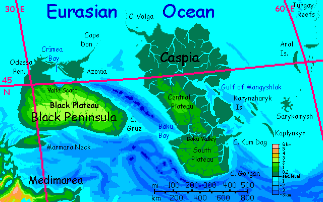
We sail east along the north shore of the rolling, hilly Isthmus of Marmara, and, at the narrows of Stamboul, pass Constantina's Canal, dug some 1700 years ago. Let's not cut through it to the south; still things to show you up north.
Up the west coast of the huge Black Peninsula, big as Borneo. Steep coastal hills, with cascades and waterfalls--the rim of the of the Black Plateau, about 2100 meters up (7000'), covering half the Peninsula. It's called that less for its dark dense woods (though they are: the Black Forest, in fact) but the soil.
After a couple of days, the hills drop away; the northern half of the Black Peninsula is as flat (and hot) as much of Adriatica was. A day or two of monotonous rainforested plains as we round Cape Odessa and sail down Crimea Bay to its dramatic head...
Yalta Scarp! Here the central plateau rises abruptly, two vertical km in less than one horizontal. Unlike our world's Crimean cliffs, these, getting triple the rain, are laced and streaked with waterfalls. At the east end, the scarp extends undersea too; hanging coral gardens as deep as you can go... which isn't very far, since the high air pressure brings on nitrogen narcosis sooner here than on Earth; hits some at just 15 meters down, and everyone by 25. Do NOT scuba. Stick to free diving and don't push it.
The swampy coast of Azovia. Might as well be the Sepik or the Fly River of New Guinea--muggy weather, dense forest, muddy winding rivers.
Next we sail east-northeast, following the Don Reefs (with their palm trees and coral banks) to...
Intro - West - Central - Black Pen. - Caspia - Persia - Red Pen. - East - Central again - West again - Biology
We make landfall at the tip of Cape Volga.
Caspia is the biggest island in the world--some 750,000 square km (c.300,000 sq mi). It's nearly twice as big as our Caspian Sea--that only fills the bottom of the Caspian Depression. Inversia's inversion turns all of that basin into a rise above sea level. Most of the extra, unexpected land's in the north--a wide rainforested flatland like a triple-sized Yucatan.
Triple the rain, too. Caspia is much wetter than our Caspian. The island's in a blood-warm sea, warmer than any on Earth, and in a typhoon corridor, getting the brunt of every storm. All the rest of Medimarea's downwind, getting Caspia's leftovers--still a lot of rain. But northern and western Caspia are drenched--winters aren't dry, but summers are typhoons back to back.
Two highlands, the higher Central Plateau (still just 1500 m / 5000') and the Southern (just 1200m / 4000'), split by the Baku Valley. Being somewhat rainsheltered, the Valley has the openest woods on Caspia--which isn't very. You're lucky to get any clear views. Even now in winter warm rains fall every two days. Feels equatorial--at 45° north. That's what 1.6 atmospheres will do.
The Aral Islands--scattered over hundreds of kilometers, not just the bed of the Aral Sea itself. Quite a few dips below sea level in these steppes on Earth, becoming low, rainforested islands on Inversia. Notable:
Sarykamysh, big and octopoid.
Kaplynkyr, a splendidly named curving scarp rising from the sea. A lot of similar cliffs, 50-100 meters tall, wind across the shallow sea floor but don't rise above water level, creating gorgeous, bizarre vertical coral gardens--but must I repeat my warning? I fear so. Beware the Rapture of the Shallows!
The Turgay Reefs, a chain so long it leads right off this map and out of this tour, all the way to the Ob Peninsula of Arctica.
There may be reefs on the Kara Bank south of the islands, too, off Cape Kum Dag (which sounds like the stage name of a really bad rapper, but is Turkic for Sand Hill or Desert Peak. Naturally, the cape is rainforest. Not even much beach sand--mangroves wade into the sea. Oh well, it's Inversia.)
This region's barely above our sea level, so the Inversian sea is shallow; coral will easily build up to low-tide level in many places. It'll be as much of a maze as our Great Barrier Reef. Get a local guide.
I should note that these waters are far too hot for Earth's coral species. But Inversia's basins are millions of years old. It's temperature change that stresses life, not the absolute level. These reefs are as rich as any on Earth; the only notable difference is that the warm water won't hold as much calcium in solution, so corals are more chitionous and flexible--though still quite tough, like kelp holdfasts.
Oh. One other difference. Flying fish aren't a species but a way of life. Hundreds fly. In air this dense, it's much easier than on Earth.
Sail south, to...
Intro - West - Central - Black Pen. - Caspia - Persia - Red Pen. - East - Central again - West again - Biology
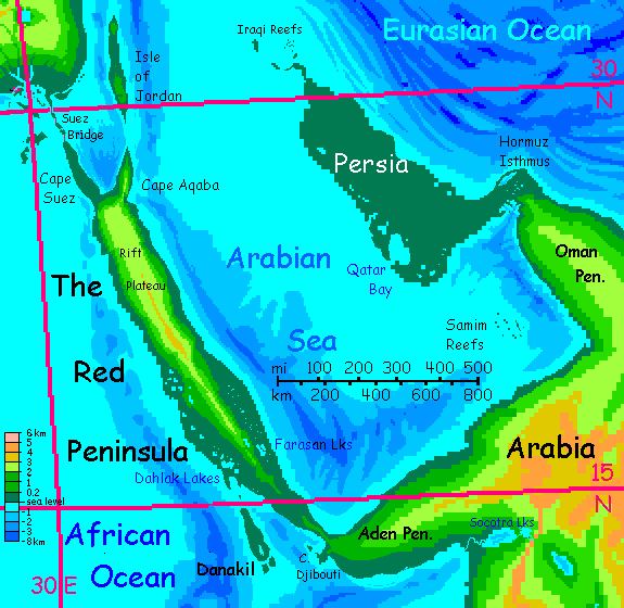
This low, verdant peninsula is Inversia's equivalent of our Persian Gulf. Still hot--maybe hotter--but drenched year-round. Typhoons weekly for months. Some years there is no dry season to speak of. We make landfall in late January, coldest time of year... and you're wilting from the muggy heat.
Humans simply can't live here--in summer the heat and humidity are fatal, and unlike all other lobes of Medimarea, you can't flee to the hills for relief. No hills.
But the locals, who evolved in this deep greenhoused basin, do just fine. Rainforest, giant tropical birds and flying mammals (again, the high air pressure makes flight easy). I'm making it sound like our Amazonia--a biologically rich wilderness, sparsely populated. Not so! There are farms, villages, universities, whole cities up in those trees!
True, they're all woven out of basketry. So what? Less flimsy than our Web.
Off the west coast, the Arabian Sea is shallow for hundreds of kilometers out. Coral reefs everywere. I haven't even tried to map them--they're too dependent on currents and nutrient flows that are hard to predict. Be sure you've got a local pilot.
To the west and south, it's a little deeper, except for the one patch of reefs I have marked, Samim. Beyond it, a bit too deep for coral to build to the surface. More than a bit, along the west shore of Oman Peninsula--a trench up to 3 km deep (10,000'). Makes for safe sailing, though. Trouble is, the shore's desert. Seems an abrupt and unlikely change from Persia's rainforest just a few hundred km north, but it's so. Most of the year, the typhoons lashing Persia mostly roll in from the east. Oman's spine is quite high and rugged, blocking those storms. In summer, winds shift for a few months; this monsoon drenches Persia from the southeast and south. But along Oman's coast, those summer winds come off the highlands of Arabia--and this corner of the Arabian Sea is just too narrow to rehumidify that air.
Latitude and geography thus combine to make this coast nearly as dry as it is on Earth. Not quite--very hot, but not true desert. Dry savanna with scattered thorn trees. Another world, and not one you expect to find on the shore of the world's biggest ocean. But then, Baja California and the Atacama desert front the Pacific. An ocean's no use if the winds always come off land!
Intro - West - Central - Black Pen. - Caspia - Persia - Red Peninsula - East - Central again - West again - Biology
The Red Peninsula is called that because much of its soil is red-stained with iron (and a lot of other metals), being new land thrust up by an active, spreading rift. It's not called Red because it corresponds to our Red Sea--of course not!
Like Persia, most of The Red (as locals call it) gets plenty of rain--unlike the Oman coast, it's got wide seas on all sides. The rain's more seasonal--mostly in summer--but fairly regular. The Red's a steambath fatal for humans--at least at sea level. But the Peninsula has a mountainous spine up to 3 km high, and up there on the Rift Plateau, the heat's merely uncomfortable. Still muggy as Karachi on a bad day, but survivable. Even (in late winter, which it is now) nice.
Some fascinating volcanic vents up there, too. If you like mud.
From the northern tip of the Red Peninsula, at Suez Bridge, we could veer south along the Red Peninsula's west shore. Let's not. It's not just the heat; turning south would start us on a tour of the African Ocean, and I haven't written that yet.
Well, except for the Malawi Islands...
The mountains of The Red cast a rainshadow. If we did sail south along the Red Peninsula's west coast, temperatures would be searingly high, but the humidity? Not bad. Sheltered by the mountain-spine, this coast gets less rain. It looks truly Mediterranean, with open forest, meadows, rocky heads worthy of Greece. Just hot as Egypt. Hotter. The Caspian lowlands, already hot as Earth's equator, were 45-50° north; but the Red Peninsula's south end is just 12° north.
Off the southwest shore is Danakil Island, one of few places on Inversia even faintly like its Earth counterpart. Our only lands that are also land on Inversia are desert patches sunk below sea level--places so dry they can't form lakes. Our Horn of Africa's Danakil Depression is not unique in this--Death Valley and the Dead Sea shore (spot a trend here?) stay land on Inversia.
But usually, such twins--hmm, not antipodes, what are they?--invertwins! Such invertwins normally have opposite climates. Most deserts are dry because they're cut off from the sea and its rains, but that means they get inverted to islets in broad seas with plenty of rain.
Danakil Island is a rare exception. Downwind of the highlands of Aden and the Red Peninsula, it gets sparse rain and relentless sun--plus, the high air pressure traps all that heat. Danakil Depression is one of the hottest, driest, nastiest spots on Earth; Inversia's Danakil Island is nearly as bad. Hotter. Not as dry--scattered trees attest to a monsoon season, and give enough shade year-round for it to be inhabitable by locals. Stoic locals. Even for them, it's hardly prime territory. Flat, hot, and most of the year, fly heaven.
Don't go.
Instead we'll sail straight up the Red Peninsula's east coast, and from Capa Aqaba, not turn west toward the long, many-spanned Suez Bridge, not yet. We go straight north from Aqaba's tip, Cape Petra, to Jordan.
Intro - West - Central - Black Pen. - Caspia - Persia - Red Pen. - Eastern Medimarea - Central again - West again - Biology
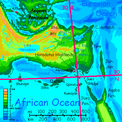
This region is locally called the Levant. The east coast is nearly as hot and rainy as Caspia, and so is the long narrow Isle of Jordan (but why is its high point, that long swell of dripping cloud forest, called the Dead Plateau? Life all around you. Well, yes, the mold will kill you. Eventually.)
The lower Cyprus Valley's hot and rainy too, around the great lake. But the northern highlands, above Lake Cyprus, are cooler; and upriver, the Rhodos Mountains around two-lobed Lake Anaximander cast a rainshadow; opener woods, cool enough now in winter so you might actually need a sweater after sundown. These mountains--the east end of the Hellas Range--are even more Earthlike, for near Lake Rhodos they rise nearly 5 km (c.16,000'). Pleasant in summer, and cold enough now in winter to amass serious snowpacks.
In the southeast is the Nile Fan, a broad conical slope--are just half as high as the Rhodos Range; mild now in winter. And fertile. Heavy rains but good drainage.
At the top of the slope is Lake Eratosthenes, a roughly round cliffwalled mountain lake nearly 100 km across. A caldera? I'm baffled what its inverted self is on Earth--a big guyot, far too deep to have ever been coral, but flat-topped, round, cliffwalled, scalloped, like a fat coin tossed on the sea floor, or one section of lost Greek column fifty miles across.
We sail under the long century-old Suez Bridge--really three causeways between capes and islands (the oddly named Bitter Islands) linking Red Peninsula and Medimarea. We sail west another hundred-plus kilometers along Medimarea's south coast to Alexandria, its harbor sheltered by Maryut Island. Despite the bridge to the east it still dominates trade in the area; thousands of years of infrastructure don't move overnight.
Be sure to visit the lighthouse. I can't invert that. Shining a light from a hole in the ground doesn't help shipping at all. It's still a tower. The only inversion I can offer is that it didn't fall a thousand years ago in that mega-quake.
The Alexandrian library is a must-see; this is Inversia, so it didn't burn (but the tsunami from the quake did flooded the ground floor, so the older scrolls had to be hastily copied and are full of misspellings.) But if you don't mind typos, you can always buy a fresh-printed edition of Sappho's complete erotic poems or all forty comedies of Aristophanes. Sigh! Though you'll have to adjust to Sappho having been a gliding lemur and Aristophanes a cattaur. Details, details! Really, the emotions--love and humor--are panspecific; any creature smart enough and sociable enough to build a civilization will share them. Ravens, humans, elephants, parrots, dolphins and wolves understand each other surprisingly well given their diverse lineages and forms. Inversians aren't that alien--even if they look that way.
And sound that way. You can scold them a hundred times--parrots in the library just won't shush.
We are far too highbrow to insert Terry Pratchett jokes about those long-armed, shaggy, reddish librarians who retrieve those hard-to-reach books for you by climbing the walls. Ook!
Up to 200 miles offshore, the low, broad, hot, forested Qattara Islands. They're the equivalent of a long line of sinks below sea level stretching across our Egypt into Libya; some are quite visible since they're oases; others are dry basins easily overlooked (all five of my main reference atlases show them differently--or not at all). But on Inversia, they're all fertile and densely inhabited. A hotter Polynesia.
Inland to the north, the Herodotus Plateau rises to 3 km (10,000'). At that height, air pressure and thus temperatures are much what they are in our world at thirty north--Los Angeles or Cairo. Mild now, even cool--but hot most of the year. And that's the highlands! Where Alexandrians go to escape the REAL summer heat back home, ten thousand feet deeper in the greenhouse... quite fatal for humans.
Intro - West - Central - Black Pen. - Caspia - Persia - Red Pen. - East - South-Central - West again - Biology
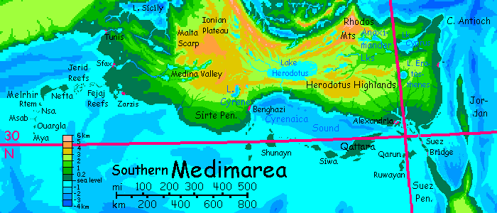
We sail west through the Gulf of Cyrenaica. The Herodotus highland narrows; a narrow mountain wall now. A great canyon cuts through, draining Lake Herodotus, on the far side, big as Lake Cyprus. The valley's warm even now in winter--it's barely a kilometer up.
The port of Benghazi on the Cyrene River. Far inland, a mile up, L-shaped Lake Cyrene with its cliff walls up to 2 km high at the north end where peaks reach 4 km (over 13,000'). That's high enough to be snow-dusted right now in late winter. Like the Grand Canyon snow-frosted.
Past Benghazi, the coast turns south. The broad bulge of Libya, called the Sirte Rise. A long slope rising steadily for hundreds of km to the Ionian Plateau, also 4 km high (13,000'). This triangular region is the largest highland in Medimarea--high enough to be mild in summer and actually cool in winter--like the Cyrene Highlands, Ionia gets snow most years. The biggest temperate sky-island in Medimarea, though small by world standards.
If you detour inland, be sure to see Medina Valley, carved into Ionia's west side. Lake-dotted, cliffwalled, laced with waterfalls, Medina's like Yosemite ten times longer.
The west rim of the Ionian Plateau drops suddenly to Malta Plain and Lake Sicily: the Malta Scarp.
Back on the coast... Past Tripoli, the Sirte Rise fades into low hills. Lower. The Tunisian Plain. Lakes, islands...
As the coast turns north, your ship must thread through reefs extending west hundreds of km: narrow Fejaj, wider Jerid, then two true islands, Nefta, a good 40 km across (25 mi), then (nearly linked to Nefta) Melrhir, at least 160 km long and half as wide (100 by 50 mi). Past Melrhir, the chain turns sharply south, straight into the African Ocean: the Mya Reefs stretch nearly 400 km (250 mi) south--not only lovely coral heads and psychedelic fish but splendid names like Rtem Reef, Nsa Atoll, Msab Bank, Ouargla Atoll, and Mya Reef itself. You just can't make up names like that. Well, someone did; but someone Saharan, not Inversian.
We'll avoid all those pronunciation challenges (which do seem evidence the Inversians, or at least the Medimareans, are some sort of flying Siamese cat, all wargle and myaaaa) and stick to the Tunisian coast, heading north into Tunis Bay. Here and here alone, locals can cross Medimarea without climbing into highlands--lake-valleys barely half a kilometer high reach all the way to Lake Sicily (just a couple hundred km, at this narrows).
This low-altitude pass matters not just for land-traffic, but for some of the larger flying species, who find the Earth-normal air pressure of the highlands along Medimarea's backbone quite hard to fly in. Ditto for any flier carrying a heavy load! For them, Adventure Pass is just as real and useful a strait as Suez or the Tangier Canal.
Intro - West - Central - Black Pen. - Caspia - Persia - Red Pen. - East - Central again - Southwest - Biology
The southwest coast is quite different--reminiscent of California's Big Sur or Kauai's Na Pali, but stretching 1250 km (750 mi)--a great wooded scarp rising swiftly to the Algerian Plateau, 2500 meters up (8000'). Cool winters, but snowfree most years. Short streams leap down the scarp, full of cascades and falls.
Only in the last 400 km, approaching the Gibraltar Isthmus, does this great highland slump away. Inland hills still, but the much lower Alborán Range.
Now for the first time the south coast has some echo of the irregularity of the north--the low peninsulas of Arzew and Kebir, then sheltered Melilla Bay with its charming port at the head, then the long lakes of the Alborán Valley, that great diagonal slash. The weather, while consistently hotter than our Mediterranean, is less muggy at this west end of the subcontinent; the high plateaus to the east ward off some of the rain. Both climatically and topographically mild! A rarity on Inversia.
Full circle: at Tangier, we turn north into the Canal, marveling at the sheer heroism of its excavation--the isthmus is narrower than that facing the diggers of the Panama Canal, but higher, over 200 meters (nearly 700') in two spots that had to be cut through; these canal-stretches have brooding stone cliffwalls like something out of Tolkien--the Gates of the Argonath, I suppose. The canal's central lake is 100 meters up, and the locks lifting your boat that high take time to fill. Thus the canal, just 32 km long (20 mi) takes just as much time as Panama's much longer canal. This ridge fights back.
That's Medimarea all over. This stubborn little vertical lump (can't even call it a continent, can we?) is a mere remnant of ancient Tethys, that vast and true continent; but the plates can squeeze for a hundred million years, and the relentless rains off the Great Sea can gnaw away all they like. Medimarea's not Atlantis or Numenor, to drown in a day, or an eon. Not giving up without a fight.
Intro - West - Central - Black Pen. - Caspia - Persia - Red Pen. - East - Central again - West again - Biology -
This little stub will eventually expand a lot as I work out what the natives of the sea-basins are like. The most important thing is: they'll almost certainly fly. The dense air makes it easier for climbers to glide and gliders to evolve to true flight. Way less wing surface is needed to lift you. On Earth, our thin air makes it difficult for large, big-brained creatures to get off the ground, though pterodactyls did manage; but my guess is that in the Inversian lowlands a dozen or more broad lineages will find ways to fly.
Will I duplicate Abyssia exactly? No, for two reasons. Abyssia's air is Earthlike, so big-brained creatures are mostly too heavy to fly. And since it's a sea-world full of islands not continents, there are few large land-predators; many birds became flightless. In contrast, Inversia's dense air in the basins help big fliers fly, and its continuous land (allowing large land-predators to spread) gives them a need to fly.
So my best guess is that in Inversia's deep, dense-aired basins, the dominant life form will be winged, not pterodactyl-huge but considerably heavier than our condors; some mammalian, most avian; in either case, with small but cunning hands.
Outside the basins, in the thin-aired uplands, we may encounter nonflying centauroids running on four feet just as most Terran mammals do, but with small forelimbs sporting dedicated hands. No knuckle-walking in their past! The ubiquity of functional hands means I anticipate multiple lineages developing sophisticated tools, and possibly civilizations; not one as on Earth.

Avian lutist |
Foxtaur, stray glacial boulder, Arctica |
As I said, part of this is for consistency with Abyssia, but part's laziness. I have a hundred lovely dioramas featuring half a dozen sculptures of three six-limbed species--dogsized foxtaurs, deersize cattaurs, and equi, gracile horse-faced centaurs. I never used them to illustrate Abyssia because the land area was modest; they just weren't needed. Inversia, on the other hand, has nearly EIGHT TIMES as much land--2.2 times Earth's land area. Two or three worlds in one! That's why I've put it off so long; gonna be grueling.
So I'll need a LOT of Inversian illustrations--scenery, people, cultures--over the next few years. Waste not, want not...
Leptaur; backdrop signifying the Mariana Mts. |
Large avian at sunset |
All this is a side issue, of course. The real one is... a lot of Inversia's harsh. On this tour you just get steamed to death. Elsewhere, things will get difficult.
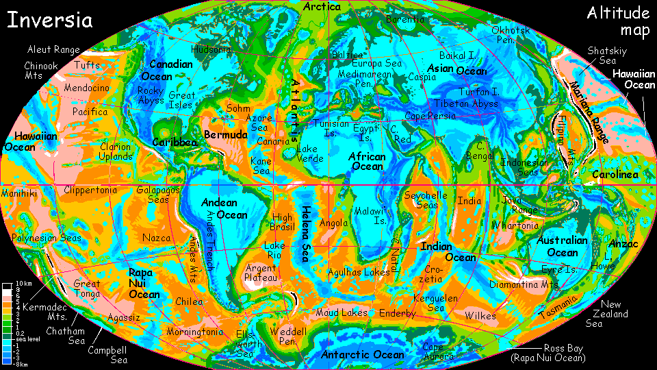
CLICK A REGION for local maps & illustrated tours. Many areas still lack tours, though. These are done:
Arctica -
Canadian Ocean -
Amazon Ocean -
Medimarea -
African Islands -
More worlds: see Planetocopia
World Dream Bank homepage - Art gallery - New stuff - Introductory sampler, best dreams, best art - On dreamwork - Books
Indexes: Subject - Author - Date - Names - Places - Art media/styles
Titles: A - B - C - D - E - F - G - H - IJ - KL - M - NO - PQ - R - Sa-Sk - Sl-Sz - T - UV - WXYZ
Email: wdreamb@yahoo.com - Catalog of art, books, CDs - Behind the Curtain: FAQs, bio, site map - Kindred sites