KAKALEA'S GEOLOGY AND GEOGRAPHY
by Chris Wayan, 2012-2015
for all who've gambled and lost
Kakalea basics--map--geology--
creatures--
Building Kakalea
More worlds? Planetocopia!
KAKALEA'S GEOLOGY AND GEOGRAPHY
by Chris Wayan, 2012-2015
for all who've gambled and lost
Kakalea basics--map--geology--
creatures--
Building Kakalea
More worlds? Planetocopia!
Kakalea was created to make a point: worlds with plenty of air, water and land, with Earthlike temperature and chemistry, can still be largely barren due to geography alone.
There's an easy example of my point in Earth's past: Pangea. It's still true, in fact: the Old World is really a supercontinent, with a huge, harsh interior, mostly desert, steppe and thin boreal forest.
But I wanted to show a different ecopoverty, due only to continental locations, orientations and shapes, not bunching. Hence Kakalea has deliberately un-grouped continents with plenty of sea around them; it's an anti-Pangea.
That means what dominated Kakalea's development wasn't tectonic plausibility. I roughed in the continents first, then worked backward, defining plates, rifts and trenches. The result looks plausible on a continental scale, even a hemispheric one, but looks too even, too neatly spaced, when seen as a whole by a geologically literate Terran. Kakalea's creator isn't an Intelligent Designer, but a Pedestrian sort: call him Plod.
What Kakalea's evenly spaced lands look like, really, is a child's fantasy--an ecotopia where it's all fertile, happy, neat... a veritable suburbia of laid-out continents. Or a well-ordered farm district: the Shire, not the wilds of Middle Earth.
And it should work. Ocean all around! This is known as Geographic Irony. Though I suppose for most readers the irony will be, um, dry.
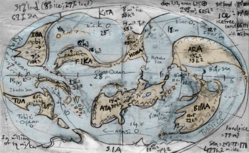
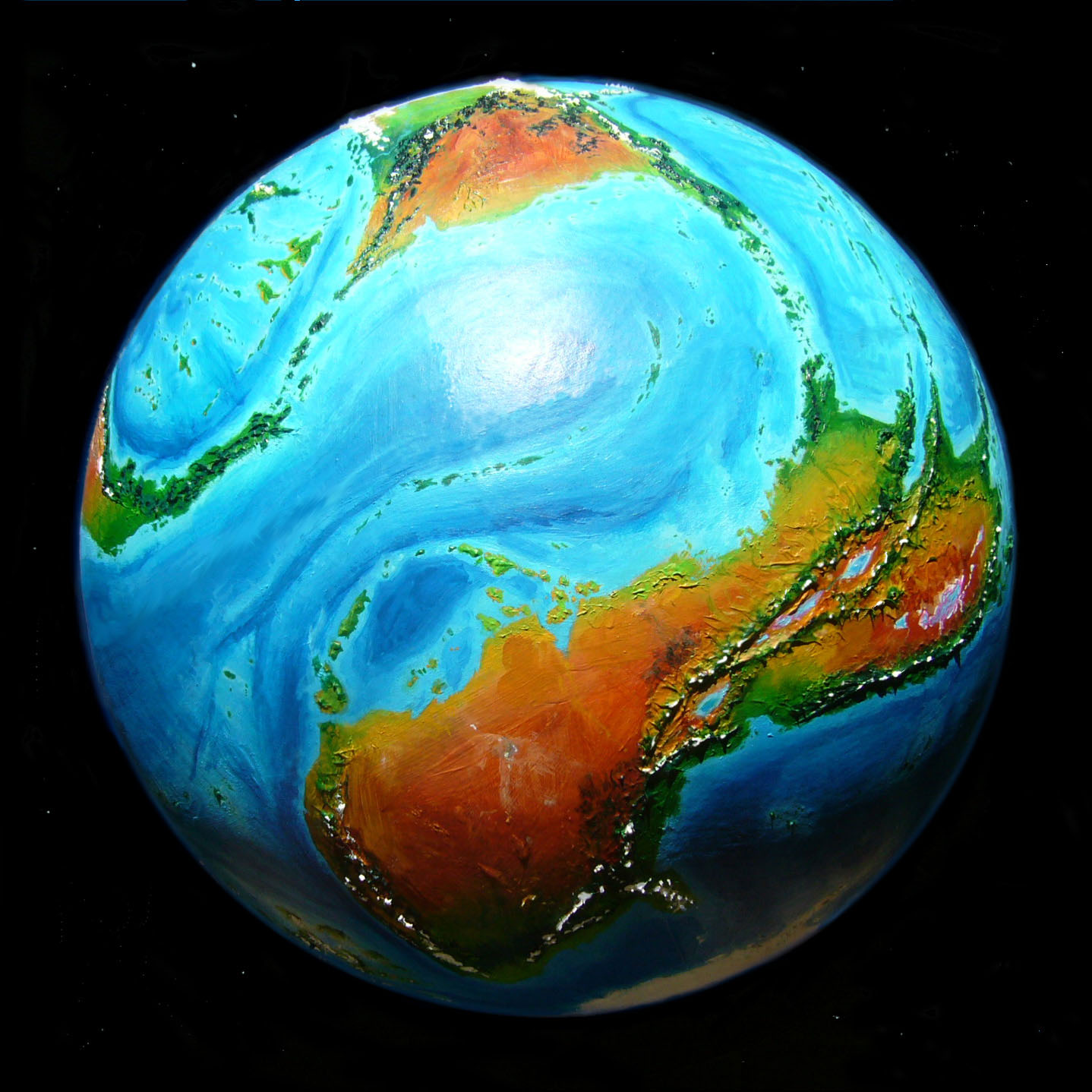
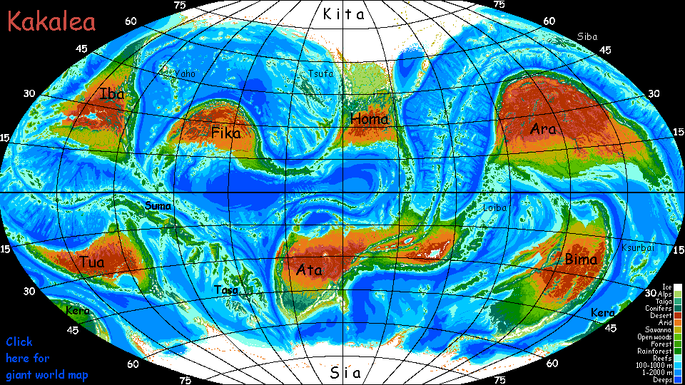
Despite first appearances, these continents do cluster: the three largest, Ara, Ata, and Kita/Homa are all neighbors; and all five smaller continents share the other hemisphere. Earth is just more blatant about it. That's largely due to the Pacific, a huge deep basin that means nearly all our land is crowded into one hemisphere (centered near Vienna, by the way; did Europe's centrality facilitate its centuries of dominance?) If you foreground Kakalea's oceans, for a moment, you'll see it isn't just landmasses that are more scattered and numerous; I count four to six major ocean basins, too, not three as on Earth. So wet or dry, high or low, all Kakalea's plates tend to be (modestly) smaller. It's not as big a difference as it first seems; break up the Pacific (say, scoop out north and central Asia and drop it in the South Pacific. Believe me, the Mongols & Siberians won't mind) and Earth would suddenly look like Kakalea. But greener; and that's the point.
Kakalea and Earth have similar percentages of land and sea, but geologically, Kakalea's a bit of a wimp. Its shallow seas disguise how small its continental platforms are in volume. Erosion wears high ranges down into floodplains at or near sea level; if Kakalea had deep Terran seas, continental platforms would be much narrower: lots of Patagonias and Central Americas, with a total land area only half Earth's. Kakalea's extensive continents are a blessing bestowed by relative aridity. In this sense, and this sense only, Kakalea's deserts are due to a global water shortage. A drowned Kakalea wouldn't have big red patches. But still no big green ones. Not with the continents in their present positions.
So remember, as you contemplate my rigged geological dice, that the Great And Merciful Plod could easily have made it worse. Terran sea levels would likely reduce the area of fertile land, not just land in general.
Kakalea necessarily lacks a few other Terran features. Since Plod's an Unintelligent Designer, neatly scattering the continents to make a heavy-handed point, none are currently colliding head-on: so we see no great plateaus like Tibet. None of the subducting plates are moving so violently as to create an Altiplano, though some of the (single, narrower) Kakalean coast ranges do reach Andean heights.
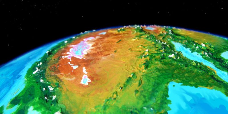
Not collision but spreading gives Kakalea its most extensive highland: in eastern Ata the worldwide rift system climbs onto land, forming a split highland much like Ethiopia's. This low orbital shot looking west shows this sky-high oasis winding through deserts full of salt lakes and flats. Note how the central rift (upper right) forms first a sound, then a long desert valley, then cups salt lakes (horizon)--they're unable to drain to the sea. It's quite like Aden, Ethiopia and northern Kenya around Lake Turkana.
As you look at this desert and the salt pans, consider: this is about as green as Kakalea gets.
In deep time, of course, rainforests will reappear; some continent will drift into the equatorial belt. It's a huge zone--our brains, used to judging area on flat surfaces (and to seeing Mercator maps) may think it's perhaps a sixth of the planetary surface, since it extends from the equator one-sixth of the way to each pole (about 15°), much as on Earth. But the equator is a line; the poles, mere dots. In fact the equatorial belt is fully 1/4 of the planet! Yet it lacks much land, and that absence is the most statistically unlikely thing about Kakalea's rigged arrangement, more so than the odds against two polar continents or the land shortage in the temperate zones.
Kakalea does have one ecology Earth currently lacks: a mid-latitude icecap such as we had twenty thousand years ago. The half-iced-over continent of Kita-Homa resembles ancient North America, with tundra and taiga (thin Siberian forest) halfway to the equator. So Kakalea is in an Ice Age of sorts, just not a showy one; it's just chance that only one continent was placed so it could grow a temperate icecap. If Sia and Bima were linked by a landbridge, Bima's southern half might well have iced over too. Or Kera. Ice breeds ice.
Plod Almighty could just as well have built endless Siberias or Ice Age Americas as Australias, I guess, but it's hardly an original way for a world to go wrong--a Terran reader would come away thinking "An ice age, so what else is new? This planet's too cold, that's all." I tried to design Kakalea so it's clear that cold is not Kakalea's problem.
So what is Kakalea's problem?
Answer: nothing! On a global scale, Kakalea's fine. Not too hot, too cold, too wet, too dry. Instead, each continent is just passing through a bad patch in its slow journey round the world--a dry latitude, a twist of the rift, a mountain range in the wrong spot--that's all.
Plod is not cruel as deities go--not even inept, really. Kakalea has solid bones. In eighty million years--hell, in forty--the long drought will pass.
LISTS AND LINKS: More worlds? Planetocopia! - dreams of other worlds - ecology - climate change - evolution - natural disasters - terraforming - sculptures and 3D art -
World Dream Bank homepage - Art gallery - New stuff - Introductory sampler, best dreams, best art - On dreamwork - Books
Indexes: Subject - Author - Date - Names - Places - Art media/styles
Titles: A - B - C - D - E - F - G - H - IJ - KL - M - NO - PQ - R - Sa-Sk - Sl-Sz - T - UV - WXYZ
Email: wdreamb@yahoo.com - Catalog of art, books, CDs - Behind the Curtain: FAQs, bio, site map - Kindred sites