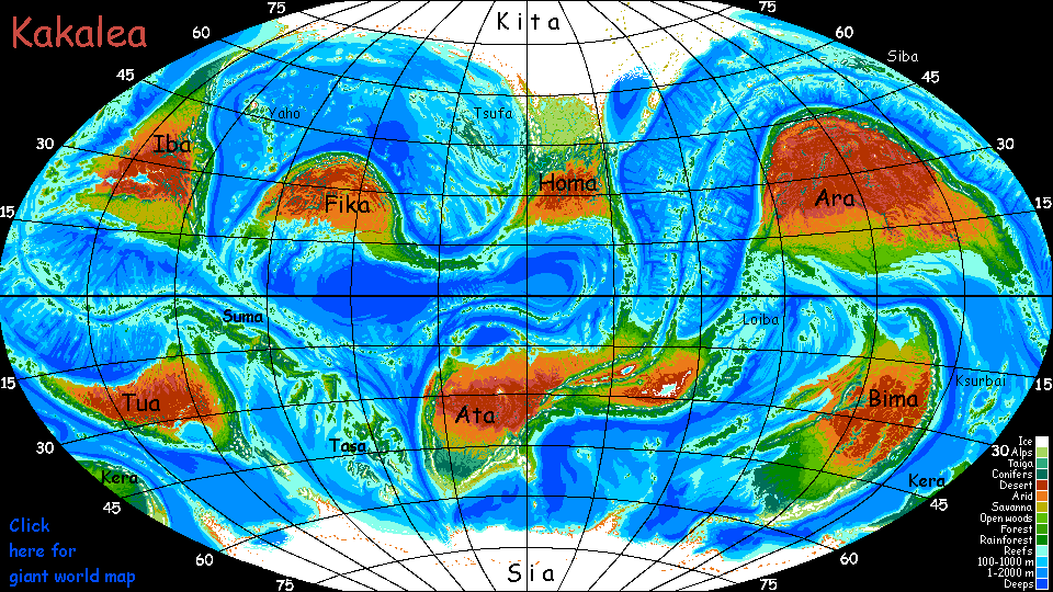
Kakalea:
BIMA
under construction--north still just outlined
by Chris Wayan, 2012-2015
for the Patagonians
Kakalea basics--map--geology--
creatures--
Building Kakalea
More worlds? Planetocopia!
Kakalea:
BIMA
under construction--north still just outlined
by Chris Wayan, 2012-2015
for the Patagonians
Kakalea basics--map--geology--
creatures--
Building Kakalea
More worlds? Planetocopia!
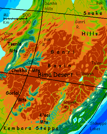
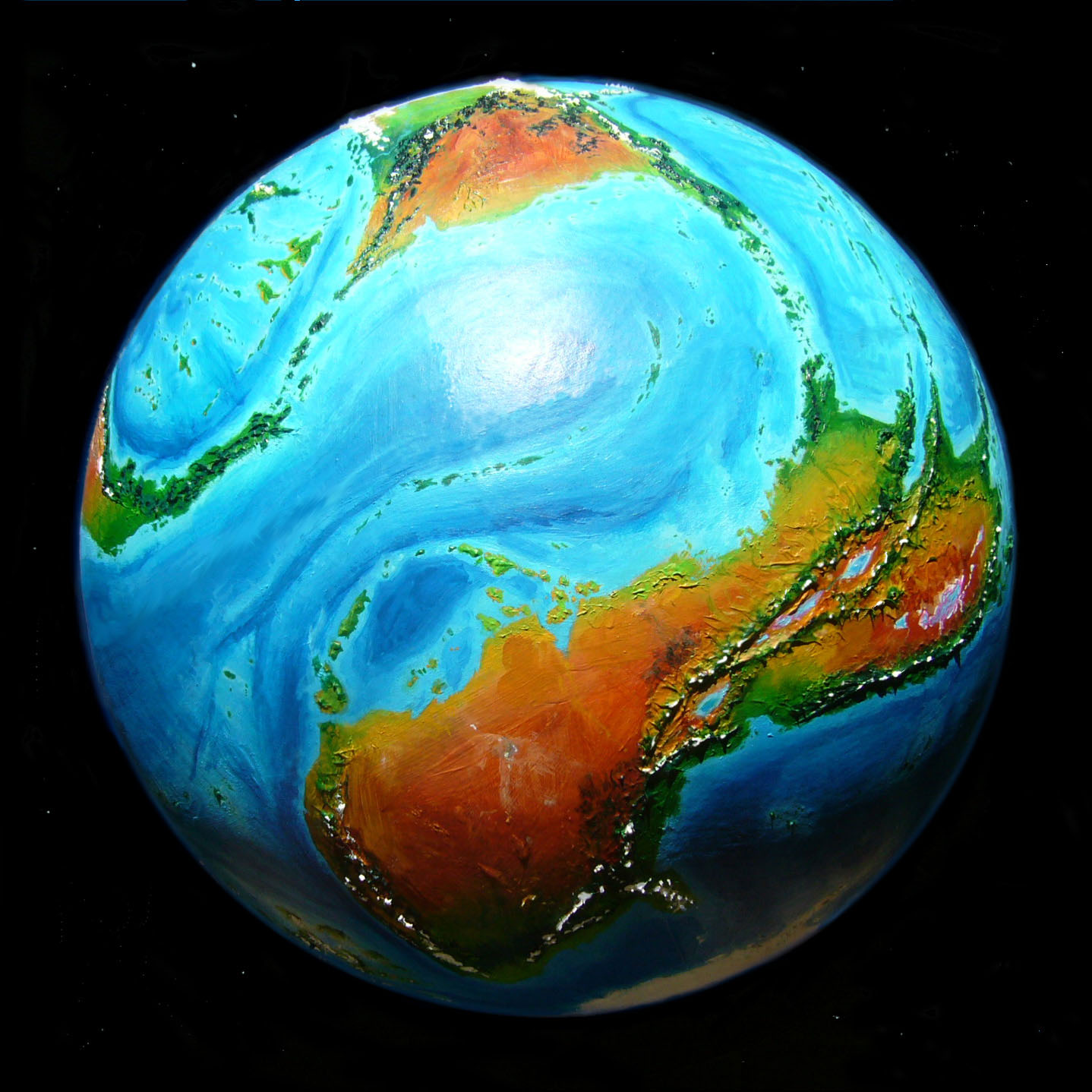
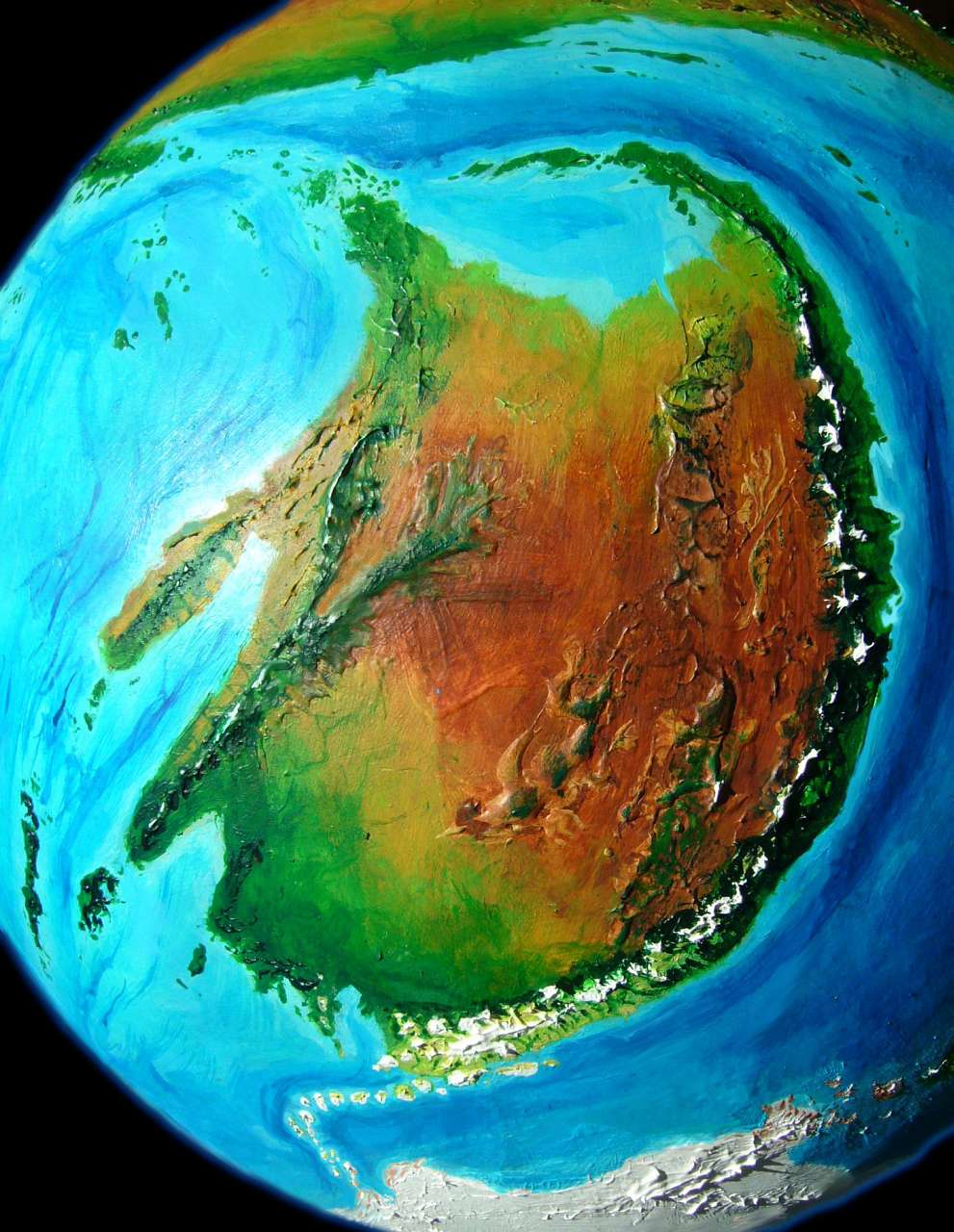
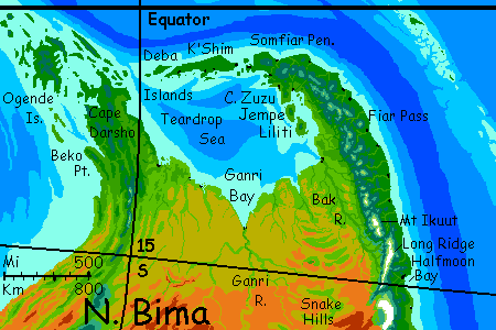
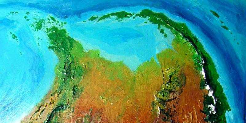
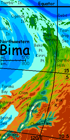
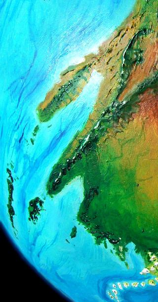
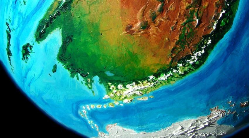
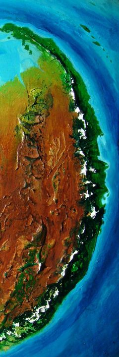
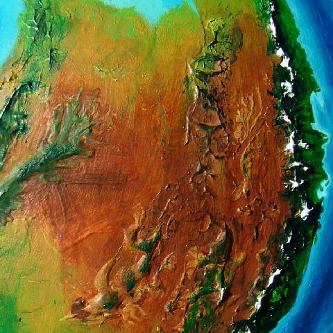
Bima is a large southern continent; at 25 million square kilometers (about 10M sq mi), it's bigger than North America but a bit smaller than Africa.
Like all of Kakalea's continents, a lot of Bima is desert; what's unusual is that over half of it isn't. Why? Just good geographic luck, on a planet where bad luck abounds? Not quite. There's one other continent that's not mostly desert or ice: Iba. And it's no coincidence that Iba and Bima both run north-south more than east-west like other Kakalean landmasses. That orientation means they can't help straying into some decent climate belt now and then! These two continents have nearly half of all Kakalean land in the temperate zones.
Bima has other advantages reducing its desert. 'Vantage number two: its coastline is less regular than lands like Ara or West Ata--both are quite chunky, and, not coincidentally, the driest continents on a dry world.
|
|
I admit Bima's not spidery--looks fat as a panda in the orbital photo above! But the camera's position over the central desert exaggerates its big red belly--and remember curvature, too! That exaggerates its midlife paunch even more. Really that coastline's quite broken, for Kakalea: one inland sea, the Teardrop, and four peninsulas larger than Italy (plus a few Greeces). Coastal deserts do exist--one of the peninsulas is quite dry--but overall, these bites and bumps increase the proportion of land with a maritime climate.
'Vantage number three: Bima's desert is rather mountainous and broken up. On Kakalea, high gravity and thin air make even modest mountains rain-catchers. Terrans generally can't explore such highlands--the air's too thin to be safe--but they are there, adding fertile sky-islands in the deserts, and creating rivers or at least creeks and springs down in the lowlands that you can explore.
We'll tour Bima counterclockwise, starting in the tropical north...
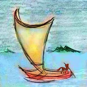
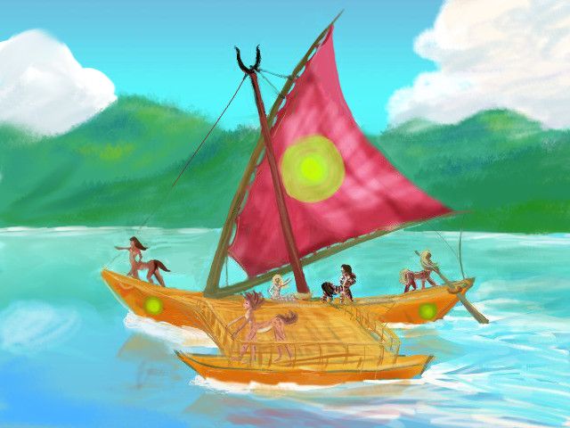
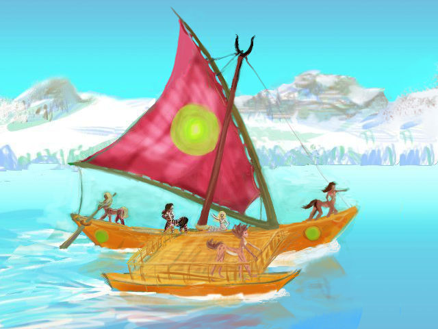
As in most tours of Kakalea's continents, you'll do as the locals do--ride a catamaran crewed by the centauroid natives. While low-tech, these twin-hulled boats are a surprisingly fast way to travel--averaging 400 km a day, up to 600 on a good day. Such ships can circle a continent in weeks. Since civilization here is largely coastal, this is a realistic way to get an overview; and it's how the Kakaleans themselves see their world.
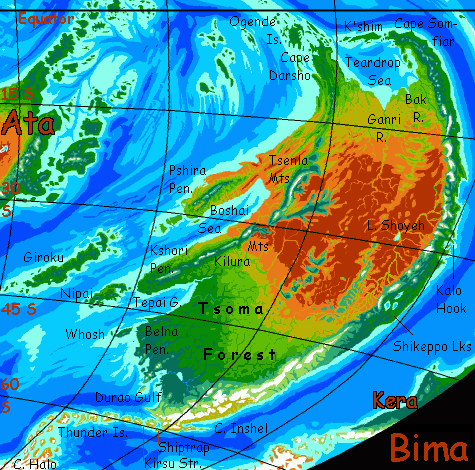
Let's start in the far northeast on that blunt green western promontory, Cape Darsho. About 1000 km long, its forested highlands run inland another thousand km or so--the same green hills march south along the coast above drier lowlands, catching enough rain to be a migration corridor between tropical and temperate zones.
Off the tip of Darsho, the fertile, rainy Ogende Islands lead northwest across the equator to the huge northern continent of Ara.
To the east runs another large island chain, the Debas, including a Java-like island, K'shim, which I expect to be densely populated; it's the most fertile land in northern Bima. So I think our tour will follow the Debas first, on a trading catamaran. After a week (and, I suspect, several paragraphs as yet unwritten), the Debas will lead to the tip of...
Cape Somfiar, over 1000 km long and 200 wide, also clad in monsoon forest. Rugged cloud-capped peaks inland, some of them clearly volcanic cones. Here you either...
The coast eventually veers back west; but now it's savanna just spangled with acacia-like trees. Or, as you now see them, pools of shade. The shore seems vaguely African. It's hot. Relentlessly hot.
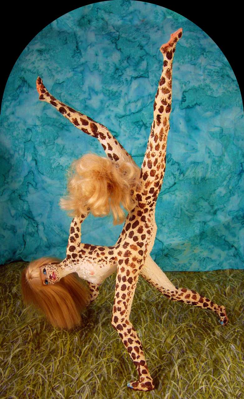
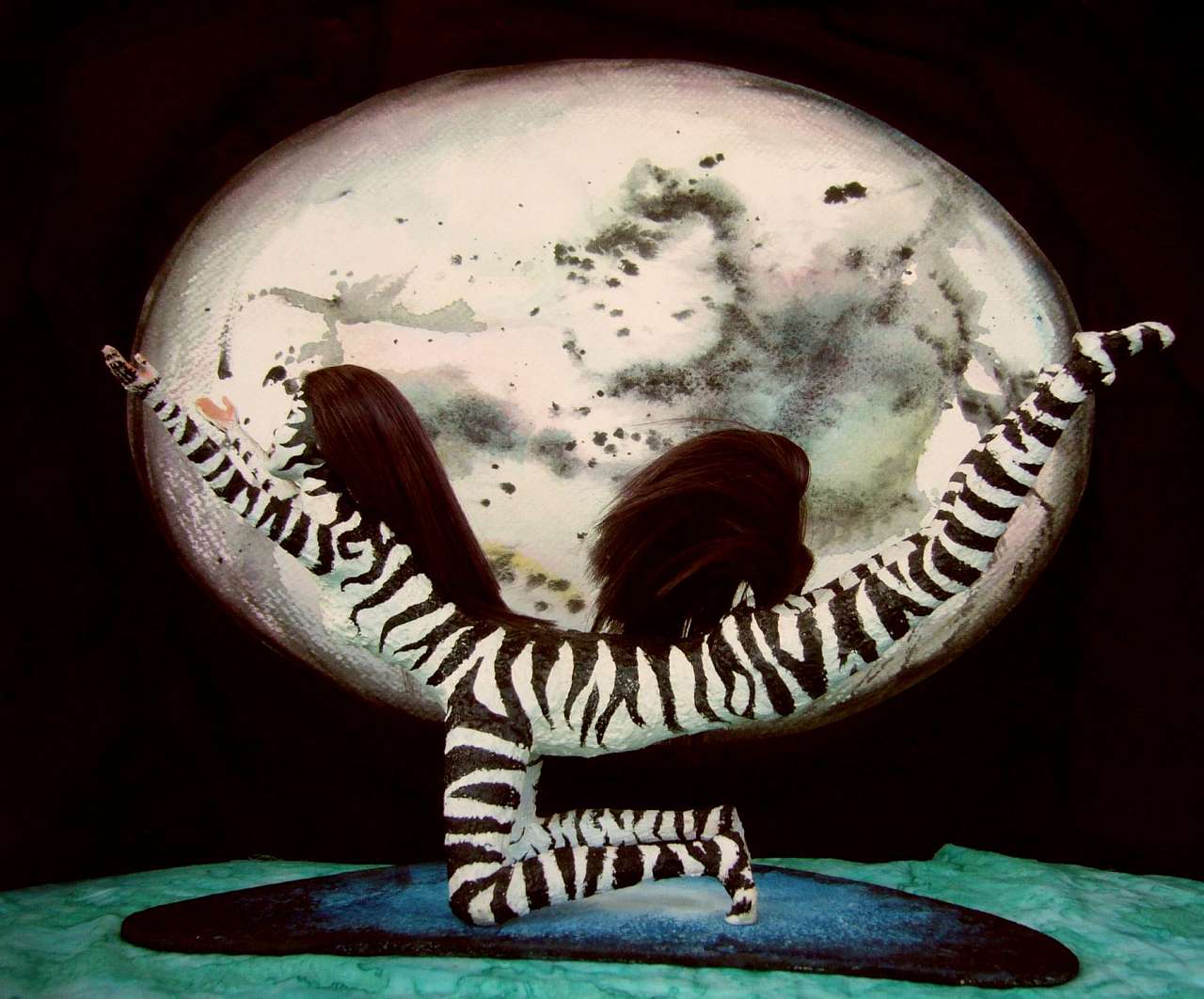
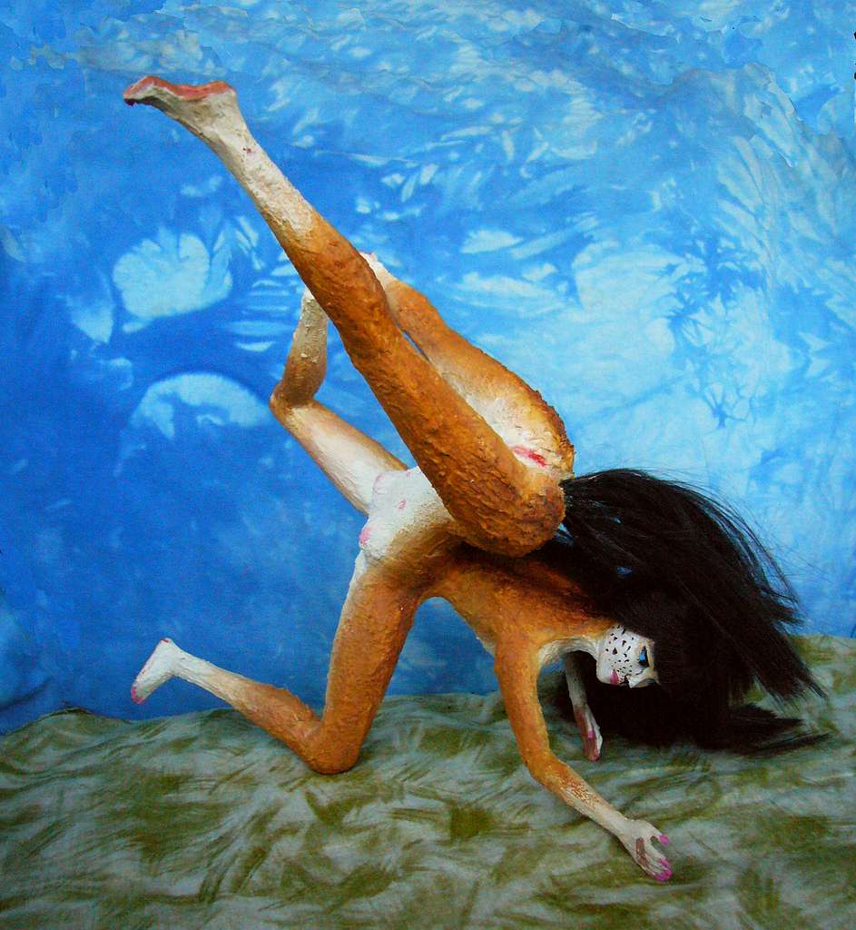
Zara dancing Come on Rain, Fertilize me! |
There's a ferry crossing the Bak River, linking the two halves of Bakport. The river drains the dry inland face of the great coastal range. Irrigated fields fill Bak Valley inland, though the surrounding basin is mostly bare grassy hills and low plateaus.
Tired of sailing? Feel like I'm evading "the real continent" by keeping you on boats? By all means trek the next stretch--it's just 1000 km or so. It'll seem like more! But it's flat--the air's merely alpine, not Himalayan as it would be if you'd tried to go inland on Somfiar or Cape Darsho. You can breathe. So go ahead...
But the wide grassy plains fronting the Teardrop Sea to the River Ganri are, well, monotonous. From the orbital photos, you'd think the Snake Hills (the border of the inland desert, more or less) would be distant silhouettes to the south, but even huge Kakalea's slow curvature is enough to tilt these low ridges below the horizon--they're over 200 km off. No, day after day the horizon's as flat as mid-ocean. No scenery, no shade, no streams. An occasional well. Not the healthiest water...
A dusty gold ocean of dry grass. If you're lucky it'll rain on you. Mud and green new growth, attracting wildlife. And domesticated life. And rain festivals. And dancing and mating.
You know you've come the wrong way when getting rained on is a highlight...
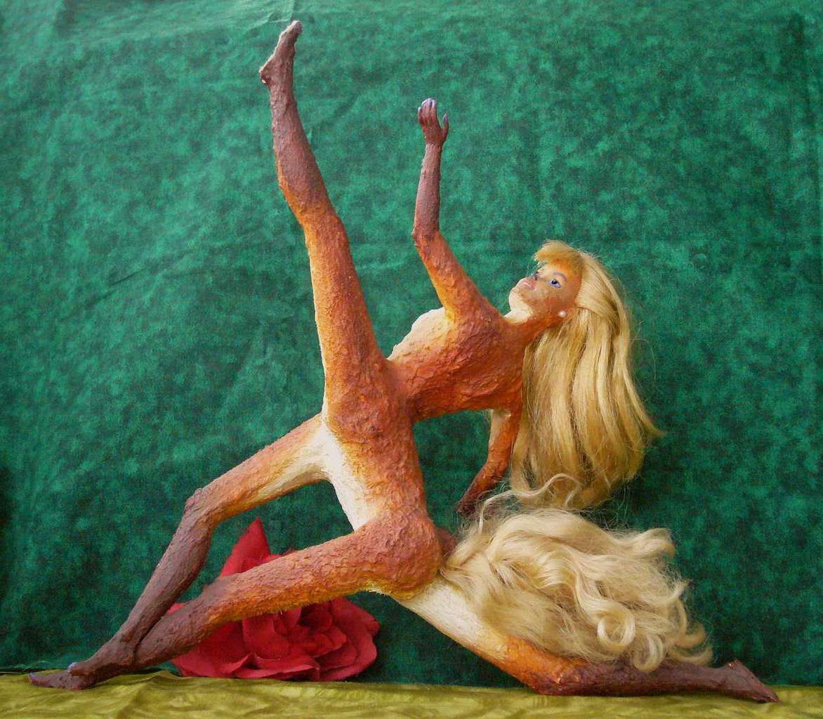
North Bimans are rangy and heat-adapted, with very short spotted or reticulated coats like giraffes. Zara, the dancer pictured, is pretty typical--almost as rangy as a giraffe.
I hope there's a ferry across the River Ganri too--it drains most of the interior. Building a raft would be tedious--so little wood here. But though the Ganri Basin is by far the biggest in northern Bima, a raft is all you need; this isn't the Amazon, or even the Bak. Upstream are dry lands; the flow is modest, the river just 100 yards wide, and shallow too. If it weren't for the pseudocrocs you could swim it. Half the year you could wade it.
But I doubt you'll need to. Port Ganri may be poor, hot, sleepy and small, but it'll be there. With a ferry or bridge. And a harbor. With boats. Tempted?
Now it's just another 1250 km (750 mi) back to the base of Cape Darsho. Flat veldt, even drier, not a tree for shade. Flat until you go out of your mind... Go on, walk.
Starting to get why even the natives would rather sail? They see Kakalea as a collection of coasts, not continents. No local ever called herself a Biman.
Definitely a boat trip again. Some of this land would be hell to trek across...
So you sign onto another, larger catamaran--the Green Sun--sailing down the west shore of Cape Darsho.
DAY 1: Low hills, rising to cloudy heights inland--not that you can see them from land, only from shipdeck. It's unbroken forest, one of the few on Kakalea. Equatorial rainforest. So much for the desert planet!
For the first couple of days south, that is. But around Beko Sound, the forest starts to open up. Glades. Then grassy valleys with groves on the slopes. Why no trees in the bottomlands? Monsoon floods--and droughts, and ensuing fires. Still green, but a harder, moody land.
DAY 3: Hard and getting harder as we head south past Point Kiriri. Open meadows and scrub, mostly, now, down on the coast. Trees only along watercourses. The only forests you see are dim blue patches in the distant, cloudy highlands... a cross between the Atlas Mountains of Morocco and the stony, piny West Sierra Madre of Mexico.
DAYS 4-6: It gets worse. No trees, just scrub and dry grass and boulders. Three days of this desert coast! No surprise why. We're at the latitude of Baja, or Western Australia, or the Namib Desert. It's not the bone-dry Atacama Desert--those aren't the Andes on the horizon blocking rain, just modest hills--but it's sure not friendly. Slow sailing, too. Hot dry breezes at most, some days nearly still air. Your catamaran is highly responsive, more so than heavy European-style vessels, but she still slows to an amble. One day you do a mere 130 km (80 mi)--stunningly bad, by the crew's disgust and worry.
DAY 8-10: For now, from shipboard, what concerns you (and your crew) is: for three days the Olam Desert has not a single anchorage with drinkable water. Streams do descend from the Tsenlas, but they're caught in that washboard tangle of foothills and rarely reach the sea. The Olam is this continent's only large coastal desert.
DAY 11: One more day under relentlessly sunny skies as you cross the mouth of Torima Bay--the only land the bare heads flanking the bay, rusty old sandstone mesas that'd look at home in Central Australia, the last thing you expect next to a tropical ocean.
DAYS 12-13: Creekmouths on coves punctuate the otherwise dry shore. No miracle: cool green mountains rise inland. Little villages at every mouth: irrigated gardens. Life here is hot, but not bad. The fishing's excellent. Most of the year, winds come from the shore--dry, but they push the surface water outwards, and cooler, nutrient-rich deep water wells up.
The green mountains inland are a sign you've reached the Twin Peninsulas, a likely cradle of Biman civilization. Here, long dry summers yet adequate winter rains (well, compared to the lands you've just passed, anyway) make food-collection and storage easy. Surpluses and leisure time. And just like your grandma warned you, idle paws are the devil's playground! (Art and science: diseases of leisure! No wonder totalitarians advocate hard work. For the rank and file, at least. Keep your workers from playing... it leads to thought, and we all know where that goes.)
This drier northern peninsula is called Pshira. Warm Mediterranean coasts below cool green mountains. A somewhat warmer/hotter Greece, or a greener Baja or Peru? Pleasant enough if you live by a year-round creek. And here, unlike the Olam to the north, they exist every ten miles or so; the forests up on Pshira's mountain spine are a sponge feeding creeks even in dry years.
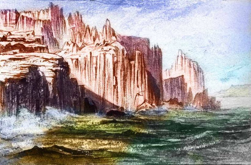
DAY 14: The middle of this Pshira Coast is a strange many-armed bay, Nalu Sound: a complex of curving, dry sandstone heads and fjords (if you can have fjords in a desert). Nalu's scenic, and a huge, wonderful harbor, but fresh water's scarce; the coastal washboard of ridges blocks mountain streams, pooling them into one small river that empties at the head of the sound; the only town of any size.
DAYS 15-16: The outer third of the Pshira Peninsula is distinctly more maritime. Streams reach the sea; the coast here's a patchwork of forest and meadow, fed by reliable winter rains and summer fogs. The gentle weather and subtle seasons have given the local culture a mystical tinge; they're obsessed with "balance" and "centering" in a way that makes you wonder if California hippies fled here and mutated into centaurs. Nope. Parallel cultural evolution, due to similar climates. Balance-obsession and mysticism weren't hippie inventions even in California! Local tribes built little meditation-terraces all over the Coast Ranges, were obsessed with "balancing the world" (possibly to mitigate quakes), and considered places like Mt Shasta and the Golden Gate to be spirit-portals, all for centuries before the European invasion. I'm telling you, it's that weather.
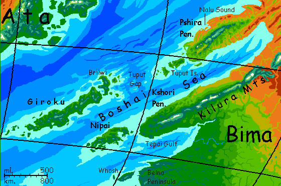
DAY 17: At first you think your navigator is just being cautious, swinging out to sea to avoid that fogbank near Pshira's tip. But at sunset you're still headed out to sea. Time for a long side trip! Off Pshira's tip are the fertile Tuput Islands, running hundreds of kilometers southwest.
DAY 18: This morning your shipmates do some trading in Port Tuput, then blow the embarkation horn at noon. To your surprise the ship heads further southwest. The Tuputs appear to trail off to flyspeck islets on the local chart, but your ship holds course. Near sunset the islands fail and the sea turns dark: the Tuput Gap, over a kilometer deep. (On Kakalea, that is deep).
DAY 19: Only at sunset the next day do the long shadows of heaped clouds ahead reveal your goal. Somewhere, hours off, mountains rise.
DAY 20: You land on Brilwi the next morning. 400 km long, and verdant. The continent's dry heart has little influence this far out, and we've come a long way south as well as west, we're leaving the dry belt. The climate's mild, maritime. It seems a pleasant archipelago.
DAY 21: Next morning you're puzzled again, when your ship heads on southwest between the south end of Brilwi and its halo of lesser islands.
A long coast appears north and west. Giroku! A sort of Japan, but dominated by one big island, and Fujiless--the highest peak is barely 2500 m (8000') and most are under a mile (1600 m). It doesn't take as much vulcanism to raise such an island from Kakalea's shallow sea; on Earth, the whole thing would be deep underwater; not a single reef.
Giroku has a temperate climate, though snows are brief and light most years on the wide fertile coastal plains. For once, Kakalea gets something right! Giroku's densely populated; as many ports on this one island as you've seen on the whole continent so far. Up till now you've been thinking of these isles as overgrown Azores; now you're thinking New Zealand or Madagascar. You should. Giroku's big.
DAYS 22-29: This week is spent in circumnavigating the great island--through Brilwi Passage to the north side of Giroku, west along the north shore, back along the south.
Go to musicals each night. Your crewmates all do. Giroku has a high reputation even among this theater-mad people. Mystical, a little surreal, but also funny, fast-moving and sexy--no concern with balance here! Asymmetry is fine with Girokans, as long as it wiggles--and winks at you.
Hm, it really could be Japan--if you mixed Noh, J-pop and maybe a touch of old Burlesque.
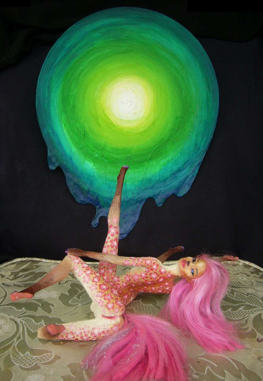
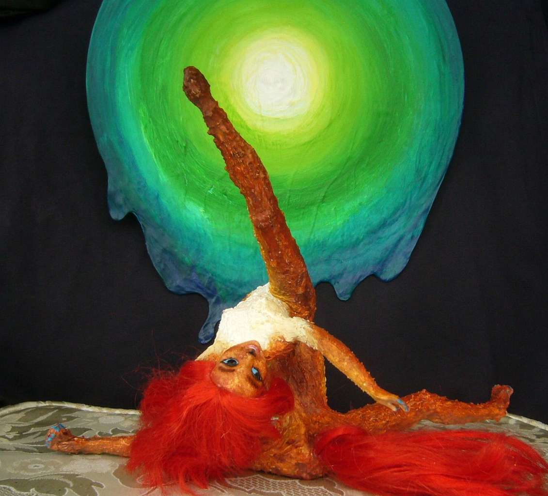
TWIN SHOWS
Two shows you see share the same peculiar set--black backdrop with a huge painting of a melting green sun. But the two dances use it for different purposes. The first, with a large cast, treats the Green Sun as an icon showing how modular language--separate nouns, verbs, adjectives--fosters imagination, by encouraging new combinations--green sun, black light--that are evocative, useful or even, occasionally, true.
The cast, being Kakalean, of course embodies such word-combos as sexy encounters between dancing Parts of Speech.
Curiously, the Green Sun is a Terran icon too. Tolkien (with philologist hat on, not novelist's hat) argued exactly the same thing generations ago in On Fairy-Stories--that modular language, with stand-alone signs for green and sun (as opposed to animal calls bearing useful but complete messages like "unripe fruit", "mate with me", "winged predator alert!") is an automatic fantasy-stimulator. Such languages readily generate myths--and creativity.
These Kakaleans seem to have generated the same cluster of images and ideas quite independently. Nicely illustrating Tolkien's point that language promotes such conceptual mix-and-matching. Green and sun make green suns inevitable.
The Green Sun: Sidera |
The Green Sun: Lia |
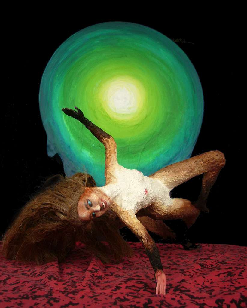
Fuchsia dancing I Made the Sun Come |

The Green Sun: Proni |
The Green Sun: Ariel |
The second show, Fuchsia's solo piece I Made the Sun Come, blending erotic dance--making love to sunlight?--and some sort of seasonal ritual to bring the sun back to this land that sees real winter. Only instead of sacrifice because "the old year must die", as in human traditions (Kakalean centaurs aren't a hunting culture)... it's seduction. Sun, you're so sexy, please come back, please come, come all over me...
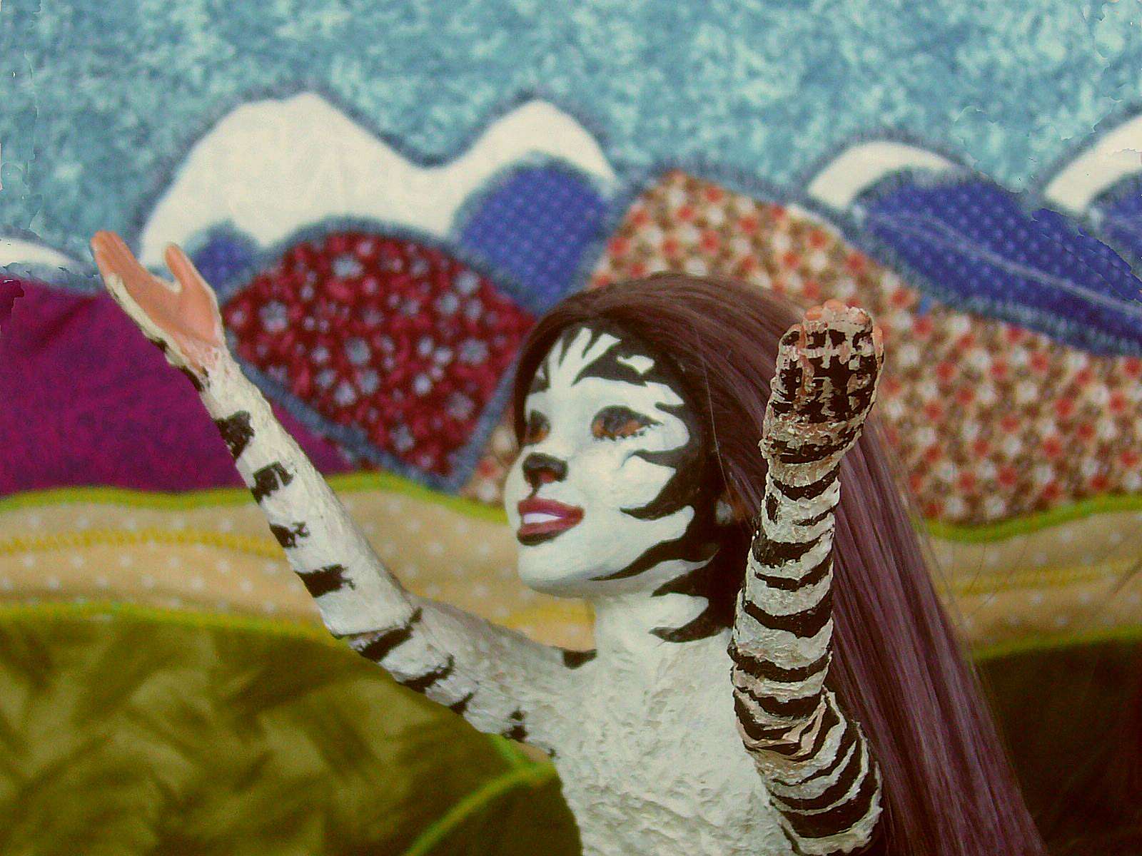
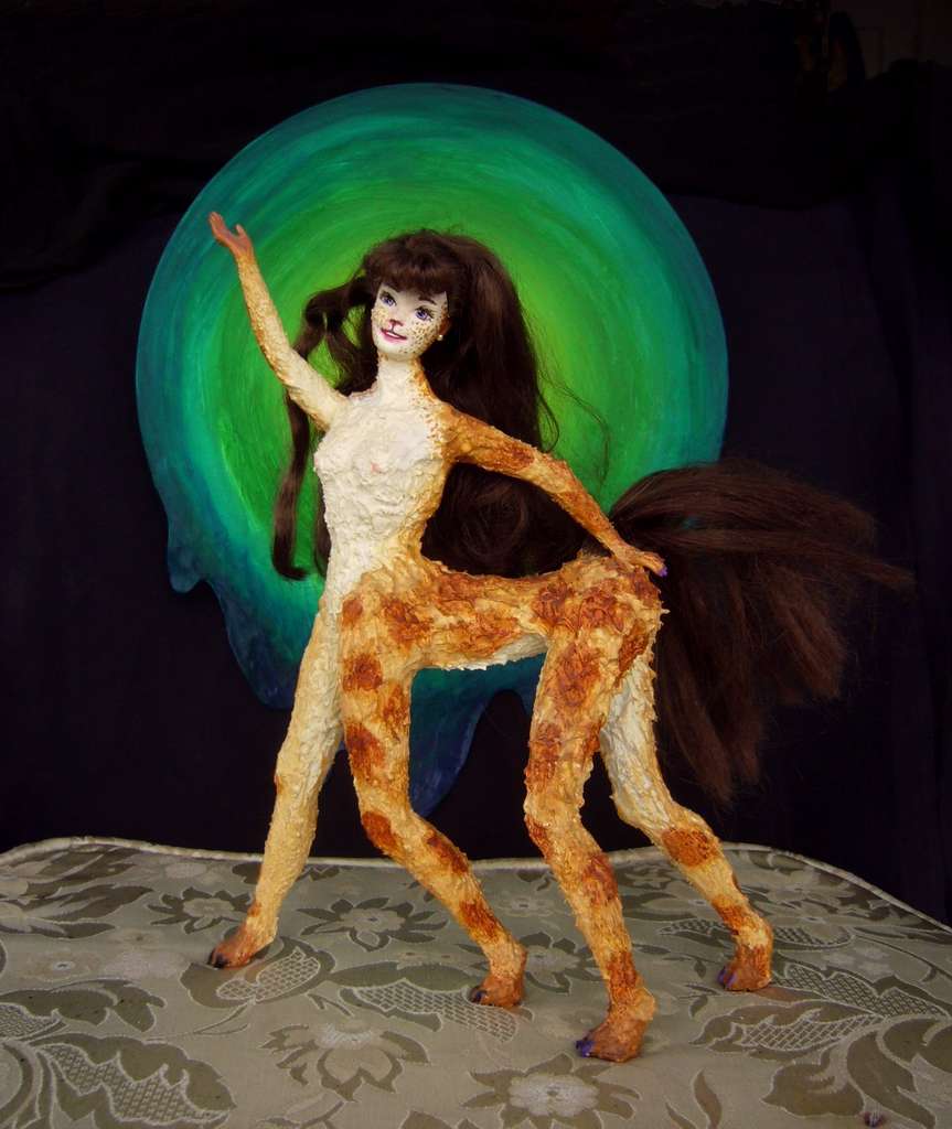
Suplica's natural zebra stripes |
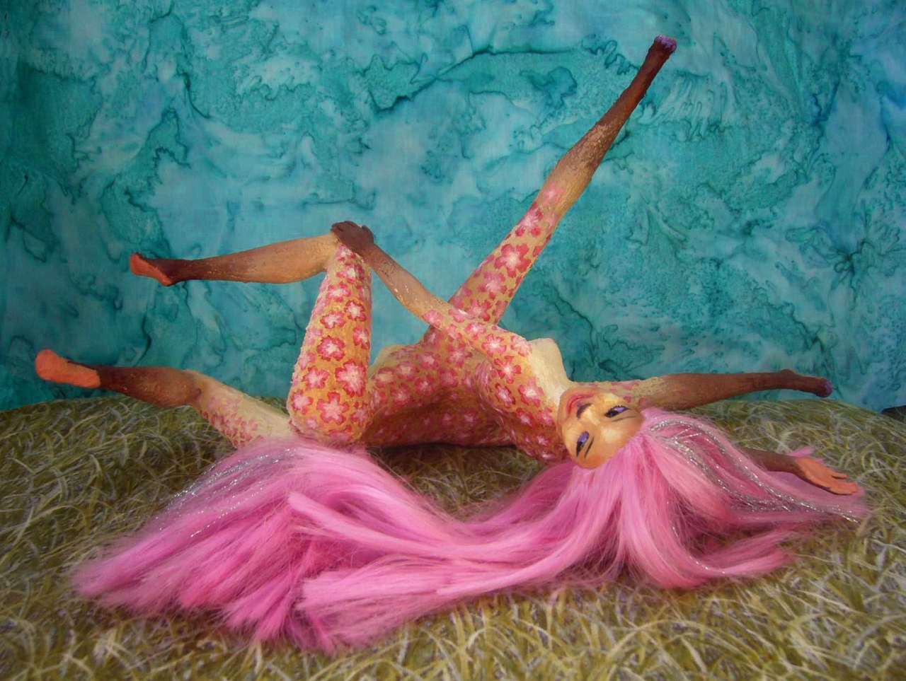
Fuchsia's pink floral dye-job |
Genuinely hot, but you can't help seeing it as satirical too--a comic comment on the excessive pretentiousness of The Green Sun's ideas. Definitely in reaction to it.
But words alone don't create ideas. Syntax matters--the order of words, or images... or plays. You later learn that you saw them backwards! The painting came first and wasn't a stage-set at all; a local artist dreamed the image and painted it. Fuchsia the erotic dancer went to a party at the painter's lodge, liked it... but saw a solar orgasm in it! She built her sinuous dance around that image--sex with the sun, with warmth, with life?
And on seeing that show, some of her friends saw potential in another direction and worked up the metaphysical play. The intellectual structure was built on a sex-dance built on a dream.
And this layered building-up seems typical of the Girokan mind. Maybe of Kakaleans generally.
Not humans, of course!
ON ARTIFICE
By the way, Suplica's zebra stripes weren't a dye-job; that pattern is common in central and western Bima. It's not camouflage; the stripes confuse the hell out of flies and mosquitoes.
But Fuchsia's floral leopard-spots are just as artificial as her striking magenta hair and tail. Girokans like artifice. Though not uniquely; it's true all over Kakalea. Many of the fancier coats you see are dye. Kakaleans generally find clothes hot and confining--they get twitchy and itchy. Dye is a way (along with clipping, and poofing, and braiding) to escape monotony itch-free, and play the fashion game without overheating.
Is it a coincidence that even on Terra, henna, tattoos and bodypaint are more common now, as our weather gets hotter and the T-shirt replaces the suit? Kakaleans, most of them living in hot and sometimes humid climates, have merely taken this to its logical conclusion: don't drape and encumber the body, just decorate it.
Giroku, the Tuputs and the Brilwis, the Twin Peninsulas and one more great island, Nipai, all border and define the Boshai Sea. If you include the outer half sheltered by Giroku and Nipai, Boshai's nearly as big as the Mediterranean, and with a similar climate--a little stormier, as it's less sheltered, but not a bad place to learn navigation before risking longer deepwater journeys. Though even Kakalea's oceans can't match Homer's "wine-dark sea"; just half as deep as our Mediterranean.
In the far north, Boshai's shore is scrub desert--surrounded by dry lands and high mountains, it's hard to imagine where rain would sweep in from. Yet it does now and then in winter, for stormtracks run right up the length of the Boshai Sea. The middle shores are grasslands and groves, opener in the Angeleno north, more wooded to the south. This is why your ship headed so far out; chasing rain, greenery, population and wealth the way fishers seek far-out shoals, skipping the dry inner Boshai shore.
DAYS 30-31: Now you run back east toward the mainland with a mild but steady breeze--somewhere around Brilwi the winds began to strengthen and shift from off shore back towards it. In just two days east-northeast, you reach the mainland and make port in a tiny bay near the base of...
Kshori Peninsula, the cooler, greener twin of Pshira. Here at Kshori's base, the coast is cool-subtropical or warm-temperate: that paradoxical San Francisco nonweather. Open woods, meadows, a complex patchwork depending on fog as much as rain.
DAY 32: Sailing west toward the tip, the balance quickly shifts: woods grow denser and meadows fewer. No need to irrigate local gardens and orchards.
DAY 34: As we near Kshori's tip, dense misty forests line the shore--gigantic trees in fact, like a southern-hemispheric equivalent of redwoods. Yet inland the woods still open out; some glades and meadows. Southern France, northern New Zealand? Oregon might be the best comparison, since the Kilura Range is quite alpine, with long snowy ridges 3-4 km high (10-13,000', and climatically they're higher still; remember the thin air.)
DAYS 35-40: Around Nipai, off the tip of Kshori. Nipai's the size and climate of England--just pare off Scotland and Wales, stock with centaurs... A quick journey along the straight, north shore, densely forested with broadleaves--Southern England? A slow journey through the bays and heads and isles of the cooler south shore--dark woods of pseudo-pine and cedar.
DAYS 41-43: Back to the mainland--the Kshori Peninsula. Along its south coast to the head of Tepai Gulf. Relentless deep green onshore. A huge forest, for arid Kakalea. But small compared to what's ahead...
Rainy winters here. Rainy summers too. Did I mention rain?
Well, sometimes it gets sleet. Or blizzards. But not often. We have South Bima for that...
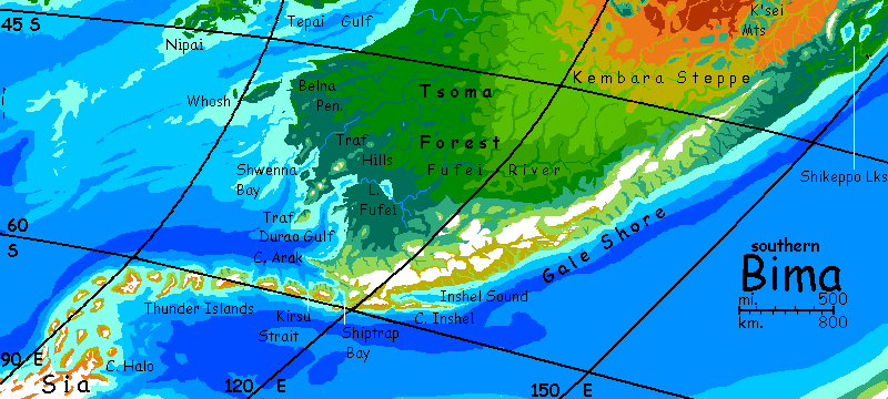
South Bima is Kakalea's nearest thing to a Europe--a smaller, antipodean one, but the resemblance is there. Past Cape Kshori, Bima is a vast temperate plain running raggedly into the sea--Tepai Gulf, Belna Peninsula, the Isle of Whosh, then Durao Gulf and its many capes and bays. It's all deep green--storms track deep inland, unimpeded by coastal mountains--low hills at most. The result: Tsoma Forest, stretching perhaps 3000 km along the coast and up to 2000 km inland! Some narrow coastal strips are longer, but Tsoma is the largest forest in the world in area and biomass, by far.
But it became clear to me that whatever their lineage and appearance, the odds are that Kakaleans will have evolved on savanna like humans, simply because Kakalea has so damn much of it and so little forest. If so, it's likely they'd bring their sun-loving crops and gardens with them, as well as that instinctive craving for sunlight. So it's likely we'll see at least some clearings in the great wood, as in Europe.
And in any case, the woods do fail inland, as all Kakalean woods do--eventually. It's just ten times further inland here! And the Biman prairie, Kembara Steppe, is greener than most, for hundreds of kilometers at least. This isn't dry African savanna, as in the north. Here, winter normally brings snow, though the cold season's short; and the growing season extends not just through spring, but summer too. Wild thunderstorms. Tornados! Kembara's really quite Missourian--and then Nebraskan.
But all backwards. These prairies grow steadily more arid to the north and east, not the south and west as on America's high plains. Eventually, even the Biman prairie fades into the central desert.
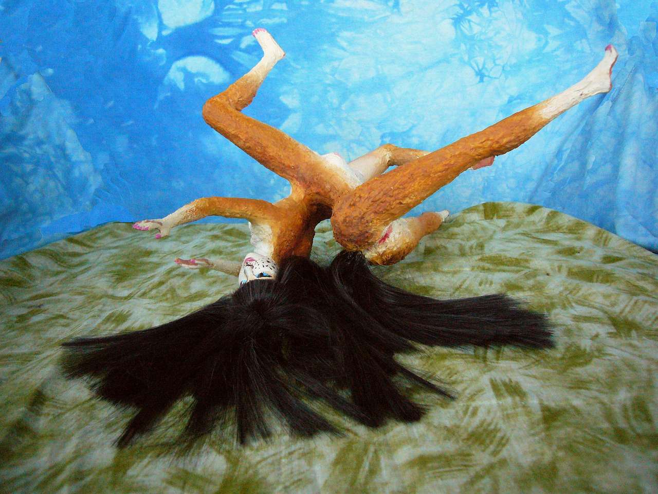
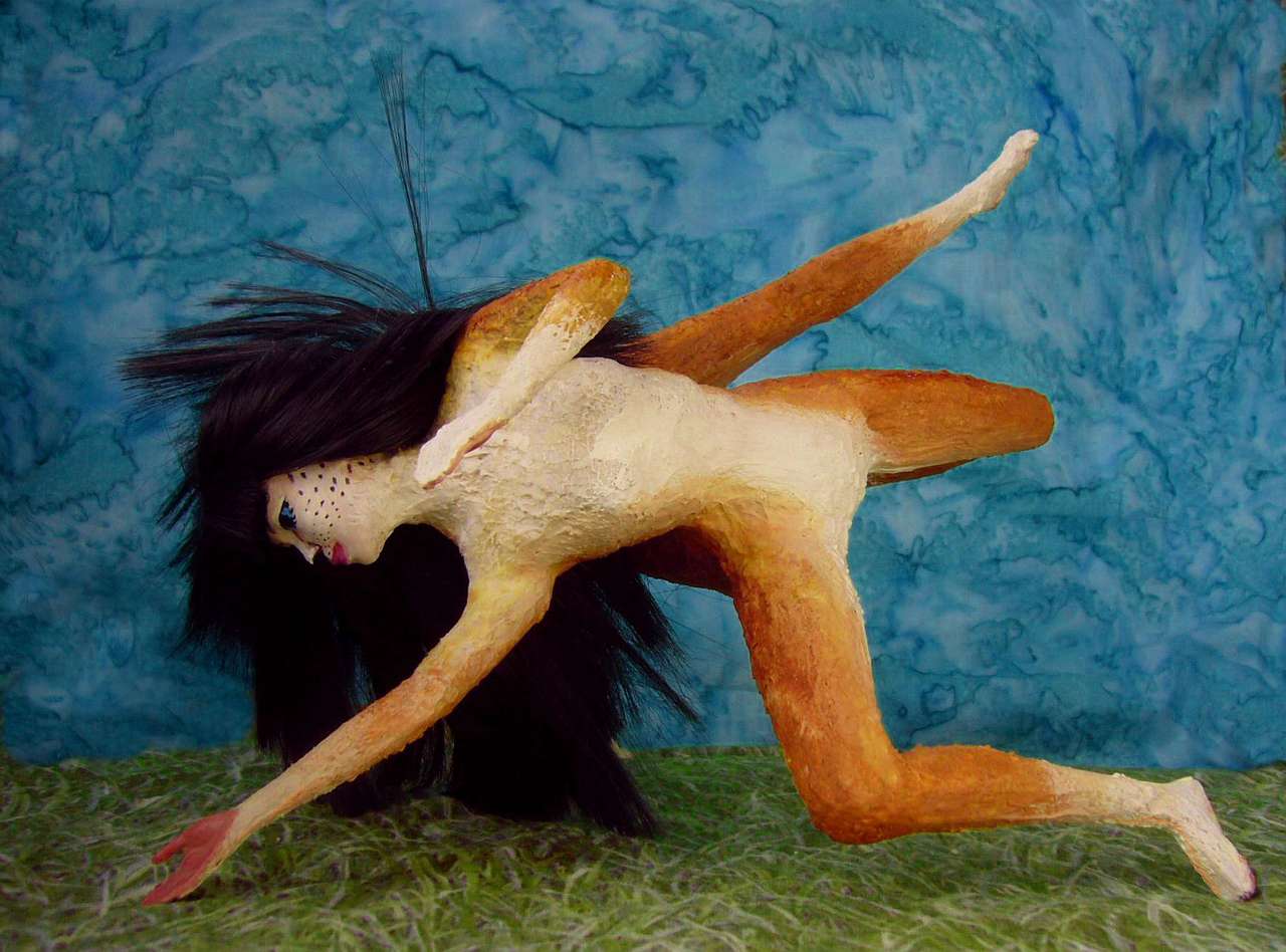
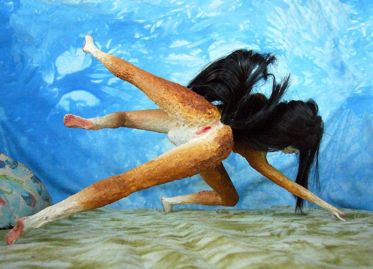
Though the people aren't Nebraskan. Proverbially hot-blooded. Here's Nila, a native Kembaran, in her signature dance The Black Fan
| ||
|
|
|
| Nila of Kembara dances The Black Fan as performed in Lakeport, Fufei River, Bima | ||
Eventually, perhaps, this great plain will force me to break my convention of circling each continent, exploring almost exclusively by cruise ship. It's justified on most of Kakalea: impassible mountains and desert flats inland. But not here. I'll have to figure out a way to take you inland around Tsoma.
I guess we could loop around Tsoma on stagecoaches. The region has Kakalea's only regularly scheduled land-transit system, modeled of course on much commoner ferry and riverboat systems. Roughly modeled. Very roughly. Bumpily, muddily, tardily modeled. Expect to wait. But you'll often wait pleasantly--in music-inns, a universal institution in Tsoma.
We'd probably do faster to ride with a mail-and-package caravan. Mail-order is popular on the prairie and in the wood; printing here is primitive so catalogs are too costly for individual families, but even the smallest community has a library, whose four most popular reference books are the annual catalogs of the four rival mail-order firms... three of them headquartered on the coast of course, though the newest centers 200 km (gasp!) inland, on Lake Fufei.
Or perhaps we can follow a theater troupe wagon-looping through the great hinterlands, bringing the season's new plays to the unwashed. Because there are enough unwashed here, in wood or on open prairie, to support a thousand traveling shows. And it's not all one-way; not with this population base. That troupe will be looking for new talent and collecting new ballads and scripts, too. The one place on Kakalea where innovation comes, at least now and then, from land not sea. Nila and her dance came from a Kembaran farmstead. Her passion and dynamism contrasts with the static artifice you saw in, say, work from Pshira or Giroku the way their gentle rains contrast with a prairie thunderstorm.
Well, for now let's just assume that we've made that slow, muddy, bumpy trip from Port Tepai across the Great Unwashed to the Fufei River and back to the coast--and the relative speed of catamaran travel.
Snowy winters along this coast--irregular and brief on the Belna Peninsula, Shwenna Bay, but south of the Traf Hills, around Durao Gulf, snowfall's reliably annual and can get deep some years. But the soil's fertile, the growing season pretty long, and these inlets abound in fish and edible seaweed. Despite the snow, these peninsulas are good places to live--little Brittanies and Denmarks.
In the far southeast: high mountains, icefields and alps/tundra. Great herds of caribou-equivalents. Of course they may be lizard-taurs or flightless birds with small foreclaws to pluck vegetation while their heads stay up watching for trouble--nearly all Kakalea's megafauna build on that six-limb chassis, not four--but whatever their appearance, they'll have thick insulation and eat grass, bracken and (in the far south) lichen. Ugh, bitter. But there's not much else to eat.
At the southern tip of Bima is an island arc, the Thunder Isles, leading to Cape Halo on Sia, the south polar continent. But this tongue of Sia isn't quite Antarctica; we're further from the pole. Sheltered valleys and north-facing slopes on the Isles and the peninsular tip hide tussocks of grass. Sea birds by the millions. Colonies of burrowers analogous to pikas. Even, on the northern half of the chain, small "caribou" herds. Though perhaps feathered or scaly. With hands.
DAY 1: you book passage on the only catamaran you can find that's heading up the east coast, the Green Sun again. Most traffic from Tsoma goes north and west; but the Sun plans to circumnavigate the continent. She's a large stout vessel twice the length and ten times the tonnage of the spidery little cat you sailed around the tropical Teardrop Sea. As you'll soon learn, the reason she's so big and solid is on this leg of your voyage. The English word for this far-southern climate is 'temperate', but its seas are anything but.
You set out from Port Fufei heading west into Durao Gulf, like everyone else. But as the gulf opens south, the other catamarans all veer southwest toward Traf Strait and Bima's west coast; your ship reaches almost due south along the eastern shore. Low dark-wooded hills; two deep inlets, almost fjords, winding a little so you can't see the ports at their rivermouths; just their traffic.
Midday, the cat angles further offshore to round Ching Head, that long ridge before you. Afternoon: south now over deep water; the shore recedes. This half of the Gulf, Durao Bight, has only small ports your crew voted not to bother trading at.
Yes, they vote. Kakalean catamaran crews are cooperatives, not captained hierarchies. True, the shift on duty will rush to obey the pilot and steerswoman; at up to fifteen knots, a cat sails far too fast for debate. But strategic decisions, as opposed to urgent evasive maneuvers, are group affairs.
DAY 2: you round Cape Arak and enter Kirsu Bay. Southeast now, several hours. It looks pointless--you're heading straight for shore--a mountain wall, in fact. Your crew heads straight into a fjord between two icy volcanoes. The cat goes slow and warily here--the passage is deep, but rocks loom and the wind gusts. And we need the right branch; like our Straits of Magellan, Kirsu Strait isn't simple.
That icecapped peak to your right isn't part of Bima but the first of the Thunder Islands, reaching a good 30° west, then hooking south to Sia, the polar continent. Don't even suggest following this route to the crew. Brrrr! Besides, you can't trade with hexasheep.
Anchor for the night at Port Kirsu. You don't need supplies yet, but your steerswoman wants news from vessels coming the other way. Bima's southeast coast is notorious for storms.
DAY 3: the Kirsu Strait opens slowly into a great bay. East! Rounding the blunt head, a bare shoulder of great ice-cloaked volcano above you to the north, you wonder if this lava flow is recent, for it's treeless. But then all this coast seems curiously barren after the misty woods behind you.
Ahead: more ice-caps march northeast, gleam on the horizon. You can see hundreds of kilometers--the mists and looming clouds are gone. The forests, too. Winds here blow off the polar ice. Though you're no farther south than Kirsu Bay was, it's another world--gale-blasted, desiccated, exposed. Those great peaks shelter Tsoma from these winds.
Your cat crosses the mouth of a great bay between peaks--it looks like it too may lead back to Tsoma Wood. Saddles look lower and broken. A second, easier passage? Why didn't we take it, save a day? Well, no. The Shiptrap has fooled many Tsoma-bound navigators coming the other way. On! Your cat stays well offshore.
DAY 4: a narrow, stony, barren coastal plain at the foot of jagged peaks. Behind them miles of continuous icefields gleam deadly white. The cat charges along at 25-30 kph (over 15 knots), slashing through great foam-topped rollers that tip the outrigger--a hull nearly 20 meters long, weighing tons--right out of the water, to slam down again with a crash. Antarctic Sia's icecap generates such stiff, steady gales your ship's in danger. And not just from wind and wave: shallows. Lesser volcanic vents that the relentless sea ground back into mere reefs.
Some of the crew--the skinny, the short-pelted, the colts--actually put on cloaks. Well, half poncho, half horse-blanket. Now that you've been on Kakalea a while, these crudely clothed figures are almost as startling as naked people on a subway would be on Earth. Kakaleans don't normally need clothes, being quite furry and living in generally warm climates; nor do they like them; they feel itchy and encumbered. But itchy is better than collapsing from insidious hypothermia. The wind's not freezing--just endless.
DAY 5: some relief, though it doesn't seem so at first. All morning, the mountains have dwindled. At last, a gap opens. Fjord or strait? Your steerswoman nervously guides the cat through the passage; it soon opens into (somewhat) more sheltered waters: Inshel Sound. The hills you've just threaded through are now revealed as a mere spur. The main range looms on the horizon to the north, perhaps 200 km away--still quite visible, with their great height, the cloudless air, and Kakalea's low curvature. It's a big world. You've rounded Cape Inshel, a 500-km peninsula running parallel to the shore, 1-200 km off it.
The cat heads for the mainland; near sunset you anchor in a cove on a less barren shore. Grass tussocks, some even green not yellowed and dry. Low brush in cracks, by stones. The land's almost Patagonian, but life seems to have spread a good ten degrees farther south--polewards. On Kakalea, geography generally explains why things are worse than on Earth. Not here--and our history's why. Some of Patagonia's barrenness (and Labrador's, and some of southern New Zealand's) is a temporary legacy of our recent Ice Age; the land's still recovering from even harsher times. But this Biman coast was never permafrosted, ice-scoured or blizzard-blighted; it's greener than Earth at the same latitude--as much Prairie as Patagonia.
As Earth's subpolar barrens will be in time. Not even deep time; mere millennia--and not from human changes. The Earth we think of as pristine and endangered by global warming is still scrambling to cope with the end of the Ice Age! Global warming already happened. Is what we see now a normal baseline? Only if you think a hangover is sobriety!
So this coast, though windy and treeless, has a near-continuous grass cover, and what streams there are all reach the sea. "I have seen the subarctic future, and it works!" Buy land in Labrador, I guess. Before the rush.
DAYS 6-7: you sail northeast past cool dry grasslands. Neither too cold for trees nor too dry--it's the combination, in that steady wind off the icefields inland, that keeps these hills bare. No towns; not even villages, really. Over this entire 1600-km stretch (1000 mi), the only signs of habitation you spot are an occasional cabin by a creek and two threads of smoke inland. Herders, miners? On Earth, such land--no worse than Alberta--would be settled, if not densely. But Kakaleans evolved in heat; they just hate that wind.
DAY 8: trees huddle along creeks and in hollows. So do the fishing villages--the first you've seen. As we pass 50° south and head for 45, the winds grow bearable. Rainy springs, summer thunder, sunny falls, winter blizzards. Patchy pine woods on the hills now.
DAYS 9-10: forest. Evergreen the first day, but next morning, a few pioneer broadleaf trees join the mix--brighter greens and golds. Small towns all day, and then on the second evening... a broad delta with mud bars and marked channels leading inland to Lakeport. The Shikeppo River is the only one on this coast big enough to be navigable by deepwater ships. Here the coastal strip is as wide as it ever gets, over 300 km (nearly 200 mi); low parallel ridges shelter fertile bottomlands around the Shikeppo Lakes.
A large, prosperous region, though with strong seasons: cold winters and muggy, rainy summers. After your long subarctic passage, Lakeport seems a great city. Its people have a jaunty, confident style. Maybe it's that changeable weather.
This scene shows the stylized representationalism of the region's art: literal mirrors for the three lakes, simple sawteeth of fabric for the ubiquitous evergreens, great sheets of torn paper for the surrounding snowy peaks. The dancer is typical of the region: neither shorthaired like most Kakaleans nor wolf-shaggy like most of the temperate-zone minority, but patchy--smooth except for a curly mane along the spine, poofing out at hips and shoulders. It looks much like a Terran poodle, but it's natural, not a hairstyle. Quite practical in this cool climate: keeps head, spine and the hip/shoulder joints warm while keeping limbs free. And it resists matting down in the rain.
I did mention the rain, right? Lakeport gets more than Seattle. Winters can turn bright and cold, but spring and fall are soggy.

DAYS 12-13: a long straight coast running almost due north now, not east. Farm-clearings and woods. Small ports with poor shelter. Luckily the weather's fair! Well, not luck; your steerswoman spent some time contemplating southbound ships' reports back at the Shipping Office in Lakeport, and decided it was safe to run inshore.
Slowly the snowcaps shrink from knee-high on the mountains to waist-high; the forests, no longer dark evergreens, shimmer in the breeze. Farms. The sun actually warms you. Like sailing south from Massachusetts to Delaware...
DAY 14: past Open Bay, a large, safe harbor suffering from cultural and commercial eclipse. Bima's east coast has the bad luck to have its three best harbors all in a cluster. If Open Bay were a few days north or south... but it loses out to its even better neighbors. Too bad it wasn't situated along the Straight Coast a few days ago, where it's needed.
Oh, well.
DAY 15: the twin harbors of Choru Bay, sheltered by long Kalo Hook, and Tirai Bay to the north, protected by Zimaku Island and the Hook. Kalo Hook, fronting on both bays, is likely to be a great port city; this long straight coast offers few harbors to rival these. Forests and meadows; winters do get cold here, though snow down on the coast is rare now.
DAY 16: you round blunt Cape Zurnekki. Suddenly the weather warms. North of the Cape, a warm current flows close inshore; the woods are lush, broadleaf and subtropical. But this isn't, say, Carolina. Inland, floating on the horizon, you still see white fangs. Though the coastal range is fully 200 km inland here, it's also 3-4 km high--quite high enough to be visible. A little reminder this is still a mere green strip; as is usually true on Kakalea, desert lies beyond.
DAYS 18-19: north along the Chorlata Gulf coast. Here the sea laps the foothills; the coastal plain is gone. Jungle to ice in a glance!
DAY 20: Cape Jinnu juts southeast, ending Chorlata Gulf. As you round the point, the coast runs north-northwest. The white peaks of the Coast Range recede, are nearly lost in the western haze for a day.
DAY 21: the hovering white phantom of Long Ridge, an icemantled wall over 4 km high. The green shore below recedes, forming Halfmoon Bay. Balmy. Puffy clouds bring relief from actual HEAT.
Port Halfmoon is a large, pleasant city, with more open architecture than you've seen. Trellises and flowering vines where other cities have walls. Not surprising in this warm humid climate. Wide eaves on the conical roofs, mimicking the mountains on the inland horizon--though they're practical as much as esthetic. The wide eaves create light outdoor spaces still usable in the frequent rains--an antidote to Seattle Cabin Fever.
DAY 22: your last snow, high and distant: volcanic Mt Ikuut. Don't try to get close. Even the passes here are all over 2000 m, with air as thin as at 6500 meters on Earth--over 21,000'. But if you could climb to the summit and peer inland hundreds of km, you'd see endless grass. Dry grass, except the green banks of the Bak, fed by snowmelt; but at least the plain's not desert. The influence of the Teardrop Sea! Monsoon rains, short but intense, and unpredictable thunderstorms feed this savanna. The Teardrop is a reason Bima has less desert than most Kakalean landmasses.
DAY 24: the coast is a steady green wall of forest, almost jungle, rising to cloudy peaks. If you were to trek inland through the mountains (and this is the first place you could cross since Kirsu Strait) you'd reach Fiar Pass, at 1200 m (4000'; air pressure equivalent to 5500 m or 18,000'). Beyond, to the southeast, you'd see a great plain--green here around the mouth of the Bak River, thinning to treeless savanna upstream to the south. But to the northeast, coral shallows--the beginning of the Teardrop Sea that makes the savanna possible. From here on, though you can't see it back from your catamaran, you're following the shore not of a continent but a great peninsula, Somfiar.
DAYS 25-27: the coast slowly bends west. On Earth, Cape Somfiar would be an island arc; on Kakalea, it's an unbroken mountain wall. But over three days, the heights dwindle from cloudy if not snowy giants to low and broken jungle hills. Even warmer. The seasons here are Floridian: muggy versus muggier. Hurricanes in summer.
Oh, well.
DAY 28: the coast recedes south and breaks up into islands. We glide into Land's End harbor, at the tip of Cape Somfiar. To the west is the Cuba-like Isle of K'shim; to the south, the Teardrop Sea.
Bima's coasts, considered as a whole, are the usual Kakalean hodgepodge--from barren to quite fertile. Quite average. The miracle lies inland. Because the continent stretches into temperate latitudes most Kakalean continents don't, much of Bima's interior, despite harsh continental climate, isn't desert: In the north, Teardrop Veldt's the second largest in the world (after Kurin Savanna in southwest Ara), and in the south stretch the forests and steppes of Tsoma, a pseudo-Europe.
Even Bima's desert is more varied than most. Four major mountain chains break it up:
- WEST: THE CHOKKA HIGHLANDS
The Chokka is a strange Y or V-shaped highland so far inland, and so high, that trade and transport to the coast are difficult. Most Kakaleans don't consider the Chokka a coast range at all, though geologically it's a clear link between the Darsho Mts to the north and the Pshira and Kilura Ranges to the south. Though the two arms are linked, they're different:
- The higher western Tsenla Range has rather Mediterranean glades and meadows on its slopes, then conifer forest higher up, then extensive alpine meadows, then icy volcanic peaks and long ridges up to 5000 meters.
- The eastern arm, the Chokkas, are a little lower, topping out at 3-4000 m (10-13,000'), but broader in area--no glaciers, lighter snowpacks, open pinelike forests and stony meadows sprawling across rolling highlands. The Chokkas trail off into the central desert--indeed, this arm of the upland is near the geographical center of Bima.
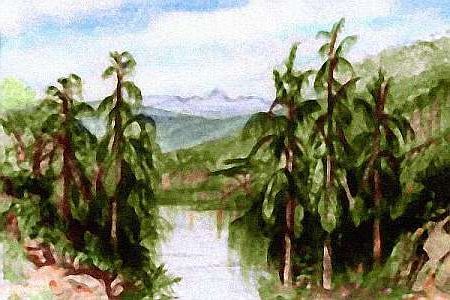
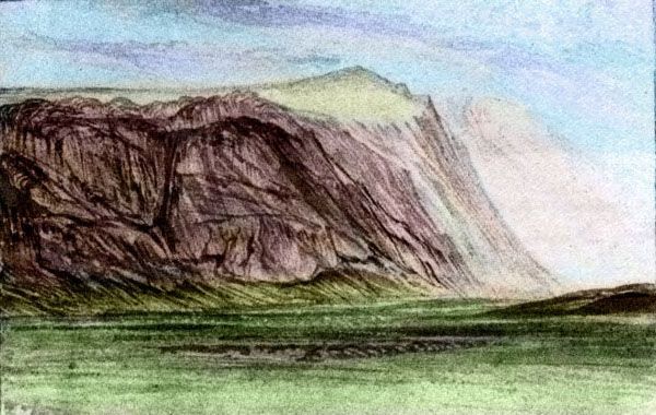
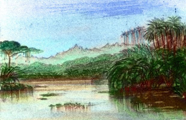
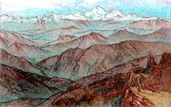
Below is a paint-sketch of the ragged end of the Chokkas from the edge of Ganri Basin. Though not spectacularly fertile, the Chokka Highland is high enough to avoid the ovenlike heat of the central desert, and it snags enough rain to be livable. Plus, the highland streams run hundreds of kilometers into the desert; several north-running creeks merge to form the Yok River, which flows all the way to the Teardrop Sea instead of dead-ending in a salt lake like so many of Kakalea's inland rivers. The Yok's unnavigable of course--whitewater as it descends, then shallow stony and braided as it crosses the flats--but it's drinkable and (being mostly snowmelt) reliable. The Yok and its branches are safe caravan routes making much of Bima's western and central desert accessible.
- NORTHEAST: SNAKE HILLS
Scalloped ribs and lava flows (many branched, tubular caves; cool places to live, in both the aesthetic and climatic sense). The crossribs of the Snake Hills face the Teardrop Sea and snag enough clouds blowing in to support brush and some trees. Few year-round creeks, but waterpockets and springs in the stony canyons. Dry, harsh, but livable herding country if you'll do the work of digging wells or lugging water from springs.
The basin just to the east, the Bak Valley, is true desert--low barren flats. But down the middle runs a Nilotic oasis: the Bak River, which collects snowmelt from a hundred creeks off the high eastern coastal range. Irrigated fields.
- SOUTHWEST: GORLAI RANGE
Volcanic, basaltic, black; old lava flows form twisting ridges and curved mesas, though all but the rawest are covered now by open pine forests. Heavy winter snows. Like the Chokka, but harsher for farming. Herders do well; Terran cowboys would find it familiar. Except that the herders here don't ride horses; they gallop around on their own four paws.
- SOUTHEAST: K'SEI RANGE
The only one southerly enough and high enough (4000m/13,000') to support glaciers, though they're small. Conifer forests and even alpine meadows: like a splinter of the coast range to the east. The coastal range slumps a bit here, too, letting some blizzards in; it's as if the tectonic force for upheaval has here been split for a few hundred km. The valley between, the Shoyeh, isn't even desert, but dry grassland, though downstream it sags back into high desert, then alkali flats around salty Lake Shoyeh. Wyoming to Mojave in a few day's gallop.
LISTS AND LINKS: More worlds? Planetocopia! - dreams of other worlds - ecology - climate change - evolution - natural disasters - terraforming - sculptures and 3D art -
World Dream Bank homepage - Art gallery - New stuff - Introductory sampler, best dreams, best art - On dreamwork - Books
Indexes: Subject - Author - Date - Names - Places - Art media/styles
Titles: A - B - C - D - E - F - G - H - IJ - KL - M - NO - PQ - R - Sa-Sk - Sl-Sz - T - UV - WXYZ
Email: wdreamb@yahoo.com - Catalog of art, books, CDs - Behind the Curtain: FAQs, bio, site map - Kindred sites