Kakalea:
IBA
by Chris Wayan, 2012-2015
Kakalea basics--map--geology--
creatures--
Building Kakalea
More worlds? Planetocopia!
Kakalea:
IBA
by Chris Wayan, 2012-2015
Kakalea basics--map--geology--
creatures--
Building Kakalea
More worlds? Planetocopia!
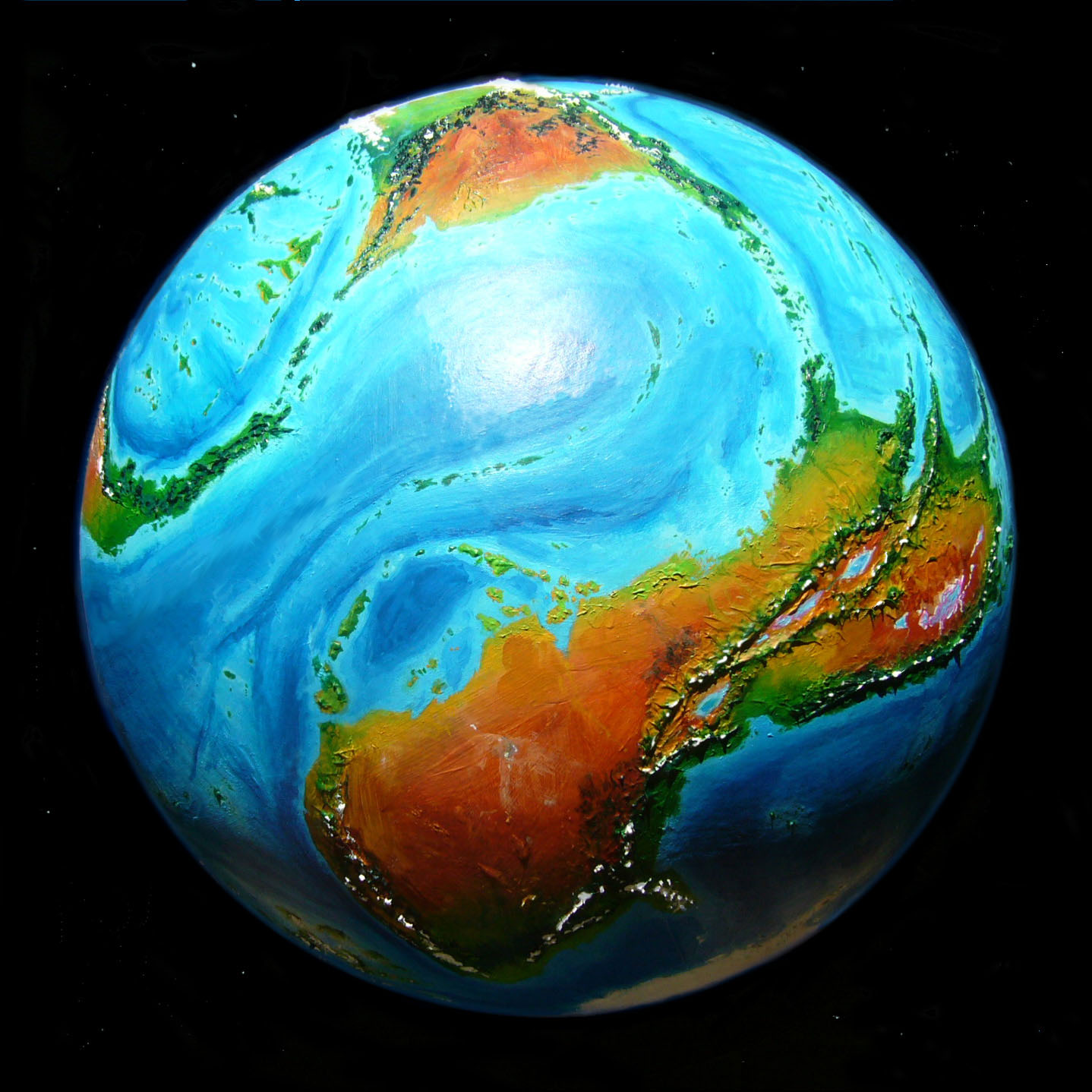
Think of Iba as South America turned upside down. Not flipped, though, rotated. Does this matter? Oh, yes. Iba's much drier. Its equivalent of the Andes, the Tlai Range, is on the windward side; instead of broad rainforests and pampas with just a narrow western Chilean strip of deserts and Mediterranean climate and Nordic fjords, we have wide deserts, Mediterranean coasts, a miniature Europe and Scandinavia in the north... and only a narrow humid strip along the east coast.
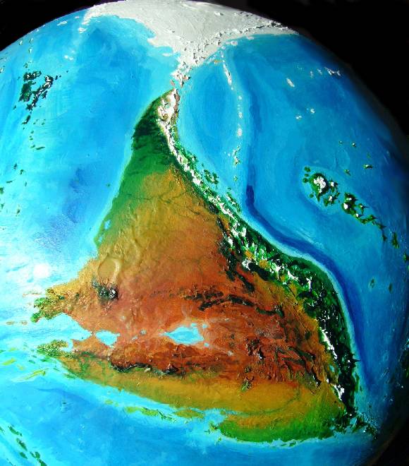
With exceptions! In the far north, Cape Arei resembles our Patagonia in reverse. At fifty north winds roar relentlessly from the west; in our Patagonia, this means storms drop their rain on the narrow side of the peninsula--the forests of Chile are rich but right up against the mountains, while the dry plains downwind of the Andes are broad.
In contrast, the Tlai Range hugs Iba's east coast; the wetter western plain is quite wide. Cool forests, dwarfing and thinning near the tip of Arei to taiga and bogs, then cold prairies (not true tundra; the ground's not frozen). This forest is smaller than Alaska's, but still one of the larger chunks of boreal forest to be found on Kakalea. Not a whole Sweden perhaps, but at least half. Plus a few Denmarks for change.
Up here, the reversal benefits the land. Too bad that's the only latitude where that's true; elsewhere it's a bad deal. And the north is the narrowest and least populated part of Iba's coast. Not the least populated part, period; that, of course, is the central desert, as it is on every single Kakelean continent!
Still, the geological parallels with South America are close--and it's not just Iba's wedgy shape and South American size. All the way from the Patagonian tip to the wide tropical coast, the climates are South American too--just in unfamiliar proportions. Tiny coastal Amazonias, huge pampas and Patagonian steppes, monster Atacama Desert...
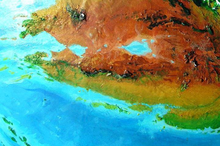
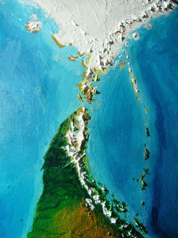
Speaking of size and proportion... seen from high orbit, as here, against the curve of the globe, Iba looks smaller than South America--more a triangular Australia. But remember Kakalea's larger than Earth, fooling the eye; Iba's actually a bit bigger than South America, about 18 million km2 (over 7M sq mi). Two Australias plus a Western Europe!
Despite all that desert, there's room for some green.
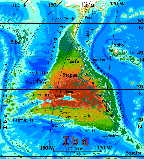
Iba's east coast, like that of most Kakalean continents, is a long fertile strip; mountains wall it off from the deserts to the west. It's the biological and cultural heartland of the continent--a sort of coastal Argentina-plus-Brazil.
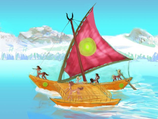
As on many such regional tours, we'll be sailing on a midsized catamaran. Kakalean shipwrights build small--not that much timber, overall. Cargoes are light. But cats are fast--this one does over 25 kph (14-15 knots?), adding up to hundreds of km a day.
So a typical voyage here isn't years as in Terra's great Age of Sail, but weeks or months at most--and you're rarely out of sight of land. On Kakalea's shallow, island-speckled seas, almost every cruise feels Mediterranean or Caribbean.
Well, this cruise doesn't--not at first. The sea, up at this unfriendly northern end of Iba, is speckled with islands, but half of them are white and drifting slowly around. Grinds and groans. It may be spring by the calendar, but not up here, not for weeks yet.
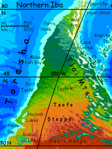
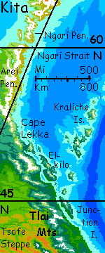
We're starting in Ngari Strait at the tip of Arei Peninsula. It's nearly as harsh as Labrador; for hundreds of kilometers the shore is treeless. Port Arei is no more than a village with a few small warehouses on a mile-wide bay south of the Strait.
Still, it's not as barren as it looks right now. The locals tell you "In a month or so, those snowpatches and mudholes and mats of dead grass will be meadows." Stony, windy, but very much alive.
We run south along this thawing shore. The next day, your first scattered low trees. Stalks rear their heads through snowbanks.
Two more days south and the coastal bluffs are mud with a haze of faint green--seedling grass. The hills beyond are a rumpled blanket of dark pseudofirs (I told you, cats are fast!) rising to still-snowy heights inland.
Small ports at every creekmouth now. Fish, seaweed (Kakaleans can digest their algae better than humans can) and of course lumber. And mining--those mountains are young. Metals and gemstones.
Lekka Port, your first true town--long docks in a sheltered deepwater sound. A full day's rest--for you. Restocking for the crew. Though that, you notice, involves lots of shopping, flirting, drinking and singing in the ubiquitous music-inns.
Out again at dawn--back north a couple of hours, round jagged Cape Lekka, and southeast through the cool, wooded isles of the Inland Passage. We're in middle latitudes--50-43° north--yet it looks much like Alaska's Inland Passage, some ten degrees further north! At high latitudes, east coasts have harsher weather--no question about it.
Rugged Elkilo Island, some 500 km long and up to 250 wide (300 by 150 mi), blocks the dry, cold winds and winter blizzards from the northeast.
On Elkilo's lee shore, and across the channel on the mainland too, tall forests rise--much richer and more diverse than the low windblasted woods behind you. Safer sailing, too. Ports grow larger. Gardens. Architecture. Theater!
It's almost New England, except for the snowy volcanoes floating on the horizon, east and west.
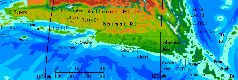
We pass Junction Island, where the 3200-km (2000-mi) chain of the Kraliche Islands runs due north--an island arc like our Aleutians or Kurils--wooded at the south end, windy tundra in the middle, ice at the end by the polar continent of Kita.
Let's not go and say we did. The voyage south is just starting to look promising!
Instead, let's just hang in the cafes and theaters of Port Junction, and people-watch. Quite entertaining since they're all naked.
But not very naked. Folks here are shaggy. Most Kakalean centaurs are heat-adapted; rangy build, short pelt. They need to be. Not here! Only on a few subpolar tours like the Tsufa Archipelago have you seen truly furry Kakaleans. These are.
One variation you've never seen before resembles a cross between Shetland pony and a poodle, with a huge frizzy mane not only on the head and down the neck, but in similar poufs round the shoulders, the forequarters, hindquarters and tip of the tail.
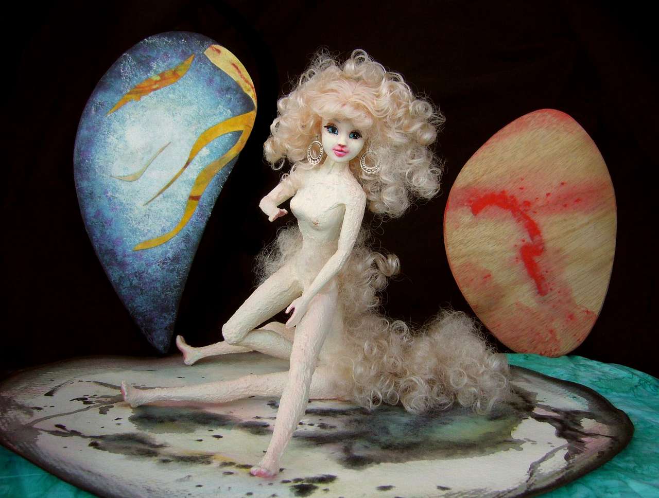
Here's a local actress-singer, Dlana, in a cabaret in Port Ell...
Our catamaran's course veers further east now, along a temperate shore called Aledai, fertile and densely settled. Strong seasons here--white and bare-treed in winter, lovely in spring (though it comes late), muggy in summer, gold and red in fall. Orchard country.
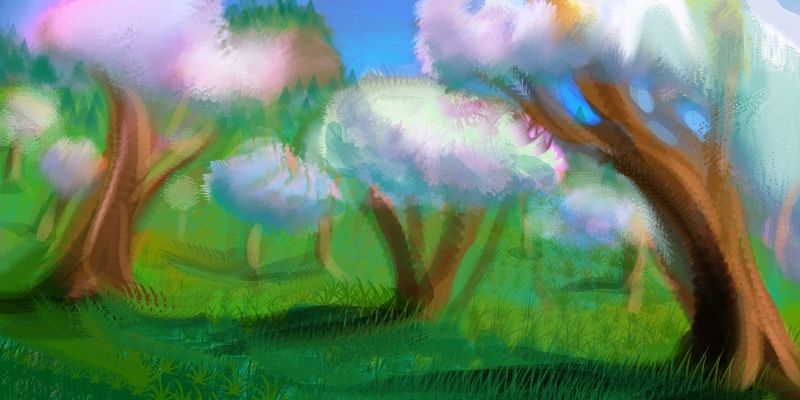
Here's a fast paint-sketch of the pseudocherry blossoms in the Aledai spring...
But Aledai's not North America's east coast. It's a classic Kakalean coastal strip, just a few hundred km deep. Ecologically, it's as much of an island as Honshu or Britain. West over the snowy Tlai Range, so high you couldn't breathe, is the inevitable inland desert. More mixed than most--the Tlais aren't a simple wall here, and high desert and even prairie basins nestle between sky-islands for a thousand kilometers inland. Hard land, but habitable. And scenic, and uncrowded. Appealing to a certain sort of hard mind. But all things fade--after that's another thousand (and more) of dreary dry windy steppes, greening again only near the western shore.
Oh, well.
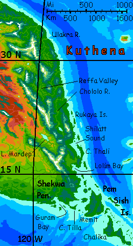
Around 36°, the coast bends south. At Port Ulakra we enter a long subtropical and tropical strip called Kuthena. The Ulakra Valley seems just a warmer version of Aledai--the lower reaches have snowfree winters (and stickier summers).
The Reffa and Chololo Valleys, though further south, are inland and higher elevation, so they seem merely Appalachian--hot summers, cool but snowless winters. But Port Reffa and Port Cho, only a few days' sail south of Ulakra, feel Caribbean, or at least Floridian.
Lia singing It's Hot but I'm Hotter |
Here, singing in a cabaret in Port Cho, we meet Lia, a singer from the northern Morla Isles. Why's she ten thousand klicks from home? "I just got tired of cold, pines, fog, fishermen, sleet..." Every planet with long-distance transport has snowbirds, I guess.
Lia's quite a good singer, but trades on her exotic appearance too; she's as foreign-looking to the short-pelted, gracile, heat-adapted Kuthenans as a Viking would be in Haiti. Though it's not skin color--Kakaleans are highly variable--it's pelt length. Unless she had it all shaved close, her naturally shaggy coat will forever mark her as a Northern Barbarian.
And gives her tacit license to get away with a lot, I suspect...
The southern coast of Kuthena--Rukaya and Chilatt Sounds, Cape Tholi, Lolim Bay--is positively Colombian or Venezuelan. Lowland jungles getting summer hurricanes, mountains with cloudforested flanks but sunny shoulders above the clouds and peaks so high they're still icy, though we're just 15° from the equator now.
Inland is a fourth great valley, the Mardep, drier and opener than the coastal ones; Lake Mardep has no outlet and is slightly brackish. At 1200 m (4000') the basin is pleasantly Mediterranean rather than steamy like the lowlands. But being cut off from the sea is a great disadvantage for trade and culture; caravans instead of shipping. In fact Mardep is off limits to human tourists; the lowest pass is nearly 2300 m (7500'): oxygen equivalent to Earth at 6700 m (22,000'). Kakaleans have big lungs, of course, but even for them such passes aren't comfortable. And this is the easiest crossing of the Tlai Range!
Mardep Valley's not alone--several grassy or even wooded basins lie over the mountains--but to coastal Kakaleans they're as distant, mythical, and exotic as Samarkand was during the Age of Sail. And as inaccessable. There's a reason these Kakalean tours are cruises. Civilization here is littoral, and not just because that's where the rain is. Oxygen, too.
In the far southeast, the lush Shekwa Peninsula has a huge island chain, the Pem Sish, linking it (for those with boats; straits up to 50 km / 30 mi wide) to the Numa Islands and the continent of Fika to the east, and the lush Greenland-sized Isle of Suma and the continent of Tua to the south. The Pem Sish and the Numas are culturally Suman, but the very first island out, Memit (and its hundred offspring) is more Iban. Well, Kuthenan; no one's an "Iban"! Home is your coast, not your continent.
As you head west from the isles and sounds of Cape Shekwa's almost Indonesian maze, the south coast straightens and slowly dries a bit from dense forest to open monsoon woods.
Two days out, the shore breaks up into long islands; behind them is Kireri Sound, 500 km long but just 50 wide (300 x 30 mi). Your ship comes about. For the next few days she'll ply this inland passage, stopping at small towns on isle and mainland. The inland hills look green, but that's their seaward face; inland it's hundreds of km of ochre grassy hills with trees only along the stingy creeks.
For a full day after leaving Kireri, the central-south coast runs straight and dull. The woods slowly open to grove-and-meadow country; we're creeping north a degree or two. And at this latitude, that matters; as if we sailed from rainy Sierra Leone up to dusty Senegal.
Well, not quite. Not yet.
Next day the coast suddenly ends abruptly at Cape Shurani. Our catamaran veers starboard, though warily; the lookout hoots constantly as we thread a course north through shifting mud- and sand-banks: the Shimai Delta. Slow going. By next evening, though, we're in the main channel, and spot the lamps of Port Shimai. Our cat glides up and ties onto a slip lit by the last red shreds of sunset. A warm night, but then they all are here in the muggy Delta...

West of Port Shimai, you can say Senegal with no qualifiers! Up the Shimai River is a tree-dotted savanna as big as Senegal or Syria or Somalia, bounded by rugged mountains to the north. Their slopes catch the sparse rains and sustain scattered trees, even open pinewoods on the heights, but beyond, to the north, is only the central desert.
Why so much drier on this coast? Here, the south shore retreats hundreds of km further out of the equatorial rainbelt--the monsoon rains are much briefer, lighter, and less reliable. Most of the year, the hot air rising along the equator, having dropped its load of rain there, slips north, cooling and drying high in the stratosphere, to descend around 30° north--creating a chronic high pressure zone over the central Iban desert. There are places here it never rains!
The shores of Shimai Gulf and the Koro Peninsula still have groves and scattered trees on the plains, and year-round streams, but those are the last we'll see for a while on the mainland. Out west it's open savanna even on the coast, with few trees except along the seasonal creeks--and inland it's just dry grass to the horizon.
Overall this swouthwest savanna plain is unexciting, but we'll take a side trip inland to a couple of curiosities.
We'll have to transfer to a 'flat cat', a tiny, shallow-draft catamaran, to sail up Tet River at the base of the Koro Peninsula to Tetek Crater, the largest impact scar I've found on Kakalea. Takes all morning going in against the current, sluggish though it is--the Koro coast is pretty flat. Except ahead. From outside, Tetek looks like a huge flat-topped mesa some 500 meters high (1600').
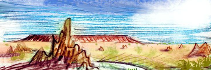
But hike with me, despite the heat. Up that tawny grass slope between the muddy termite mounds. Your guides of course galloped way ahead, out of sight; Kakaleans on foot are as fast as Terran cyclists. But eventually you grumble and puff your way to the crest... and the land falls away in a near-perfect ring almost 29 km (18 mi) across. A shallow brackish lake 3 km wide (2 mi) lies at the low point. No outlet, of course; it'll take eons to breach this formidable ringwall.
120 km to the west is a second crater, Shaki, just 16 km across (10 mi). They seem equally unweathered and are almost certainly part of the same event--a chain of asteroid or comet strikes.
How old is the Tetek complex? I'm not sure. Erosion is slow in this Mediterranean climate; rains are mild and ice is inconceivable. It could have survived many millions of years in good condition. Based on the meteoric iron found below the crater floor, what slammed into this coastal plain was a lump of mostly nickel-iron, not silicon, carbon, or ice. Given that density, the bigger rock was probably just two km across, the smaller just one.
That's still big enough to ignite a continental firestorm. But then, south Iba hasn't got much to burn. "When you ain't got nothin', you got nothin' to lose." The poverty of the land may have, in a strange way, protected it.
No doubt the twin shocks caused a tsunami that flooded this coast and the low north coast of Tua to the south; and the world must have suffered a dim, smoky, summerless year or three; but the catastrophe was just too small-caliber for a worldwide extinction.
By the way, Earth suffered such an impact-tsunami quite recently. A rock rivaling Tetek's hit the South Pacific just a couple of million years ago; the tsunami would have been worldwide. But do you see any sign of it? Neither did geologists. Any traces were hidden by the slower rise and fall of the sea in the cycle of Ice Age and Interglacial. Only when Eltanin Crater was discovered buried in abyssal mud off Chile did we even notice we'd been hit.
It takes a really big impact to affect life for long. Even Chicxulub, at least 100 times the mass of Eltanin or Tetek, may not have killed off the dinosaurs 66 million years ago. If vulcanologist Gerta Keller is right, it really was mostly the Deccan Traps spewing carbon and sulfur dioxide. The dinos were poisoned in the parlor by Colonel Basalt, not bludgeoned in the Yucatan by Miss Meteor!
(Though my pet theory is that the impact provoked the monster eruption in India. Shockwaves from an impact don't spread and thin forever; Earth's not a plane but a ball. On the far side, they re-converge. Not just a theory; we see it on Mercury! Chaotic terrain just opposite the site of the biggest impacts. Shockwaves tear mountains apart. Back in the Cretaceous, India was within 1000 miles or so of the convergence site opposite Yucatan. Amazing coincidence, this near-record eruption right around the time the Deccan suffered an inconceivably huge quake.)
The only ecological lesson I see is that Iba, if it was scorched to the ground just five or ten million years ago, looks no worse than other Kakalean landmasses. Life resettled quickly--within the harsh limits imposed by the lack of rain here.
Confession time! By my own rules (I must treat Kakalea's physical globe as a given, a world I must explain) I have to report these craters--but I didn't build them to spice up the tour or teach you a lesson. Like any good crater, Tetek's a true child of chance--a couple of paint bubbles that burst, I think, rather than scars of anything hitting the globe while it was drying. I discovered them only later, when mapping the area in detail.
I wouldn't intentionally build impact craters--not on Kakalea! I'm trying to show you an eco-poverty rooted entirely in geography, not catastrophism, and impacts like Tetek undercut that lesson. But here it is--a catastrophic exception. I'd feel dishonest if I tried to hide it--or smooth it away.
Besides, the locals are proud of their scars. "I survived the Tetek impact!" the T-shirt would say... if they wore T-shirts. Or anything.
Wait, they do wear hats. Sunhats. And now you know why so many locals have those odd-looking straw hats--rather like a royal circlet or tiara. They're not knockoffs of a golden crown--Kakaleans would giggle at the crazy idea of royalty. Nor are they effective sunshades; the brim's not quite wide enough.
But they are pretty good effigies of crater walls!
So buy a souvenir crater-hat and wear it with pride. Every centaur in the hemisphere will know you've seen Tetek.
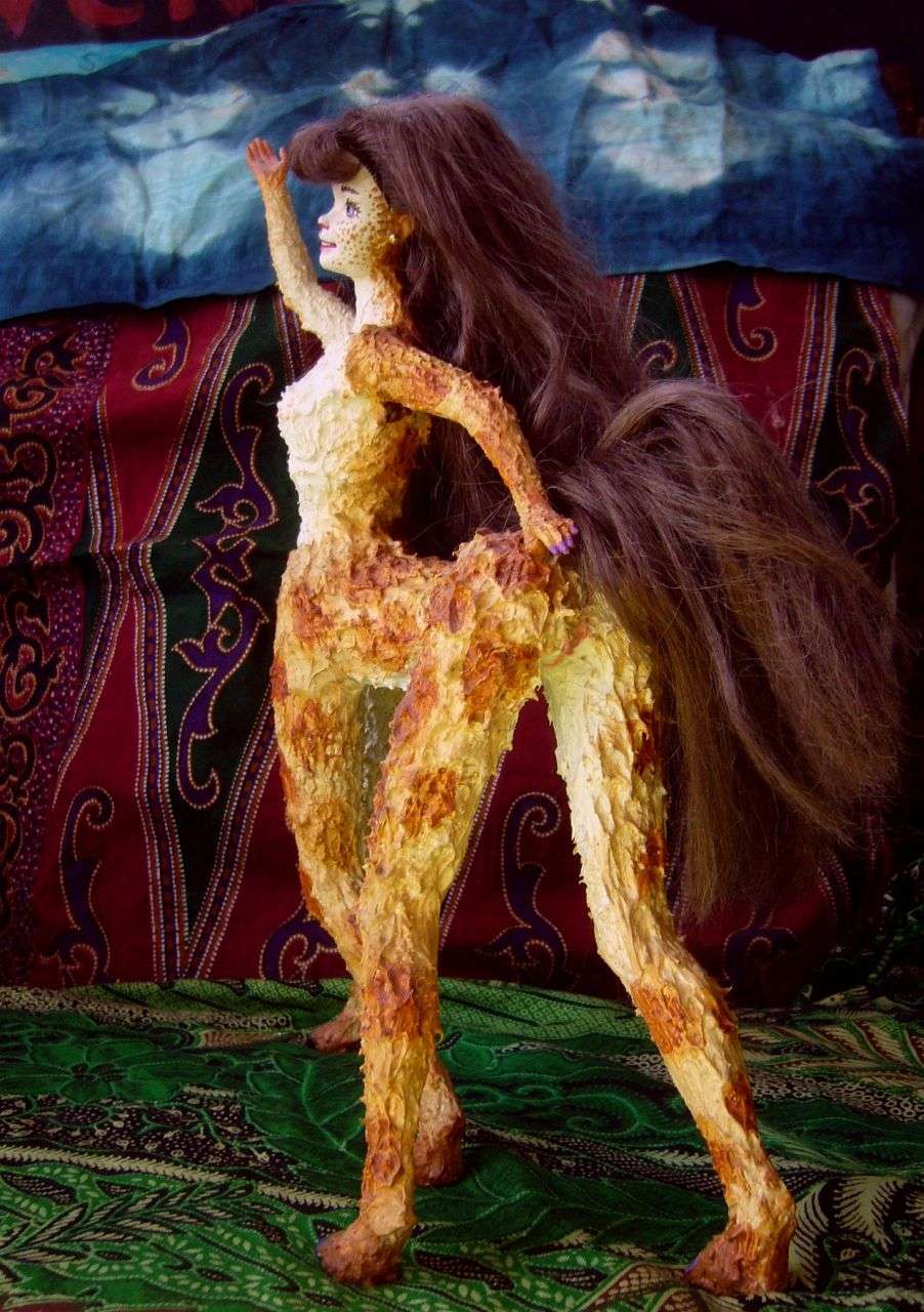
The other sight on this southern strip is much younger--just a few millennia. Less of a climb, too--just a hot dusty walk a few miles from Nautilus Creek, a western arm of the Tet. Called the Nautilus, it seems to be a shrine from a civilization long gone. This life-size carving of a Kakalean nautilus, cleverly done in marble whose colors were chosen to mimic the natural coloration of local nautilus shells, has stood on a savanna flat for unknown centuries.
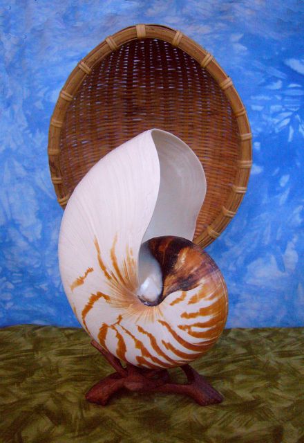
At present it's a modest tourist draw--a mere side-trip to Tetek Crater. It's something of a mystery since no other carvings in this style have turned up in the area, and not for lack of searching. The rattan canopy is recent of course, but folklore (and the oldest sketches we have, going back six centuries) suggest it replaces a similar structure. Post-holes around it hint it's always had such a canopy; it's not some piece of statuary looted from elsewhere and abandoned here by nomads.
What's it mean? I don't know. Modern Kakaleans don't either, though some think they do. A few tourists come and camp by the nautilus, trying to trigger an advisory dream, like the Asclepian temples of the ancient Greeks. Their belief is plausible enough; Kakaleans have always used the nautilus a symbol for dreamwork they way we still use two snakes winding round a staff as a logo for medicine--that dates back to Asclepias. Their symbol makes sense: the multiple chambers stand for individual dreams, and the slow, cumulative spiral growth echoes how dreams bring you round to old places, but with more awareness now. This closely parallels Jung's model of dreamwork--or Yeats's "gyre" model, for that matter.
But there's no hard evidence that the Nautilus was used as such a dream-temple--the custom's probably a recent invention. If you call eight centuries recent. Kakaleans do, but they think long.
The image you see isn't the actual carving, of course, but a stage-set in Port Shimai from a musical in which a representative set of pilgrims come (think Canterbury Tales with music) and have dramatic advisory dreams (one features a famously eerie aria by the Goddess of the Shell).
It doesn't hurt anyone, and does promote tourism to the region by spreading this tale of the purpose of the shrine. True or not.
To save time, money and weight (the production it was made for is meant to travel by boat around Iba; floating theaters are common here), the makers substituted an actual Kakalean nautilus shell (yes, they get this big, 150 cm or 5') to stand in for a surprisingly realistic carving of a nautilus shell.
It's hard to deny it's a surprisingly realistic image of the surprisingly realistic image.
This, on Kakalea, is Authenticity.
A chain of long narrow Mediterranean islands, the Rao, parallel the southeast shore, part of the same ridge that formed Cape Koro. The largest, Rao Koi, is nearly 1000 km long though never more than 160 wide (625 by 100 mi). Nearer the equator and further from the desert, the Rao get more rain than the mainland, so they're distinctly more fertile--and more populous. Trading ships take the inland passage and zigzag between mainland and island ports--a bigger, slower version of the game they played in narrow Kireri Sound.
We sail on for days--Rao Sound is far larger than Kireri, and even our fast cat takes a full day to cross each time. Low hills, little ports... No high snowy mountains on the inland horizon--just savanna forever. Or so it seems. But in truth this coast obeys Kakalean law! The Rakshu Mountains are just a good 500 km inland, quite invisible from here, but 2-4 km high, walling off the desert. Be grateful they do. Without the mountains, this savanna would be grim. The Rakshus are the source of shallow rivers nourishing these ports; and in winter, the mountains block bone-dry winds bringing dust storms full of alkali from the Tselang Sink, well below sea level. Not pleasant country! "Good fences make good neighbors", saith almighty Plod.
Over a week of this zigzagging, with little to see most days but a patchy green shore fading behind your, long hours of white cloud and blue water, then a low patchy green line ahead of you, a frenetic sunset hour of piloting and docking, then long hours of bargaining (and drinking, and dancing, and sex, and of course theater--all Kakaleans are mad for theater).
Repeat. Repeat. Repeat.
At last the pattern breaks. The islands fail, and the coast gets complicated. We stick to the mainland ports dotting hilly Cape Kom, Kom Bay, Firufiru Bay, the Firufiru Peninsula...
These are the first lobes of the Teporo Peninsula, a complex hilly region full of crags, hoodoos, canyons and dry or seasonal streams and falls. Rainier than the Rao Gulf coast, but rather unpredictably so. The nearest Earth analog might be northern Australia, if its monsoons were scheduled by a slacker with no common sense.
We face a decision here. Teporo trails off into a maze of islands and sounds, the Reshtukis, running 1600 km southwest to a huge mid-ocean archipelago, the Ibari Islands. In the south is a semi-arid group influenced by Iba's desert upwind, like our Canary or Cabo Verde Islands. An outer or western chain parallels these; just as warm but greener.
These are huge islands--Shalok alone is bigger than Ireland. To the north, both these chains run through Mediterranean then European zones. The eastern chain culminates in a huge Nordic island I've described elsewhere: Siba, half as big as all Scandinavia.
Maybe you should veer off to the archipelago. It's certainly more pleasant country than what we're about to encounter on Iba's mainland...

Idru Gulf gnaws deep into Iba's west side, trailing deep into the central desert, where salt lakes collect in its depths; mountain ranges flank it north and south. It looks quite a bit like Earth's rift zone where it comes ashore at the mouth of the Red Sea.
But is it? I don't think so. There is a spreading rift zone off Iba's west coast, but it shows no sign of forking. What it does have is prominent fractures. Rift zones where crust is spreading at moderate speeds tend to break into segments less than 1000 km long, each upwelling at a slightly different rate, or slipping as the rift curves. The borders where these segments slip and rub are called fracture zones. Some get rough indeed, with long ridges, valleys, scarps and faults. Such fractures are distinctive: they shoot off at right angles to the rift.
Since Idru Gulf's trough and attendant ridges run at right angles directly from the mid-sea ridge and rift, I think we're seeing such a fracture zone big enough to reach up onto land. Earth has none; but then our seas are very deep. Plenty of Terran fracture zones are longer than Idru and climb or drop just as much in altitude. It's just that on Kakalea, you don't need to climb much to crawl out on land...
Idru may be so large because the mid-sea rift bends at this point; there's a lot of slippage to account for. Indeed Iba isn't just faulting and slipping here, it's being squeezed too, inside the curve of the rift.
Whatever the cause, the result is a geologic mess. I'm sure inland Iba would have had a desert at this latitude anyway--the Tlai Mountains upwind are tall enough to guarantee that--but it's certainly nastier as a result. The main fault dips below sea level, creating two great sumps. Lake Fei is bigger than our Great Salt Lake, and brackish; the Tselang Sea is nearly as big as our Caspian, and so salty it stings. Around the lakes are salt-flats and alkali pans. Most years, Tselang gets no rain at all; instead, storms spread caustic dust, making even freshwater oases in the hills brackish.
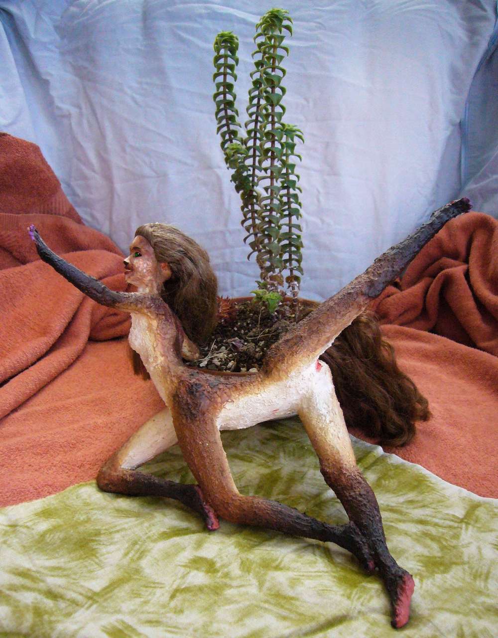
Sidera in Lake Fei: Hidden Succulence |
The big dip spoils linear oases too: no Nile can cross this central region to the sea. Creeks from the mountains mostly collect in the Tselang Sea in the deepest part of the rift, over 100 m below sea level.
The northern and southern hills flanking the sump do their bit too--blocking the rare storm from the north or south; that's why Tselang gets no rain.
On the other hand, the southern hills do wall off the desert, giving it a firm southern border. When the desert heats up in summer, the hills push up the monsoon winds rushing north and squeeze some rain from them. So the Kellonor Hills' south slopes have sparse woods and send down creeks through the savanna along Iba's south shore. The heights of the Rakshu Mountains even have pine forests and alpine meadows, two miles above the shimmering orange basin.
A few creeks of snowmelt wander from the Rakshus north into the desert; most feed Lake Fei, keeping it merely undrinkably brackish rather than caustic like the Tselang Sea. The mesas, hills and canyons around the lake do harbor life reminiscent of our cacti and Joshua trees; to right, a travelogue-dance starring Sidera, showing the huge succulants endemic to the hills north of the lake.
This will sound paradoxical, but Lake Fei had the bad luck to be a little too near the coast. Yes, there's some rain--but at a price. Millions of years ago, when only one of the current polar continents was polar, and Kakalea had less ice, sea levels were dozens of meters higher; back then, Fei was a bay, part of Idru Gulf. When the basin was eventually cut off by dropping seas, this salty legacy was enough to leave it undrinkable. Ancestry matters! Had the Idru Fault created the Fei basin farther inland, snowmelt from the Rakshus might well have created a fairly stable, brackish but drinkable lake.
Oh, well!
Tselang's history is different. It never was part of the sea; but when only one pole had a large icecap, the ocean was higher and the Iban outback got some rain; primeval Tselang may have been bigger than our Black Sea. As the polar caps grew and the rains died, Tselang shrank to a third of its former area and less than a tenth of its volume, concentrating from merely brackish to caustic.
The northern hills only corral the desert in the west, near the sea; north of the hills here is a wide steppe. Shortgrass, with no streams, just wells and waterholes, but grazable. Inland, though, the weak rains fail, and the hills are too low to hold the desert back; it spreads up to 1250 km north of the hills. The Tlai Range upwind is just too high, too good at its job of blocking all storms.
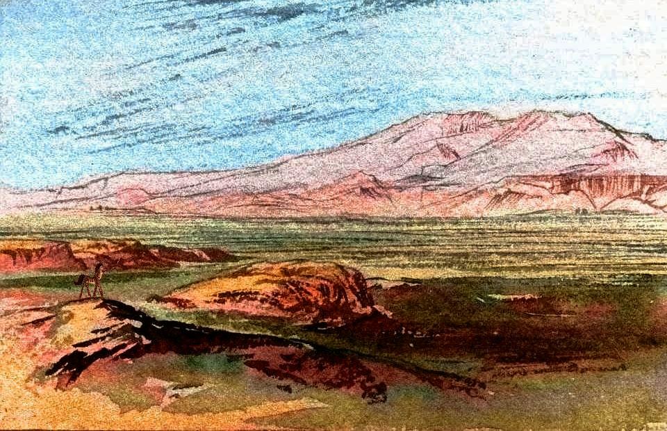
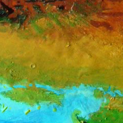
California or Morocco might well look like this too, if they were flat as a table. Well, Tsofe's not that flat; gentle, rolling swells the size of whole counties, with slopes almost imperceptible on the ground, creating drier strips and greener bottomlands. The orbital photo, shot near sunset, exaggerates these--but reddens them unrealistically, too. Not dunes or great rock domes, just low broad dry-grass ridges; and those pools of shadow hide green meadows and drinkable if shallow and seasonal creeks.
Let's sail up the west coast past Idru Gulf. North of its dry shores is the Fodiri Peninsula, another merely semiarid 'oasis' in the desert around Idru. Three hilly capes, called, imaginatively, South, Middle and North Cape, shelter two large bays, each with a small port at a creekmouth. Drinking water, but not enough for navigation. So the farms and herders in the hills are strictly subsistence, trading little; they might as well be 1000 km inland. Scrubby hills, a few trees along watercourses. Low cliffs, mesas. Greener than Baja California... but not much.
The north shore of Cape Fodiri is a semiarid plain, neither scenic nor remarkable. But inland, floating on the horizon, you can faintly see white teeth: the Roabei Mts, a cluster of snowcapped volcanoes above a confusing knot of lower pine-mantled ridges; by far the highest peaks in the west, and the source of all the streams you'll see along this coast (none large, but many perennial; and out here that's precious).
A day north along this low dry shore, past Tolda Bay, you see your first trees away from creeks since the Cape. Port Hochish, on the north shore, is a pleasant town, tree-shaded in spots, elsewhere by ramadas of woven reeds. Intricate basketry fills the market, as much art as practical craft.
The coast ahead is a narrow fog-fed strip of Southern Californian climate. It's the border of the third great Iban coast, Toresha.
The next day is all open woods and grasslands. Inland is the source of all that wicker and basketwork; two huge, brackish, marshy lagoons, the Hochish Lakes, lie inland, humidifying the air. Small but prosperous towns dot the shore. Climatically this stretch of coast is almost an ecological island. It doesn't always take mountains to create a California! As readers in Perth know well.
By the next day, it's clear that winter rains here are more reliable. Groves of low trees are merging into an open but continuous wood. Gardens and fields keep it open and sunny but it's clear that without agricultural meddling this coast would revert to mostly forest.
Next day we reach Port Tsofe, the economic heart of south Toresha; a true city at last. It straddles the mouth of the Tsofe River draining most of the prairies inland. An elegant, arching stone bridge spans the river, unifying commercial North Bank and residential South Bank (not random! On the north side, the sun glares off the river, spoiling the view much of the day. And South Bank tilts away from the sun--the Tsofe's lower valley is pretty flat--but what slope there is tends to provide cooling shade.)
The next day, north of town, the coastal strip is tall, dense forest. Very tall indeed--central Toresha is like California's redwood coast--rainy, but without snow or fierce storms: ideal for big trees. Kakalea's high gravity and thin air mean they top out at 70 meters (230') and average only 50 (165'). Still, it's impressive after weeks of savanna and scrubby low woods.
Note that these Big Trees aren't a single species like redwoods; a dozen different trees claim niches from dry to wet, rocky to silty. And most are broadleaved. The tutai bears pseudo-coconuts--a real hazard in a wind! The peroro has equally huge papayalike fruit, though they taste strongly resinous, more pine-nut than mango (you love them or hate them).
For days you pass low hills, trees sometimes topping the hills, modest cleared patches, fair-sized towns at each rivermouth exporting fruit fresh and dried, nuts by the ton, lumber of course; plus grain from the inland prairies and metal and gems from the mountains beyond.
Slowly the woods grow a little lower, darker, mossier, with more nuts and less giant fruit, as we pass the latitudes of Portland and Seattle and approach Vancouver...
Up a long sound, Kori Bay, sheltered by the cliffs of Cape Aluku, to Port Kori, the northern capital of Toresha. Music-inns--a world-class music/dance/theater school is here, so standards are high. Wood specialties fill the shops--musical instruments, all-wood clocks (one wood's so tough it makes perfectly adequate gears), graceful dance-figurines and erotic carvings... true, such figurines are ubiquitous on Kakalea, but often they're just enthusiastic crafts--souvenirs and conversation pieces.
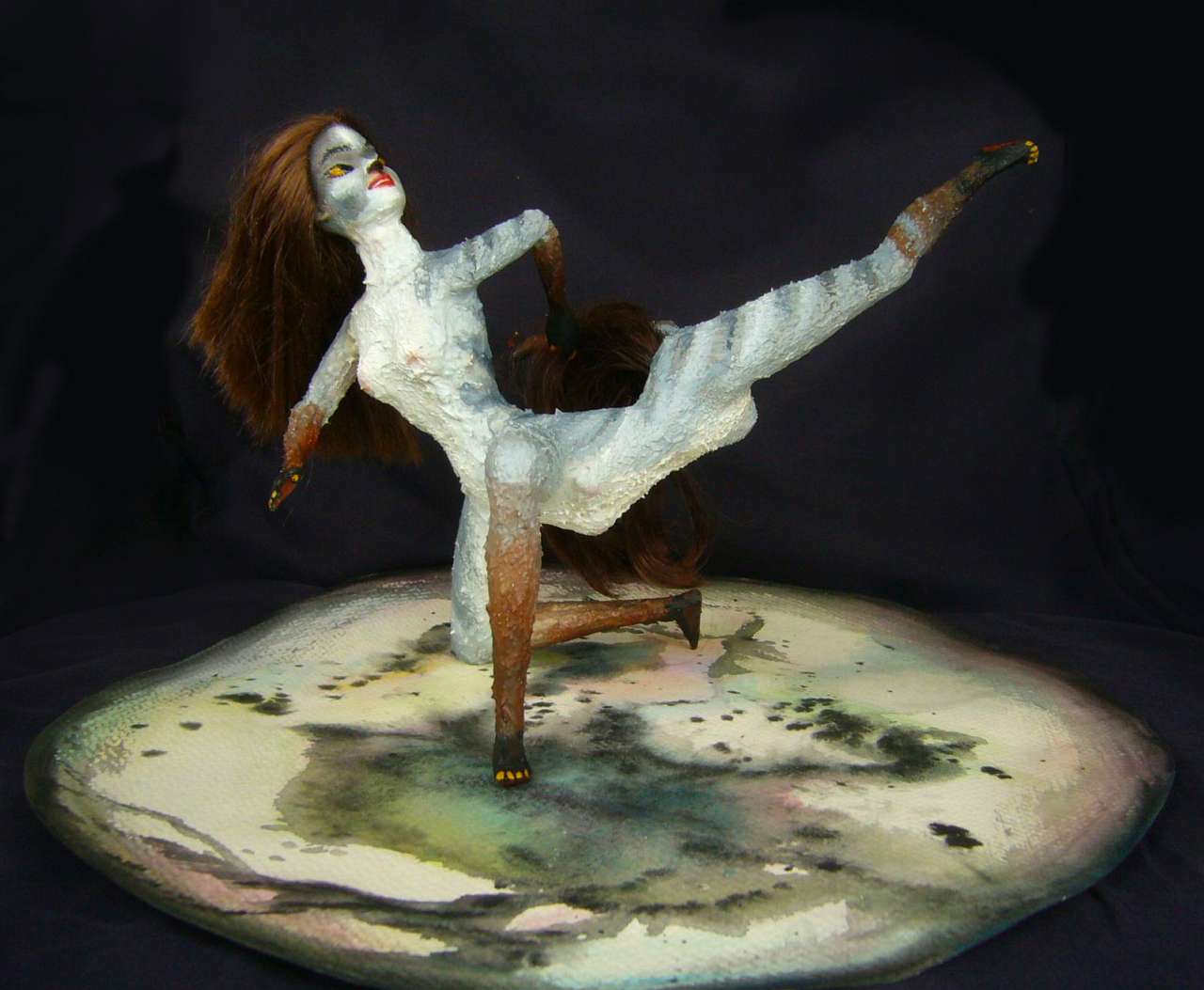
Toreshan work is not just finely crafted but art; (centaurian) Art Nouveau. Such figurines may come with a dais or even a diorama to stand on, but unlike many Terran figurines, they're never fixed to the base. To be considered a successful barabii, a figure must stand on its own in more than one pose/orientation; ideally it should be stable in many.
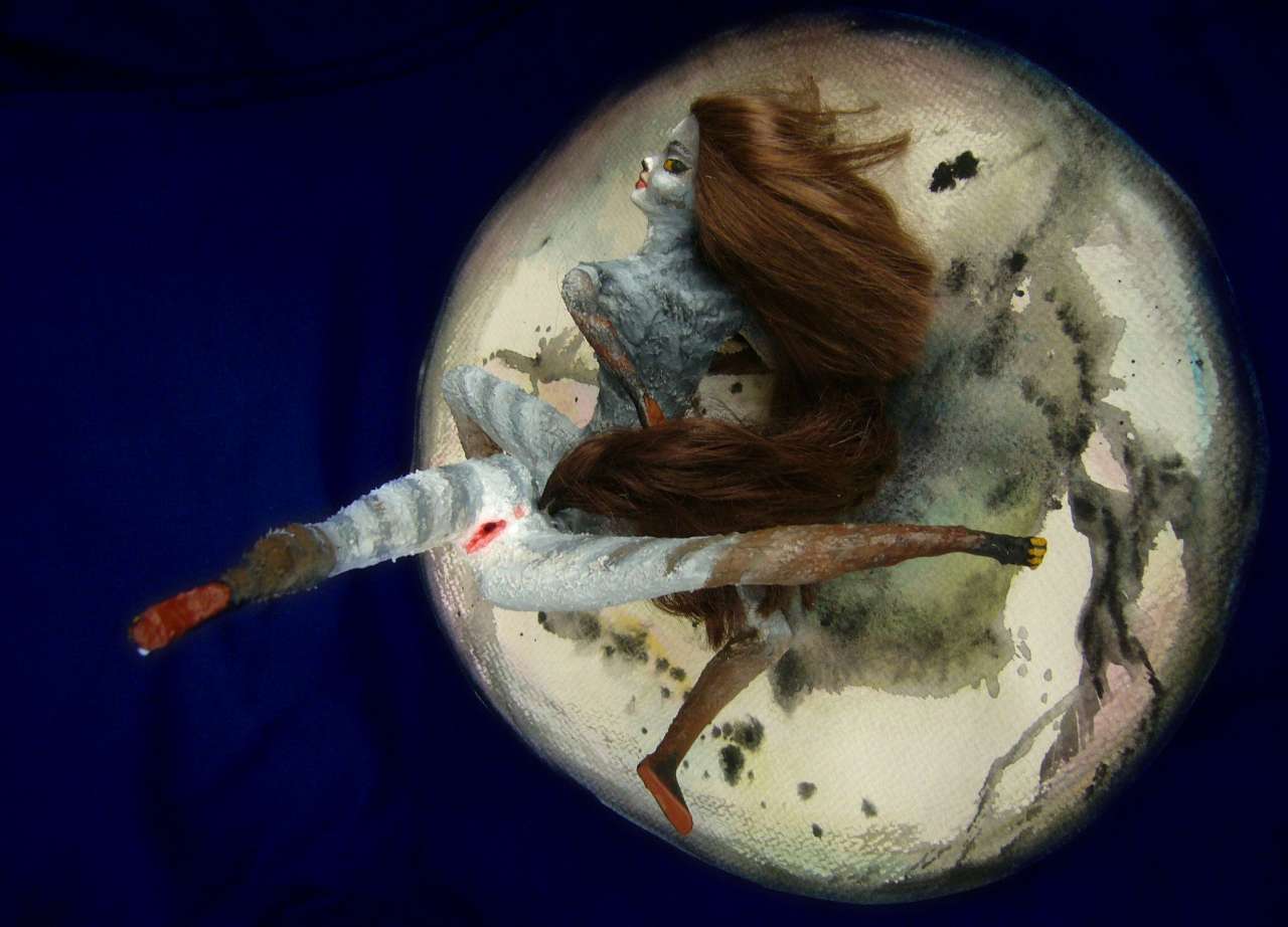
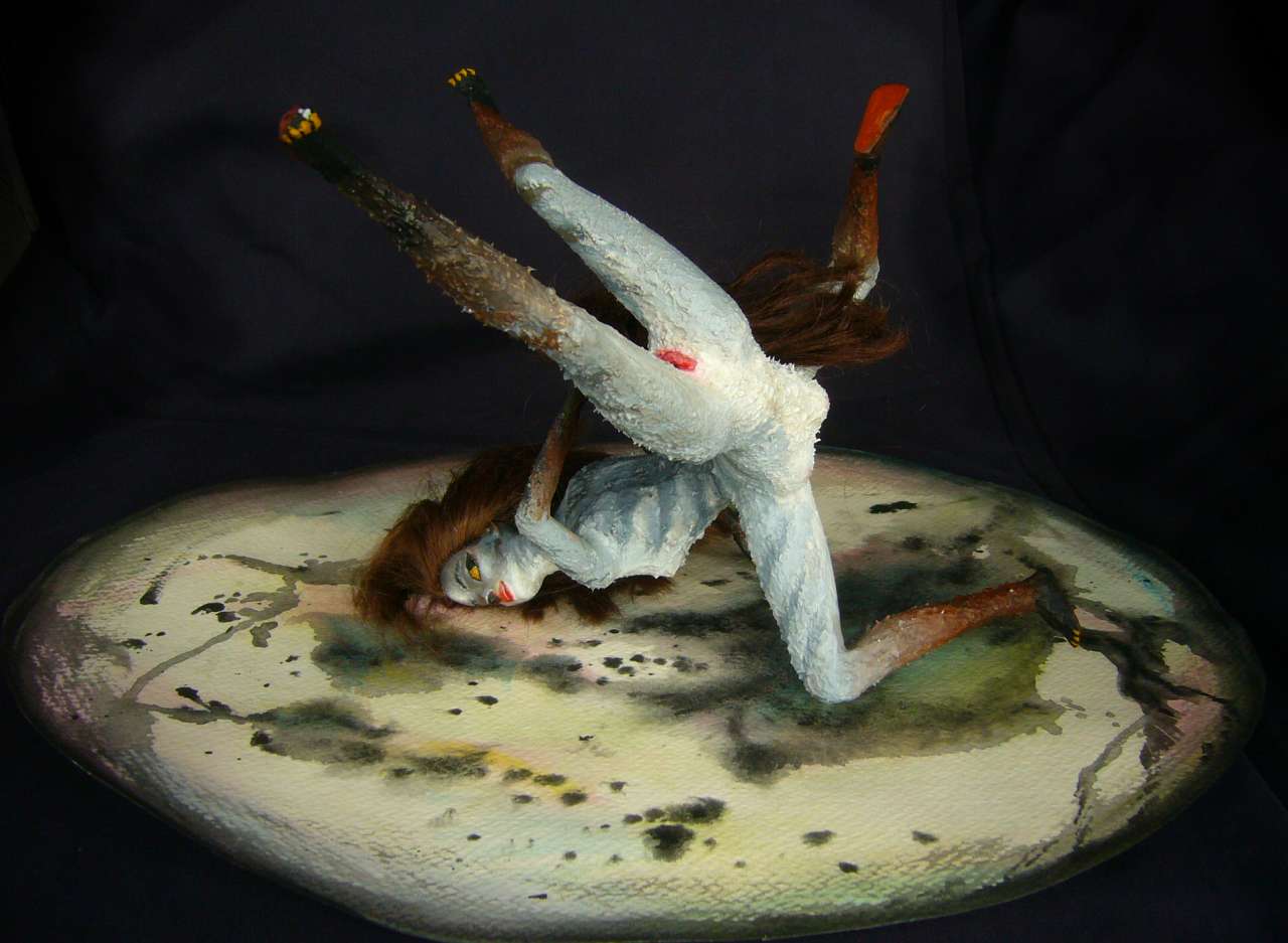
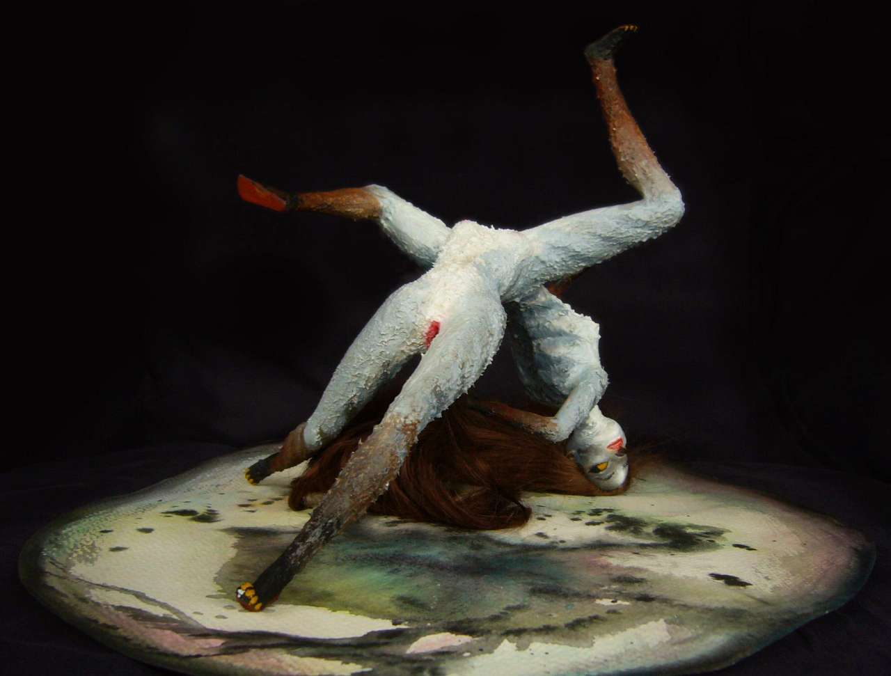
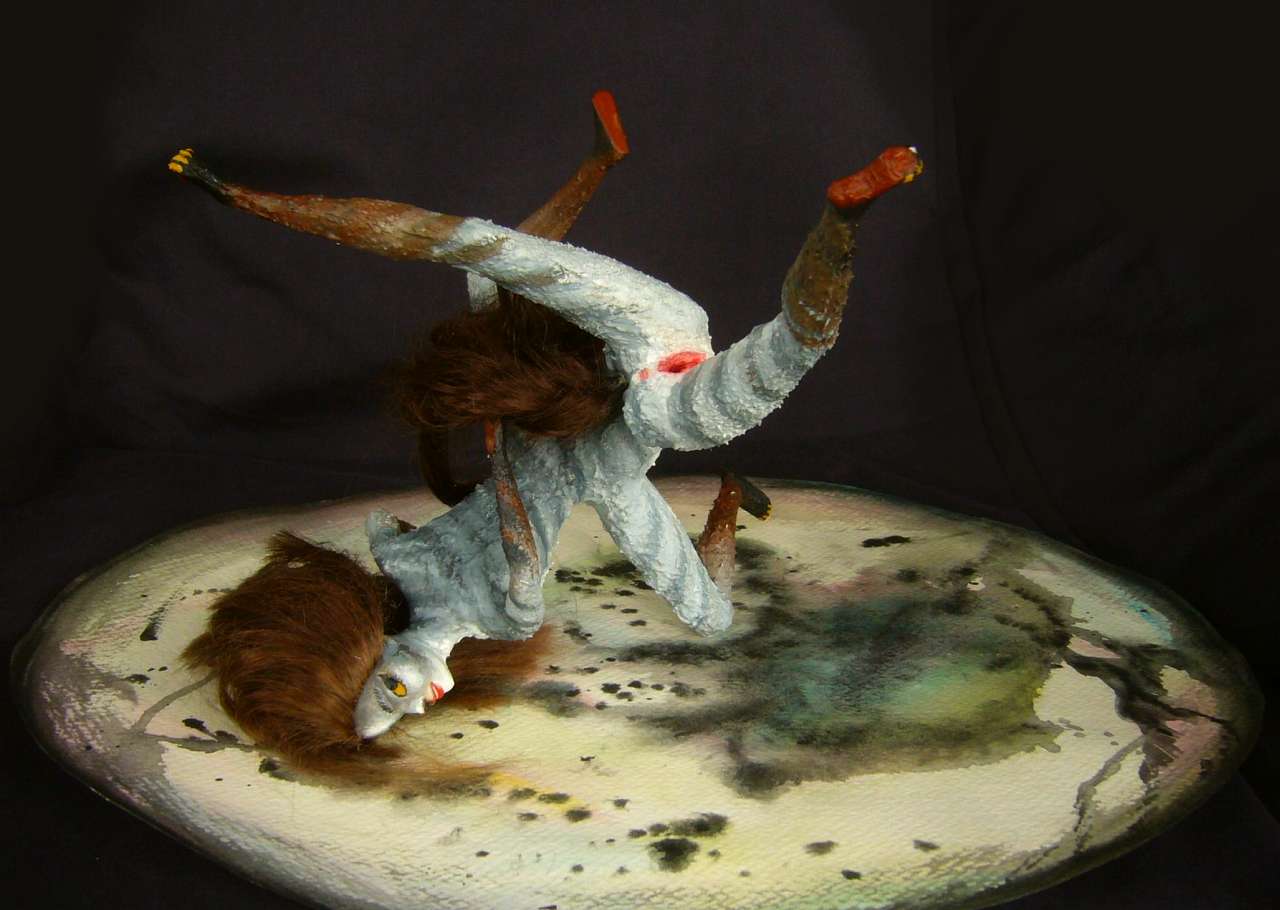
Here's a portrait of the popular dancer Spira, showing just seven of the thirteen stable orientations I found; in essence, thirteen pieces for the price of one...
|

|

|
| ||
|
|
|
Back out Kori Bay, round Aluku Head, north... for another week of endless forest. Conifers now, almost entirely. Bluer, colder, lower... but not much lower. This misty coast is plant heaven. A bit cold for you--even more so for the average Kakalean, built for hot savanna. The locals here run big and shaggy.
The last major harbor is Port Garra at 55° north (like Ketchikan or Prince Rupert), sheltered by Garra Hook. Beyond, the coast is exposed, low, windy; the trees shrink, thin, huddle in the wind. Rain every other day, even now in high summer.
You can't tell it for the first couple of days, but the land is narrowing. We're onto Cape Arei.
The third dawn after Garra, great blue shadows stretch across the red cloud-banners--crags hundreds of km to the east, barely on the horizon yet. But by noon, white teeth float over the rim of the world. The last of the Tlais, above the far shore of a quickly narrowing continent.
Trees are few and low; cold grasslands stretch miles. Bogs and bracken.
By evening, the coast recedes to the east; we're in Ngari Strait.
All the next day we tack east through the strait. A tedious passage; the winds here, and further north, blow westward not eastward as at lower latitudes. Right in our faces. Still, by sunset we're back at Port Arei where we began. Though it's improved considerably in the months since we left--still treeless and windy, but with green meadows now, rising to sculpted horns. Sheep and Icelandic ponies graze. Or so it seems until a pony raises her head and becomes a young Kakalean shepherd, so shaggy you didn't notice her hands plucking stems to weave into a lover's necklace.
Well, our illustration doesn't show that, of course; this is Kakalea, where everything ends up on stage! Fabric flowers, backdrop peaks. A real Areian girl would be a bit stockier and have curly tail- and head-hair, not straight. But our dancer, Lina, plays the role knowledgeably enough--she's a real northerner, though from the Morla Islands over 6000 km (4000 mi) to the east. If you've tried any of the northern tours, you've met her sister Lia, a well-known singer in Port Morla, with an even rougher coat and wild hair fitting the part better.
But Lina was insistent--she wanted equal time with her sister. For me, available always trumps authentic. At least on Kakalea.

But if you want authentic, remember the sheep aren't sheep, either. They're picking grasses with their forehands, stuffing and munching with their heads up, watching for sea-eagles. Yes, of course their shepherd-girl is supposed to whack eagles with her hawkstaff (well, they dive too fast to really hit--faster than a baseball--but a few good swings and they'll look elsewhere. At their speed, even a wing-tap could crack a bone). Kakalean sheeptaurs still keep their heads up. Not the brightest stars in the cold Northern sky, but even they know better than to trust a lovesick teen to stay focused on the job!
Even north of Ngari Strait, on the polar continent of Kita, the islands and shores of Cape Ngari have stony meadows (and small fishing villages) in sheltered valleys and fjords for hundreds of km. Centauroid moose feed in the bogs, and caribou, hare and pika graze grass and lichen in sheltered upland hollows.
Beyond the settled lands, dry valleys and barren but ice-free shores extend another 1000 km before the ice swallows all. Bear and fox hunt seal along the coasts. Inland, there's less large life...
... except that the locals all swear there's a sort of trunkless woolly mammoth (who needs a nose when you have two strong arms?) They show you a skeleton--that's one BIG centaur! Some 15-20 Kakalean feet tall--though since the living species inherited delicate little pointy feet from their Savage Barbie Forebears, and Kakaleans run shorter than humans on average (just 150 cm or 5 Terran feet), the Kakalean foot is barely 8" long--around 20 cm. That would make our giant just 3-4 meters tall, not 5-6. Way less massive than an elephant--the centaur frame means the back might be just 2m/7' high, and the weight a ton or two, not up to six as with elephants. Still, that's pretty big.
If it's real. But is it? Are these the relics of a real species gone extinct, or of a race turned rare and shy, or are they fakes, a Piltdown Barbie or Bigfoot Barbie carved to promote tourism?
A giant like that ought to be visible from miles off, but it's a big rough land, and next to no one (normal-sized, I mean) lives inland north of the strait. Villages stick to the coast where shipping's easier--not safe or regular, exactly, but better than hauling on sledges or paddling up freezing rivers. There really could be mammoth centaurs in there. But unless you're a masochist, I recommend letting that mystery be.
No mystery at all, on the other hand, that life extends right to the base of the Great Ice! Cape Ngari is much farther from the Pole than our Antarctic Peninsula--more like Iceland, or the Falkland Islands if the undersea ridges linking them to Antarctica were bared by low sea levels. Windy and cold, but the ice hasn't swallowed all. And never will; this is as cold as Kakalea gets. The Ngari Peninsula is a refuge for Kitan land species unable to swim or blow seeds across the straits.
When Kita drifts off the pole at last and starts to thaw, Ngari will reseed the new-bared land.
LISTS AND LINKS: More worlds? Planetocopia! - dreams of other worlds - ecology - climate change - evolution - natural disasters - terraforming - sculptures and 3D art -
World Dream Bank homepage - Art gallery - New stuff - Introductory sampler, best dreams, best art - On dreamwork - Books
Indexes: Subject - Author - Date - Names - Places - Art media/styles
Titles: A - B - C - D - E - F - G - H - IJ - KL - M - NO - PQ - R - Sa-Sk - Sl-Sz - T - UV - WXYZ
Email: wdreamb@yahoo.com - Catalog of art, books, CDs - Behind the Curtain: FAQs, bio, site map - Kindred sites