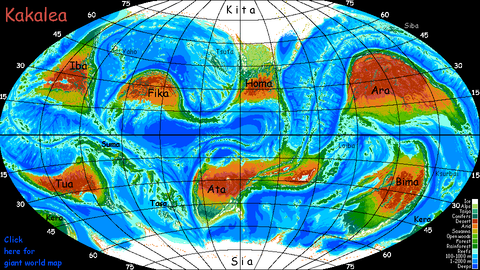
Kakalea:
TSUFA ISLES
under construction--overview only
by Chris Wayan, 2012-2015
for the Polynesians
Kakalea basics--map--geology--
creatures--
Building Kakalea
More worlds? Planetocopia!
Kakalea:
TSUFA ISLES
under construction--overview only
by Chris Wayan, 2012-2015
for the Polynesians
Kakalea basics--map--geology--
creatures--
Building Kakalea
More worlds? Planetocopia!
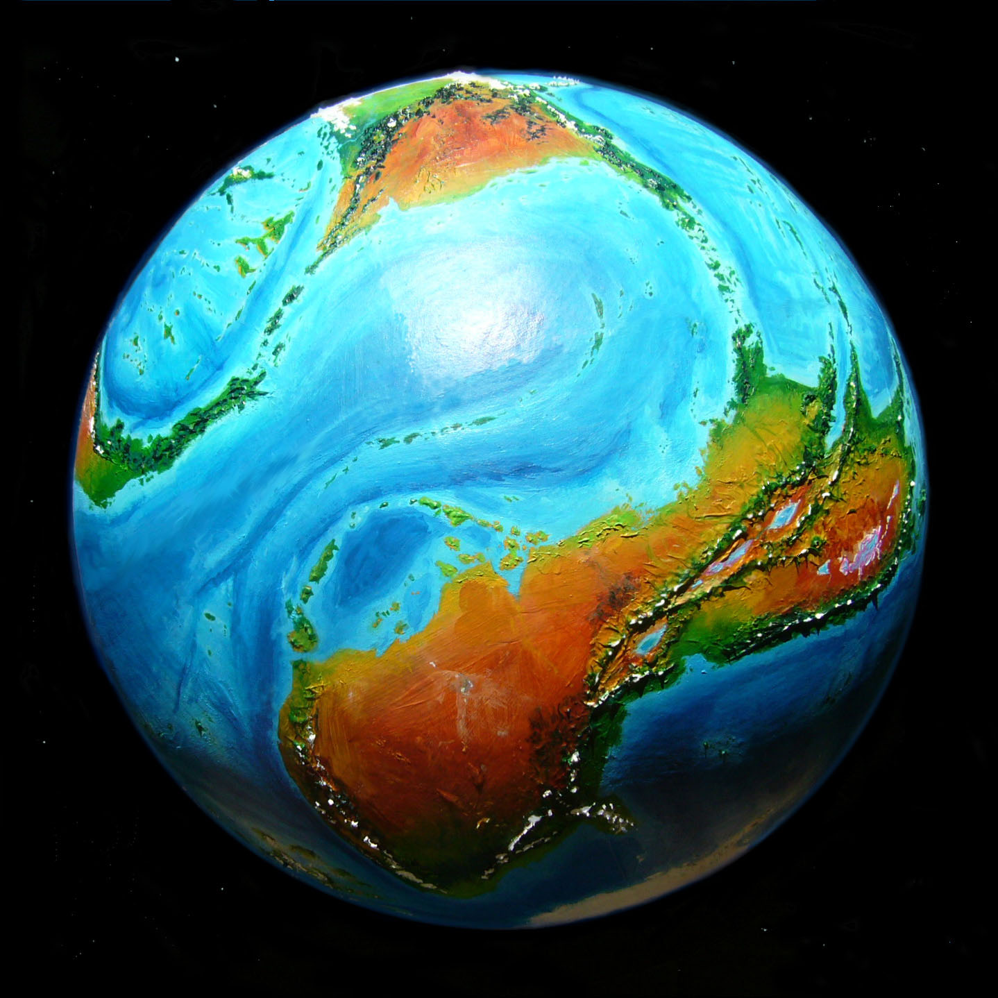
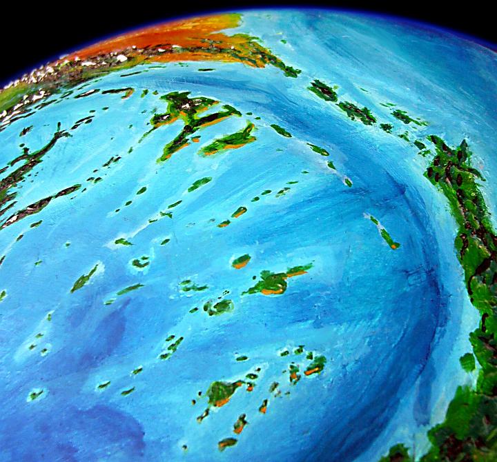
The Kifik Ocean is big, as big as our Indian Ocean--but only in area. Remember how shallow Kakalea's oceans are? Even modest seamounts can break the surface. Well, the Tsufa Archipelago isn't modest. The largest island in the Kifik, Tsufa proper, is comparable to Greenland stripped of its ice, and it really is green: one of the richest ecosystems on Kakalea.
And its five hundred sisters range from Arctic to Caribbean, wet to dry--and from mere mountaintops to one giant the size of Spain.
This huge Nordic island west of Homa is mountainous, cool, and evergreen-forested. The low-orbital photo above was shot looking east, with the polar cap to left and Homa on the horizon.
Two great mountain systems run southeast-northwest; the northeastern range, the Ispens, is larger, with glacier-mantled volcanoes and two icefields of many thousand square kilometers; but even the lesser Mbopa range along the southwest shore resembles our Cascades, with half a dozen icecapped cones rising like Fuji above the shallow sea.
Gale Bay, in the northwest, is unfortunate not only in latitude--distinctly colder--but in orientation; it's more open to arctic storms. Its shores are dark evergreen forest except near the very head of the bay, under the feet of the Mbopa Range. Here a New England-ish deciduous forest flourishes. The growing season is long enough for Kakaleans--at least the big, shaggy, cold-adapted local Kakaleans--to plant gardens if not farm extensively; some fruit and nut orchards do well too.
To the southeast, Maple Bay, as its name hints, is warmer--and richer in every sense. Slopes on the southwest face of the Ispens tilt toward the sun; farms and orchards, then forests and pastures, climb well past the great range's foothills.
The southwest shores below the Mbopa Range--the most southerly part of Tsufa--is a bit more exposed and windy than Maple Bay, but has a slightly longer growing season and is also densely populated.
The far southeast, out along Cape East and The Comb--is spotty. Windy in places, but southerly enough for every sheltered harbor or valley to be well settled.
You'll notice I mention temperature and wind, but not rainfall. No need. Tsufa, well out from any continental deserts and lying entirely in the temperate zone, is one of the rare Kakalean regions with a lot of land and not one desert. Yes, there's less rain between the mountain ranges. But 50-100 cm (20-40") a year, instead of two or three times that on some western slopes of the Mbopas, is still plenty for agriculture. Tsufa's a region where, for once, rain doesn't matter.
People up here run especially large and shaggy. I don't just mean they wear furs, though they do in blizzards; I mean the people themselves. Kakalean pelts are usually short--much of the land is hot after all--but in the Morlas, Ksefins and northern Tsufa, coats are long and shaggy year-round.
Here--on the left is Lia, a Morlan cabaret singer. She's no horsebellied Greek centaur--her lower torso is more human or antelope than horse. But her coat's not antelopian--she's as shaggy as an arctic wolf. On the right is a typically short-pelted southerner, Shya, a dancer in a troupe whose floating theater circles the mostly hot continent of Ara. Shya is willowy, yes--dancers of any species often are--but her much shorter coat exaggerates that ballerina look.
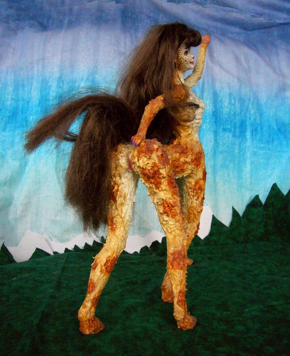
Lia singing Morla's Fish Rule |
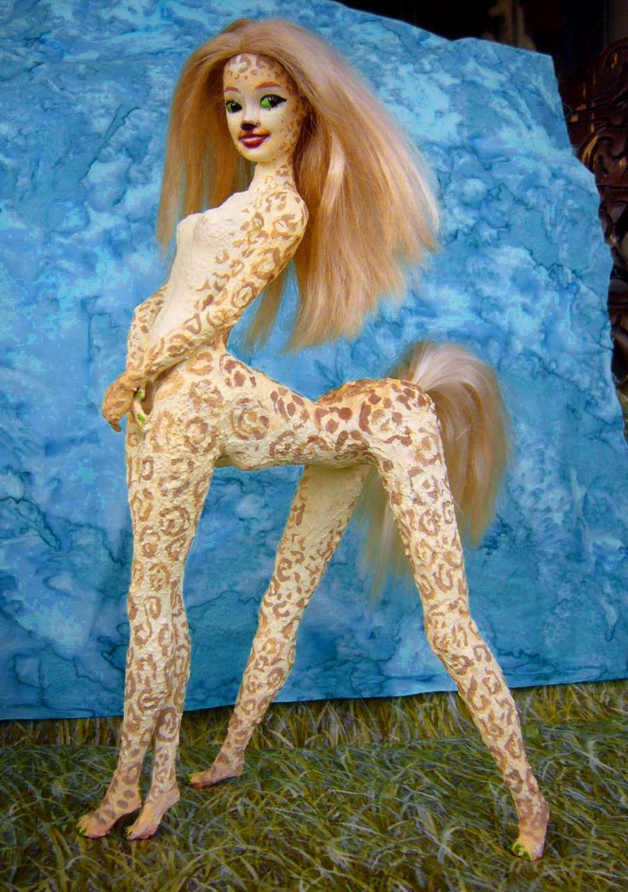
Shya backstage during Summer Heat |
Their nudity is normal, not a stage gimmick to attract audiences. Even short-furred Kakaleans only wear clothes in rain or severe cold--basically, hooded cloaks and/or horseblankets. Even those make them feel confined; fitted clothing's unheard of. Unnatural. Probably unhealthy.
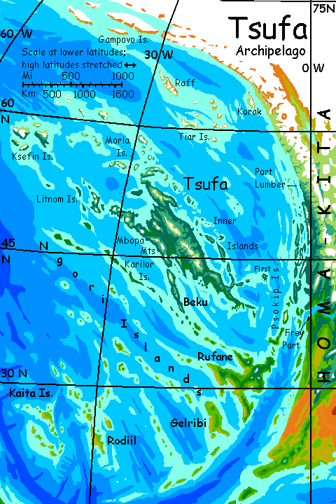
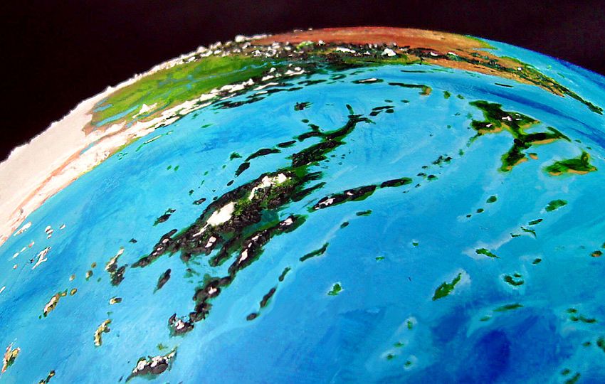
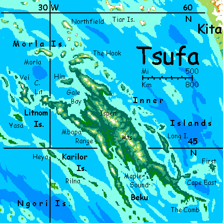
Around Tsufa in every direction is a halo of lesser islands. Lesser as in less than 1000 km long! But not much less...
Due south is Beku, 800 km long (500 mi), though as lean as Cuba or Java. Beku's clearly part of the Tsufa Rise--an extension of the westmost ridge of the mainland. To the southwest, a parallel ridge gives rise to the Karilor Chain, five narrow, mountainous islands up to 250 km long (150 mi)--miniature Bekus.
To the north, the Tsufa Rise isn't enough to create a continuous land, but a scatter of craggy islands sprawls between Tsufa and the polar cap. The northern third are the largest--Gampovo is 500 km long (300 mi) and two more are 3-400; but they're so near the polar cap they've iced over in sympathy. The central islands, like the Tiars and Morlas, vary--mountainous isles (many volcanic) are ice-mantled above bare windy shores, with at most grass and moss in sheltered hollows; yet lower islands here may be ice-free, some with meadows and even a few low woods on the lee side (south and west).
The tight Ksefin Group is the richest of these northern archipelagoes; as arctic as the Morlas (57-60° north) but much further from the icecap, whose coast recedes to the northwest. And this rugged knot half the size of Iceland luckily has ridges running right across the winds; the sheltered shores of central Ksefin Sound are forested, more like southern Alaska than Kerguelen or other windblasted isles off Antarctica. The south shores are cool and rainy, but more London or Seattle than Alaska.
Just off Tsufa's western shore are the Litnom Islands, resembling Ksefin: dark forests below pale meadows and blinding icefields.
Really, all these lands are mild for their latitude; off our Antarctica, they'd be icy. But size isn't everything: this Arctic cap is big, but not as isolated as Antarctica. The rugged continents of Iba and Homa keep polar winds from circling unimpeded, and the Kifik Ocean has a north-running warm current quite like our Gulf Stream--well, by this point the Iban Stream has cooled and bent to a tepid current east, but it still keeps the isles of northern Tsufa and even mainland Kita-Homa's coast relatively ice-free--not quite Earth's mild Arctic, but not Antarctica either.
The names here hint at the land's history. First of all, many are still translatable--they haven't worn down over millennia into incomprehensibility like most continental names. A lot are simple descriptions. This hints at a more recent settlement than one might expect. It may be that the archipelago was long known but little used. Why? Well, Kakalean centauroids don't like the cold. They evolved on dry hot savanna more recently than humans, and didn't go through an Ice Age. Worse, they hate to be encumbered by more than a strap or two--clothing makes them twitchy. So bigger, shaggier sorts (plus calm souls more tolerant of winter cloaks) became self-selected pioneers. And this took time.
One name is a flashing historical signal: the little isle of First, in the far southeast. No mystery who settled Tsufa, then! It had to be easterners from Homa (well, settlers from the Psokip Islands just off Homa's west coast). Not that this is any surprise--the ancient Taiwanese settled much of the Pacific, becoming the Polynesians, because offshore mariners' skills may not all transfer to deep water, but they're better than extensive experience in dryfarming or desert prospecting... But it's a nice linguistic confirmation that these big shaggy Tsufans evolved from gracile, rangy, normal Kakaleans, through... not Darwinian selection or random genetic drift either, exactly, but successive waves of migration, voluntary filtering, and more migration.
A subspecies created in a mere thousand years or so!
All of the eastern Kifik is island-rich; this is a basin under pressure. None of the southern islands rivals Tsufa, but they're still very big. Two very different pressures pushed up these arcs and ridges:
We'll start just off the west coast of Homa and sail south along the fault line. Here in the north it's not yet a trench, but a strike-slip fault like the one that knocks down San Francisco every century or two.
The Psokip Chain shelters this coast for 2500 km (1500 mi)--it's like Alaska's Inland Passage and then some. Half a dozen of these narrow islands are over 320 km long (200 mi). Misty north-south ridges, the highest with glaciers. The northernmost Psokips are treeless, but most nourish cedary boreal forests, very tall in the south.
The Psokips lead south to the largest island in the southern Kifik, Rufane. Three great underwater ridges intersect to create this Spain-sized tangle--the trench's counter-rise and two compression ridges running in from the northwest (the northern one leads up to Beku and Tsufa beyond; whoever paddles out along the Psokips to settle Rufane won't stop there!)
Much warmer and drier than the northern isles, Rufane has forested heights but Mediterranean lowlands. In places it's quite arid--we're downwind from Homa's southern desert. A few peaks are high enough to bear snow even in summer, but that's the last white stuff we'll see...
Gelribi, southwest of Rufane, is lower and thus even drier, with some true desert along the shores. The inland hills are Mediterranean, though: grassy but dotted with 'oak' and with woods along streams and on the heights. Our closest parallel might be Sicily or Sardinia.
Northwest of Gelribi is the longest compression-ridge; the Ngori Islands run some 2800 km (1700 mi), as far north as Tsufa and as far west as the Ksefin Group.
Five more chains, shorter but many with larger islands, parallel the Ngoris; each is a few hundred km farther southwest toward Fika, though the last is still 800 km offshore (500 mi). The Rodiil and Kaita chains are each nearly as big in area as Gelribi, and similar in climate--a bit more rain, as their storms sweep across 2000 extra km of sea; they're out of Homa's rainshadow. Twin Corsicas to Gelribi's drier Sicily?

The central Kifik has some fair-sized islands--the Linders, notably--but they're cold and sparsely populated; they're briefly covered in the tour circumnavigating the polar continent Kita.
The western Kifik also has several sparsely populated chains--the Sondrins, Chornas, Kraliches--but is dominated by the Yaho Islands, a chain like a temperate Hawai'i but much bigger. Remember Kakalea's shallow seas! Hawai'i rises from waters over 6 km deep--20,000'. Yaho's shield volcanoes are quite similar, but they barely have their ankles wet; 80% of their immense mass (and height) is above water, giving them ten or twenty times the area of Hawai'i. But that's another tour...
LISTS AND LINKS: More worlds? Planetocopia! - dreams of other worlds - ecology - climate change - evolution - natural disasters - terraforming - sculptures and 3D art -
World Dream Bank homepage - Art gallery - New stuff - Introductory sampler, best dreams, best art - On dreamwork - Books
Indexes: Subject - Author - Date - Names - Places - Art media/styles
Titles: A - B - C - D - E - F - G - H - IJ - KL - M - NO - PQ - R - Sa-Sk - Sl-Sz - T - UV - WXYZ
Email: wdreamb@yahoo.com - Catalog of art, books, CDs - Behind the Curtain: FAQs, bio, site map - Kindred sites