Kakalea:
YAHO
under construction--outline only!
by Chris Wayan, 2012-2015
for Native Hawai'ians
Kakalea basics--map--geology--
creatures--
Building Kakalea
More worlds? Planetocopia!
Kakalea:
YAHO
under construction--outline only!
by Chris Wayan, 2012-2015
for Native Hawai'ians
Kakalea basics--map--geology--
creatures--
Building Kakalea
More worlds? Planetocopia!
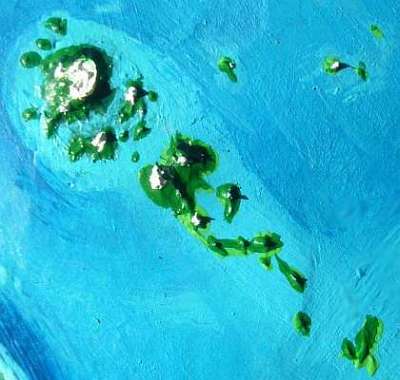
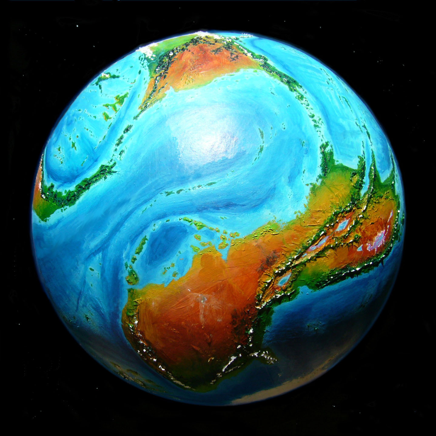
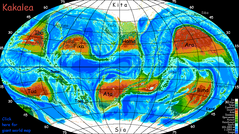
The highest peak on Kakalea is Mt Yai, a shield volcano rising from the western Kifik Sea; it's 9 km above sea level (29,500'), topping Mt Everest. From its undersea base, 2 km down, it's 11 km or 36,000' tall, a near-perfect twin to Earth's tallest mountain, Hawai'i. In Kakalea's higher gravity this may seem surprising. The reason is local: the sea floor above this hotspot is moving quite slowly, so that lava flows build up around the same few vents; Yai is more like a Martian volcano than Hawai'i. A chain of islands and reefs does mark older vents, but it's much shorter than Hawaii's.
Yai resembles Olympus not Hawai'i in another way: Yai's caldera isn't just stratospheric, it's fully 100 km wide. Spectacular inner cliffs and scarps drop several km. It's hard to be sure how high these cliffs really are, for the caldera is ice-choked at least 3 kilometers deep, forming (along with the glaciers on the outer slopes) the largest icefield in the world unconnected to the polar caps. A fourth of the island is ice-covered--quite a bit more than, say, Iceland.
So is the rest of Yai like Iceland too? Hardly. Yai's neither Hawai'i nor Iceland. The Yaho Chain is in the temperate zone; sheer altitude created this icefield, not a subpolar climate. The coasts and lower slopes of the great mountain up to 1500 m (5000') are unbroken forest. From 1500-2000 m (up to 6600') is a subalpine belt 10-20 km wide, then a ring of alpine meadows equally wide, as high as 2500 m (over 8000'). Above this is only bare rock and snow, then permanent ice. There's a lot of 'above': 6500 vertical meters of it (21,500') at a couple of points on the caldera rim.
But remember, these zones are concentric. Most of the island is lowland.
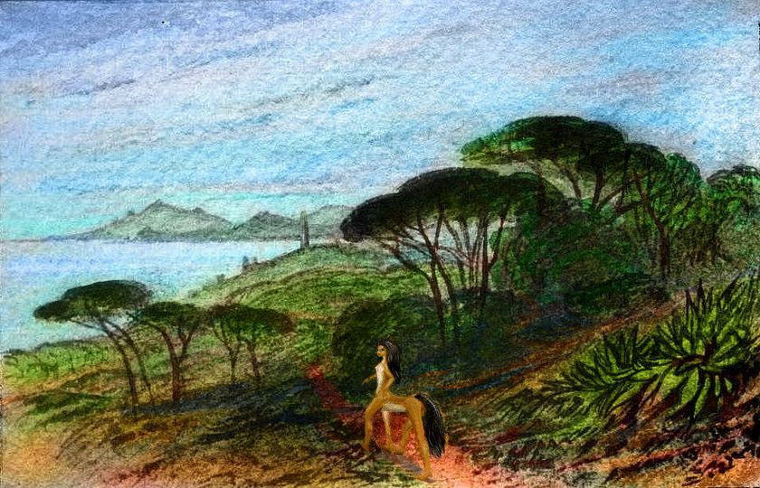
Over half of Yai, and nearly 80% of the chain as a whole, is forest. Rich volcanic soil, moderate rains, a temperate maritime climate. Whether Kakaleans are Terran-style farmers clearing and tilling fields, or orchard-growing silviculturalists, the lowlands are as stable and productive as the fields of France, China, America.
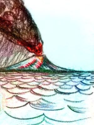
But Yayans (as they call themselves) always keep an eye on the horizon. Most eruptions in the Yaho chain now emerge from lesser vents, lower down; but the few that vent from above the snowline on Mt Yai (and several more high peaks) can be deadly. Avalanches, steam explosions and giant mudflows are just some of the unpleasant possibilities. Eruptions themselves are never violent on the scale of Krakatao, Tambora or Mt. Saint Helens; for the magma here, like Hawaii's, is runny; the pressure never builds up to wreak that sort of catastrophe.
But lava plus ice is always trouble.
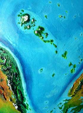
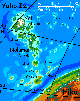
Yai is the largest island in the Yaho chain only if you're a geologist measuring volume. All those fresh lava flows ('fresh' as in 'under five million years old') do add up. But Nolumai, in the middle of the chain, is actually a hair larger by area. No surprise; at least five major and many minor shield volcanoes are welded together to form Nolumai. But all are currently dormant and most are dead; the hot spot's moved on. Glaciers, in this temperate climate, have gnawed quickly at the summits; peaks once Himalayan or Andean have eroded down to merely Alpine height. Or Hawaiian, in the above-sea-level sense.
If we're measuring viable land, Nolumai's area is quite a bigger than Yai's, since the newer island's caldera and shoulder-icefields thrust right out of the biosphere; in contrast, nearly all of Nolumai is fertile forest or meadow. Very little is ice today.
Erosion continues, but it's slow; temperate rains aren't that torrential, and the greenery anchors the soil.
For Kakaleans, Nolumai has other advantages. It's a bit further south, and away from the ice; warmer and with less extreme weather. Erosion has left its shore full of harbors, where long stretches of Yai's coast are still brutally simple.
The result? Nolumai is central in every sense--geographic, size, population, wealth, culture. Southeast Yai, even together with its halo of lesser islands, make only a strong second.
Lesser, indeed! I count at least ten and possibly seventeen other islands bigger than Maui; several are bigger than Puerto Rico; one, Cheku, is bigger than Taiwan! Most of these are further south than Yai and Nolumai. Lower latitude and lower altitude (fewer active vents here; these are eroded isles with much broader coastal flats) combine to make the southern two-thirds of the chain subtropical. They feel Mediterranean--the dry west coast of Fika lies not far upwind. Ecologically and to some extent culturally, they're unlike the north; more akin to the nearby Tressat Coast on western Fika. Why not? It's closer, and the same crops flourish.
Hawai'i's older islands are mere seamounts now; so why are these islands still so large? Yes, the Pacific is very deep and can swallow whole islands without a burp, while Kakalea's seas are shallow, so that as isles erode they simply spread out; but that's not the only factor. The sea level is stabler too. During our Ice Age, dozens of large Hawai'ian Islands, low but broad, stretched across the North Pacific. But the sea rose over a hundred meters in the last 20,000 years as the icecaps shrank, drowning islands worldwide. If Kakalea's oceans look unnaturally island-rich, that's false; the truth is Terran seas are island-poor. Temporarily...
A couple of other factors have protected the Lesser Yahos. They're warmer than Yai and Nolumai; their peaks are low enough by now to lack ice entirely. Rain is their only real eroder left; and here the rains are milder than on the younger isles to the north (or in our North Pacific).
Coastal erosion is modest too. This arm of the Kifik Ocean, between Iba and Fika, has a narrower "fetch", with lower swells than Hawaii's famously large waves. So old Hawaiian islands have ended up as atolls or seamounts; but the Lesser Yahos will be around for a long, long time--until the trench off Fika to the southeast swallows them. Even for Loko and Cheku, the nearest, that'll be many millions of years; plate-drift here is leisurely.
Actually, the isles nearest the trench are growing, not shrinking. Note that Cheku has snowcapped volcanoes--pipsqueaks next to Mt Yai, but reawakened enough to build themselves up again. And the sea floor here has lifted several hundred meters, too, forming a modest island chain paralleling the trench--Loko, Kamui, and lesser Lessers. Such ridges on the subducting side of an active trench are equally common on Earth and Kakalea; they're just modest compared to the Andean ranges on the continental side, so our much deeper seas hide them all. But not on Kakalea! The Kifik Ocean has even larger examples, like Rufane and Gelribi, south of Tsufa. Indeed that group is linked to the Lesser Yahos; between them, all along the arcuate trench north of Fika, more island-chains rise--Kaita, Tapai and Limyara.
One of Kakalea's largest telescopes, just over half a meter (20") stands high on the flank of a dormant volcano on Cheku. Mt Yai, with its incomparable height, offers even thinner air and better seeing, but has two fatal flaws:
The observatory is a matter of pride in the islands and has stimulated interest in science; the main university on Nolumai is quite prestigious. Fine arts in the region are often astronomy-tinged. Here's Aifelle in a strange astro-ballet, playing a mad astronomer transported in dance-vision through the telescope to nearby Skea, a small, dry, rather Martian world, with great shield volcanoes first seen here at Cheku. Aifelle the Mad Astronomer confuses them with Yaho's own shields, on one of which the observatory stands.
Set a volcano to catch a volcano...
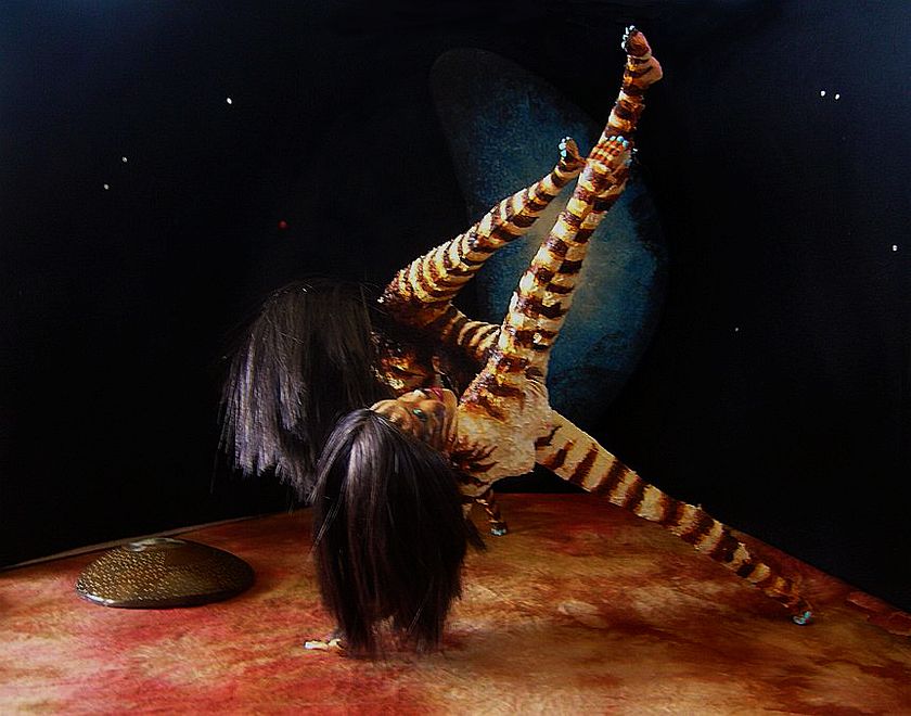
Sorry it's so motion-blurred; it was dark and she got pretty wild. She had reason, but to explain that I have to pose a question: Which world is our Mad Astronomer dancing on at the moment?
Motion was the language of the piece. Place was communicated entirely through dynamism. in the opening and closing Kakalean scenes, Aifelle moved gracefully but leapt and fell with a swift Kakalean gravity; when on Mars-sized Skea, Aifelle bounded lightly, seemed to float mid-air, landing gently, even skidding a little.
A subtler thing than Michael Jackson's Moonwalk; Aifelle's Marswalk.
LISTS AND LINKS: More worlds? Planetocopia! - dreams of other worlds - ecology - climate change - evolution - natural disasters - terraforming - sculptures and 3D art -
World Dream Bank homepage - Art gallery - New stuff - Introductory sampler, best dreams, best art - On dreamwork - Books
Indexes: Subject - Author - Date - Names - Places - Art media/styles
Titles: A - B - C - D - E - F - G - H - IJ - KL - M - NO - PQ - R - Sa-Sk - Sl-Sz - T - UV - WXYZ
Email: wdreamb@yahoo.com - Catalog of art, books, CDs - Behind the Curtain: FAQs, bio, site map - Kindred sites