

Lannach and Dawrnach
by Chris Wayan, 2006
dedicated to Poul Anderson for his remarkable world-building
Lyr (home) - map - creatures - cultures - evolution - climate - geology - gazetteer - nomenclature - definitions - building Lyr - more worlds? Planetocopia!
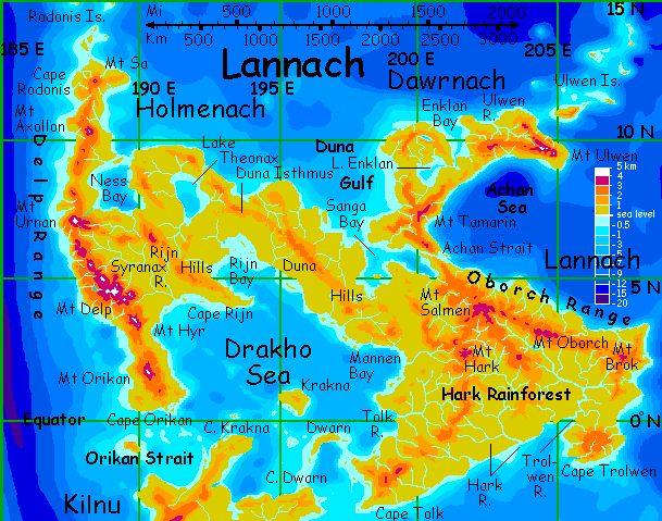
LANNACH
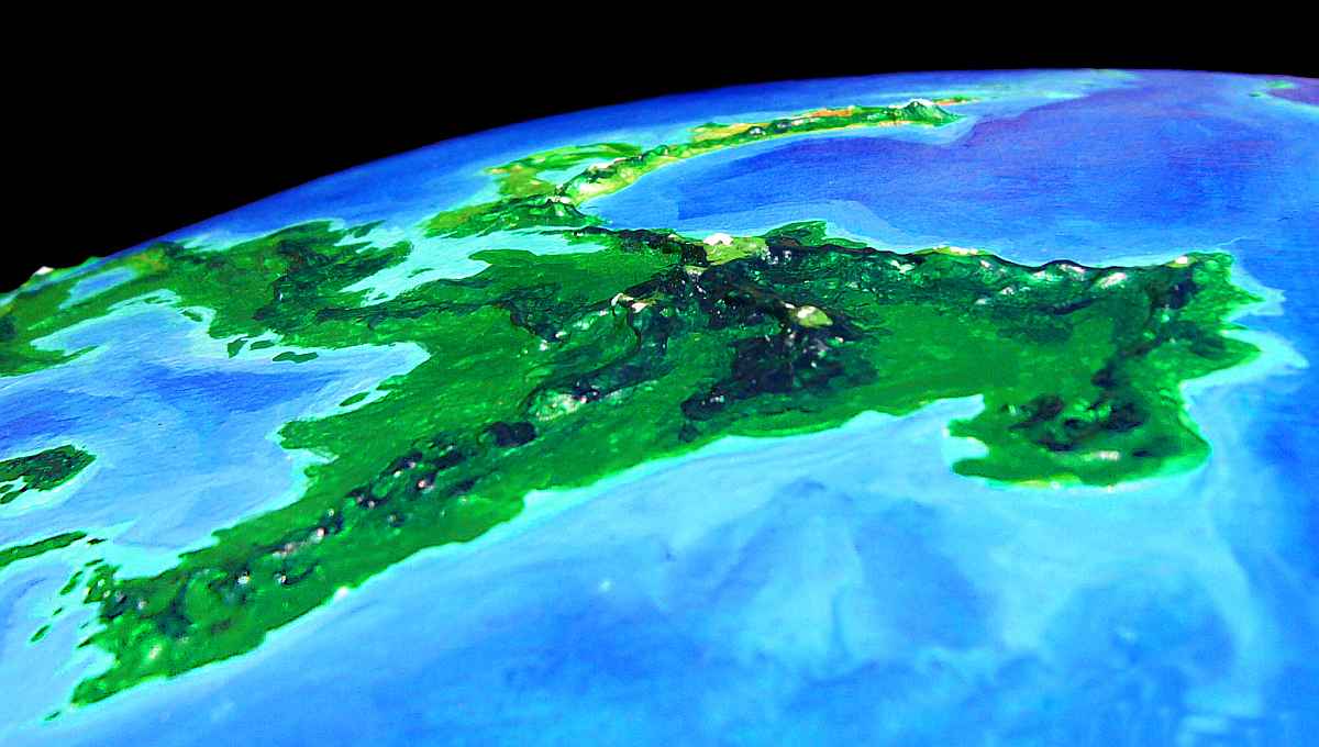
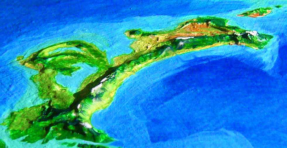
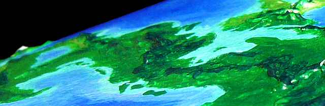
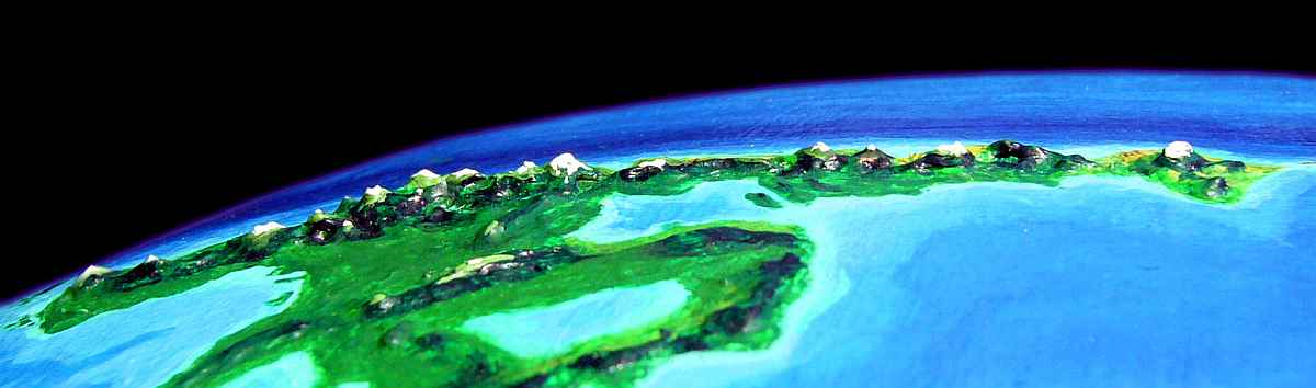
Lannach, the heart of the Diomedes group, is the one of largest continents on Lyr--nearly 8 M sq km (3.1 M sq mi, around the size of Brazil). The east is all equatorial rainforest, though the rugged western subcontinent of Holmenach is a lot more diverse.
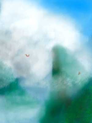
We'll start in the far south and assume you flew in from Kilnu (bottom edge of map). You land on Cape Tolk, a rugged peninsula with peaks rising to 3 km (10,000'). All day you thread your way between misty peaks mantled in dense cloudforest up to the summits. Toward sunset, on the far side of this coastal range, the land settles down; a line of hills continues straight ahead, but most of this inland forest is flat as a plate to the horizon--and far beyond, for 1500 km.
The next day, flying east, you reach the boundary of mainland Lannach around noon: a low divide beyond which the slow streams wind northwest into the Tolk River and northeast into the Hark. We can't tour it all; let's ignore the thousand miles of Amazonian jungle of the Tolk Basin and around Mannen Bay, and flap on into the Hark Basin covering all southern Lannach--and the largest rainforest on Lyr.
Here in the middle of the lushest land on the planet, amid an unbelievable profusion of species, I have a confession to make.
I find it hard to write much about Lannach's rainforest because it's impoverished in what interests me most--intelligent species. Huge and fertile, but isolated, contiguous, and monotonous, eastern Lannach has fewer peoples than the Oronesian islet of Eyath, a tenth its size. Well, my comparison's unfair--Eyath is a Lyran cultural crossroads, an informal capital with many quasi-diplomats and travelers who loved it and settled down--it had no native intelligent species at all, and Lannach does! Still, many other small islands with varied climates outdo all Lannach, too.
It may sound like I'm equating Lannach with Amazonia or Congo--lush but thinly inhabited, actually less friendly to people than savanna or open woods. That's not quite true--koreens, unlike humans, aren't trapped on a dark protein-poor forest floor. Tauraffes are, in a way--but huge-eyed herbivorous people twenty feet tall don't see "dark protein-poor forest floor" the way a human does! They evolved here, and thrive, just as elephants or gorillas would.
Mind you, I can call these forests lonely only from a Lyran viewpoint. Koreens and tauraffes, plus occasional lebbirds and icari and sphinxes on the coasts together comprise a pool of intelligent species richer than any of Earth's continents (though I'm not so sure about seas). But for Lyr, it is thin.

The most diverse intelligent life is found in Lyr's drybelts. For a dry land on Lyr isn't all that dry--mountains and east coasts still snag storms and water forests, but on the lee sides, savannas and deserts add to the diversity. Equatorial Lannach has the largest biomass AND total number of species of any land on Lyr... but is it, in a subtler way, deprived? Are intelligent species indicator species, indicators of a subtler kind of diversity? Intelligence, by definition, deals in change, borders, diversity, novelty. Maybe the richest ecologies aren't the friendliest for consciousness. Just as music can grow too complex and blur into a wall of sound, can life flourish so much it forms a wall of green--a new kind of monotony?
Or maybe your fearless jungle guide is tone-deaf to Amazonian delights today. Could just be my allergies making me grumpy. Victimized by vegetation, so I take literary revenge! Sleazy, eh?
Three days of jungle plains! The treetops are bright with flowers and life, but a bit risky for clumsy fliers like you to explore up close. Break a wing and you're stranded 70 meters up a tree--or you fall. "Look but don't touch" gets frustrating after days... The only safe landings are the pads in koreen villages--where you're welcomed, but spend noisy, bad-sleep nights. It's hard to tune out the shrieks and scurryings and winged monkeys grooming you. You just wish they'd ask.
You reach the mouth of the Trolwen River. Cape Trolwen to the east, across the bay, is a blunt peninsula 550 km (350 mi) across whose heart is a tropical plateau 1500-2400 m high (5-8000')--an ecological island above the steamy Hark Basin on the mainland. But let's skip the Cape--it resembles the Oborch Mts, which we're headed straight for. Just one more day and the monotony ends...
THE DRISS CHAIN
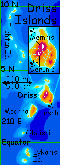
On the far side, Cape Brok is the jumping-off point for the Driss Islands. I'm tempted to take a side trip; Driss itself is pretty spectacular, like a hyper-Hawaii 500 km (300 mi) long, with four volcanic cones rising 3-4 km from the sea (highest: Mt Memnis, 4500 m/14,800'). And these aren't gentle shield volcanoes: the whole Driss chain rises sharply from deep water. Were the range on land, it'd be Lyr's greatest spectacle, with steep scarps, almost cliffs, up to 2.5 km (8000') high. On a world with somewhat higher gravity than Earth, scarps like these are geologically shocking. The formation appears to be a tilted fault-block at the rim of the Diomedes Plate. But why it ends so violently is a puzzle; and the crisp, repetitious scalloped structure is like no Terran plate boundary. Whatever's causing it isn't unique to Driss or even the Diomedes Cluster; it's echoed to the north in the Ulwen Islands, and on the far side of the planet in the Dwyr chain.
We could follow the Driss chain north, through the Flichtan Islands. None are over 80 km long (50 mi), but they're fertile and lovely--the Flichtans, too, rise spectacularly from deep water, like Kauai's Na Pali coast. From the northernmost, we could fly (with some risk) west over deep sea to Dawrnach and resume our tour of the mainland. But we'd miss a lot on the way, and have to backtrack. Let's stay on the mainland--after all, continents not broken by deadly straits every ten minutes are so rare on Lyr!
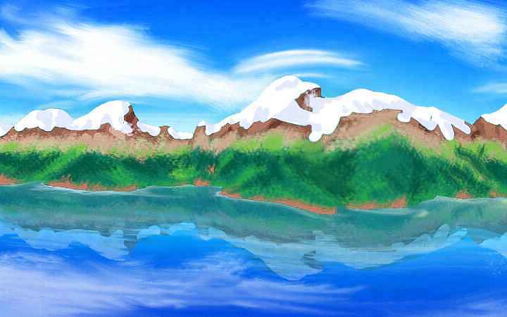
That blue, rugged line on the northern horizon, shrouded in cloud, is the Oborch Range, stretching east-west for 2400 km (1500 mi) along the north shore of Lannach.
Thought the Oborchs dominate northern Lannach, their crest only averages 2400 m (8000'), and is mostly frost-free even in orbital winter. Only a few peaks acquire snowpacks for a few months: Mt Brok, 3300 m high, Mt Salmen, soaring to 3600 m (12,000'), and the long ridge of Mt Oborch itself at 3200 m. The ch in Oborch is gutteral, closer to "orchid" than "orchard". Ironic, since it has more orchards than orchids--these scenic, more ecologically varied, cooler hills are heavily settled (by icari, tauraffes and sphinxes more than koreens); much of what looks like wild forest is in fact fruit and nut gardens. Few Lyrans think in straight lines and right angles; and the land shows it. To spot these Lyran sky-fields, you'd do better to look for color--strips and swirls of flowering tree-crops. All three species are fond of bright color, and select for this as much as for the flavor and yield of fruit.
You follow the Trolwen River northwest through rising hills, reaching Lake Brok at the mountain's foot by sunset the second day. You're glad to see open water, for it means fishing villages of icari, and a peaceful night's sleep--or at least quieter, gentler attempts at seduction.
Third day up the Trolwen: it's a loud white river now. All day you climb west with it, to its source on Mt Salmen. The mountains close around you, north and south; their cloudy heights block most of the region's endless storms, making the Upper Trolwen Valley surprisingly open and sunny for its equatorial setting.
Icari predominate, but for hours you fail to spot any of their eyries--up here they're artfully hidden among rocks. You don't realize why until you land near sunset in one and find an astonishing minority of quadrupeds living with the icari: antel! Surely the highest-altitude antel in the world, and they look the part: large, shaggy, deep-lunged and slim-waisted as grayhounds. Altitude, the cool climate, and sheer genetic drift in a small, isolated population may be shaping a new subspecies here. They certainly act differently: bold, relaxed, sensual, more like their icari friends than the shy deer you met in the far south.
Experienced travelers of Lyr's northern hemisphere will be feeling déjà vu, for this subspecies of antel bears an increasing resemblance to that hemisphere's dominant flying herbivore, pegasi. As the antel themselves put it in one of their Dickensonian haiku/proverbs:
"The niche molds the pelt."The question this raises is: what's our niche molding us into? How much of us is the result of big brains, language and tools, and how much is savanna, how much is the ice? Though that's an old-fashioned way of framing the question. As evidence grows for the tremendous speed of evolution in the (rare) cases of unequivocal selection pressure, the real question may be "How much did the farm shape us, how much the city?" Darwin was almost certainly wrong that we've removed selection pressures by caring for our unfit. I grew up having to drive California's freeways. Talk about eliminating the unfit! Rapidly changing times are exactly what triggers a Darwinian scramble. But how is it molding us?

Above you the slopes of Mt Salmen flame, well, salmon, in the alpenglow. The highest peak in the Oborch Range, its long alpine ridge reaches 3600 m (12,000') and forms a cool ecological island above even the mild Trolwen uplands--too cool for antel, even the Upper Trolwen subspecies.
The next morning you find out how cold it can get--your path heads straight over that ridge to the right of the peak. Soon you're exercising too hard to care about the cold--the real problem is, the air's so thin. What? On Lyr? Yes. Remember, with Lyr's higher gravity, air pressure drops faster--while there's still more oxygen up here than at sea level on Earth, your blood's thinned to adjust by now, and more importantly, you need quite dense air to fly in--your wings are small for your weight, by Earth standards. Down on the coast, in six atmospheres, flying may feel more like swimming, but at least it's possible. Up here, at a mere 2.9 atmospheres, you're struggling to keep above the trees! And not just you. Even the locals are maladapted to these chill cloudy heights. You spot exactly three icari and one antel... walking.
At noon, exhausted, you reach the summit ridge, "like stout Cortez with all his men, gazing at each other with a wild surmise, silent, upon a peak in Darien." Only if Cortez had to climb THAT slope in strap-on wings, he wouldn't be stout. You feel like you lost twenty pounds...
But it is a hell of a view. Behind and to your right looms Salmen, turbaned in cloud. The green slope sweeps down to the deep Achan Sea, cobalt blue in the high-noon sun. To the west, the shore curves north as smoothly as a vast flooded crater. No, it's not an impact basin--they don't last long on Lyr! It's just the first of a line of strange scalloped arcs to the north--the puzzling Ulwen Escarpments.
You dive down the long slope til the air thunders in your ears; every minute you have to pop them again, for at 200 kph it's not long til you're back in six atmospheres. After the uplands it feels as damp, hot, thick as glue.
DAWRNACH
The next day you head west along this steep, scenic shore to the Achan Strait. At the narrows, it's a mere 25 km/15 mi wide--a lovely, narrow sound with peaks up to three km high looking down on it.
But rather than follow it west to Sanga Bay, let's cross it instead. Before heading west, we have a side trip to make up the coast of Dawrnach, a land 2200 km long and 5-800 wide (1400 by 3-500 mi, twice the size of Madagascar. It's pronounced close to "dour gnaw" or "dour knock").
The great arc of Achan Bay curves endlessly north, and you have an easy day, just riding the updraft as the westbound winds are forced up over the ridge of the coastal mountains. Around noon, Mt Tamarin looms ahead: a long ridge 3500 m (11,600') high, rising steeply from the Achan Sea.
But late in the day the hills lower steadily. As the ridge fades, you spot silver sea to the northwest as well as northeast. You can sense Dawrnach sagging back into the sea--you've reached the northern tip of Diomedes.
Except... you're wrong. As the coast continues to curve, now northeast, it steepens again and the mountains rise. And rise. And rise! White gleams ahead. You refuse to believe it can be anything but cloud at first, but it's not. The Ulwen Range is high enough and far enough out of the equatorial belt (only ten degrees, but that's 2600 km) to bear real snow in the depths of orbital winter--though I admit, this is an unusually heavy snowpack. In fact, Salmen's summit tower may have had a few streaks--but it was so cloud-wrapped you never knew.
The three snowy peaks of Mt Ulwen are the highest points for 4000 km; soaring 4250 m (14,000') out of the Achan Sea. And that's only the visible part of the Ulwen Escarpment. This jagged, peculiar range twists like a broken-backed snake but extends underwater for thousands of km northeast, forming islets and atolls with extraordinarily steep dropoffs on the east side. It seems to be a tilted crustal block, like California's Sierra Nevada, but rather than end in a single great scarp, jagged keels and cirques rise from the depths--tilted, triangular wedges of crust overthrusting? If the sea were low enough to reveal the whole scarp, Ulwen would be the planet's greatest scenic wonder.
Whatever's causing these scalloped wedges to up-tilt, it's not unique to Ulwen; I mentioned the similar Driss Islands to the southeast, and the Dwyr Islands in Flandry, a group on the far side of the world.
One clue: The scallops diminish in size (if not steepness), as if they're deminishing echoes. What this reminds me of, frankly, is laminar flow--the twisting, curling turbulence of smoke, or Jupiter's atmosphere, or eddies in water around a disturbance. But this is stone!
Still, consider a real-life example right next door to us, on Venus. On its great continent Aphrodite is a huge arcuate structure, Artemis Chasma, like a backwards C. To the east (and linked to it by Diana Chasma) is a similar but somewhat tighter-curved backward C called Dali Chasma, one of the ruggedest rifts on the planet. To the east of that is a weaker third arc, Dzyzlan Chasma. The whole thing looks like the Paper Clip of the Gods, or a monster pretzel. (Note for purists: my maps of it show Venus terraformed, a thousand years from now. But the structures are quite real--and gigantic.) Such diminishing swirls in stone do look like the turbulence behind a storm on Jupiter or the ripples downstream of a rock. Planets, at least ones with relatively hot mantles and crusts, can apparently be elastic enough to display laminar curls.
Of course all this talk is partly to cover up that I can't think of any disturbance that travels like this through the mantle, leaving such a track behind. Unless the Japanese were right all along. That's one big, big catfish down there! I hope no one catches it soon. Shield-volcano scales, and magma blood! No, we don't want Maui the Fisherman to go pestering that. The bottomest of bottom fish. Not tasty.

A MUSIC EYRIE
The next day you climb into the mountains, where sphinxes and icari nest in the crags. You stay in an eyrie just over the crest, two km up. It's largely icari, but a large, mixed community, boasting a locally renowned music school with half a dozen species. They sing that night, and you're impressed; all that species-diversity lets them play with very wide harmonies.
A couple of species are new to you: one is a flightless feline centauroid, tiger-striped and tiger-graceful, massively muscled compared to all these gracile fliers. (Take a look in a mirror--YOU probably seem just as squat to the fliers here. They're built to save weight.) You don't get a chance to talk, but someone says she's a cheetaur, a people you've heard of... native to the far hemisphere!
Now that's musical dedication!
You wonder how long it took that student to get here--and how. Hitching rides on a trading vessel, maybe? You haven't seen or heard of any. But she sure couldn't walk, swim or fly here.
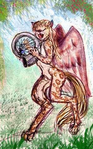
The other new species new to you is a sphinxlike creature with a lighter build, a more catlike face, leopard spots, and the long hind legs you'd expect on someone who often walks upright, if not all the time. A lebbird, named Atoll, for her ringlike spots, she comes from the far west. Most of the time, she hides up in the trees, coming down only for meals, recitals and dances; her species is arboreal, feeling a bit lost on the ground.
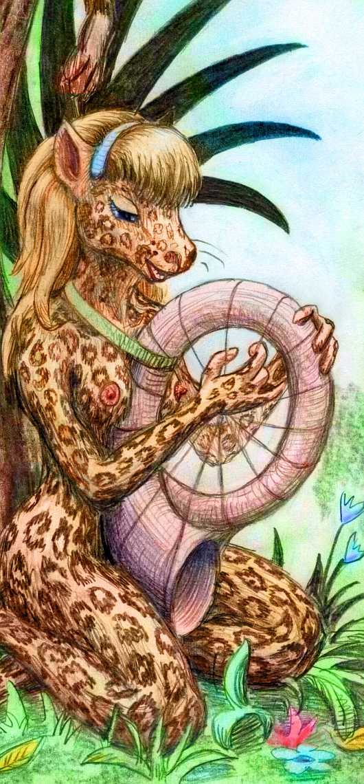
Besides singing (but then all Lyrans sing) Atoll's a harpist. Her instrument is beautiful but peculiar: a spiral of strings wrapped around a huge nautiloid shell, shimmering with muted rainbows like abalone. You think "Terran guitars may have mother-of-pearl inlay, but this goes a bit overboard!"
Until you hear the tone. The resonator is all one piece, and it rings--a bell-like, amazingly deep and rich tone for such a compact design. Well, conch shells make decent horns, after all. "The problem," Atoll tells you, "is that they're prone to chipping." The moment she's done playing, the shell goes back in a soft slipcase. And she slips back up into the trees... Arboreal girl.
The next day, you leave the music school--reluctantly, but there's a long way to go yet. You glide west down the Ulwen River. Storms at this latitude mostly roll in from the south and east, but the Ulwen Range catches them, leaving this the driest land on Dawrnach. It's still no desert, but the open monsoon forest frays into savanna in spots, forming an ecological island of near-Mediterranean climate bigger than Greece. Sphinxes especially like this drier climate, and you spot several villages in crags and rocky coves. And floxes farm the canyons wherever the walls let them dig out their distinctive cliff-dwellings.
But you also spot several whole bands of cheetaurs! The singer last night wasn't a foreign exchange student, but a local girl--using "local" loosely, of course. She merely had to walk a couple of hundred km, then scale the Ulwen Alps on foot... that's all.
Lyr's not so easy on the flightless.
It turns out these cheetaurs descended from a single shipload of emigrants from distant Erkila, bound for Cape Rodonis (the very edge of their known range), four thousand kilometers west of us! Storms blew them across the Rodonis Sea to the Ulwen Islands. The local koreens had never heard of Cape Rodonis, but they did know of a nearby savanna. "By all means settle there if you can use it." Generous of them--considering koreens find savanna uninhabitable!
In the long run, getting lost was good fortune: these meadows are ideal cheetaur habitat, and there's no competition for the niche, unlike the lebbirds' situation. The upland antel of the Oborch Range might have claimed it, eventually--if they'd ever learned of it. Unlikely--they're separated by 1000 miles of steamy jungle quite unsuited to antel. So this lost boat of cheetaurs may be the seed of a new civilization more or less by default!
At least they're not Puritans.
A SWING DANCE

So far, I've only given you a sketchy picture of koreens. My bad! My bias, to be honest--I'm an introvert, and koreens are loud, social folks. That doesn't mean they're stupid! Let's stay up tonight--there's a swing dance. No, really, that's what they call it--with better reason than humans.
Three villages meet--some 500 koreens roosting in platforms atop trees 60 m tall (200'), around a small clearing with a few overhanging branches and many long vines. You didn't pay much attention in daylight, but it's an unnatural set-up--in fact, quite carefully tended. This gap in the trees with vine "ropes" is in fact a dance hall.
The swing musicians gather on the platforms round the rim, with their didgeridoos. Not identical to Terran didges, but they are termite-hollowed branches, with equally complex resonance and a "talking" sound. However, each has four fingerholes, allowing a pentatonic scale, and each horn's in a different key, so a group can play complex harmonies (and fur-raising dissonances, if they're that sort of musician, and many korrens are. Or become so, if you slight them. Koreens, like parrots, like and expect attention, and they're loud--after all, they communicate long-distance through the canopy by sound. So an insulted koreen is not subtle. Earsplitting dissonance--and that's one koreen and no didge.) I hope you remembered your earplugs.
The torchlit dance begins graciously; couples bow (koreens pair-bond much as humans do: that is, monogamy's the professed ideal, though the reality is far more complex). The couples swing into the center like trapeze artists, meeting and parting, meeting others, rejoining their mates to swing away again. It tellingly parallels their love lives, of course, as it's meant to. Negotiations are going on in this looping chaos! But only a koreen could follow the patterns of this three-dimensional dance.
And soon a new phase begins: the swooping and the didges' roar sends the vine-swingers into a moving trance. They swing beyond their personal concerns into a communal dream. The dyads fade, replaced by intricate snowflake patterns. Unity!
Meanwhile, the musicians breathlessly playing these instruments bigger than themselves slowly slip into a hyperventilation trance! Their visions guide villages much as shamanic dreams do in many human tribes. Every band has a note-taker who questions the musicians about what they saw and reports it to a sort of dance-debriefing committee later.
Yes, of course koreens are literate--I'm making them sound Stone Age (and given the metals shortage on low-density Lyr, that's nearly the case) but they have a sophisticated literature and long written history. Indeed, they were probably the first people on Lyr to invent writing--their fabric designs and woven-hut patterns incorporated symbolic glyphs, which evolved long ago into pictographic and then syllabic bark-writing. Ink-grinding stones thirteen millennia old have been found, though no actual samples of such early writing on fabric or bark paper have survived--the koreens' homelands are just too humid.
Even today, such ink-grinding (and nut-cracking) stones have a mystical significance among koreens. Carried everywhere in their marsupial pouches, such stones are signs of identity. And a bit like wedding rings, too: when a baby's born and the mother thus has to stop using her pouch as a pocket for a few months, she clicks stones ritually with her mate, who then carries hers as well as his until the pup's ready to leave the pouch, when he gives her his old stone, keeping hers. (A male known to carry several stones is both scandalous and perversely admired.)
Well, maybe that's more than you wanted to know. In the morning, you don't hang around for the post-dance meeting. You don't really need to watch village policy (and couples' commitments, and teen angst) get trimmed to face the reality revealed in the dance-trance. Time to fly on. Still half a continent to see, after all!
Two hours southwest, over a range of hills, out of the Enklan Basin. Down to the west coast of Dawrnach and along it all day. Low and green, low and green... the trees higher than any hills.
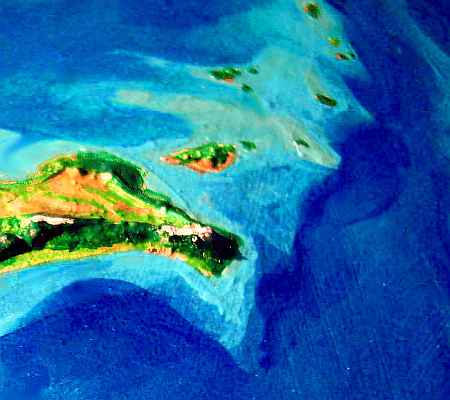
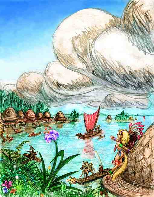
The next morning, a sudden channel yawns before you, fifty km wide (30 mi): the mouth of Sanga Bay. This island-studded, branching inland sea is 900 km long and up to 300 wide (550 by 190 mi). It separates Dawrnach from the Lannach mainland to the south. Its many islets and sheltered coves harbor sphinx and icari fishing villages.
DUNA ISTHMUS
You're nearing the end of Lannach now. Three long, dull days, flying west-northwest from Sanga Bay along the Duna Strip. Duna is a neck of low hills 15-1800 km long (1000+ mi), linking the continent of Lannach to its satellite Holmenach. Duna's a strip of tropical rainforest, but it's no skinny Panama--the narrow west end is still 270 km (170 mi) across. It's classic tauraffe-koreen country; near nightfall you head for the coast, hoping to find non-koreen villages. No luck the first two nights--it's a low, wooded mangrove coast, with no rocks or cliffs such as icari and sphinxes love.
But the third evening, you stumble on a cove full of gigantic derby hats on wood stork-legs, standing in shallow water. The brims apparently serve both as shade-verandas and landing-decks. An enterprising group of sphinx fishers has tried something new here. You sleep in quiet comfort, not bobbing with the wind in a koreen hut high in a tree. The waves lap beneath you, your hosts purr beside you. And you decide, sleepily, happily, "the experiment works."
Duna Isthmus is broad, and there's no strait or range or watershed to mark the end of Lannach. Might as well take this mangrove-cove to be the border. A cultural watershed? Maybe things get more experimental, in the west, in...
THE THEONAX BASIN
Holmenach, the western subcontinent of Lannach, is nearly the tail that wags the dog--a huge wedge of tropical forest some 3000 km (2000 mi) on a side, anchored by the spectacular Delp Mts on the west coast--the geological spine of the whole Diomedes Cluster. To the south over Orikan Strait is similar Kilnu, nearly as large, and part of the same formation.
At first the land seems no different. In fact, a day later, you'd swear Duna was narrowing to a point and ending ahead: riding the updrafts along a modest range of east-west hills, you spot water to the southwest as well as northwest. Veering left, you slip down the gentle slopes to have a look at this new coast.
It seems like an ill-defined "mangrove" shore of the Drakho Sea, all right. But as you wheel lower like a curious gull, you realize it looks different, smells different... You're only sure when you land on a great, bleached log and taste the water. Fresh!
This isn't the sea, but Lake Theonax, largest lake in the world, 5-600 km long and 2-300 wide (3-400 by 150-200 mi). Theonax drains a vast basin. It grows and shrinks annually, rising several meters during the heavy monsoon rains of orbital summer.
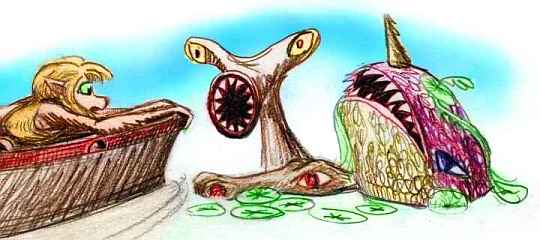
These muddy, tannin-stained waters hide a number of large species with ingenious solutions to the pea-soup problem. Some sense polarized light like bees, some use electrical fields, some sonar. Some just bite anything they touch. A fascinating ecology, but swimming is not recommended.
Anyway, Theonax isn't the end of the jungle, but its soggy heart. Beyond the great lake sprawls yet one more jungle plain days wide, broken only by long, straight ridge of the Rijn Hills.
Both parts of that name are rather deceptive. It's just pronounced "Reen," and they're only hills in contrast to the high Delp Mountains beyond. Anywhere else on Lyr, the Rijns would be respectable mountains: the highest peaks top 3 km (10,000') and are often snow-dusted in orbital winter. Still, most are more like 2 km (6600'), with their heads in the equatorial cloud-sea, not above like the Delps. The east end of the range forms Cape Rijn, 600 km (400 mi) long, sheltering Rijn Bay, the northern tip of the shallow, coral-filled Drakho Sea.
But let's head northwest along the shore; I've had it with muggy jungle interiors. Though we can't see them yet, ahead rises the Delp Range--a whole different world!

You find another sphinx hat-village near dusk, at the mouth of the wide Theonax River, the lake's outflow. This one has landings below each hat-hut, for small boats; evidently even sphinxes won't risk diving like pelicans into that murk. You might brain yourself on something. Something with teeth.
The next day you head almost due west, first along Theonax's north shore, then above tall forests. Slowly it rises, opens and dries a bit from the swampy Theonax Basin.
By late afternoon, when you reach the Rodonis Sea coast, it's open, airy monsoon forest. Now, in winter, the winds blow steadily off the land, and rarely bring rain, for we're no longer in the year-round equatorial rainbelt. Though our sideslip north's been imperceptible, masked by weeks of mostly-westward flight, you're nearly as far from the equator now as the golden Ulwen Valley with its cheetaurs. Koreens and tauraffes still abound, but icari and sphinxes are now quite common.
Near sundown, the land abruptly ends. Lurid sky, lurid sea. A line of black hills wrinkles the western horizon, silhouetted in the sunset: the Isle of Ness.
We've reached the mouth of huge Ness Bay, a squarish bite 500 km across taken out the north coast of Holmenach. It's quite deep--clearly a geological reaction to the young, high and still-growing Delp Mts to the west. It may be a dropped fault-block like Earth's Death Valley, just much bigger: Lyr-sized. The shores are hilly and look rather Mediterranean, with open meadows on the bluffs and groves in the valleys.
It almost looks open enough for cheetaurs, and in fact you meet one or two; pioneers from the lands ahead.
But that's another tour! Two short tours, in fact:

TOUR LYR! The following route snakes around Lyr, covering all major features:
Ythri -- Polesotechnic Chain -- Troisleons -- Roland -- Oronesia -- Gaiila -- Flandry -- Diomedes -- Ak'hai'i -- Averorn
World Dream Bank homepage - Art gallery - New stuff - Introductory sampler, best dreams, best art - On dreamwork - Books
Indexes: Subject - Author - Date - Names - Places - Art media/styles
Titles: A - B - C - D - E - F - G - H - IJ - KL - M - NO - PQ - R - Sa-Sk - Sl-Sz - T - UV - WXYZ
Email: wdreamb@yahoo.com - Catalog of art, books, CDs - Behind the Curtain: FAQs, bio, site map - Kindred sites