Southern Diomedes
by Chris Wayan, 2006
dedicated to Poul Anderson for his remarkable world-building
Lyr (home) - map - creatures - cultures - evolution - climate - geology - gazetteer - nomenclature - definitions - building Lyr - more worlds? Planetocopia!
INTRODUCTION
New on Lyr? First-time orientation--strongly advised! Lyr is weird.
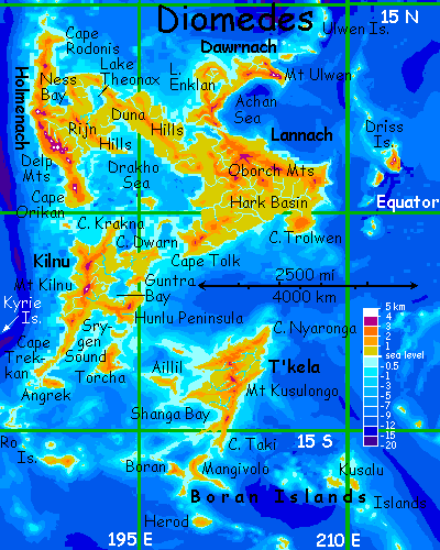
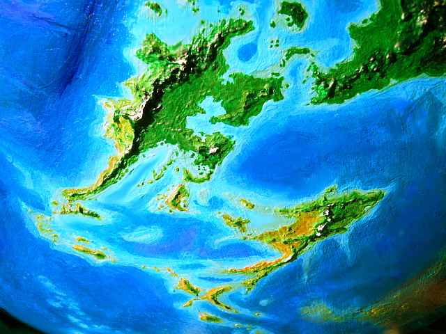
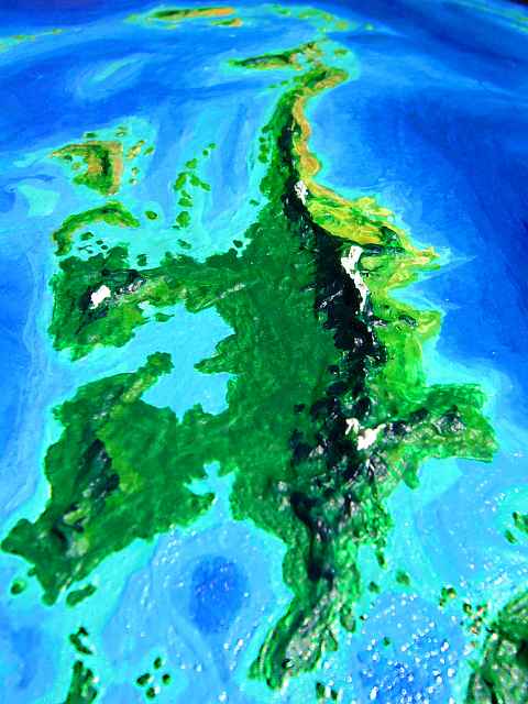
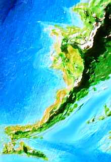
Diomedes is one of Lyr's biggest land-clusters, with 14.5 million sq km (5.7 million sq mi), nearly as big as South America. The main continent is Lannach, linked by an isthmus to Holmenach; together they total nearly 8 M sq km (3.1 M sq mi); the main satellites are Kilnu, T'kela and Dawrnach. The Diomedes cluster is biologically quite isolated; while flyways do run north to Roland, and east to Ak'hai'i and Gaiila, and west to the Polesotechnic Chain, every one is long and grueling.
| Lannach: | 2,000,000 sq mi | 5,000,000 sq km |
| Holmenach | 1,100,000 sq mi | 2,820,000 sq km |
| Dawrnach | 500,000 sq mi | 1,260,000 sq km |
| Kilnu | 1,000,000 sq mi | 2,600,000 sq km |
| T'kela | 750,000 sq mi | 1,920,000 sq km |
| Lesser isles | 350,000 sq mi | 900,000 sq km |
| Total area | 5,700,000 sq mi | 14,500,000 sq km |
The South American comparison wasn't idle. If you scooped up T'kela and Dawrnach, and dropped them in the central Drakho Sea, you'd get a continent much like South America! Triangular, equatorial, wet, lush, with high mountains on the west coast, low ones in the northeast...
But this is Lyr, so it's not just a fractured Brazil: there are multiple intelligent species flapping around the jungle canopy.
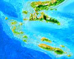
THE KUSALU ISLANDS
We'll start our tour in orbital winter, when the region's a bit cooler and drier. Let's enter the Diomedes region the way most Lyrans do: crossing the Ikt'hanis Ocean from Gaiila. The Ikt'hanis (meaning roughly "most oceanic" or "oceanest" with a female ending--"Mother Sea" perhaps, as we say "Mother Earth") is large and islandless: 135 million sq km (53 million sq mi), nearly the size of the Pacific, and much deeper. The Ikt'hanis isolates Diomedes--only one grueling flyway 8000 km (5000 mi) long crosses its south end from the Gaiila Cluster: from Carnoi to the Nadi Islands to the Kusalu chain to the Borans to T'kela. Sound long? It is.
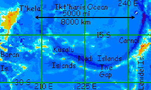
So... you're mid-ocean, hopping along the Kusalu Chain, which begins as a line of islets and atolls along the Nadi Trench. The Kusalus are geologically just the half of the Nadi chain west of a gap some 1300 km long (800 mi) with mere seamounts. The gap is a 14-hour flight at best, and longer with headwinds. It's not the only risk for fliers here--the Kusalus are in a drybelt. Fresh water can be hard to find on smaller islets. (That's why so many travelers detour south through Ak'hai'i and Rorvan instead, a route that's longer still--around 16,000 km (10,000 mi). At least drinking water's reliable all the way!)
But the first few days are the worst. The Kusalus grow larger to the west; the biggest two, East and West Kusalu, are (despite their names) both near the west end. They're each around 260 km (160 mi) long and half as wide, with hills high enough to catch some rain, though most of the lowlands are savanna. Here you expect to rest and rehydrate for a few days.
Well, you were half right. You do find water--but no rest.
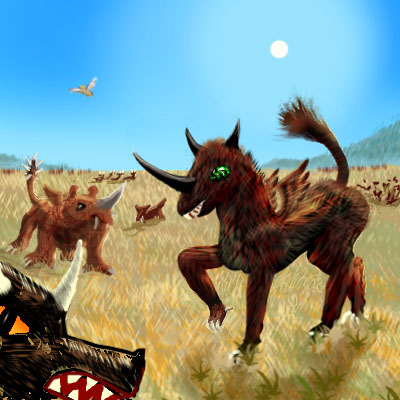
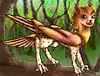
Why? Instead of the island dwarfism often seen on Earth, creatures on the larger Kusalus run big, ugly, and mean, for their wings have become vestigial. Lacking the weight limits imposed on fliers, they were freed to indulge in a savanna weapons race--horns, frills, dorsal spines, fangs, spiked tails, and the big muscles needed to move a heavy, armored body fast in high gravity. East and West Kusalu look like a cross between the La Brea tar pits and Ngorongoro, with Komodo Island thrown in for fun. On most tours of Lyr, it's easy to forget that the gravity's higher than Earth's, because you've been among fliers and arboreal people with light builds and hollow bones, under strong evolutionary pressure to keep their weight down. On Kusalu you face the squat, thuggish reality of hi-grav life.
Fighting with these monsters over muddy water at wells and waterholes just adds to the delights of the Kusalu Passage. And the fun's not over; even after West Kusalu there are two more days of semi-arid islets, then a ten-hour nonstop flight (nearly 1000 km/600 mi) to Mangivolo.
Mangivolo is a relief. The largest of the Boran Islands, it's nearly as big as Cuba--a graceful curving ridge 1000 km (625 mi) long. Its long spine creates ridable updrafts the whole length of the island, and the ridge is high enough to catch rain, sustaining oak woodlands. The east coast resembles the Mediterranean, but the lee coast to the west is a treeless veldt, near-desert in spots. Mangivolo and its neighbors like Boran lack the flightless giants of Kusalu--only two or three hours off the mainland of T'kela, they're just not isolated enough. And you're glad they're not. Back in civilization! Welcome to the Diomedes Cluster.

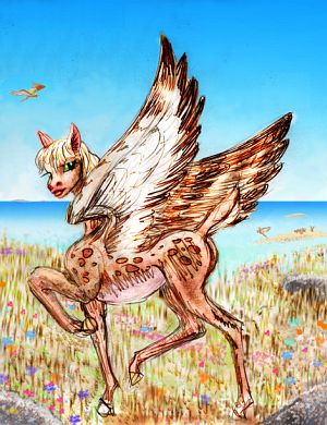
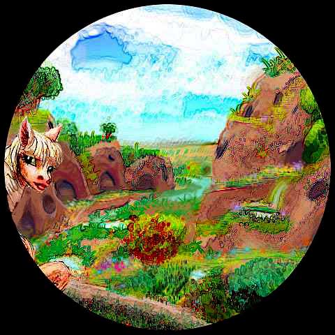
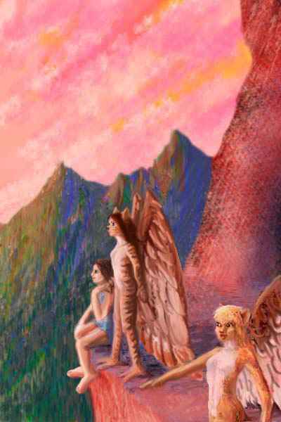
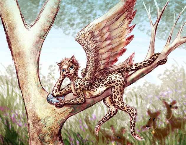
On Mangivolo we meet a flock of icari, creatures like furred cat-faced angels, who are heading south to the Rorvan Archipelago and the Ak'hai'i Region beyond. A few are even going on to visit the experimental gryphon settlements in remote Averorn, southernmost of all habitable lands. I warn you the flyway isn't easy--the jump to Ak'hai'i is 1800 km (1130 mi), with not a rock to rest on!
But the icari have lovely tortoise-shell fur, and are famed for their sensuality, and seem very friendly--so you're tempted. It's up to you.
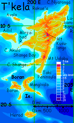
T'KELA
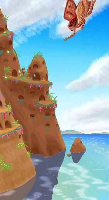
You make landfall on Cape Taki, the southern tip of T'kela, a strip of low hills 450 km long and 160 wide (280 by 100 mi). The land's rather Mediterranean--meadows, aromatic scrub, and scattered groves. Rocky outcrops above perennial streams are often hollowed out into icarus villages. The bottomland's densely wooded, and looks wild at first, but in fact these are orchards mixing dozens of varieties of fruit and high-protein nuts.
An hour or two later, as you rise with the hills and your horizon expands, you can see brown humps to the west over Taki Bay--Cape Shanga, the driest part of T'kela, a rocky ridge 600 km long (375 mi) but as little as 50 km (30 mi) wide. It's true desert on its far (west) side--bare red crags dropping into a coral sea. Rich fishing grounds--the icari may have evolved along this dry coast, fishing off sea-stacks. The reefs continue out 1000 km to the western Boran Islands.
This long straight line parallels at least three others crossing T'kela from southwest to northeast; they resemble deep-sea fracture zones, but if so, then the Kusulongo Range along the island's spine (the hills you're flying above right now, riding updrafts they generate)... the Kusulongo Range should have a spreading rift valley, and it doesn't. T'kela may be a region of sequential compression, that is, squeezing first in one direction, then in another about sixty degrees off (with hints, in offshore ridges and islands like Mangivolo, of a third set of faults set sixty degrees from both). Or it could be sequential shearing as in Earth's fracture zones, though both the cause and the odd angle(s) are a mystery to me. Above OR below water, few Terran landforms look quite so crystalline and ribby--but it's worth noting that some regions of Venus look similar, like Asteria and Hecate Chasma in the Beta region. Are these splintered little plates like Earth's Cocos or Philippine Plates, or do plate tectonics apply at all on Lyr? Is this mere random scum floating on the surface of a hot, churning mantle?
Maybe I'm reading patterns into chaos.
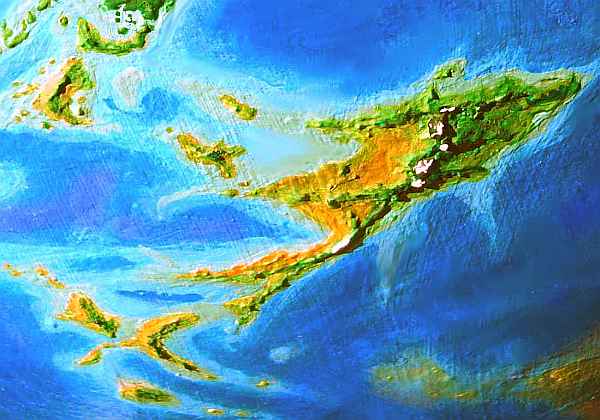
But look again at that consistent hexagonal fracture-pattern sprawling over two thousand miles, with ridges kilometers high. It shows up from space, even in this orbital photo, despite its foreshortening and low resolution. "Something's happening here, though what it is ain't exactly clear." (Be glad I didn't quote Dylan's "Mr. Jones" instead--"Somethin' is happenin' but you don't know what it is, do you, Mr. Jones?" Because that would lead to a one-eyed midget calling you a cow... I kept it clean. This is science!)
Where were we? Oh, on T'kela, flying north over that weird ribby landscape, bare to your gaze, like bones dried in the sun...
But as the hills rise, they grow greener. Though it's stolen rain--the coast to the west grows even drier. Ahead rises a peak dark with evergreens--Mt Uolobu, the highest in southern T'kela at 3200 m (10,700'). Uolobu is a long high ridge across the prevailing winds, so its rainshadow to the west along the shores of Shanga Bay is a true desert. You can't see all of Shanga Bay (it's a triangular gulf some 800 km wide) but the shore below you is has only dry grass and bare rock. The Shanga River Basin to the north is over 100,000 sq km of the same. It sounds uninhabitable, but this dry veldt, basically Kusalu without the monsters, is heaven for a species that in fact inhabited the Kusalus, too, though you never saw them: the antel. These shy, nervous deerlike creatures are (understandably) especially elusive in the Kusalus.
But on Shanga Plain, antel herds graze openly, in peace. Its wide flats are a major center for "kickrock" stone-drawing, an antel art form in which hundreds of stones are kicked and tongued into lines that form huge dotted drawings viewable only from the air. Some are even visible (if badly foreshortened), from here on the slopes of Uolobu--flowery graffiti scrawled on the golden veldt.
As you continue north, the highlands grow misty and lush, even more of a contrast to the dry plains to the west. I first wrote "below", but now that'd be a lie. On your left, the lowlands are still dry; but to your right, the mountain forest now reaches down to the eastern sea. We're creeping out of Lyr's drybelt--analogous to Earth's desert-prone latitudes, but narrower. Lyr's fast spin makes its climate belts quite stripy.
This coast of T'kela is too dense for the nervous antel (who like a clear view of possible predators), but it's prime orchard land for the icari. Some villages here are built in treetops instead of crags. They borrowed this design from a third people we'll soon be encountering, in the northern rainforests--koreens.

Past Mt T'kela, two miles high but invisible in mist, it's all cloud forest. But ahead you get a rare clear view of Mt Kusulongo, the highest peak on T'kela--3700 m (12,100'). Lakes at its feet give rise to the two longest rivers on T'kela, the Lubambaru and Mirzabad. It's pure icarus country--neither koreens nor antels like these cool uplands, but icari evolved to dive into cold seas. In their fur, a cloud forest doesn't faze them a bit.
You stay as a guest in an icarus eyrie on a crag mirrored in the still waters of Lake Mirzabad, like a Stone Age parody of Mad King Ludwig's fairytale castle. But these aren't the Flintstones. After sunset, the younger icari start an impromptu concert of folksongs; duets and trios with close plaintive harmonies. It's haunting music, half Appalachian half Balkan. Those of you who have toured western Gaiila will have a sense of deja vu. The icari on Tau came from here, long ago; their striped pelts, their lakeside crag-keeps, their rich musical traditions, all originated here in the Kusolongo highlands. On the world map these clusters are neighbors, so you may wonder how much contact's maintained between homeland and colony. Next to none! It's a journey of 19,000 km as the icarus flies (12,000 mi). Caracas to Singapore, or Boston to Perth! Lyr is big.
Downstream from the keep, the Mirzabad River runs 800 km (500 mi) west to the sea. The Mirzabad Basin is antel country, savanna with only scattered groves; though we're in a rainier belt by now, the high Kusulongo Range still casts a rainshadow.
But our way lies, around the great peak, into a greener land: the Lubambaru Basin, a rainforest twice the size of Florida (300,000 sq km, 120,000 sq mi) dominating northern T'kela. From Lake Kusulongo at the mountain's northern foot, the river flows 750 km (450 mi) northeast. It's an easy downhill skim for us--the sun's still well up when we reach the delta.

Here we stay in a treetop village of koreens, in houses like baskets skewered onto treetrunks 30 meters up (100'). It all looks flimsy, but bears your weight--it has to withstand worse than hurricanes, after all--it has to withstand 200 koreens! They may be small, but they're rowdy, acrobatic, playful, and as loud-chattery as a parrot flock. Quite a contrast to the icarus crag-eyries full of choral music, or the silent, artfully hidden antel shelters, over on the dry west coast.
But familiar just the same. Elsewhere on Lyr, you've encountered nearly the same pattern--woven, swaying treetop villages full of loud, friendly flocks of little parrotlike people. Only they were griffets! It's not coincidence, yet the two species aren't related--in fact, whales and weasels are probably closer kin! They don't even look similar--griffets are a bit like winged housecats, while koreens are feathered monkeylike marsupials. It's pure behavioral convergence, due to a similar niche in their respective tropical rainforest canopies.
The next day, you decide not to fly all the way up to Cape Nyaronga, the northern tip of T'kela. It's the rainiest part of the island, and we'll be getting plenty of that soon enough. Instead you head west up the Rokue'a, a tributary of the Lubambaru. Even that's a trip punctuated by showers all day. But rainbows come out within minutes each time. By sunset, we're in the uplands again, amid tattered cloud-banners. Beyond the summit, the western sea glares crimson in the sunset like a lava lake. Off to the north loom the craggy hills of Cape Rokue'a, a rugged peninsula 160 km (100 mi) long. From here you can't see the Isle of Rokue'a off its tip, about the same size--bigger than Bali and nearly as green.
In daylight next morning, you notice this whole coast is open monsoon forest--drier than the Lubambaru Basin, where open meadows are inconceivable, but still quite green. We've come a long way north into the rainbelt.
Just in time to leave it! You head south across the base of Cape Avolo. The mountains stay forested, but the hills and plains slowly open into savanna with green veins--the Mirzabad Plain. If you flew all day up the right tributary, you'd reach that icarus eyrie on Lake Mirzabad.
But these plains are unsuited for icarus eyries--indeed, despite the antel herds, you see no homes at all. Are they true homeless nomads, like the deer they resemble? But toward evening, you spot a flock of antel settling in a rocky draw below a bluff where rivers meet. You spiral in, curious, and find a canyon-garden with discreetly hidden cave-mouths. They welcome you, shyly but warmly--none of the fear their relatives had, back in the brutal Kusalus.
Most antel architecture looks like this: natural rock shelters only subtly enhanced. This minimalism may have grown from the practical limitations of their tongue-hands, but it's become the antel esthetic, too. Right angles and symmetry are in bad taste, found shapes and local materials are de rigeur. It's not Zen, but Zen and antelity could get along. Typically, small terraces double as landing platforms leading into airy caves, above a creek feeding a string of pools, often as small as bathtubs. If it has tiny waterfalls, antel find it irresistable.
Dusk. Lamps are lit, and their warm light washes the caves. Oval windows breathe cool night air. Quiet conversation. A poet recites. A young doe tells a story, acting out the parts to a rapt audience; the tale of an interspecies romance, which, though doomed to be brief, changed the souls of both lovers. It's only as the story ends that you realize how many antel are eyeing you openly, in this shy culture where eyes always drop. You're being flirted with--by half the antel in the valley! In fact, this quiet evening is an antel party in your honor. No traveler's guidebook can advise you here. You decide how you feel about winged, big-eyed antelope with sharp little hooves, who like to talk poetry. But show respect. What a stretch they're making! Looking past the skin of a scary, upright, bald, squinty-eyed predatory ape, to see the spirit beneath. Can you?
Whatever you choose, respect the courage in their shy hearts.
When you next take wing, whether it's after days of a disorienting alien fling, or the next morning after a quiet sleep... whenever Lyr starts calling you to take wing again... you head southwest, a full day, out along Cape Akulo, a broad wedge of savanna, with trees only on hills and along streams, separating Mirzabad and Shanga Bays. Icarus eyries top the cliffs all along Cape Akulo.
Akulo ends in a spectacular 100-km (60-mile) cliff-walled strip, like a petrified aircraft carrier. This ridge extends offshore--cliff-walled islands and sea-stacks stretch another 100 km out to sea, until they're drowned in the glare of the setting sun. If this is your flyway, you're too tired to take it.
You crash (almost literally, but not quite) in a cliffside village--not of icari, as it happens, but a fishing colony of sphinxes. They're rare here, but a few have migrated from Gaiila. They're welcoming, empathetic, sensual, and so beautiful they override any qualms about their alienness. The trouble is, you're too tired to even recognize half the sphinxes are flirting with you too, let alone respond with more than a "Huh?"
Very romantic of you.

Well, there was one sphinx whose flirtation you couldn't miss. Sphinxes are excellent artists--and art lovers, for they mentally fall inside images, readily see them as windows into other realities. They exploit this trait socially; where a human might offer a date flowers or a poem, a sphinx offers pictures; even an interesting conversation may drive a sphinx to scribble cartoons instead of notes. The artist sketched here was busy sketching you, as well as her impressions of your homeworld, Earth, as you spoke of it. Then she rolled and wiggled on the drawings just to make clear how much conversing with an alien turned her on. Not subtle!
At dawn, you listen closely to her advice (on geographic orientation, even if she's left you with a certain sexual disorientation). She warns you "Veer north from the pointing finger of Cape Akulo, bridge though it seems. The real flyway heads west-northwest over open sea."
Two hours later, over a fatal, featureless azure sea, you're getting nervous. But trust a sphinx for navigation! Soon rocky hills poke over the horizon--Aillil, a dryish island 550 km (350 mi) long. You rest and have lunch on the shore by a creekmouth--at least there's some water. Few trees, though; the coast is savanna, where antels graze and compete in their megalithic connect-the-dots games.
All afternoon you climb inland past the stone cartoons of the plains, into hills with patches of open monsoon forest. Though it doesn't look it, these are orchards. Most of the locals are koreens. Craving peace and quiet, you avoid the koreen rookeries and press on until you come across an icarus eyrie to sleep in; that sphinx artist told you there were a few in upland Aillil.
You feel better the next day, and make a leisurely trip down to Cape West, camping less than an hour offshore on little Farewell Island. Though you reach Farewell long before dark, you stop early--you've been warned to rest up for tomorrow's long flight, for you're leaving Greater T'kela at last, for...
GREATER KILNU

You take wing before dawn. It's 5 hours west to Torcha, and if you wait until sunup, the last hour or so it'll be glaring right in your eyes... A dull, strenous day of steady flight over a featureless sea. At least the weather's good--but then you expected that, here in the drybelt. Late that afternoon the cerulean sea turns turquoise again and the hills of Torcha rise into view.
Torcha's a rugged L-shaped land nearly the size of Ireland--600 km long and 250 wide (380 by 160 mi). Most of it is a subtropical plateau over 2 km high, with a mild, cool climate. Here we meet our first tauraffes (there were a few villages on Aillil, but you didn't pass one. Believe me, you would have noticed one. Tauraffes are big). Big enough so they're little concerned with modest temperature changes--much less skin per kilogram to lose heat through! Tauraffes evolved in the equatorial rainforests to the north, but they're as climatically adaptable as elephants.
At first you follow a narrow, hilly cape. It climbs steadily without widening. To the right, though, pale shallows and islands appear, one quite large. Torcha Bay! You'll be skirting it all day.
You climb steadily into the hills. They look spiky--the "spikes" are the towering conical wooden barns of the tauraffes, up to ten meters tall--too big to call huts, too crude to call houses, but adequate for a people wanting tool-storage more than warm shelter. The Torcha Plateau is a maze of open woods and thorny brush--no, orchards and gardens. Fruit trees and berry patches! Thorn hedges towering over a human are just waist-high to a tauraffe--a comfortable height to harvest from. You feel small, and realize how strange human gardens must look to rabbits and songbirds.
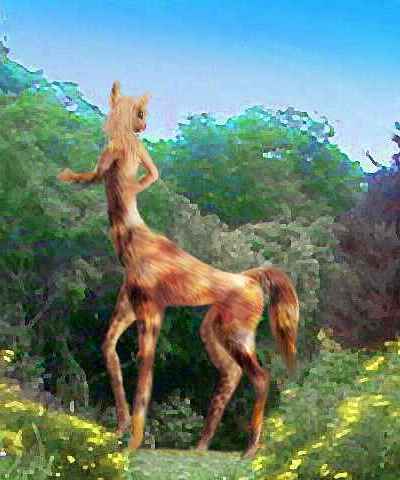
You curve north, up the plateau, and start to get worried. Tauraffe barns don't seem like good shelter for humans. And you don't want to get squashed by a sleepwalker! A tauraff harvesting nuts waves and calls. You land awkwardly on a walking-path--no landing platforms here, this isn't country built for fliers. Only now do you realize that Lyr, though it's seemed primitive, especially in its transport system--no roads, no railways, few ports--has a subtle, vast infrastructure you took for granted. Even you, a clumsy flier in strap-on wings, could always find a place to land--in jungles, deserts, rugged mountains. And wherever you landed people took you in without question. It's only now in Torcha, a land shaped for walkers like yourself but on another scale, that you first feel alien and lost. Yet isn't this how Earth would seem to you, if you could fly in its thin air? Is this how Terran birds feel, struggling to fit into the cracks of a world shaped by giant flightless mammals?
The tauraffe greets you, speaking slowly but in quite standard Trade. The booming bass voice makes your Earth brain assume it's a man, but a discreet glance shows you're wrong.
"Lost? Need shelter for the night?" says this woman eighteen feet tall.
"Not yet, but soon."
"An hour ahead as your people fly, the hills drop, and you'll find warmer woods with koreens..." Oh joy. Shrieking monkey-parrot parties all night! "... and icarus eyries on the coasts."
Now you can say "Thanks!" and mean it. Strange, but you get an impression of great sweetness and benevolence from this huge being--as if tauraffes can't conceive of having an enemy in the world.
Maybe they can't. Did they ever have any natural predators? Tool-using giants, now there's a group to avoid!
You trundle clumsily back into the air, your wings brushing the crops along the narrow path. But you break free, airborne, and stagger back up to cruising altitude. Still, the near-crash warns you--this country, built by nonfliers, is as deceptive as coral reefs, and a refuge only to the naive eye of a tired, amateurish flier. Choose wisely, for wherever you land next, you'll be there all night. You'd better hope that tauraffe was right.
As the sun gets low, you do begin to descend at last into hotter country. Still plenty of tauraffe structures, but you find a crag hollowed into a quiet icarus eyrie with broad landing-ledges and terraces. You collapse in relief. Smiling cat-faced angels watch a wild sunset with you, then feed you soup and sing a bit and go to bed and aren't too pushy about offering to go to bed with you, despite their obvious curiosity, and you are utterly grateful, and sleep right through until late morning--a shocking eight hours.
The crossing from T'kela was harder than you realized.
The next day you feel so much better you almost wish you'd taken up some of those offers, particularly from that very cute singer.. but you have a billion square miles of alien world to explore. On, on!
Still, you take it easier today, and your body is grateful. It's an easy glide out to Torcha's northern tip. Visible over a shallow strait less than an hour wide are the hills of Nua, a low, narrow crescent of rainforest 320 km (200 mi) long. Nua is a remnant of an eroded landbridge from T'kela to the central Diomedes Cluster, a shorter one than the flyway you took--from T'kela it leads due west to the Isle of Avolo, then to Nua. I went around it because it has a gap over 1100 km wide (700 mi) with only reefs--no safe landings at all. You aren't a native, and the five-hour deepsea flight from Aillil to Torcha seemed safer than one over twice as long. If anything, those reefs give you a false sense of security. You can drown in three meters of sea as easily as a thousand, especially tangled in the ruins of your wings.
There's even a civilization of sorts down there--an intelligent marine species called hexanauts, six-limbed nautiloids (like shelled octopi) build houses and use tools on those reefs. hexanauts are friendly enough, that's not it. The partial pressure of nitrogen in Lyr's dense atmosphere is already enough to cause slight giddiness in some Terrans. But the added pressure of even a few meters of water under high gravity could squeeze the air in your lungs enough to make that nitrogen as strong as alcohol! "Rapture of the deep"--at as little as ten feet down! You can swim, you can snorkel on the surface... but don't dive. You may not come up.
But you can't land and surface-swim out to meet the hexanauts of the Avolo-Nua Bridge. There's no land. A sphinx or icarus, built for short dives, can land safely in water and even take off again with effort--but for you, hexanaut reefs are just lures toward a fatal crash.
But then... Torcha turned out to be a subtler, quite unintentional version of the same trap.
You cross Nua's low spine at an angle, heading north. As you crest the summit ridge, a shallow turquoise sea spreads before you, with a hint of green hills on the horizon over 150 km away (nearly 100 mi). The scale is deceptive--Lyr's lack of curvature still tricks you into seeing a twenty- or fifty-mile bay, not the huge gulf this really is. And it's just the northern tip of Srygen Sound, a shallow inland sea half the size of the Mediterranean. Well, shallow for Lyr--in spots Srygen is 2-3 km deep (7-8000'). But its shores lack the steep drop-offs common on Lyr, and the water's warm enough to support spectacular coral reefs--again, managed by villages of hexanauts. Fascinating, but just not safely explorable by air-breathing Terrans. If you're a dolphin or AI, fine... but humans were a hack job.
KILNU
Kilnu is nearly continental--bigger than T'kela, about twice the size of Madagascar. On the map, if not on the orbital photo (where south is up), it looks like a spidery running man 2900 km (1800 mi) long; like T'kela, it has several ridges or ranges crossing each other, though not at 60-degree angles as on T'kela; here they're 75 to 90. Is Kilnu, too, a compression feature?
In the north, erosion from the heavier rains has filled in the gaps between ridges to form a near-continental floodplain, broken by Guntra Bay. In the drier south, the gaps between ridges are wider and still well below sea level: Srygen Sound. But geologically, both are parts of the continent; on any world but drenched, half-drowned Lyr, both bays would be plains--in fact, a heartland.
You land on the shore of the Hunlu Peninsula. Hunlu is the stump of that eroded landbridge between T'kela and Kilnu. It's covered in rainforest. Though the coast here is low, it's quite rugged inland. Mt Wendru reaches 3200 m (10,700').
You fly north a full day, into the hills and around Wendru, a craggy, shaggy, convoluted mass. Its waist is shrouded in cloud. Does the summit reach above the cloud-sea like the Papuan and Hawaiian uplands, or do the crags just drift in perpetual mist? You don't dare go close enough to find out.
Toward evening, you reach the narrow mouth of Guntra Bay. Narrow is relative, of course--the far shore is clearly visible on the wing, though it's a good hundred km across the strait. If Lyr curved like Earth, you could barely see the far shore, but one advantage of a giant world is how far you can see!
So you're a bit shocked and disoriented to find that the western horizon, where you expect to see Kilnu's heartland, is a glare of pink sunset sea right to the horizon, freckled with only a few black silhouetted reefs and islets. This is Guntra Bay, an inland sea 600 km across, with low swampy pseudo-mangrove shores. Give Lyr five or ten million years and this bay may silt in, for the mountains beyond are vigorous and rising, and the copious rains gnaw at them relentlessly--Guntra's rivers wash a quarter-billion tons of mud into the bay annually. Even above the coastal swamps, it's dense rainforest--we're only six degrees from the equator now.
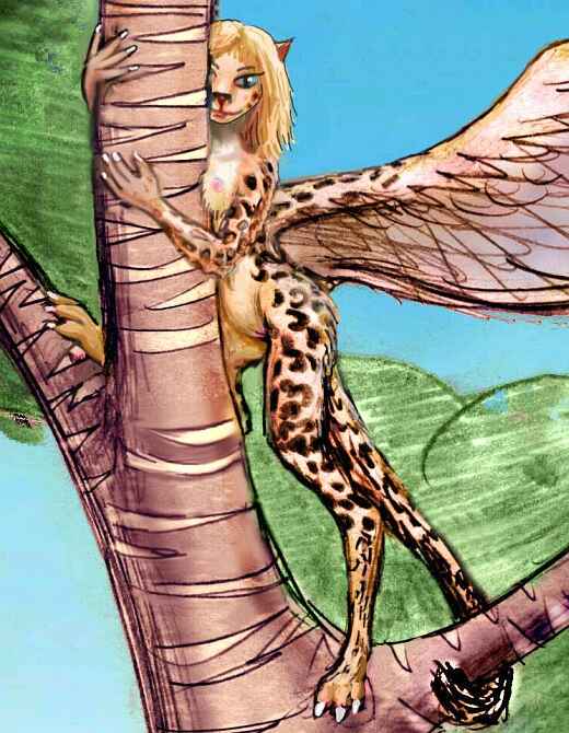
Between the many woven treetop villages of koreens, you find a village--well, a cluster--of much bigger rattan houses. At first you mistake the residents for a light, rangy, hot-weather subspecies of sphinx, but they're not. They're lebbirds, an unrelated arboreal species from the west. They're rare here for two reasons: while much of Diomedes is ideal habitat for them, it's already full of koreens; and the sea-passage is long and difficult.
Sphinxes and icari can tolerate cooler, drier, rockier regions, and fit in around koreens; tauraffes make their own environments, like elephants and humans on Earth; but lebbirds need rainforest. The sketch shows why: under that short, dappled, water-shedding pelt is a gracile body as heat-adapted as a spider monkey. And as your hosts tell you frankly, "we feel lost without our trees."
You cross the mouth of Guntra Bay and spend the day exploring Cape Dwarn, the northeast tip of Kilnu. Dwarn's a triangular peninsula 800 km on a side (500 mi) covered in lowland rainforest--it reminds you of Amazonia, an analogy you'll be repeating for the next few thousand kilometers!
At last ahead you see the turquoise gleam of the Drakho Sea, the heart of Diomedes--the only sea on Lyr that comes even close to being landlocked. Twice the size of the Mediterranean, and equatorial, it resembles a giant Caribbean. To the north is Lannach, to the west, Holmenach, to the south Kilnu. All Drakho's shores are rainforest. A jungle sea.
If we kept flying north over the coral reefs, two hours out we'd reach the Isle of Dwarn, a slender sliver of jungle 250 km long and only 50 wide (160 by 30 mi). Beyond is huge Krakna, fully 350 km (220 mi) across. But let's not wander off on dead-end flyways. You have a long-range choice to make, and it's best to sleep on it--if you can, in a squawky koreen village.
In the morning, you must decide either to:

WESTERN KILNU
(Most of you just flew in to Kilnu from Holmenach, over the Orikan Strait. A few, though, flew west from Cape Dwarn along the shore of Krakna Bay. Either way, we're heading south along the spine of Kilnu.)
Cape Krakna is the northern tip of Kilnu. This humid peninsula, 600 km long and 200 wide (400 mi by 130 mi) is rainforest from the mountaintops down to the beach. We could easily be in the South China Sea, except for the conical tauraffe barns looming ten meters tall, and the clusters of little koreen huts high in the trees. Classic two-story segregation of species by habitat. How ironic--this biologically driven gulf of a few yards is harder to cross than many real gulfs and straits thousands of km wide! Well... size matters too. Tauraffes twenty feet tall, koreens barely larger than a cat... And a related little matter: metabolic rate. Koreens just can't sit still waiting for tauraffes to finish their sentences!
Half a day down Krakna, the coast suddenly elbows west out of sight, and our flyway south heads inland up a river valley. We're crossing the base of Cape Tornak, a squarish peninsula 220 km wide. It too is rainforest from hilltops to waterline.
The hills slowly heighten ahead, snagging clouds, knotting into a great mass: Mt Tornak. Highest peak in northern Kilnu, it's 3700 m (12,100'). Forested almost to its ferny summit, here in the torrid zone Tornak is snow-streaked only now in deep orbital winter--not that you can see much. The cloud-knot is like a standing storm, lit salmon and gold now as sunset nears.
Lyr's swift dusk sweeps over the lower hills, but Tornak's vaporous entourage burns a lurid purple and red, lighting your way as you seek shelter for the night. A koreen village is all you can find, but by now you've learned to sleep through nearly anything... how can people so physically unlike parrots manage to chatter just like them?
The next morning, all morning, is spent just flanking Mt Tornak. More a range than a peak, it turns out--a whole line of volcanic cones 160 km long (100 mi). They've clearly been dormant lately, since the forest shows not a single break; but curving wooded ridges and steep little subsidiary cones suggest recent lava flows and cinder-eruptions--recent in geologic time, I mean! It's too high and cool for koreens, but icari like the area, and you still spot tauraffe barns under the trees, now and then.
In the afternoon, the land grows gentler, though still cloud-dotted and prone to showers. True rainforest! "And this is the dry season" you muttter after your fourth squall--and rainbow. A sunny hour in late afternoon gets pretty hot, but ahead is another standing storm, bigger and darker than Tornak. And much higher. By evening you're a mile up, skirting Mt Kilnu, tallest peak on the island, at 4400 m (14,400')--so high that even here, just six degrees below the equator, it bears a heavy snowcap. You can see it easily; unlike Tornak, Kilnu's main peak floats above the clouds. Like an ice cream cone wearing a turbulent gauze tutu...
You climb part way up the southeast face to an icarus eyrie, on a small lake--a lava-dammed valley, you're told. The eyrie burrows right into an old lava wall, taking advantage of spots where the outer skin hardened but the still-liquid inner layers subsided, leaving caves. It's been much expanded, but where they could, the villagers kept the arched lava-tube ceilings, knobby and stringy and ribbed as if we're inside a dragon's gut. They like the effect. You find it creepy. A species difference? Don't jump to conclusions! Maybe you'd love it too, if you'd grown up here. Hard to say. But that night you dream you're swallowed by whale-sized icari, over and over.
In the morning, you wheel round the mountain to its south face, the source of the Srygen River. It's the longest in southern Kilnu, and a good guide for the next phase of our journey. You glide easily down its broad valley all day, some 500 km (300 mi).
Toward dusk, the south-flowing Srygen bends abruptly west, heading for the sea. The reason's obvious. There's a slight obstruction: volcanic Mt Srygen, two miles high! Its grassy western slopes are in a rainshadow--the first subalpine break you've seen in the rainforest covering northern Kilnu. You're leaving the equatorial rainbelt at last.
In a grove at the mountain's foot, you spot what seems like a triple-sized koreen village. Not! It's a colony of lebbirds. They're rare on the Diomedean mainlands--you met a few families up north in Holmenach, living in villages of icari, pegasi, sphinxes, and koreens, but this is your first lebbird-majority village. It's understandable: few lebbirds risk the long, dangerous passage over the Rijn Sea from Wersgorix, their homeland.
How few? Curious, you ask around, and find only a couple of residents here from Wersgorix, one just two years back, one over a decade ago, in her wild youth (no, lebbirds aren't short-lived; 10-12 Lyran years is 25-30 by our calendar). Only a handful more are second generation; most are third or fourth.
So lebbirds are a naturalized minority here, not a wave of immigrants. The Kyrie Islands flyway is just too difficult, and lebbirds' ideal habitat here (warm rainforest) is already full of native koreens. From the Kyries, which they did settle successfully (as the coast-hugging koreens had never discovered it) the nearest mainland was southern Kilnu, which does have a scattering of lebbird villages now. But only a few lebbirds have ventured north into Holmenach yet.
These lebbirds, living in more open woods with a few meadows, practice pastoralism as well as their usual silviculture. They herd milk-monkeys. These beasts look more like chocolate-colored goats to you, if goats had stubby wings and long, tubular snouts and perpetually puzzled eyes (unlike goats, whose eyes have seen everything), but still... goats. Yet "milk-monkey" is how the name translates. You try monkey cheese, which isn't bad, but decide not to ask exactly how they milk the monkey. Just so you don't have to do it...
If Kilnu looks like a ragged leaf, Cape Trekkan is its long stem--a rugged finger 1600 km long and only 1-200 km wide (1000 by 60-125 mi). Trekkan's east slope is solid rainforest, with numerous lebbirds among the koreens and tauraffes; but on the west, the woods open up and occasional glades and meadows afford views. And herding opportunities for lebbirds; they're no longer rare, here in the far south.
Southeast of Cape Trekkan's tip lies Angrek--a rugged land 550 km (340 mi) long, with many satellite islands to the west in the shallow little Angrek Sea. It feels quite Mediterranean, with open woods and meadows. Instead of exploring the wetter eastern end, we'll wander southwest along its almost Grecian peninsulas and isles to the southern end of the Angrek Sea. Antel are common here, lebbirds rarer, except in the greener hills. There are even a couple of villages of immigrant cheetaurs from Cape Rodonis, 6000 km to the north--the children of a single boat-full of cheetaurs, still setting down roots (literally; their orchards are still immature).
Here you must decide:
From Kilnu, the Ro Islands lead south for a couple of days--around a thousand kilometers--not that that should faze you by now! On the third day they crook sharply east. It's another thousand km to Ro proper.
You spy Ro near sunset on the fourth day--low red hills lit full-on by the dying sun. You spiral down to a village on the shore--not an icarus eyrie or treetop lebbird village (no crags to hollow out, few trees to build in). On Earth this would be normal, but by now, you've been on Lyr long enough for it to seem odd. Who builds on the ground?
Cheetaurs, of course. Where else could they, with no wings? It's an experimental settlement, like the one some of you more dedicated readers have seen in northern Diomedes, on the coast of Dawrnach. But there's a difference: this one's an intentional colony, not the result of a shipwreck. The cheetaurs welcome you (someone new! someone sexy! Cheetaurs like novelty) and proudly show you their little utopia as the sunset turns wonderfully lurid above you, over the western sea... Drumming and dancing follows, and, if you're broad-minded enough (and not afraid of those claws) romance down on the beach, under the red and silver moon.
The next day you head inland. There's a lot of inland. Ro is by far the largest of the chain--a wasp-waisted island 700 km (450 mi) long. All the Ros are fairly dry, mostly Mediterranean in climate, but here in the west, downwind from the central hills, it's a true desert except right along the shore. The cheetaurs tell you they do have icarus neighbors along the coast, but the inland plains are home only to antel, drought-tolerant deerlike natives of the Gaiila Cluster, who settled here long ago.
By noon you're over the central hills, a much greener zone, with "oak" groves on the western slopes and pinelike forests to the east. As you descend again to the eastern tip, groves and riverine wooded strips dot and stripe the coastal plains; it's clearly rainier here. Quite Californian! You sleep in a mixed sphinx/icarus fishing village on a bluff at a rivermouth.
Ro's the climax of the chain. Taking the locals' advice, you dawdle the next morning, and set out to sea only around noon. You islet-hop for a couple of hours, but before sunset, the islets end. You sleep early and rise early, for today you face a nine-hour flight, over 500 mi, out of the Ro Islands to the westernmost atoll of the Borans...
At dusk, you spot a little coral islet, and set down exhausted. No fresh water, but at least you can sleep.
And the next day more islets are visible to the east, set in wide turquoise shallows dappling the azure deep. You find fresh water before noon.
Well before sunset you've reached Boran itself, a respectable island 180 km across, with a dark hump of forest on its central hills, sending out crooked green spiderlegs: tree-lined, drinkable, year-round creeks. Ahead, the long whaleback of Mangivolo looms on the eastern horizon. You've come full circle round the huge Diomedes cluster.
The next day, on Mangivolo, you meet a flock of icari, creatures like cat-furred angels, who are heading south to the Rorvan Archipelago and the Ak'hai'i Region beyond. A few are even going on to visit the experimental gryphon settlements in remote Averorn, southernmost of all habitable lands.
I warn you the southern flyway isn't easy--it's an 1800-km flight to Ak'hai'i with not a rock to rest on! But the icari have lovely tortoise-shell fur, and are famed for their sensuality, and seem very friendly--so you're tempted. It's up to you.

TOUR LYR! The following route snakes around Lyr, covering all major features:
Ythri -- Polesotechnic Chain -- Troisleons -- Roland -- Oronesia -- Gaiila -- Flandry -- Diomedes -- Ak'hai'i -- Averorn
World Dream Bank homepage - Art gallery - New stuff - Introductory sampler, best dreams, best art - On dreamwork - Books
Indexes: Subject - Author - Date - Names - Places - Art media/styles
Titles: A - B - C - D - E - F - G - H - IJ - KL - M - NO - PQ - R - Sa-Sk - Sl-Sz - T - UV - WXYZ
Email: wdreamb@yahoo.com - Catalog of art, books, CDs - Behind the Curtain: FAQs, bio, site map - Kindred sites