
PEGASIA:
Geography and Climate
by Chris Wayan, 2006-9
Pegasia's homepage - Map - Geography & climate - Evolution - Critters - Gazetteer - Sketches - More worlds? Planetocopia!
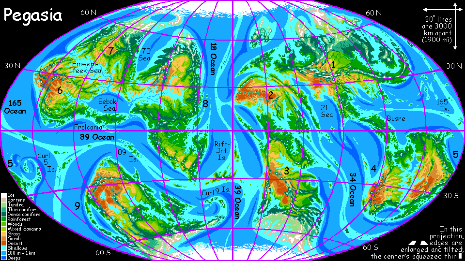
Looking at this map, do you feel deja vu? At first glance, Pegasia resembles ancient Earth, with inland seas and flooded continental shelves. But the geography echoes modern Earth--Old World on the right, New World on the left, S-shaped Atlantic dividing them... even ehoes of Africa, Asia, Europe, Australia. Though Pegasia's more crowded--continental platforms rubbing each other's shoulders! Nine continents plus many Greenland-sized islands...
Part of the similarity is just cartographic convenience. Pegasia is a mere moon orbiting a warm Jupiter, remember? One side faces perpetually inward--Zeus hovers in the sky, day and night. Well, in my first version of the map, I put the prime meridian (vertical centerline) in the middle of the inner face, where Zeus floats at zenith... but that cut up and distorted several continents. Since most of my readers are land animals, I wanted the continents center stage, so I redid the map this way. On the left, the inner hemisphere, always under Zeus. On the right, the outer hemisphere, where folks will think they're on a planet, until they evolve a Magellan and discover the big red eye of God glaring down on the back side of the world. Now let's reconsider those echoes of Earth's layout--like the Atlantic down the middle. It's unavoidable! Pegasia, at this moment in deep time, has a sinuous mid-sea rift nearly ringing the world pole to pole. No matter which limb of it you put out at the edge, the other will run down the middle... et voila! Instant Atlantic! It's just a result of my being a land animal who likes my continents unchopped.
SEA LEVELS
35% of Pegasia's surface is land. Sounds similar to Earth (29% land). But the numbers are deceptive. Earth's continental shelves are 5% of its surface, making the continental platforms about 35% and sea-basins 65%. Sounds even more comparable, yes? But nearly a quarter of Pegasia is continental shelf and shallow inland seas! The continental platforms are fully 57% of the surface; sea-basins are only 43%.
To see the implications, we have to see through another illusion created by cartographic convention. Really, you can't see sea-depths from the air, not after the first couple of hundred meters. Water color depends more on dirt than depth! But while cartographers use diverse color- and shading-schemes on land, they always portray ocean depth using colors from dark to light blue, because humans automatically read it as depth (culture or instinct? You tell me.) But this only tells you relative depth. You have to read the legend to realize how shallow Pegasia's seas are--less than a fourth the water in our seas! True, Pegasia's surface is a bit smaller; measured per square kilometer, there's almost a third of Earth's water. Still, Pegasia's a drier world than it looks!
Inevitably, the lower sea levels let erosion shape the lighter continental rock into wider, lower platforms... These wide shallows have three major consequences:
The present high seas make Pegasia's coastline look insanely fractal. Mr. Slartibartfast has been working overtime on his fjords again! Only here the sculpting tool's not ice but rising seas, and the model's not Scandinavia but Chesapeake Bay. Most of the gulfs and inland seas still have winding channels down their middles: drowned river-canyons.
Pegasia's seas are mostly the same width, with rifts roughly down the middle--far more regular than Earth's. That suggests they all started spreading about the same time, perhaps 200 million years ago. What happened? Did something hit Pegasia hard enough to wake it up tectonically? There's some evidence this may have happened half a billion years ago to Venus.
Mid-sea rifts on Earth rarely surface--our seas are just too deep. Not on Pegasia! Islands rise along the rifts, in places--up to the size of Japan. There are some very strange lakes on these islands--warm, bubbling mineral soup stained lime-green, slime-green, gold, or screaming magenta by halophilic and/or thermophilic bacteria. These are the surface equivalents of Earth's mid-sea vent communities, and they may well be where life evolved on Pegasia.
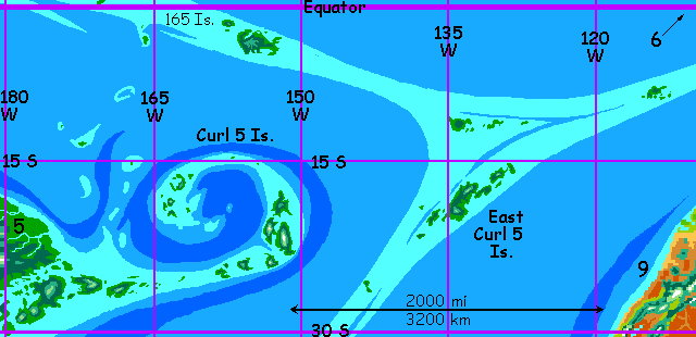
Near the two places where the planetary rift system forks, there are structures like hooks--almost spirals. The rift zones here don't just push but scrunch and crumple the sea bed here. We have analogs on Earth: the Seychelles and Mauritius, in the Indian Ocean. The sinuous sea-ridges around Sicily are a less obvious but similar case, squeezed by the closing of the Tethys Sea. But every continent on Pegasia shows signs of this squeezing, for unlike Earth's spacious plates, these continents are crowded--unable to drift, they suffer continental scrunch. Most coasts have subduction trenches offshore and high coastal mountains--Cascades and Andes.
All those extra coastal ranges can block storms from reaching the interior, though the many inland seas often prevent deserts--by eliminating inlands altogether! Still, Pegasian climate is a patchwork with sharp, mountainous boundaries--echoing the jagged, fractal feel of the coastline.
GLOBAL CLIMATE
Pegasia has six poles, not two: north, south, inner (facing Zeus), outer (facing away), front (the leading face) and back (the trailing face). North and south are cold, though not as cold as Earth's. The inner pole has hot days broken by a long noon eclipse, and warm nights, with Zeus looming overhead like a bed of coals. The outer pole is hot but more continental, with noons unshaded by Zeus and nights unheated. The front pole has warm days and nights crackling with auroras nearly to the tropics; the back pole is warm and mild.
The left side of the map is the inner hemisphere, facing Zeus; the right half's never seen the big planet. The center of the map is the peaceful trailing edge; the outer edges are the leading face as Pegasia orbits--more meteor strikes, auroras down to thirty degrees! Rotation is to the east, as on Earth. That's just a convention, of course--it's how I decided which pole to call north in the first place.
What drives glaciation, and why is Pegasia warm right now? The pole-to-pole rift is the cause. It's pushed previously polar continents out of the cold zone. Thin sea ice still covers the poles, as in our Arctic, but Pegasia lacks any analogue of our Antarctica now. Two north poles, so to speak! Even when CO2 levels fall, glaciation is limited to polar islands. At least for the moment! Several subpolar peninsulas have all the signs of old glaciation. In deep time, the ice will return--and melt, and return.
Here's a quick and dirty sketch of Ice Age Pegasia--not too realistic because it's been not thousands but millions of years since the last glaciation, and the continents were in different positions. In fact that's what causes Pegasia's irregular ice ages.
But being lazy, and having just a rainy morning, I iced over a current map of Pegasia to create a truly recent ice age, as if modern Pegasia were in a mere Terran-style interglacial, rather than be authentic and shift Pegasia's continents back in deep time. Though that would be a splendid exercise! I hand it to you, Dear Reader--a tectonic exercise handed you on a (snicker) plate...
But still, the map below gives you a good idea what happens to continental interiors in ice ages. Perhaps it's a virtue that it devastates a relatively familiar landscape you can compare directly to a warm-era map, rather than present an utterly alien geography. Even so, it's almost unrecognizable--Inneria, the supercontinent dominating the Inner Hemisphere (left) fuses Continents 6, 7 and 8; Continent 9 is, as always, a loner; Continent 1 through Continent 5 all fuse into the righthand supercontinent, Outeria.
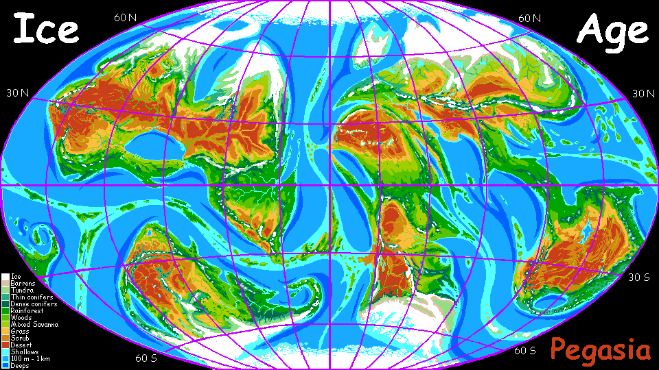
And, please note, this isn't fanciful; it's heavily based on what happened here. Earth during the Ice Age did have its Edens--the New World before humans arrived had areas richer in megafauna than anything today. But overall, on Earth too biomass almost certainly shrank during ice ages. Forests died back worldwide; much of Earth was either frozen or dustbowls.
Cold and dry go together like hot and wet. We only say "the Ice Age" because the scientists to name it came from the two subpolar lands where the largest ice sheets centered. Had southern or tropical scientists weighed in first, it'd probably be called "the Dry Age." When the weather cools and icecaps grow, the sea recedes and rains fail.
On Pegasia, the drying effect is a little more visible, that's all. Why? well...
DORMANT DESERTS
Pegasia's slow rotation makes winds generally gentler than Earth's, though of course there are local exceptions. But worldwide, one ecological consequence is that storms travel leisurely and don't penetrate as far inland. This is mitigated a lot by Pegasia's dense air, which transports more moisture overall. But marine and coastal climate does fade into harsher continental climate (with more steppes and deserts) sooner--perhaps two-thirds of the distance on Earth at a similar latitude (and Pegasia's smaller size masks even this quite a bit). This "storm fatigue" isn't much of a problem on modern Pegasia, with its many inland seas. But when the poles have large icecaps and the sea drops, watch out!
Only in the time of Pangaea, when essentially all Earth's land fused into a single monstrous mass, have we seen inland deserts as extensive as those on ice-age Pegasia. And Earth's harsh Pangean climate (deserts and extreme monsoons) didn't require an ice age at all; just a shortage of coastline and a huge interior!
I keep saying, on these pages, "Life loves a borderzone." But that's a little deceptive, implying it's all about access to more diverse niches, a varied landscape. But even ignoring diversity, maritime climates are consistently friendlier than continental ones. And the sheer size of Pegasia's continental platforms makes the land prone to fusing into supercontinents--with dead hearts.
The gazetteer will have a full index of native placenames, with descriptions--once the contests's over and we have natives to name them.
World Dream Bank homepage - Art gallery - New stuff - Introductory sampler, best dreams, best art - On dreamwork - Books
Indexes: Subject - Author - Date - Names - Places - Art media/styles
Titles: A - B - C - D - E - F - G - H - IJ - KL - M - NO - PQ - R - Sa-Sk - Sl-Sz - T - UV - WXYZ
Email: wdreamb@yahoo.com - Catalog of art, books, CDs - Behind the Curtain: FAQs, bio, site map - Kindred sites