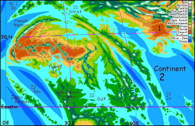
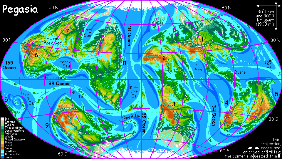
CONTINENT 2
by Chris Wayan, 2006-2010
Pegasia's homepage - Map - Geography & climate - Evolution - Critters - Gazetteer - Sketches - More worlds? Planetocopia!
First-time orientation--strongly advised! Pegasia is weird.
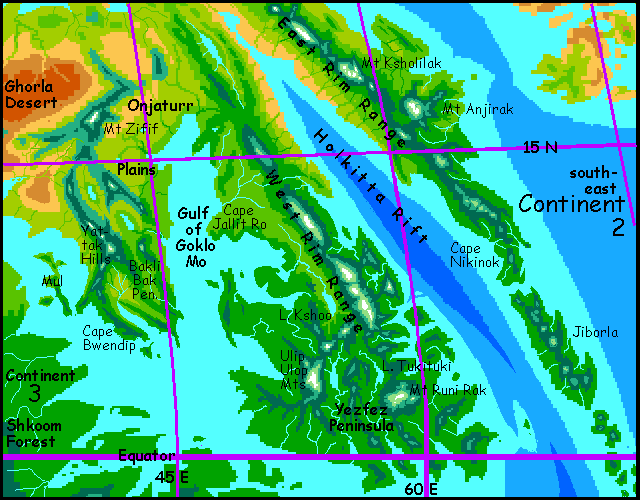
Overview - Names - Fractality - Eastern Isles - Great Rift - Southeast - South - West - North - Full Circle?
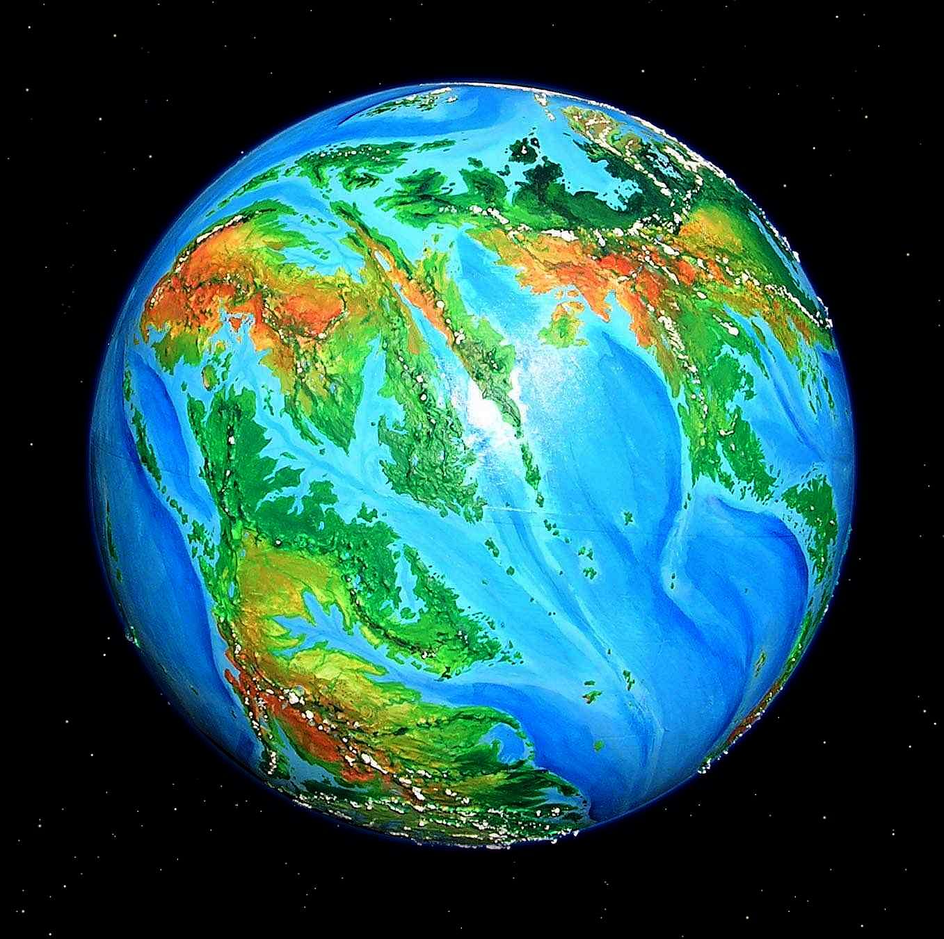
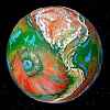
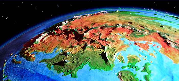
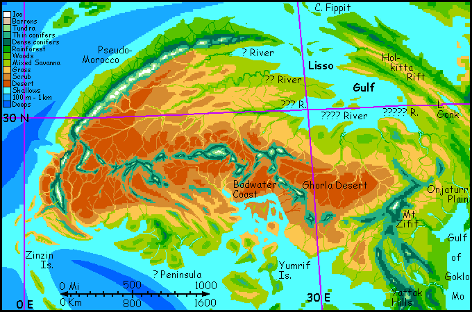
Continent 2, in the high orbital photo below, is the broad, mostly orange landmass in the upper left. Below it is Continent 3; to the right stretches Continent 1. On the horizon at lower right is Continent 4. Together with Continent 5, just over the right-hand horizon, these continents form a chain with over half the world's land; the continents of the other hemisphere aren't just smaller but more isolated. Thus, civilization may progress faster here in the so-called Outer Hemisphere; and Continent 2 is in the heart of the chain.
Continent 2 could almost be named Saharia: it's the driest continent on Pegasia, and it's even shaped like the Sahara plus Arabia and Ethiopia; subsaharan Africa's cut off by shallow seas. Still, Continent 2's broad western desert is not Saharan, really--it's broken up by warm gulfs and high mountains, full of river canyons and artesian basins. And the east is far greener than Arabia or the Red Sea basin or Ethiopia--quite jungly, in fact.
Geologically, east and west Continent 2 are as different as their climates. The west is part of the Continent 3's great platform to the south; the rugged east is a huge rift zone structure (hence its resemblance to the Red Sea).
Overview - Names - Fractality - Eastern Isles - Great Rift - Southeast - South - West - North - Full Circle?
Continent 2 (and Continent 3) are the site of an experiment. On Pegasia, I've held off on naming features, leaving you readers to send me proposed placenames in the languages of your proposed natives. A good if extreme example of the result is southern Continent 6, home of the frolcons. But submissions have been slow and hesitant; and emails from some world-builders have suggested that many readers who want to create their own people feel intimidated by this extra task. It is hard to create a convincing language (and good names)--just as hard as the hard-science knowledge needed to invent a good alien and the artistic skills (verbal and visual) to depict it.
So here and on Continent 3, I'll try out a new model--I'll name Continent 2's features and introduce more detail about what I see, making it as real and detailed as I can without limiting the appearance or biology of potential natives. My placenames will come from hypothetical languages with clear, standardized spelling and pronunciation guidelines. And I'll group these placenames by hypothetical language on a hidden page for species designers, in the hope one of these tongues will seem plausible for a species you have in mind.
Or maybe the names will evoke a species for you. Sympathetic magic, really, akin to the cave artists of Lascaux and Altamira. But then isn't that what all fiction does? Summon people out of words? It's still up to you the reader to picture these people... and to actually send me the pictures! C'mon, don't be shy...
Overview - Names - Fractality - Eastern Isles - Great Rift - Southeast - South - West - North - Full Circle?
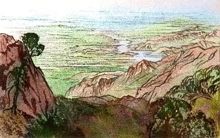
All Pegasia looks fractal compared to chunky Earth, since there's little polar ice and lowlands are flooded. But Continent 2 is extra-fractured. The east is a rift zone as rugged as East Africa and the Red Sea. It's hard to tour in a linear fashion--all jagged peninsulas! But I'll give it my best shot, starting on the southeastern capes, zigzagging generally west along the southern shore (over and around the bays and mountains in the way) then north along the dry west coast, east over the great prairies, and north along the rift zone again. That means we start in the middle of nowhere. I don't mean a wasteland. No land at all. I really, really hope you already read the survival tips.
Oh well, too late now.
Overview - Names - Fractality - The Eastern Isles - Great Rift - Southeast - South - West - North - Full Circle?
You're flying over a tropical sea. I hope you adjusted your wing-straps properly; you can't land and and fix them now. The only land in sight is one green hump hours behind us, half-hidden by clouds on the southeast horizon, and another hump hours ahead. If it's any consolation, even the locals (far better fliers than us) rarely use this flyway; it stretches thousands of km to Continent 3 and southern Continent 1, but none of the routes are easy. Geologically, it's a mid-sea ridge (much like Earth's); but Pegasia's seas are so shallow the ridge's high points form frequent islands (rare on Earth). This is a relatively easy stretch, not a lonely deep-sea passage; land's in sight, and so are half a dozen gaggles and lines and Vs of distant fliers. If you crash like Icarus, there's even a faint hope they'd fish you out before you drown; as safe as sea-travel gets, on Pegasia! Just the baby pool.
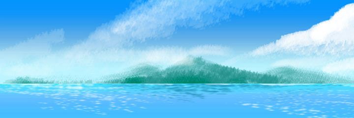
By noon (in the long, long Pegasian day--nearly 13 hours since dawn) you've flown several hundred km along this tropical chain, stopping every other island to rest and and taste the aromatic fruits of the rainforest canopy. The local silviculturalists won't begrudge you; they planted them for travelers. Who are these tree-farmers? You tell me. I only know they're light and agile enough to live up in the sunny canopy; a ground-dwelling population of any density seems unlikely--too dark and close down there.
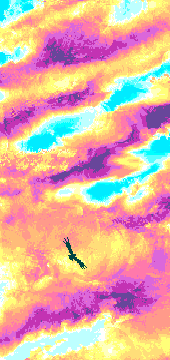
You sleep through the noon heat before flying on to the next island, Jiborla. Rounding the flanks of each volcano, you expect to see the sea again, but Jiborla's huge, fully 750 km long (460 mi)--a Java, not a Bali. Near sundown you're starting to suspect I lied twice and this really is the mainland, but a moat of fire appears ahead: one last channel mirroring the slow sunset. Over the strait, the colors turn wild and the horizon disappears--you're flying through a psychedelic dream of magenta tigerstripes above and below. You're too tired to appreciate it fully, though. A long day! And I do mean long--26 hours of daylight. You skid on the beach, strip off your wings, and curl up in the dune-grass of Cape Nikinok... on Continent 2.
You sleep 15 hours--more than half the night! A stretching session, a moonlit predawn swim (what moon? Not huge Zeus, the gas giant Pegasia orbits--we're on the outer face of Pegasia, where it's never seen. That big rusty moon in the sky is Tharn, one of Pegasia's sister moons. It's bigger than Mars--big enough to have intelligent life of its own!) A solid meal, a second sleep, and when you wake at dawn you feel ready to appreciate the scenery. It's worth a look; dawn here's as wild as the sunset. Damp tropical air nearly twice as dense as Earth's to filter the rising sun's light, and puffy clouds as screens for a fiery display lasting all through breakfast and beyond. A slow day has its own rewards.
Today you practice riding the winds along the mountain-spine of Cape Nikinok. Hours of gliding, just bending your wingtips; spiraling in upwinds, then darting across shady valleys to regain height on the next ridge.
Overview - Names - Fractality - Eastern Isles - The Great Rift - Southeast - South - West - North - Full Circle?
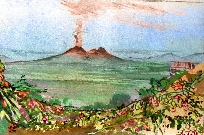
The hills below are seamless emerald, with trees 70-100 m tall (Pegasia's low gravity encourages skyscraper trees). Rains on Nikinok are year-round, though heaviest in orbital summer. But slowly, over the endless day, the rainforest opens up. By afternoon, we're creeping north into a Mediterranean strip. At last, a monstrous volcano looms ahead, ice-flanked: Mt. Anjirak. The signpost at last! Time to turn inland--west. It's a real climb, for the wind's unhelpful here. Chug up slowly, over brushy slopes, then woods.
In the morning, not far north, another icecapped massif looms, this one many-headed: Mt Ksholilak's half-dozen cones. One lava- or mud-flow forms a blunt cape narrowing the rift. Fly out this point to the tip. From here, the West Rim's quite clear now; the gulf's narrowed enough to cross with ease in an hour or less: 65 km (40 mi).
The western shore is Mediterranean too, at first. I won't lead you further north yet; most of Continent 2 lies to the west, and the most fertile region, the Yezfez Peninsula, is south of us. I promise we'll see the north in the end, but for now, bank left, back down the west shore of the Rift. By sunset you've passed five more volcanoes high enough to bear great icecaps, with dozens of pups the size of Vesuvius around their knees. Smoke and steam rise from one...
Offshore, the East Rim fades into the distance as the gulf widens...
Overview - Names - Fractality - Eastern Isles - The Great Rift - Southeast - South - West - North - Full Circle?
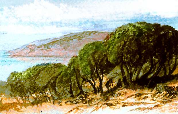
Relax and take a few long Pegasian days wandering around the Yezfez Peninsula, which has half the biomass of Continent 2. It's a maze of tropical sounds winding between lush hills below scattered snowy volcanoes. Since you're just 5-10 degrees from the equator now, that snow tells you those peaks reach 5-6 km high (16-20,000'). Of course, it's easier for mountains to reach that height on Pegasia; tectonic pressures are high and the gravity is low.
But no need to go mountain climbing. You deserve a break. Loaf around in the coastal lowlands, staying in the treetop garden-villages of the heat-tolerant, nut-cracking, fructivorous Weksheks--at least I think that's their name. Their chattering language can be heard all over the equatorial zone, from here to the Zinzin Islands 6000 km to the west, and south deep into Shkoom Forest on Continent 3. What do they look like? Parrots, winged monkeys, gliding lizards? You tell me.
You should certainly get in some swimming, too--the reefs here are famous. Are they inhabited by an amphibian fishing race that trades with the treetop people? If so, who? Clever-toed newts, toughened-up squid, tool-using otters, tree-climbing crabs? You tell...
As you drift lazily south, the West Rim grows ragged; several parallel ranges and scarps now. Bays break in. At last, at the foot of a final glacier-topped peak, Mt Runi Rak, you bank right and head inland away from the Rift. Over a cloud-forest ridge, there's a long lake in a misty valley: Lake Tukituki. Dark green ridges to the white wall of the horizon; at first you assume it's all cloud, but now and then they part to reveal ice and red rock: another great range, the Ulip Ulop. They're a formidable barrier blocking our way west, and to tell you the truth, the western lowlands of Yezfez Peninsula are much like the east--wekshek orchards and villages, coral-reef sounds. So our route veers northwest, between two lesser though still snowy cones. A long slow haul; no help from the winds, for the great peaks around the valley shelter it.
From the pass, you see a second larger lake, Lake Kshoo, below the snowcones of the West Rim Range. Volcanoes all around, in fact. The only way out of the Kshoo Basin is to the north, down a long narrow river valley. Follow the Kshoo River down to the mouth, then further northwest, across the base of Cape Jallit Ro. For the first time in days you see clearings; the forest canopy is opening up, for Jallit Ro is monsoon country, getting equatorial storms only in the summer months.
It still takes a full Pegasian day to fly round the head of the Gulf of Goklo Mo and leave the Yezfez Peninsula.
You find yourself above a great plain. Well, rolling hills, but nothing after the ice-giants along Yezfez's spine. Great bald patches of yellow grass open up; trees line only the watercourses. The rains are failing. We're nearing the end of the lush southeast. This is Onjaturr Plain, the first finger of the great savanna plains of the west. No wekshek villages here. Big herds of something. Zebra stripes? It's hard to tell, they raise dust. Are they wild or domestic herds? Or a crowd of graminivorous people? From this height I can't tell. But you might.
A final great icecapped peak floats on the western horizon: Mount Zifif. Its shoulders are dark forest, but its lower flanks are scruffy brown. So are the nearer hills.
And yet, and yet... as we fly south along this west shore of the Gulf of Goklo Mo, the woods return--opener monsoon forest, not as tall as the rainforest behind us, but still grand country, with small lakes gleaming like eyes, fed by streams from the dark evergreen mountains to the west. This is Bakli Bak, and that syllabic repetition tells you that although it's dry country for weksheks, there are still treetop villages here, new and raw. It's their Wild West! Settlement here only dates back a thousand years. No really, that's new--Pegasian years are just seven Earth months, and weksheks count in base... wait, am I constraining all you species-designers too much? Well, let's just say that when Darwin first published On the Origin of Species, these villages were still being woven. Besides, whether weksheks count in base five, six or seven, that doesn't specify five six or seven what. Digits, limbs, eyes, nipples? Just build some weksheks, all right?
On the third day, Bakli Bak abruptly ends--to the south is just shallow sea. Wheeling right, you follow this south coast to the west. That night you sleep in a wekshek treetop village a mere 10 meters up (33'). By now you know how bizarre it is to be almost within reach of the ground. Almost? There are circles of what look like pumpkin-vines down there. These weksheks are experimenting with agriculture! Wow, digging in the dirt instead of fruitpicking in the treetops--this truly is the wekshek frontier.
The next day, what seems a long island in the southern gulf slowly grows nearer until, hours later, it joins the mainland. It's called Cape Bwendip, and its maritime climate sustains tall graceful woods--a tree-oasis! Carefully tended, it's one huge wekshek orchard. Bwendip's villages are wealthier but (as a direct result) more traditional. Not Manhattan--more Staten Island. Let's cross Bwendip's low hills to its southern coast, exposed to the 32 Gulf. We need to stick to the shore. You'll see why in the morning...
Next day, a steep wooded range runs north out of sight: the Yattak Hills. Before you it juts into the southern sea, forming rugged, narrow Cape Mul-Yattak. Over a narrow strait, a long island continues the ridge south: the Isle of Mul. It's the easiest flyway to huge, rich Continent 3--but patience! We have business west.
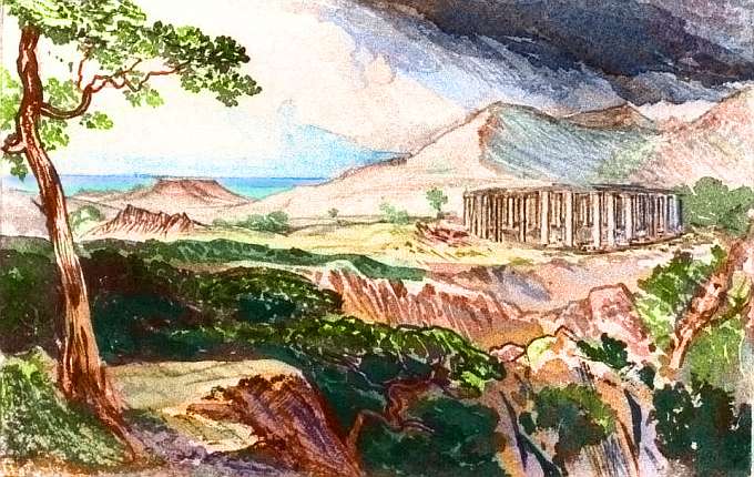
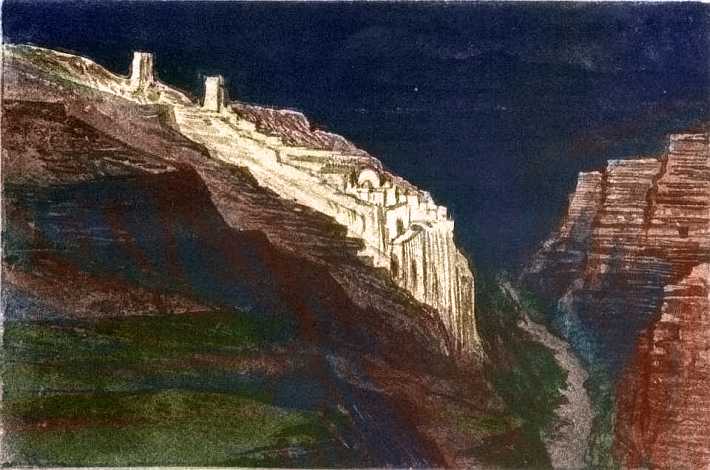
You start climbing Yattak Ridge. Just scattered trees now. A temple. Well, the ruins of one. Huge stone columns, fluted and capped--quite Greek, except they're set in concentric rings, the largest a good sixty meters across (200'). A stupendous labor! Pegasia's Stonehenge.
Who built it? Certainly not weksheks! Quarrying under(shudder)ground is not their thing. Still, can't hurt to ask...
At last you resume your climb... For such modest hills it's tedious: the wind's in your face, down the slope. No wind-riding today! Your shoulders are getting sore. Now you see why we've been hugging the south coast: inland, where the Yattak Hills grow higher, the climb gets grueling. Temple Pass is only 500 meters (1600'). Only? In that downdraft, it feels like six times that.
But at last the slopes and gullies flatten. The pass! Ahead, patchy green and gold savanna stretch to the horizon. The West! Geographically you're still well east of Continent 2's heart, but you know instantly Temple Pass is the border. The prairie below is another world.
Overview - Names - Fractality - Eastern Isles - The Great Rift - Southeast - South - West - North - Full Circle?
For two days you fly west; well, north of west now, for the coast angles slowly away from the equator--and its rains. The land fades from golden hills to tufted grasslands to brown scrub. Great herds of... animals? Or are those grazers people? Why not? We can't get a closer look, because they're skittish, and not designed yet. Let's leave them in Heisenbergian uncertainty for the time being, just noting that eventually a visit to a riverside village (if they HAVE villages, and aren't completely nomadic) will eventually go here...

The first day out isn't too bad, for streams descend from the Yattak Hills. But the next few days are thirsty flying. Here a salt gulf cuts deep into the western desert, nearly to the mountains' feet. The shores are dry red hills; coral reefs fill the winding sounds between a flotilla of rocky islands, from mere sea-stacks and arches to several bigger than Crete. From the map, you know the Yumrif Islands grow steadily greener to the south: a second bridge to Continent 3. Longer and harder than Mul! Let's keep on.
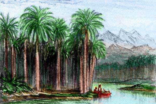
You cut west over a couple of desert sounds; one finger winds northwest out of sight, though you see a line of snowy teeth on the northern horizon; the sea can't go far. The reefs look inviting, but it's fresh water you need, and that's very scarce. 100 km or more of red rocky capes and canyons with no more than scummy pools, before you find a creek that makes it to the sea from those inland mountains. And then another hundred. And another. They call it Badwater Gulf for a reason. Even with wings, it's a hard passage. You shudder to think of crossing this barren, searing washboard on foot!
A day to the west, the coast bends south. Streams, just trickles but clean and drinkable, reach the sea, fed by inland hills. You're verging on a great hilly peninsula with sparse open woods. A bit further south and more maritime than the Ghorla Desert, it's in the path of more tropical storms.
I passed one of their clifftop villages once--a walled, gateless fliers' town perched on a crag like an eagle, offering no concessions for the wingless. Or amateurs like us.
What do they look like? You tell me. All I'm sure of is this--they'll be rangy and big-eared for heat dispersal, and their religion will be designed to placate a thunder-god. Not a remote growler off in the sky, as in human religions, but a fierce, unpredictable peer, a flier like yourself, but prone to bizarre tricks. Death here is no medieval Grim Reaper, or a classical Blind Archer, but a keen-eyed Mad Sniper.
Overview - Names - Fractality - Eastern Isles - The Great Rift - Southeast - South - West - North - Full Circle?
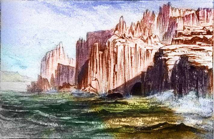
And then, after days, the coast bends sharply north. This western cape is your last chance to turn off and skip the desert! If you'd prefer a tropical beach vacation to a Saharan safari, just bank left. 40 km (25 mi) offshore is the first of the Zinzin Islands, an Indonesian island-arc nearly 4000 km long, leading to the west coast of Continent 3. These northern Zinzins are long, low, narrow ridges, often cliffwalled, rising from the sea. Dramatic, but beware; water's scarce here. But as you island-hop southeast, an hour or two per channel, you're heading into the equatorial rainbelt. Half a dozen isles out, you hit the jackpot: Zinzor, a miniature Madagascar 500 km long with a halo of lesser isles around it, all mountainous, green and wooded. There's still a long dry season, but with those heights trapping rain, you'll have no trouble finding creeks from now on.
In the next few days you sail down Zinzin itself, bigger than Java, following a line of smoking volcanic cones above lush jungle. After Jompri, the chain grows drier and patchier again; meadows open in the woods of Konki, Janko and Jinkatto as you near the almost Mediterranean shore of Continent 3. It's a varied and scenic trip, and I nearly built a separate page for it; but I couldn't decide which way to lead you through the chain. And the Zinzins are only a minor flyway and thus rather rustic; few Pegasians are crazy enough to want to visit Continent 2's deserts! So, to those of you sticking with me, as we bank right and follow the coast not the Zinzins: I admire your courage and trust, if not your judgment.
You're heading north along a Saharan shore getting almost no rain at all--dry hot winds blow off the jagged mountains, not from the sullen sea. Red desert coast, though the higher peaks inland are tall enough to wring sparse rain from thunderheads; their middle slopes are dry scrub and grass, and their shoulders scruffy evergreen woods, though even the heights are gray and sparse as a balding old man. Still, they send trickles down the deep canyons on their flanks, even if they don't always reach the sea. We won't die of thirst, probably; just keep your eyes open and ask the locals. If any. Well, maybe you shouldn't rely on their advice. The smart ones all took the Zinzin Flyway out of here. Cultural dregs. And they're used to all the parasites in the stagnant river-pools. Ugh.
These fists of jagged rock make this coast a deathtrap for mariners... and the wingless. Good thing you're a temporary bird! The ruggedness actually helps: all these cliffs generate updrafts.
So who lives here, in this ecological island as big as Italy? You tell me.
For days we fly east along Pseudo-Morocco. Perhaps we stay at inns; it's up to you. Certainly land this fertile's not empty!
At last, the mountains bow their heads and march down to the sea. You wheel right, over the last-gasp hills, and enter another world...
Overview - Names - Fractality - Eastern Isles - The Great Rift - Southeast - South - West - North - Full Circle?
Ahead of you lie low, rolling hills of savanna to a level, hazy horizon--the prairie heartland of Continent 2, around Lisso Gulf. Most streams here are small and seasonal; but now and then we'll pass a larger river from the inland mountains. These are snowfed and perennial; their bottomlands will be as rich as the Nile. Civilizations may center here, in distinct strip-states. But more like prehistoric North Africa than modern Egypt, for these rivers run through dry savanna not desert, and the local people (or a second species?) may herd animals in the wide veldt around them, or even graze the land themselves. Cameloid people, drought-proof and prone to spitting in your eye? Lion-folk herding cattle, counting all their wealth on the hoof? And how would wings affect their herding, raiding, trade? If they have wings. What species (or pair of them) are we talking about? You tell me.
These wide veldts, the rivers, the inevitable port at every rivermouth, may get monotonous after a week. But the swimming is nice! Gorgeous coral reefs in these warm sheltered sounds.
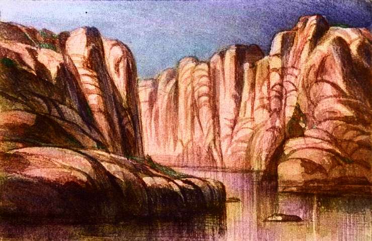
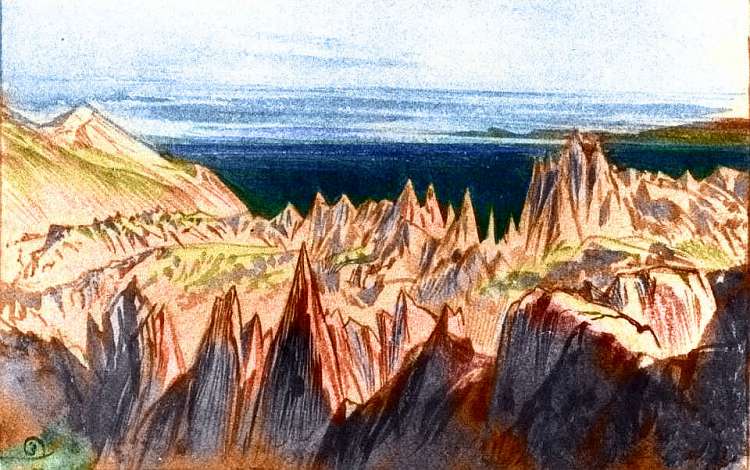
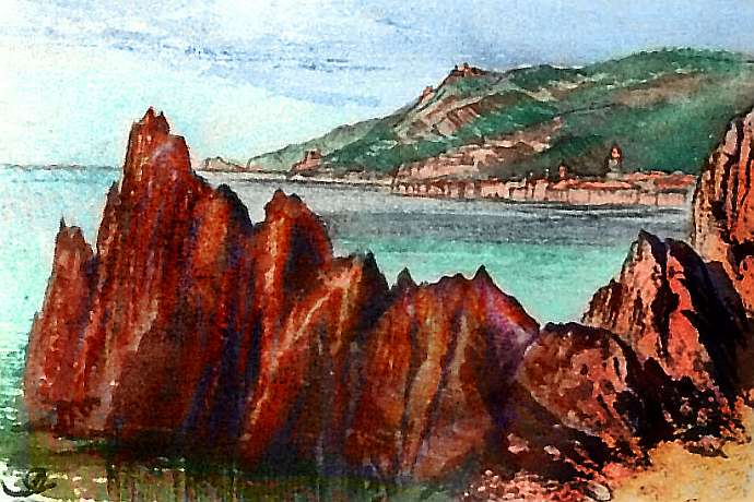
Out on one point, looking across the wide estuary of one river--I've lost track which, by now--are these odd erosional needles. Not that they're representative, really, of this vast horizontal world, but I'd rather draw the interesting exception than the dull average...
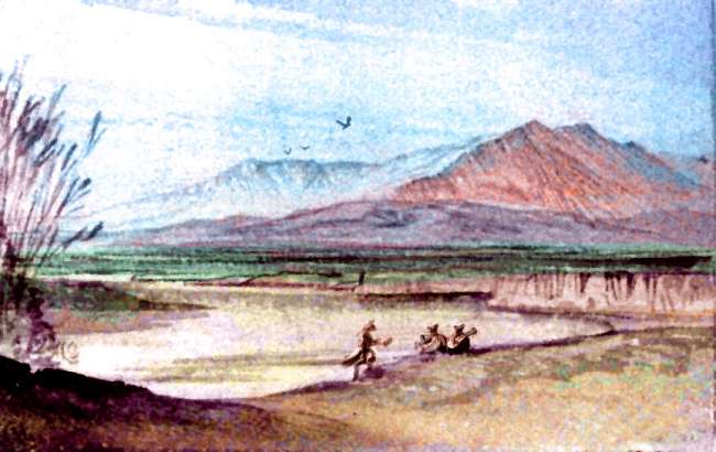
At last--at long last--a taller, wooded ridge heaves up from the infinite veldt, breaking your trance. You hear music. A river ahead. On the bank, a crowd of as many as, say, three musicians! Civilization.
Deja vu! A great, straight slash cradling the head of a gulf or long lake--you're not quite sure which until you skim down to its shore and taste its brackish, slightly bitter, soapy water. A lake all right--neither fresh nor seawater. It's Lake Gonk, a rift-lake some 320 km long and 65 wide (200 by 40 mi). The next dawn you take flight and follow it northwest, up Holkitta Rift. From the air you can see reefs down the middle, built by small volcanoes and hotsprings.
Some mighty strange critters live in Gonk. What do they look like? Oh, I'm shameless: you tell me.
Overview - Names - Fractality - Eastern Isles - The Great Rift - Southeast - South - West - North - Full Circle?
We're nearing familiar country! Brackish Lake Gonk is just a few hours' flight northeast from that gulf where we first crossed Holkitta Rift. But rather than close the loop, we have one more land to see--Cape Fippit, to the northwest.
You ride the updrafts along the west face of the Rift Range. The rift itself is a dry golden valley: a slash of treeless veldt. Every hundred km or so, you pass a sharp, clean, recent cone that warns you: not all crust spreads peacefully. So far they're all dormant, but still... volcanoes dot the rim-ranges as regularly as the bumps on a skinny dancer's spine.
Slowly trees spread from the streambeds. Over the top of the ridge, you can see the distant sea, now; we're on a green-gold peninsula stretching nearly to 40 north: Cape Fippit. Mediterranean climate here; dry summers, gentle rains in winter--or a dusting of snow in the higher mountains. Pleasant country, though not lush or spectacular except right along the coast.
Geography explains why. Cape Fippit is the easiest route to the huge, fertile, temperate island west of Continent 1: let's call it Pseudo-France for now. A certain fraction of the flyway's travelers simply liked it and settled down. But the cultural effects have been profound. Among them: the highest percentage of mixed-species marriages you've seen on Continent 2. What sort of couples? (Not to mention the trios!) You tell me.
And now you're at the end of the tour, the continent, and Holkitta Rift. Where the worldwide riftzone finally splits and fades into geological untraceability. A narrow green island leads like a causeway toward Pseudo-France. It's an easy flyway. Shall we go?
The gazetteer will have a full index of native placenames, with descriptions--once the contests's over and we have natives to name them.
World Dream Bank homepage - Art gallery - New stuff - Introductory sampler, best dreams, best art - On dreamwork - Books
Indexes: Subject - Author - Date - Names - Places - Art media/styles
Titles: A - B - C - D - E - F - G - H - IJ - KL - M - NO - PQ - R - Sa-Sk - Sl-Sz - T - UV - WXYZ
Email: wdreamb@yahoo.com - Catalog of art, books, CDs - Behind the Curtain: FAQs, bio, site map - Kindred sites