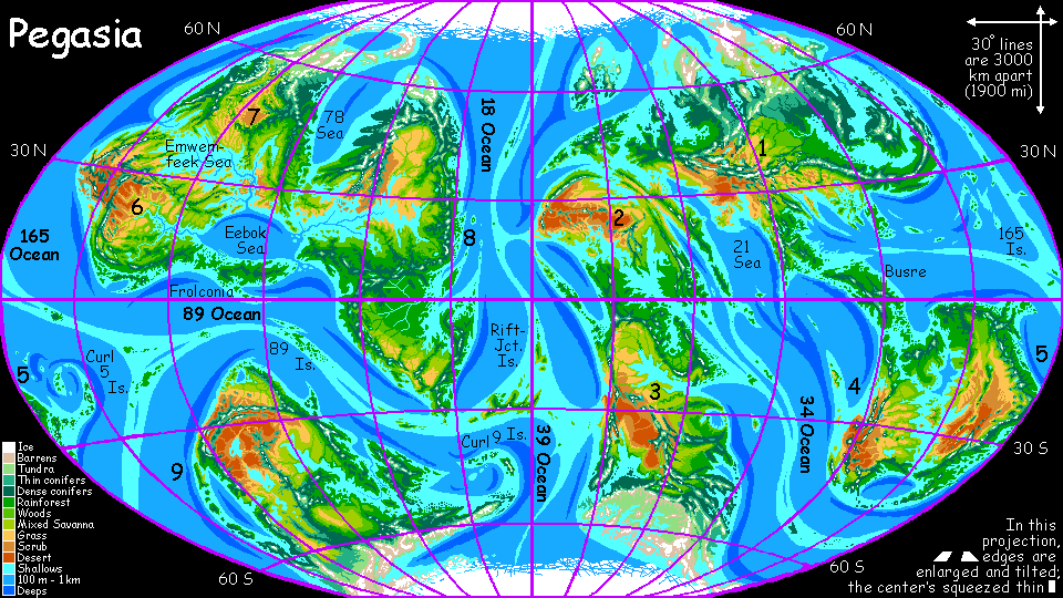
CONTINENT 4 and CONTINENT 5
by Chris Wayan, 2006-9
Pegasia's homepage - Map - Geography & climate - Evolution - Critters - Gazetteer - Sketches - More worlds? Planetocopia!
First-time orientation--strongly advised! Pegasia is weird.
Overview - Continent 4 - Northwest Isles - Continent 5 - Southern Strip - Islet Shortage! - Southern Isles

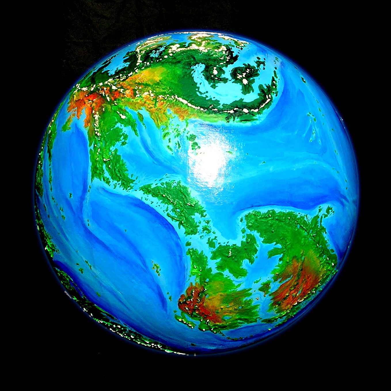
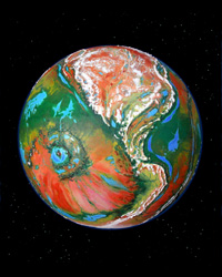
Continent 4 and Continent 5 share the same partly flooded continental platform. To the northwest is Continent 1, largest in the world and gateway to Continent 2 (just visible on the left horizon) and Continent 3 (to the lower left). These five together comprise more than half the world's land, and fall fairly neatly into one hemisphere. Oh--on Pegasia, hemispheres aren't a cartographic convention but an astronomical fact: this is the Outer Hemisphere, facing away from the gas giant Zeus, about which Pegasia orbits. People of this hemisphere, until they begin seriously trading and exploring, will naturally assume they live on a planet. They don't; it's a mere moon, larger than Mars, but still a moon. Only the Inner Hemisphere has Zeus perpetually in the sky--far larger than the sun, brighter than several thousand full moons at night, radiating palpable warmth. Cosmologies and cultures of the two hemispheres will thus be profoundly different. How, exactly? You tell me!
Or maybe not. The eastern tip of Continent 5 and the island arc off its tip, the Curl 5 Archipelago, reach well into the Inner Hemisphere. On the largest of the Curl 5 Islands, Zeus is nearly 30 degrees above the horizon. Impossible to ignore! If winged Pegasians inhabit these islands, word will get round both continents... and quite possibly spread, if only as a rumor, to Continent 1 and beyond. The question is, will they be believed? Will people of the Inner Hemisphere think Pegasia's the center of the cosmos, or a mere satellite?
My personal guess: both. Educated and well-traveled Outerians, and those in port cities and along flyways (land bridges, island chains and mountain ranges athwart the wind, creating ridable updrafts) will meet too many travelers who've seen Zeus face to face. They'll have to accept that their world is a mere moon. What that'll do to their religion and philosophy is up to my readers who contribute species and design societies. You tell me. But Outerians dwelling off the major flyways won't be so willing to demote their world from center stage, not on mere hearsay from a few city slickers. "Those people will say anything..."
Of course, my answer is biased. I live on a continent where half the population thinks they ascended from apelike creatures over several million years, and the other half thinks they descend from clay figurines molded by a bearded sky-deity 6000 years ago. So I tend to expect nominally intelligent creatures to deny uncomfortable facts... more or less indefinitely.
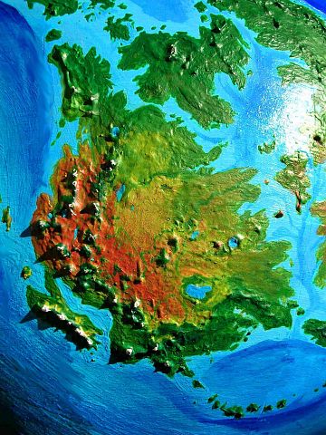
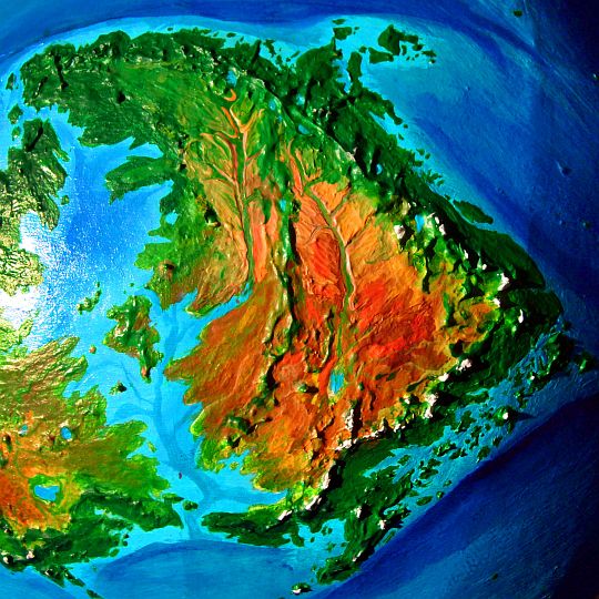
Whoops! I digress. The Twin Continents, the Twin Continents... well, think of them as a big, flooded, split Australia. They're nearly as isolated, and they're pretty dry by Pegasian standards. Still, that huge sea flooding much of the interior makes a big difference in climate--the interior is way more fertile than the Outback.
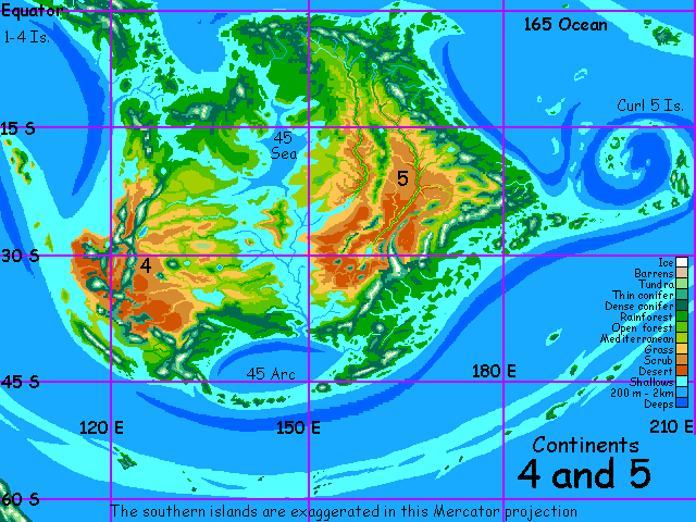
Of course, in colder eras, when the icecaps grow and the sea level drops, the central sea dries up and the Twin Continents become Australian indeed--green shores around a vast red desert. But far bigger--in fact, bigger than Africa! Its fertile shores alone, at those times, are bigger than all of Australia.
But I prefer the Twin Continents in interglacials like the present; the weather's hot, and the inland desert's still extensive, but it's not a dustbowl; and that inland sea is a wonderful place, full of Mediterranean islands and sounds, bringing rain and milder temperatures to the desert, and damping down the dust.
Here we describe the western half--the smallest of the nine continents. This is just a stubby placeholder for the full tour to come, of course.
Let's start in the far north, near the equator. Northern Continent 4 is rugged: several volcanoes here often have snowcaps despite their latitude. Coasts are rugged and indented: lava flows meet the sea, and, battered by typhoon-driven waves and eroded by heavy tropical rains, they erode into steep green canyons and knife-edge ridges, as along Na Pali Coast on Kauai.
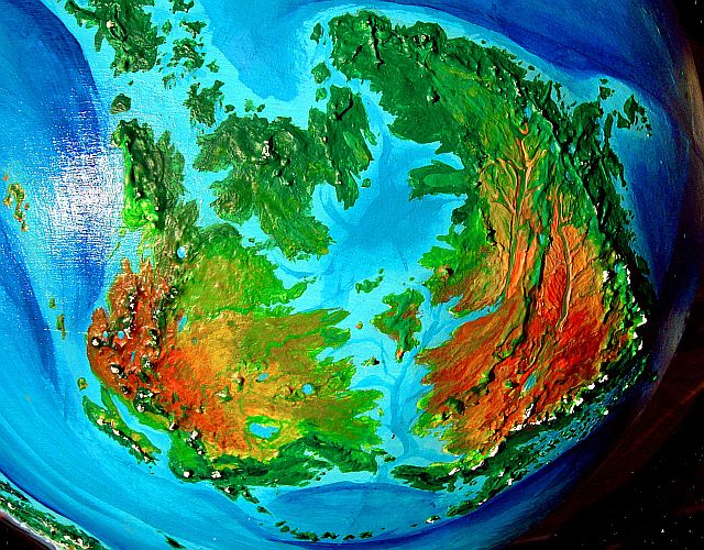
The Busrehi, the species dominating that long, New Guinea-sized island (which they call Busre) northwest of the Twin Continents and forming a flyway to Continent 1, have in recent millennia colonized the rainforests of Giithe, that huge island between the Twin Continents (top of photo). The Busrehi will settle the forest canopy of northern Continent 5, too.
I'm certain that the inhabitants (if any) of the wide savanna plains to the south--the Sahel of this world--will be another species entirely. It has to be able to endure heat and thirst, for rain here isn't reliable... and heat is. Cameloids with hands? Or a bipedal dino with a heat-dispersing frill? Whoever they are, they'll be skinny, leggy, and probably nomadic, but beyond that... you tell me.
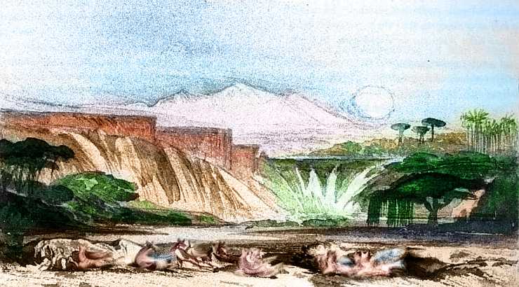
It's possible that these plains are hinterlands, and all the cultural action here is along the rivers; fed by reliable snowmelt from the western coastal mountains, at least five mini-Niles cross the arid plain in shallow canyons, west to east. Ideal for irrigated farming. Not city-states but strip-states?
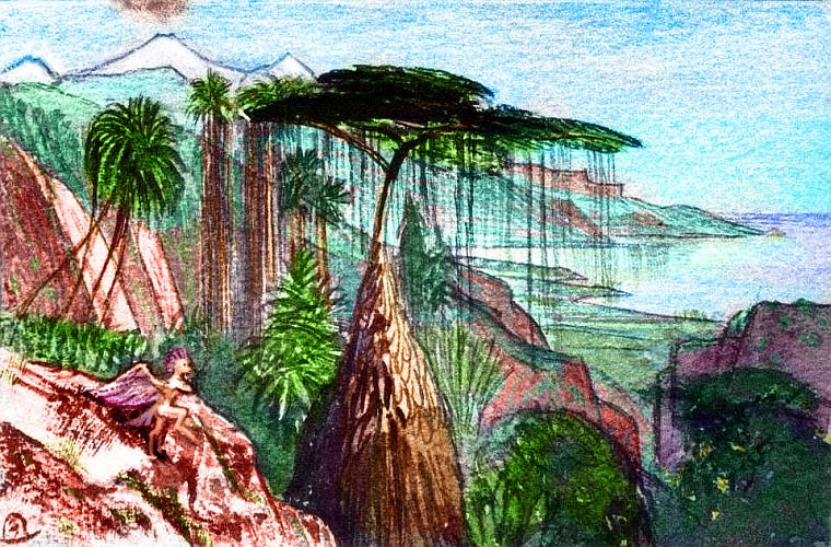
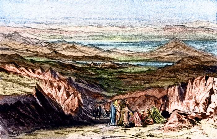
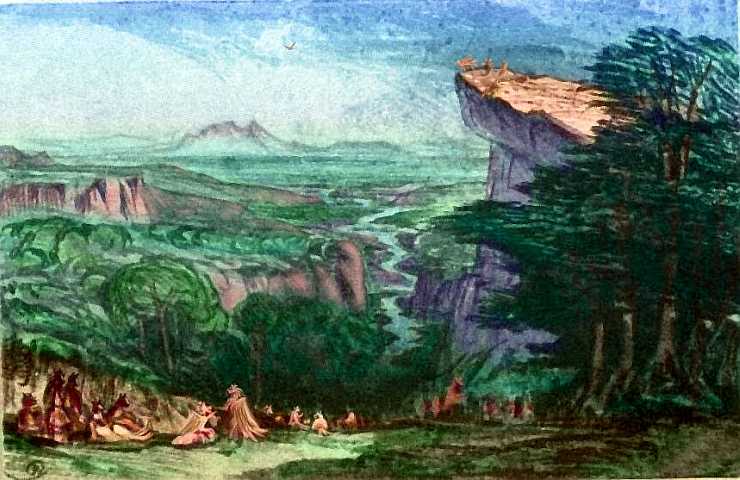
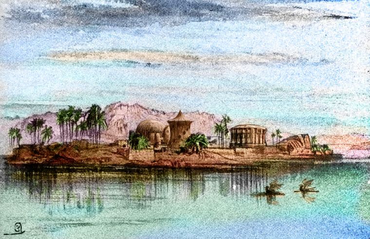
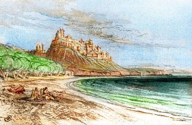
These five Niles, like their big Terran sister, have cataracts and low falls, making them poor for navigation, but quite scenic as well as long oases in the savanna and desert above. Below is a sketch of the upper falls on the middle river; I don't know if that sprawling crowd in the foreground are dingos, deer or kangaroos; people or domesticated animals or wild things; locals or tourists like you. I left them rough and blurry... just in case.
On the horizon is one of the other distinctive features of Continent 4, making it very different from, say, the Sahel or the Outback: a sky island.
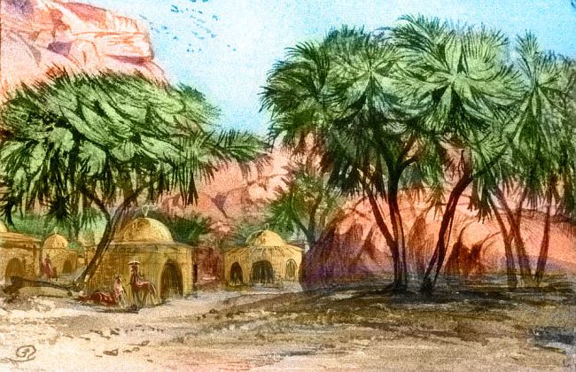
Over much of this plain especially in the drier west, small isolated mountain ranges dot the red desert, snagging enough of even this latitude's stingy rains to create a whole flotilla of green (or at least olive) sky-islands. So maybe Continent 4's population won't be so concentrated along lowland rivercanyons after all. Every sky-island will have villages tucked away in its canyons, where creeks descend...
The sketch below shows only one hamlet of a thousand; maybe these lanky people with their parasols dominate this desert, or maybe they're an obscure little tribe in a land of velociraptors or giant bees. You tell me.
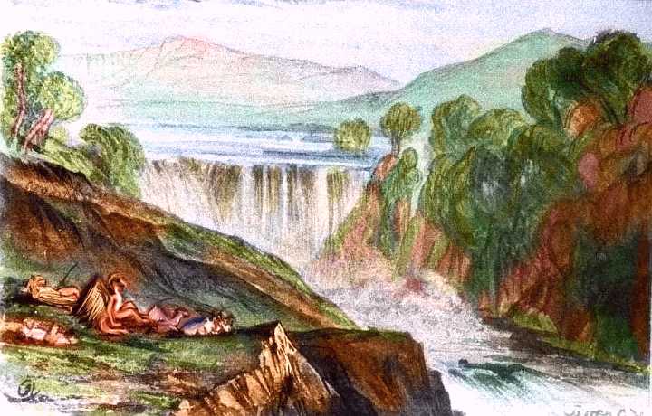
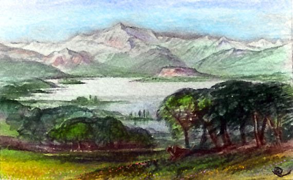
Still further south, on the last of the five rivers crossing the desert, is a still larger lake. Shallow and bean-shaped, it's clearly not of meteoric origin. But a lake this big (120 by 220 km, or 75 by 135 mi) generates its own local weather. The river entering the lake has twice the water that exits; the rest evaporates, humidifying the southeastern plains. Downstream is semiarid scrub and savanna; the desert ends here.
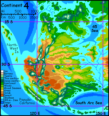
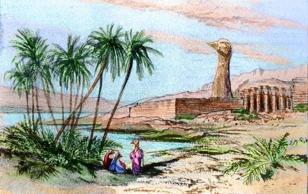
Over the mountains to the south is a third zone, a Californian coastal strip. It's the size, climate and even approximate shape of 22nd Century California, with a narrow inland sea much like the one we'll have after we've finished busily melting the icecaps and flooding the Central Valley. Of course since Pegasia's been in a warm phase for many centuries, this isn't catastrophic but a blessing. Instead of a hot dry Central Valley, the Inland Sea's shores are mild, maritime grasslands and groves--a gigantic San Francisco Bay.
Its geological origin may even be Californian. Notice how Pegasia's ubiquitous offshore trench system fades away just as Pseudofornia's mountains rise. Two geological possibilities:
Despite Pseudofornia's relative isolation, I suspect it'll advance faster than surrounding regions; a society with minds of many species will innovate in ways we can't imagine. Humans, after all, differ only in culture, really, not fundamental outlook; functionally they're rather interchangeable. Different species, though, may live in profoundly different sensory worlds, and may have unique mental abilities--one with strong spatial imaging, another strong on verbal logic, others who live by intuition, or smell, or a global social sense. Who knows? I'm not going to say you tell me again. No.
All I'm sure of is: it's going to be an interesting region.
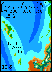
This little section's a Wikipedian stub--just a reminder to myself. I need to research those islands to the northwest! They're as big as Sri Lanka, after all And I think the people of Continent 4 will have discovered them; there are islets halfway out. (Islets indeed! They're nearly as big as Hawai'i! It's hard to keep a sense of scale when looking at these sketchy maps...) All I can tell you at this point is that their highlands and southeast shores are rainforest while the lowlands and northwest shores are dry, with pleasant borderzones between, of mixed woods and savanna.
This isn't arbitrary; it's the pattern (flipped north/south) of Hawai'i or the Cabo Verde Islands, writ large. Steady, prevailing winds, here from the southeast, driven by rising air along the equator, make the storm-patterns inevitable at this latitude. In maritime regions, Pegasian climate belts are really quite Terran; it's only inland and at the poles that the differences become truly noticeable. Even there, it's not so much climatically alien as exotic-looking: lurid eclipses every noon, thunderstorms each afternoon, auroras every night... if you can call that night, with huge Zeus hovering like a psychedelic blimp and Tharn flitting about blinking red and green like a schizophrenic Mars...
Sorry, I did intend to make a point (of course the road to hell is paved with you know what). Point: despite all the surface exoticism, the climates and even microclimates on islands like these are surprisingly predictable. Who lives there is less so, and that's intentional--I want you to tell me. Culturally, are they Bali or Sicily, Haiti or Hawai'i--or simply not comparable to anything Terran? The only hint climate gives us is that the islands have diverse habitat.
Like but unlike Continent 4; the differences are subtle. Continent 5's more isolated from other lands, though still not as lonely as Australia. So many Pegasians fly that news, seeds, ideas and offspring all spread pretty quickly for a low-tech world. Pegasia, due to its low gravity and high air pressure, just can't be as tribal as Earth. Flight alters all.
So I think the real divide here isn't the straits between the twins--reading maps that way, indeed our very concept of a continent, arises from our ground-animal heritage. Pegasians, being mostly fliers, will probably name regions based on climate and biota. Here, they won't see two continents but four regions:
Well, one group might: semi-aquatic creatures/people fishing along rivers and coasts. There's certainly plenty of it--the stretch between Busre Island, Giithe Island and northern Continent 5 is so fractal it's almost Indonesian. Fishers might never need set foot in that gloomy green understory. Or paw or claw or wet pulpy tentacle... you tell me.
The east end of this rainforest shades into a long subtropical borderzone along Continent 5's northeast coast. This coast's climate is milder than Northern Australia's drought-then-deluges, but rains here do alternate between steamy stormy summers and mild sunny winters; tall forest, but way more open than the equatorial belt.
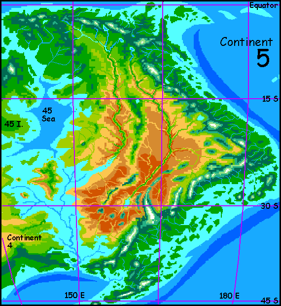
Though I do see one difference between the eastern and western deserts. Nile-like riverine cultures may develop in the deserts of Continent 4, but they're a near-certainty on Continent 5: two great rivers collect all the sparse runoff of the interior and wind through great canyons for 2500 kilometers.
The western one reaches the inland sea; the eastern ends in a salt lake in the south. On Earth, the latter would develop an isolated culture, perhaps even isolationist; the western riverdwellers can engage in sea-trade after all, and the easterners can't.
But flight changes all; news, light trade and migration don't just follow shipping routes on Pegasia. Both rivercanyons may be cosmopolitan oases--and shortcuts across the desert for those impatient with the long way down and around the coasts. For the adventurous, riding the hot winds above those rivercanyon walls may be just as fun (certainly as scenic) as the mountain-updrafts of the east coast.
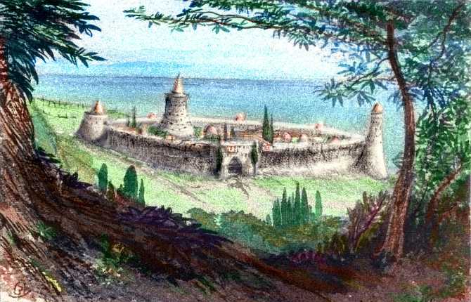
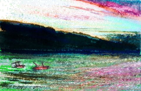
Here's a sketch from the upper reaches of the western canyon, the one that eventually reaches the sea. I don't know if the winged creatures wading in the shallows in the foreground are farm animals or the builders of these structures; you tell me. The wasp-waisted towers seem to be layered brick or stone with wood beams. Heavy for Pegasia; perhaps this is because the river's away from the coastal ranges and their associated earthquakes.
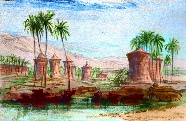
Hard to tell from afar, and we dare not walk those streets yet. Wouldn't want to collapse the sheaf of biopossibilities prematurely! We'll just have to wait and see what you tell...
Here, those same winged creatures appear to be riding logs and propelling themselves with flaps of their wings. Fishing, maybe, or just playing? In any case it suggests intelligence. But who they are and whether they built any of the domes and towers in the background, I don't know. Maybe they're children playing in the ruins...
In contrast, here's a sketch from halfway down the eastern river canyon. Different people, that's for sure! And apparently a monoculture, at least along this stretch.
Are those really robes? Almost kimonos. Seems like they'd interfere with flight. Have these people, safe and isolated in their long oasis, lost the need for flight, like some island species on Earth? They look ungainly enough! But then so does a goose until it takes off. Perhaps the robes are merely a ground-uniform, for decoration, modesty, status, or to protect against that fierce sun--something to be dropped as soon as you take to the air.
Well, whoever these people are, they've clearly been around a while. And build in stone.
But I don't know much about what we do get. Here's a sketch of a coastal town, though I'm not sure which coast. No, wait--by the angle of the sun, I think we're looking west, so this would be Continent 5. And I suspect we're near the mouth of the great rivercanyon that does reach the sea. Why? Well, though these people use more timber with their stone, and no mud-brick like the desert-canyon peoples, those wasp-waisted towers look familiar. A stubborn desert tradition adapted to a different climate as the desert culture extends downstream, or an architectural motif borrowed for prestige, evoking a glamorously extinct civilization in the minds of a quite different people? Won't know til you tell me.
Elsewhere on Pegasia such beasties are not evident, though I'm sure at least one existed on each continent--it's such an obvious strategy. But here on Continent 5, at last around the inland sea, they seem to have survived. Do they provide some service or benefit?
No, smartass. I mean beside the dung.
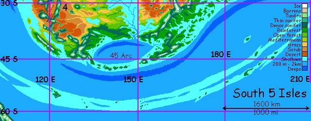
The South Arc Islands will also develop their own culture, as distinct as ancient Northern Europe was from the Mediterranean, and for a similar reason: snow. The islands face strong winter storms, and people will have to build accordingly. Not long or hard freezes by Earth standards--at present Pegasia lacks anything like Antarctica or even a Greeland to generate real blizzards. But still, to find a coast this cold muddy misty rainy and generally wretched (by Mediterranean standards) you'd have to fly all the way through the Twin Continents, along 1-4 Island, and north across huge Continent 1.
Because that cape's not a dead end: from it, reef and islets lead east to the Curl 5 Archipelago, and beyond: they lead, via some strenuous island-hopping, to The 165 Islands and huge Continent 1, far to the northwest. They may also lead northeast to Continent 6 in the Inner Hemisphere. Or to huge Continent 9.
Or to death. I'm just not sure; the orbital photos don't show large islands all the way, but the visible island-chains and shallow water both hint there may be islets creating a risky flyway...
My gut tells me that the photos I'm relying on are misleading. A world this tectonically active, with seas this shallow, should have more islands than these orbital shots are detecting. The rift zones should create more skinny islands down the middle of the seas, and lesser hot-spots should create many transverse island-chains, not just the few I see.

I know why they don't show such things: the globe of Pegasia I built has relatively gentle sea-floors, because last summer I hadn't seen really modern, detailed, accurate regional maps of our sea floors. The seas in most atlases and world maps (even new ones, even Web ones) are deceptively smoothed out--no one but oceanographers will catch the omissions or complain, after all. But there are a lot more seamounts and volcanic chains than you think, or most maps show, and more being found every day... On a world with seas as shallow as Pegasia's, way more of these would break the surface.
And yet... revising Pegasia's geology and geography would mean redoing the physical globe, AND either reshooting or tweaking the orbital photos, AND correcting all the maps. Ugh!
And yet, and yet... they don't have to be big, but I think we're short about a hundred volcanic islands.
And yet, and yet, and yet... I don't want them. It's not just laziness. For evolutionary reasons. I don't want it too easy for the winged inhabitants of this world to hop between continents. If stepping stones are everywhere, they're not special anymore. If the whole world's easily reachable, goodbye adventure! And speciation, and cultural diversity! The fun of a world like Pegasia is to discover the flyways, the bottlenecks, the pressures on life and culture. The walls as well as the doors.
Restriction shapes civilization as much as it shapes life itself, just as limitations shape art. Including planetary sculpture like this.
So I'm putting off the decision for now. Maybe forever. Besides, I'm too distracted by that central sea. Mmm, looks warm. Club Med! I want to go swimming there now... Don't you?
Just a second reminder to myself that I need to research these islands to the far south. There are even more of them off the edges of this regional map--off the edges of all the regional maps, for they run right down the middle of the southern sea, marking a stretch of rift/ridge where crust is spreading far from any continent. I have my doubts that Pegasian fliers will ever discover them, they're just too far out. Mariners, perhaps, eventually. But mariners on Pegasia won't be explorers in our sense, but practical shippers plying known, profitable trade routes with loads too heavy or bulky to carry by air. Will they find these islands either? They're about the most isolated spots on Pegasia. I know. I'd forgotten them myself until the fifth rewrite, though they've been there in the orbital photos since day one.
Pegasia's Galapagos, and I don't know a thing about them.
Now, now. Use your reason. OK, I know two things:
So instead of sub-polar iceboxes, this is a cool-temperate belt. Currents are warm for the latitude. Snow falls only for a couple of Earth months (true, that's nearly a third of the Pegasian year, but it's the absolute length that really matters for animal life: will you starve/freeze/go crazy, or not? In these islands, not.) More England than Patagonia.
In fact, life should be easy along the coasts. Kelp-forested coves where you don't even need to fish--just collect seafood off the rocks and from the pools. Add half an hour in the berry patch and you're ready for a feast. True, you'll want a stout warm lodge to feast in. But the wood is there--maybe not the soaring cedars of British Columbia, but Finland at least.
The real question is, will anyone at all be here to enjoy it? You tell...
The gazetteer will have a full index of native placenames, with descriptions--once the contests's over and we have natives to name them.
World Dream Bank homepage - Art gallery - New stuff - Introductory sampler, best dreams, best art - On dreamwork - Books
Indexes: Subject - Author - Date - Names - Places - Art media/styles
Titles: A - B - C - D - E - F - G - H - IJ - KL - M - NO - PQ - R - Sa-Sk - Sl-Sz - T - UV - WXYZ
Email: wdreamb@yahoo.com - Catalog of art, books, CDs - Behind the Curtain: FAQs, bio, site map - Kindred sites