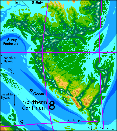
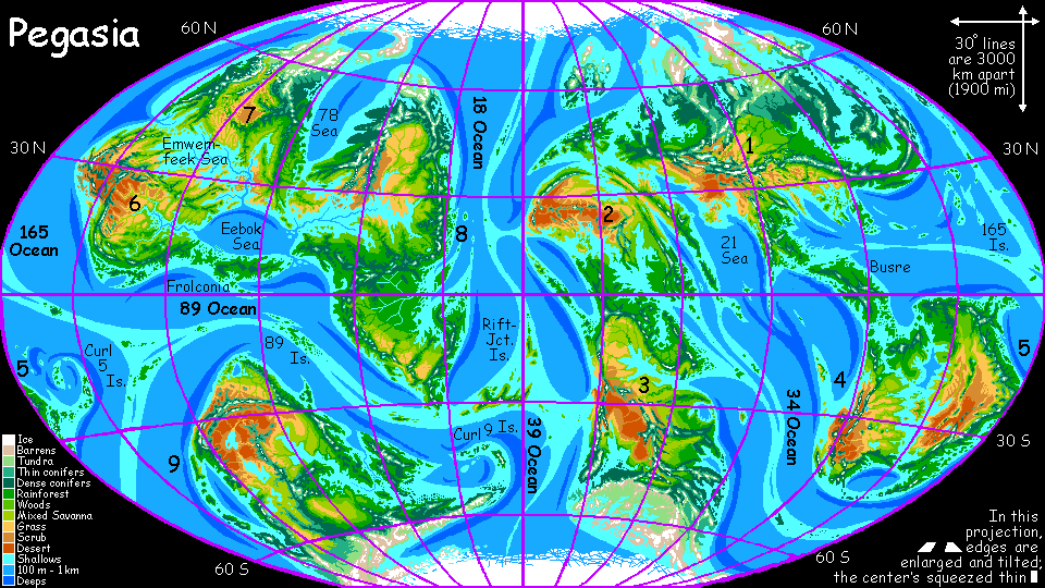
CONTINENT 8
by Chris Wayan, 2006-9
Pegasia's homepage - Map - Geography & climate - Evolution - Critters - Gazetteer - Sketches - More worlds? Planetocopia!
First-time orientation--strongly advised! Pegasia is weird.
Overview - Desert Isle - Temperate North - Eastern Spine - Grecian Gulf - Steamy South - Jumpoff
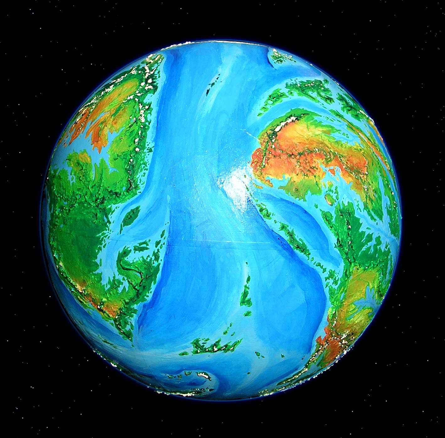
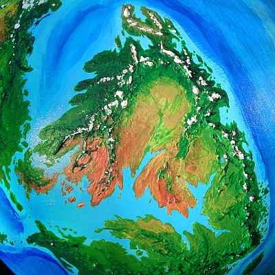
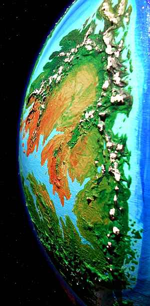
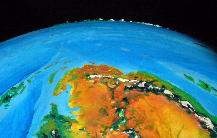
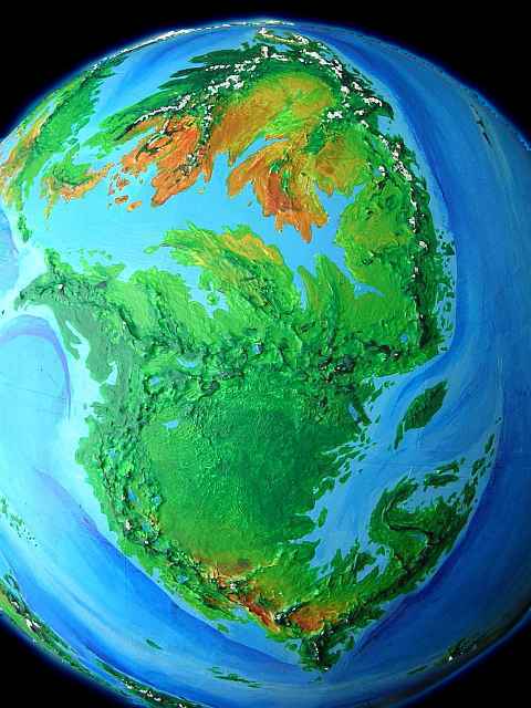
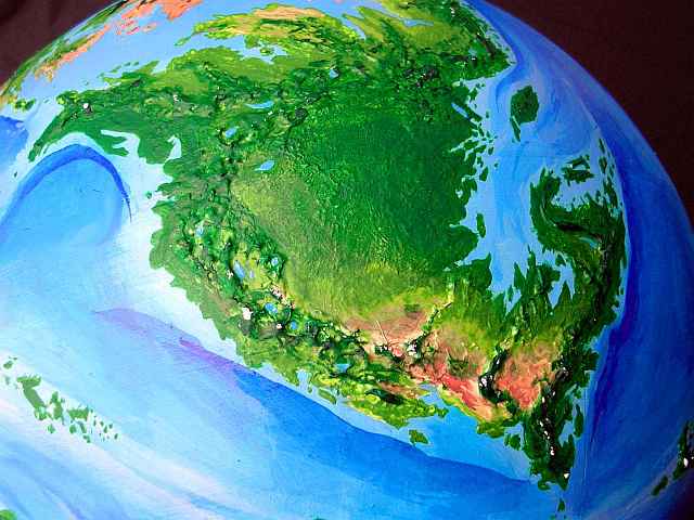
Continent 8 is the eastern edge of the huge tri-continental platform dominating the Inner Hemisphere, where Zeus is always above the horizon, causing a long noon eclipse and making the nights no more than dusk. In the high-orbital photo below, Continent 8 is the long, two-lobed land on the upper left.
To the right are Continent 2 and Continent 3 in the Outer Hemisphere. That's Continent 9 way down south; it's both geologically and biologically a land apart.
During ice ages, when sea level is lower, Continent 8 fuses with Continent 6 and Continent 7 (not in the high-orbital photo; they're just over the left horizon) to form a single mass with green coasts but a vast inland desert. In the current era, shallow seas break up the platform; less land, more biomass.
Continent 8 is nearly as big as Africa--as big as both its close neighbors (Continent 6 and Continent 7) put together. It's a north-south strip cutting across many climate zones, much like Continent 3 in the Outer Hemisphere, or our New World.
Jared Diamond argues convincingly in Guns, Germs, and Steel that people on such a north-south strip have diverse life-strategies and cultures, because climates and day-lengths and seasons are so different even a few hundred kilometers up or down its long coasts. But for the same climatic reasons, that cornucopia of domesticated plants and animals they breed can't spread quickly north or south. On Earth, it took a thousand years to adapt Mexican maize to, say, Ohio; potatoes never made it through the tropic barrier. Meanwhile wheat spread from Spain to China! East-west is easy. Continent 8 may be handicapped.
Of course, moving a bit inland may solve the problem: Continent 8 has a sinuous mountainous spine its full length. Though more broken and lower than the Andes, it's tall enough to cause huge variations in temperature and rainfall. When it comes to crops, altitude (as the Inca knew) often conquers latitude.
Continent 8 may look like the Americas, but looks can deceive. The Aztecs and Inca never traded, and may not even have heard more than rumors that another great empire existed. Such isolation is inconceivable on Continent 8; in the low gravity and dense air, Pegasians will have evolved to fly. Like migrating birds on Earth, they'll follow hillcrests, riding the winds, slamming into windfarms... wait, we'd better not invent those. Lawsuit city!
So the rugged spine of Continent 8, standing across the trade winds, isn't a migration or trade barrier, but a flyway. You can ride its updrafts from equator to pole in a couple of weeks!
So the people you meet, despite very different lifestyles, won't be strangers, but parts of a continental network of travel and trade and news. Even different species will all speak a common trade language along with their own--if they retain distinct languages at all. The whole continent may share a common tongue, though doubtless enriched by local terms.
Overview - Desert Isle - Temperate North - Eastern Spine - Grecian Gulf - Steamy South - Jumpoff
We start our tour hundreds of km off Continent 8, on the southern tip of Continent 7, staring across the strait at the huge island called Ebchok-t-chak. Not that you'd guess it's an island, even from the air; it's so big you'd assume it was mainland Continent 8 until you peek at the map.
For fliers, Ebchok-t-chak is by far the best bridge between eastern Continent 7 and Continent 8. Some of the maps still call it 78 Island; that's because the Pwokwe term for it is not just cumbersome and difficult for outsiders to pronounce correctly (the ch is more like an angry bluejay's rasp than any human sound; and the t is a echoing pock like water dripping in a well), but their footprint here is very light: just a few small ports on the south coast. This is the very edge of their trading zone so far; it's too dry for the Pwokwe, really. So if you design some locals of a species better suited for these warm dry hills--someone who can survive a long dry season grazing on grass and brush, perhaps?--then your people's name would take precedence.
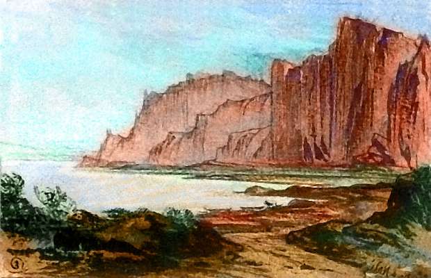
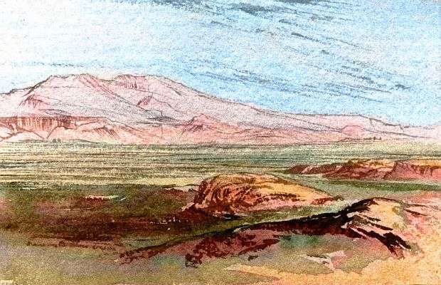
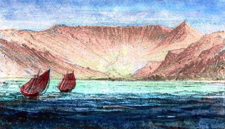
Let's cross the narrow strait from Continent 7--it only takes half an hour. Our landfall is on rocky bluffs breaking through short scruffy woods and brush. This tawny land is like another world after the lush east coast of Continent 7. Why's this island's so much drier? Continent 8 is upwind, and its mountains snag storms and pre-empt their rain. The latitude's partly to blame, too: we're close to 30 north, a high-pressure zone discouraging storms, where rain is generous only if a good stretch of ocean lies upwind--the 67 Sea has narrowed from thousands of kilometers to a narrow split tongue.
Result: the north side of the island but Mediterranean but dry; and the south shore is close to desert, with tall red cliffs. Water, water everywhere, but none of it generates much rain...
Let's head up there, over dreary flats and low hills. Higher, until we find a drinkable stream and shade for our afternoon siesta. Stony, in places dramatic, with at least scattered trees, the hills are something of an oasis after those dry flats. Still, they aren't that promising. If I were a native flier, I'd put my villages on the coast, in a cove where a stream reaches the sea. Of course the Pwokwe have hogged several of the best such harbors already. Since they don't fly, they have to have truly safe havens for their boats; fliers can afford a bit more risk. "Abandon ship" isn't quite so dreaded when you can ride the wind back home.
There's a greener, more promising island just to the northeast. Or maybe more than an island. Yes. It's the tip of Continent 8. And I promise, if we head north, it'll get greener fast.
At least fast on the wing. If this were Earth, and we had to walk...
Overview - Desert Isle - Temperate North - Eastern Spine - Grecian Gulf - Steamy South - Jumpoff
Continent 8 is split into northern and southern halves. The north isn't shaped much like North America but has much the same ecological arrangement: prairie heartland, wooded coasts, Canadian north, desert southwest. The eastern mountains are much higher than the Appalachians (ice-capped in places) and they block eastern storms, so the central prairies and hills are noticeably drier than the Mississippi Valley; but all in all, the parallels are considerable.
Let's begin our tour of Continent 8 in the far west, at the island-choked strait from Continent 7.
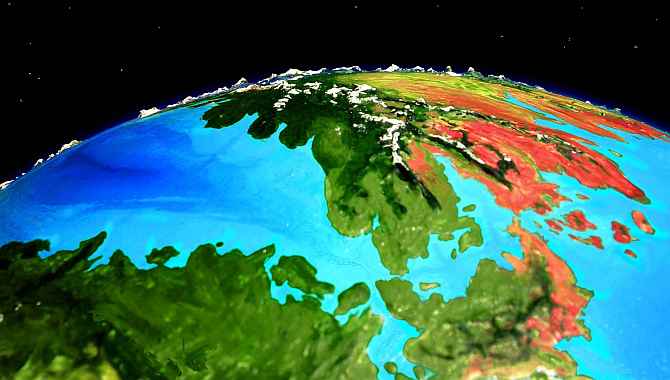
We head northeast along the shore of the cool 78 Sea, between Continent 7 and Continent 8. How's the climate here? Wet, I think; a strong current will flow north through this sea, though it'll likely hug the Continent 7 coast, with a weak southerly back-current along this shore. But the warm water will generate moist air: year-round rain, as in Ireland or British Columbia.
So although Cape Nwok on southern Continent 7 and Ebchok-t-chak are rather Mediterranean, over our first day's flight northeast the scattered groves and creekside strips of woodland spread and fuse to dense, tall forest--evergreens, or the Pegasian equivalent.
Soon, the only relief from these dark forests are peculiar streaks of bright flowering trees along rich valleys and on a few sunny ridges. These aren't natural, but plantations! The local people, being arboreal, doesn't "clear" fields of trees (what a euphemism! Almost as good as "ethnic cleansing"!) but tends fruit and nut orchards as tall as the natural forest, and plants fruit-bearing vines that climb trees on the slopes, making the canopy quite productive while not disturbing watersheds. It's an inaccessible world for humans, who can't get around in tall trees; but these winged climbers rarely even visit the dark ground below.
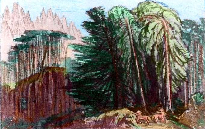
I can tell you about the locals' sylviculture, and even a bit about their culture (they think in three-dimensional nets, like the branch-mazes they must get around in; to a human, odd leaps of logic) but nothing about how they look. You tell me. Invent a species. They'll have plenty of room: these woods stretch unbroken all the way to the Arctic! Even the northern tip of Continent 8 has low, sparse Alaskan woods in spots, beneath its snowy volcanoes.
But let's not go that far! It's a long detour and a dead end, unless you want to hop along the Arctic islands (the size of Japan and as rugged as Alaska) to northeast Continent 7. Brrr!
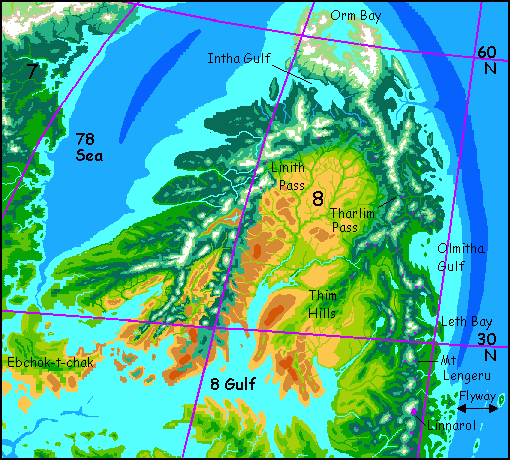
So instead, around 45 north, we'll veer inland over Linith Pass. If we can; it's the best I can manage, but still very high, above the local treeline. Not even alpine, really: the pass is a jumble of house-sized boulders hacked off by glaciers and dropped in the last great thaw a few million years ago. Not even frost-heaving and cracking has managed to do much to these monsters. And the range is still uplifting...
Hours of steady climbing until you're gasping. If you could think coherently in such thin air, you'd think "I can't be suffering from altitude sickness--the air here's so dense!" And that's true; Pegasia's 1.6 atmospheres may have thinned to little more than half that, but that's still no thinner than Denver's or Mexico City's; you shouldn't be fainting. Your problem is twofold: you're not riding a bus or hiking, you're trying to fly in thin air... and by now, you've spent at least a week near sea level, and your blood's thinned in response, to protect your tissues from over-oxidation. Your blood's watery orange!
So you gasp and flap, skimming the boulders, using the ground effect--a flier hugging the ground can trap a high-pressure bubble between wing and earth--or boulder. Extra lift for the desperate! And you are.

Well, they better be golden; if they're dusty red we're in trouble. I led you this far north precisely to skirt the worst of the desert. Up here, glacier-melt rivers vein the prairie even in summer; finding water won't be the headache it is in the southwest, where snows melt by summer and streams dry up.
Who lives on these northern plains? Not the forest people--almost certainly a different species. The economy will be based on harvesting the endless grass... but are they grain farmers, dairy herders, meat ranchers... or people able to graze the land directly? You tell me.
What's that old poem? The Lion and the Unicorn were fighting for the crown... Here, lions (or wolves or humans: hunters), unicorns (or zebras or elephants: bulk herbivores), centauroids (omnivorous browsers like chimp/bonobos), and half a dozen others all seem like equal contenders...
Of course, this whole notion of competition for a "crown" of dominance may be mere human prejudice. Why should one dominate? Maybe they're all winners. The local civilization could be a mixture of all of them--one or more local species plus settlers from the coastal peoples, each with a different, complementary adaptation.
Such a society would have to be more robust than our thin, unstable (and destabilizing) monocrop of humans, with only their animal slaves and sycophants (no, no, not all domestic animals are slaves. Don't underestimate the power of evolutionary strategies like helplessness, ass-kissing, and biiiiig baby eyes! There's this yappy chihuahua down my block...)
Now comes a difficult bit. We need to cross the great plains east to the coastal mountains. It'll only take a long Pegasian day or two, for Continent 8 isn't North America or Asia. The steppes here are only hundreds of km wide, not thousands! But I warn you: it'll feel long.
You see, the prevailing summer winds are mild enough, but steady--and they blow from the east right into our faces. It'll cut your speed by a third. Not many updrafts to ride, either, over these plains... except around thunderstorms, of course! Not recommended! Time to earn your tour with a little muscle work.
It's a few days later. Dawn. Pink snowcaps gleam ahead like icing on the black silhouettes of the Eastern Range. Your shoulders ache--still haven't adjusted to such relentless strain. On most Pegasian tours I've followed the local flyways, but here we had no real choice--it was this or face twice the mileage up in the subarctic, still with headwinds, but also full of no-see-em bugs.
Believe me, this is better.
So we beat tiredly up slope toward Tharlim Pass into the Eastern Range, under volcanoes miles high. Now you know in your bones (shoulderjoints, anyway, and your elbows are starting to ache too) this isn't just a thinly fictionalized precolumbian North America--these really aren't the Appalachians! Continent 8 has a Cascade-type range (and a subduction trench offshore renewing those volcanoes) on each coast. Continent 8, like many on Pegasia, isn't drifting on its plate; it's being squeezed, hard. And breaks out in boils!
Boils the size of Kilimanjaro.
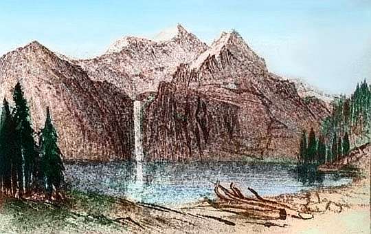
It's a long hard climb against headwinds up to Tharlim Pass. First rolling prairie foothills, then parklands, then somber forest breaking into bright alpine meadows. Waterfalls pour into lakes shiny as coins. Cloud-wrapped, ice-capped giants loom.
Lovely country, but you're so tired. More tired than you ought to be. Oh! Altitude sickness again--and the thin air makes it hard for you to stay aloft. Tharlim Pass is even higher than Linith: you're about 4.5 kilometers up (15,000'). The air pressure's half what you've grown used to; merely Earthlike, and you can't fly there, can you? Just not enough muscle power to support your weight. Yet here you are, with your rented wings, still in the air--such as it is! Pegasia's low gravity is the only reason you're still moving.
No, not the only reason. It doesn't feel quite as bad as Linith Pass! It's a tribute to your days of practice against headwinds on the plains that you can stay aloft at all.
Overview - Desert Isle - Temperate North - Eastern Spine - Grecian Gulf - Steamy South - Jumpoff
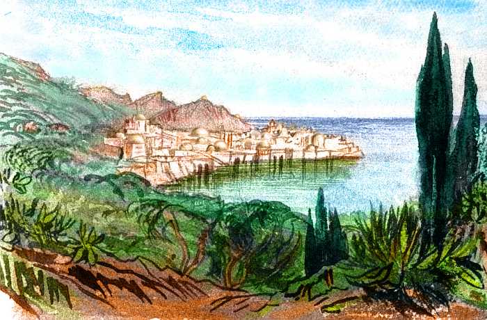
Below you sprawls a rich rumpled country. Green capes shaggy with deciduous forest, blue sounds dotted with islands. Meadows slope down to lakes with towers on the shores...
You race down the slope in a miles-long hawk-dive, glorying in the feel of solid air under our wings. From 40 kph to 150; from gasping to breathing free. Like breaking out of quicksand!
Eventually whole paragraphs will be here, describing this complex and fertile coastal strip in more detail--the maze of hills crowned with stone castles at places seemingly chosen for spectacle not logic or defendability, the slopes covered with orchards, the flats full of deep wild lowland forest around rich marshes apparently preserved for hunting or fishing, the sloughs feeding into sounds. Intricate.
This easy flyway, where the tradewinds off the sea hit that mountain wall and rise, will foster a unified civilization all along this coast, not separate little cultures in each rivervalley and island--that's the pattern natural for flightless animals like humans, but here? No way!
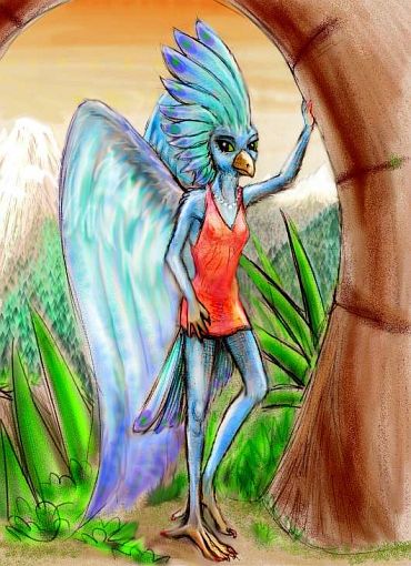
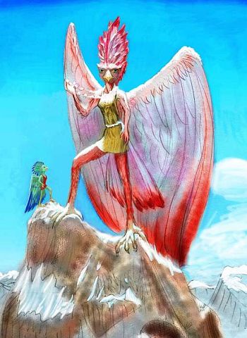
Who lives here? This last year, I got my answer from Erik Adler: the Aviatrica, as their name neatly translates--matriarchal fliers built to take advantage of those continent-spanning updrafts. What's an Avia look like? Just stick a blue heron and an angel in a blender... stretch to seven feet tall and there you are!
No, that's not a prom dress, just an everyday tunic--the Avia love bright color and associate red-orange with their cultural founder Linlarku ('Spirit of Compassion') or Thironu ('Horizonseeker'; a real historical figure with reddish wingfeathers).
Wheeling right, you sail south all day, winding through deep-cut valleys and gorges below great crags. Waterfalls. Toward nightfall you land in an Aviatric hill town and sleep the sleep of the exhausted. Not that riding the winds today was that hard--Tharlim Pass just wiped you out.
Next day you reach Olmitha Gulf. Skirting that take you two days. Ride the winds south. The Aviatrica, of course, zip by you at twice your speed. That's all right. Take your time. Wind isn't oil; it won't run out. On Earth there is no free lunch, but on Pegasia there is free transit. With practice.
Halfway round the Gulf is a pass back west, guarded by an Aviatric city, Thim Pass. We'll stay the night. You notice that the sunset silhouettes more high mountains on the western horizon, not the sea of grass you expected. They're the Thim Hills, a long sinuous spur winding southwest from the Coast Range, and here, at its northern end, far more than hills. More Aviatric castles perch on the shoulders of those jagged peaks. Scenic, rawboned country. But the range slowly trails off into the deserts to the south; better winds (and hospitality) here on the coast, so let's stick to it a while.
Ride the wind for days! Mount Kimbro. Leth Bay. Mount Lengeru, with the Colossus of Linlarku on its shoulder, freshly polychromed and visible for miles. So are the magenta smudges on the laughing Aviatrica flapping back from the annual recoloring ritual, which is part chorale, part aerial ballet, and a whole lot of paintball.
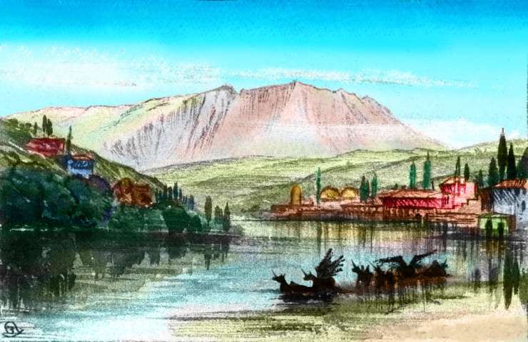
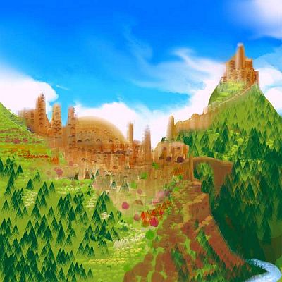
Ride the updraft, glide south. Hundreds of kilometers a day. This land's like an east-coast Chile, but wider, greener, longer. Stone cities stud the highlands like a hundred Machu Picchus. The hillsides surrounding Aviatrican hill-towns have been terraced Inca-style, to provide more farmland to grow crops. However, the architecture of the Aviatrica is airier, lighter than Incan cities, more like Rome or Kush; they long ago mastered the arch. The largest is on the windward flank of Mount Kanwelin: the temple-city of Linnarol, spiritual capital of the Aviatrica.
These highlands were not, though, the original Aviatrican homeland. That lies well to the west, in much hotter lowlands. The highlander subspecies, the Aldiruyo, have dominated for generations, swamping older genetic lines. Still, you may see features hinting at the two older subspecies:
Still, we don't have to cater to uplander bias. The coastal lowlands are lush, and to the west we've passed beyond the desert where the Thim Hills end--we're far enough south now so the inland side of the mountains get some monsoon rains. So, a choice.
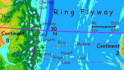
On the COAST: a strip some 1300 km long and 200 wide, a maze of sounds and rugged islands. Jungle down to the beach. Fishing and silviculture--lots of fruit and greens up in the treetops where a human can't reach but an Aviatric can. It's not entirely a sleepy tropical cultural backwater, though the mainstream Aviatrica might call it so; from the largest island, Birdfoot, there's an easy flyway halfway out to Continent 2. Hemispheric bridges like this are rare--this is only one north of the equator. So urgent messages, small, precious cargoes, and just plain folks in a hurry cross here to western Continent 2 and on to Continents 1, 4 and 5. Those with patience (or good sense) go 5000 kilometers south to the longer but safer flyway from Jumpoff.
I said "easy flyway halfway." That's the problem. Volcanic isles every few hundred kilometers lead out to the Mid-Oceanic Ridge. They range from a few to 40 kilometers across--all big enough for woods and fresh water. Ring, the largest, has a substantial lake inside its broad caldera. But the eastern half of the flyway is grim. Plenty of reefs and shallows, but no islets with fresh water, fruit or shade till near Continent 2--and that's a wild desert coast. Here's how it looks from the far side...
I don't care how reckless you are; you're a tourist in rented wings. Forget it--for you, Ring Flyway's fatal in either direction.
So, let's head INLAND and have a look at the savanna that was the Aviatrica's cradle. From Linnarol we loft southwest. There's a pass, but not a hard climb like Linith or Tharlim Pass--here it's an easy, lazy hawk-spiral, for the prevailing winds are with us. Free lunch!
To the west is a broad land of snowless ridges and valleys--the Thar Hills. Arkansas or Ethiopia? Open woods and meadows, clearly less rainy than the coast. But at least not desert.
What's over Them Thar Hills? Let's go see.
Overview - Desert Isle - Temperate North - Eastern Spine - Grecian Gulf - Steamy South - Jumpoff
A day later, a silver gleam: the head of Thoom Gulf, nearly the size of the Mediterranean. We'll be skirting this inland sea for days, heading southwest. We must cross several sounds--arms of the Gulf. None of these passages are more than an hour or two over open water, though. You're tough enough by now not to balk at that. And there are updrafts over the hills and spurs. More than hills, soon; the Coastal Range is bending west to follow us. The land is savanna, with clumps and veins of trees set in grassland. It's hot; we're down to just 15 degrees north.
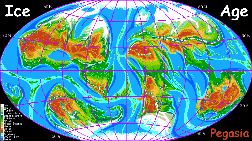
Like the Mediterranean, the Gulf of Thoom was dry just a few million years ago. But not for the same reason! The Mediterranean, though small, is a true sea, the last squashed remnant of the Tethys Sea; Thoom Gulf is extremely shallow, except one underwater canyon. In the last Ice Age (and the next!) it was (and will be again) a desert plain with a Nile-like rivercanyon winding down the middle. That Ice Age desert doesn't stop at the gulf-mouth (rivermouth), but stretches all the way across Inneria, the Gondwana-sized supercontinent dominating the hemisphere during ice ages. As big as two Saharas!
We forget that "Ice Ages" are a term invented by temperate-zone scientists; it'd be fairer, considering its effect on the world as a whole, to call such phases "Dry Ages" or "Tree-Killing Ages". That's as true on Pegasia as on Earth.
This super-Sahara is one reason I designed these tours in a geologic era when sea levels were high. If I allowed an ice age, I anticipated too many tourists dying off. You have enough troubles adjusting to wings, the gravity, the air pressure, the alien cultures. Ice Age Pegasia is so harsh I just didn't have the heart.
Oh the Ice Age is a lovely place, full of the Avia's favorite color contrast, turquoise and red-orange--lovely at least from orbit. But up close, that red-orange isn't so friendly.
So how to explore this long-term-temporary sea? Perhaps we need to visit a port town and meet some sailors. If people here sail. Probably: bulk cargoes can't be shipped by air. And it's a lot safer to sail on Pegasia than on Earth; with a crew that can fly, you're never lost, the weather never catches you by surprise (a weather scout two miles up can see storm-fronts 200 km away) and shipwrecks mainly mean a loss of cargo, ego, and reputation--not of life.
But the mountains snaring sparse rain and the long sounds cooling and breaking up the sere lowlands will make much of the desert livable if not lush. Stony heads and islands--are these indented coasts so different from ancient Greece?
Here people will look to the sea, fishing and/or raising sea crops. Semi-aquatic, though they may still be winged--like diving birds, though possibly six-limbed, giving them one limb-pair for walking and a small set for hands---perhaps folded inside their feathers or fur when diving. Pelicans, ospreys? Flying cats? Griffins? Small dragons? You tell me. Just no "arrrrr", please.
What else am I sure of? Up there on the north shore, land farming is practical only along the occasional permanent stream descending from the Thim Hills or the distant northern mountains. Would those bold, winged coastal divers really stoop (literally: what else do falcons do?) to such a humble, dull, mud-grubbing life? A different species entirely, perhaps--a burrowing, snuffling creature smelling a symphony in the rich soil. Oh no, pig people! Ewww! No, let's retreat into ignorance. I hear it's bliss.
I won't be repetitious and say that phrase again...
Overview - Desert Isle - Temperate North - Eastern Spine - Grecian Gulf - Steamy South - Jumpoff
The south, the south...
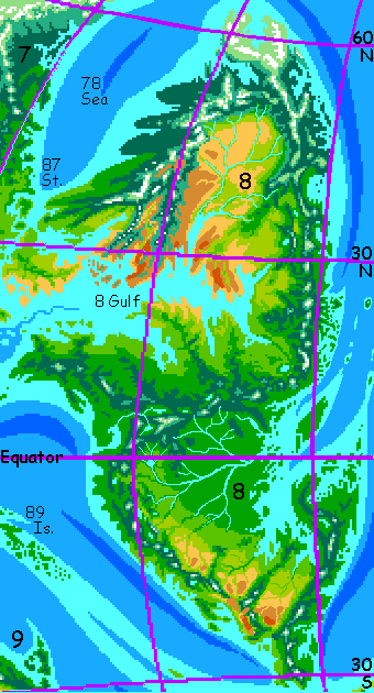
Here's a full-length view of Continent 8, shot from high orbit directly above the equator. Of course, even from several thousand km up there's some distortion. The poor thing suffers from middle-aged, midriff bulge. It's not THAT fat around the equator...
Still, geologically literate readers will immediately suspect from this view that Continent 8 is a Frankenstein monster stitched together out of two lesser continents. North and South clearly collided within the last hundred million years; the scar is the Equatorial Range. Not as severe a collision as India's with Asia (those ain't the Himalayas); but not as old or settled as Europe's with Asia, either; the Equatorials are a lot bigger than the Urals--those white specks on a few of the highest peaks are indeed snow, on the equator. Not a gentle collision--and not quite over!
We fly west along the south shore of the Gulf of Thoom... for a week or more! It's as big as our Mediterranean. But it's at a lower latitude, so here it's the north shore that's in the dry zone; the south shore is greener--in a monsoon belt.
This southland feels quite African--Sahelian?--hot, sunny savanna, with clumps and veins of trees along streams. Not terribly dry, but big, bony, and open compared to the forests of the east coast--or the rainforest to the south over the mountains.
Hmm. I'm tempted to lead you astray. The scenery's monotonous. Maybe we should slip inland and ride the air over those mountains. Still, water's really not a problem on these plains--not for the winged. On foot this'd be hot, dry and tedious. Let's be patient. The local culture may turn out to be interesting. Lowland Aviatrica (Intharuyo), or something else? Don't all say it at once, but... you tell me.
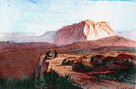
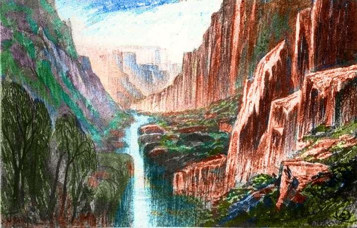
I claimed this shore wasn't too scenic, but the next day we stumble on an exception. Well, not stumble--flap right over the edge of it and nearly fall in. The heavy rains of the summer monsoon have carved some impressive gorges along this shore, and Ssska Gorge (yes, the accent's on the first syllable) is one of the largest. A bit like Northern Australia's Kakadu, but even more vertical, due to Pegasia's low gravity.
Overall, our analogy with the Americas still holds valid: the northern half-continent we just traversed lay well north of the equator and stretched into the Arctic, while this southern half straddles the equator and is mostly tropical, with a quite Amazonian basin in the east and Andean mountains along the west coast.
The biggest difference? We don't have far to go. This southern lobe is blunt; it doesn't extend much beyond 30° south. No Patagonia--in fact, not even a South Africa. The equatorial forest truly dominates.
After a week of westward flight, we near the mouth of Thoom Gulf, where it opens on the Eebok Sea, that tropical lens-shaped sea at the heart of the Inner Hemisphere.
From here, tourists (and locals) can head west along the Sunup Peninsula and the Frolconia Islands to Continent 6 or northwest to Continent 7...
But here we bank and wheel to the left, into the deep rainforest--the heart of Continent 8 rivals the Amazon!
Well, the Congo, anyway--it looks the size of Brazil in those orbital photos, but don't forget that Pegasia's a moon, somewhat smaller than Earth.
Still, the total biomass of this equatorial forest may well rival Amazonia's; in the low gravity, trees here routinely reach 100 meters and can top 120 (nearly 400').
If they have any evolutionary sense, people here will live in the forest canopy, full of light (and food), not on that gloomy, protein-poor floor...
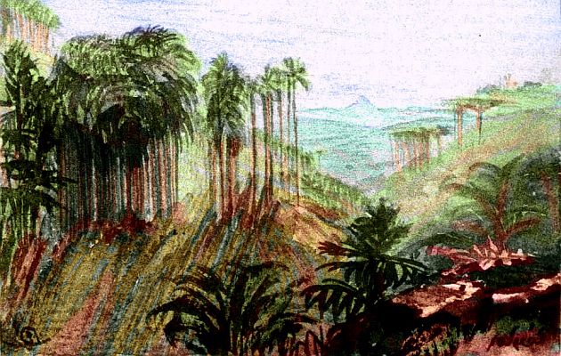
Let's rest and dine as guests in one of their treetop villages. They put on quite a feast, varied and rich... Well, the wiggling grubs may not be your thing, but there are half a dozen treetop fruits and as many more oilseeds and nuts, plus aromatic leaves and shoots for salad.
The only thing missing, really, is root vegetables. Nobody wants to trawl that dark, clammy abyss for those!
The other thing missing from the sketch is your host, since she's still waiting for you to invent her people. Who are they, what do they look like, how do they live, what do they think?
Sing along, now! You tell me.
Another difference from South America: southern Continent 8's west coast is drier than the east, but not nearly as dry at the Atacama Desert. Parts of West Africa may be a better analogy. Storms roll in from the southwest with fair regularity. And these west-coast mountains are both lower and much more broken-up than the Andes, letting some of the eastern rainforest's moisture through. A desert stretch does lie ahead, but it's still days off. Before that is a pleasant strip 2500 km long--open forest, coastal savanna, and lake-filled valleys below occasional snowcapped volcanoes and jagged fault-block ranges like tropical Sierra Nevadas.
After a few days, let's find a gap and climb east over the mountains, to see the savannas south of the rainforest. I'm leading you this way partly to avoid that west-coast desert around 25 south. Down there the prevailing winds blow from inland, and the high mountain-spine wrings most moisture from the descending air. It may not be Namibia or Atacama, but I'd still rather avoid flying you over desert. Besides, I'd feel like we're cheating if we never even venture east of the mountains!
By now we've flown south well past the heart of the eastern rainforest; over the pass, you find broad basins of olive and gold--strips and groves of trees broken up by savanna. Spurs of the mountains are always on the horizon. True, for a flier a kilometer or two up, avoiding the heat of the plain, the horizon is quite a long way off; but creeks from the mountains are always within sight. A few of the peaks ahead bear snow, and many are high enough to trap rain, guaranteeing us drinkable streams all the long way east.
The Pampas? The Chaco? Or will you be forgetting South America and thinking of Malawi or Tanzania?
Continent 8 was never as wide as the Americas, and it's narrowing here in the south. Only takes two or three days (double-size Pegasian days, but still) to cross the continent. Snaky rivers wind north, to your left, where open water gleams: the eastern gulf. Swamps full of oxbows--and megafauna you'll have to describe to me.
How far east should we go? There's a whole green subcontinent ahead. Will it be like Brazil's Northeast--tropical but prone to droughts, unlike the Amazon? I doubt it: this peninsula is open to storms east and west--off both the ocean and the eastern gulf.
I expect rainforest nearly as tall as the Pseudo-Amazon to the northwest, if not quite so dense. Hot, but not as muggy.
This eastern peninsula is rugged land; even here, I spotted snowcaps on a few peaks, and to achieve that in Pegasia's tropics means they must be Kilimanjaros at least. Good! Pleasant respites from the heat for tourists like us, climatic variation for the locals, and these north-south ranges again cross the prevailing winds--while those swing north and south seasonally, they mostly come from the east. As they hit the coastal mountains they generate steady updrafts. Hawk highway!
This eastern peninsula breaks up at the tip, into a gaggle of rugged islands. At least three rival Taiwan. We certainly can't expect Brazilian Northeast droughts up here--we're right on the equator. Rainforest, lush and warm. To the northwest is the leaf-shaped Isle of Z----, bigger than Java.
I don't think we need to go that far--it's all endless jungle hills and swampy deltas. Let's stick to the mainland, following the local flyway south: the maritime slopes of the east coast. It's an easy run of a couple of days to our last stop on the tour...
Overview - Desert Isle - Temperate North - Eastern Spine - Grecian Gulf - Steamy South - Jumpoff
The isolated, rather Mediterranean southern tip of Continent 8 is an interesting land in its own right, an ecological island like California or coastal South Africa. But it's also the doorway--nearly the only doorway--to Continent 9 and the Outer Hemisphere, via the Rift-Junction Islands.
This means the region is only isolated ecologically. Culturally, it has to be quite cosmopolitan. Since the trans-hemispheric flyway was discovered--however long that's been--fliers from around the world will have been passing through, and settling, and mixing. Society here is not just highly multicultural but multispecific. At least one great port city at the southern tip of Continent 8--call it Jumpoff, that's a good translation of its various names--will have no single species in the majority. Not coincidentally, it will be one of the most culturally and scientifically advanced places on Pegasia; and its chief rival, Continent 3's Port Fizrat, anchors the east end of this same 3000-km flyway. Pegasia's London and New York!
But what sort of species, and how many? Last time, I promise! You tell me.
The gazetteer will have a full index of native placenames, with descriptions--once the contests's over and we have natives to name them.
World Dream Bank homepage - Art gallery - New stuff - Introductory sampler, best dreams, best art - On dreamwork - Books
Indexes: Subject - Author - Date - Names - Places - Art media/styles
Titles: A - B - C - D - E - F - G - H - IJ - KL - M - NO - PQ - R - Sa-Sk - Sl-Sz - T - UV - WXYZ
Email: wdreamb@yahoo.com - Catalog of art, books, CDs - Behind the Curtain: FAQs, bio, site map - Kindred sites