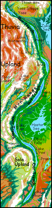
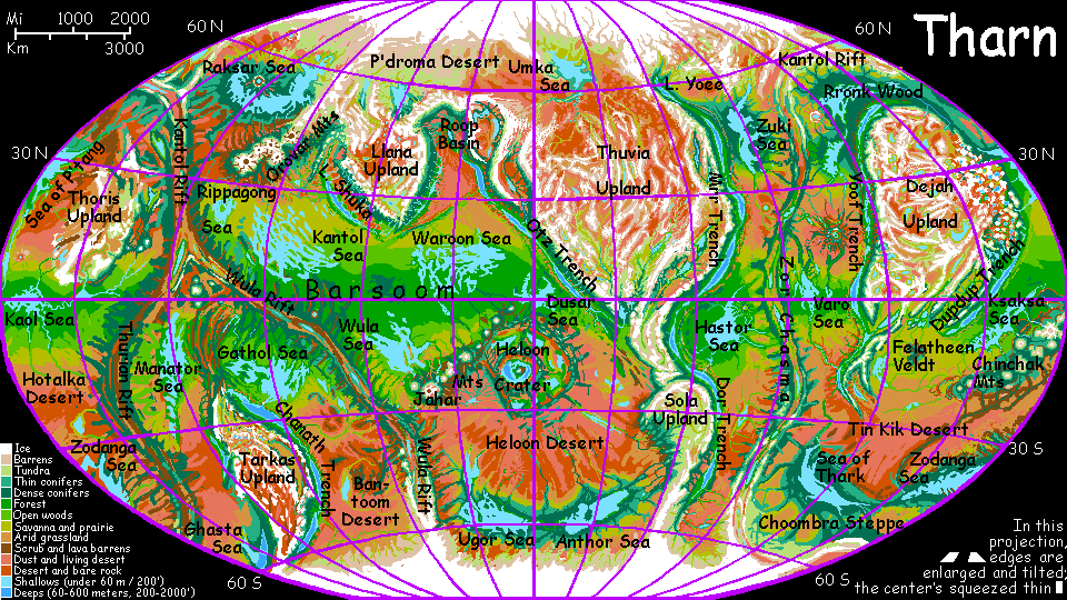
Mrr Trench
by Chris Wayan, 2005-9
For Lady May
Map, Tharn's homepage, Peoples of Tharn, Regional tours, Geology and Evolution, gazetteer, terms explained. More worlds? Planetocopia!
INTRODUCTION
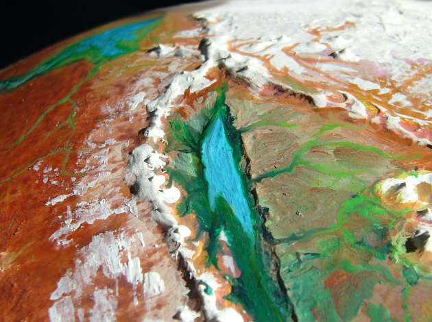
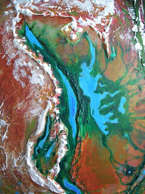
Mrr Trench, east of Thuvia Upland, is the longest trench complex on Tharn, some 10,000 km (6400 mi) and 3-6 km deep (2-4 mi below the plains). It's remarkably like the trenches in our western Pacific, if you removed all the water. Mrr runs south from Lake Yoee to Lake Rree, where it's joined by a small western spur forming the Worawora Basin. Further south, past Lake Au, the trench bends sharply; this hot, humid and relatively shallow curve (in spots, a mere 2500 meters deep--8000') is called Yarr Trench. Beyond the bend, the trench resumes its southward march; this stretch east of Sola Upland is called Dor Trench.
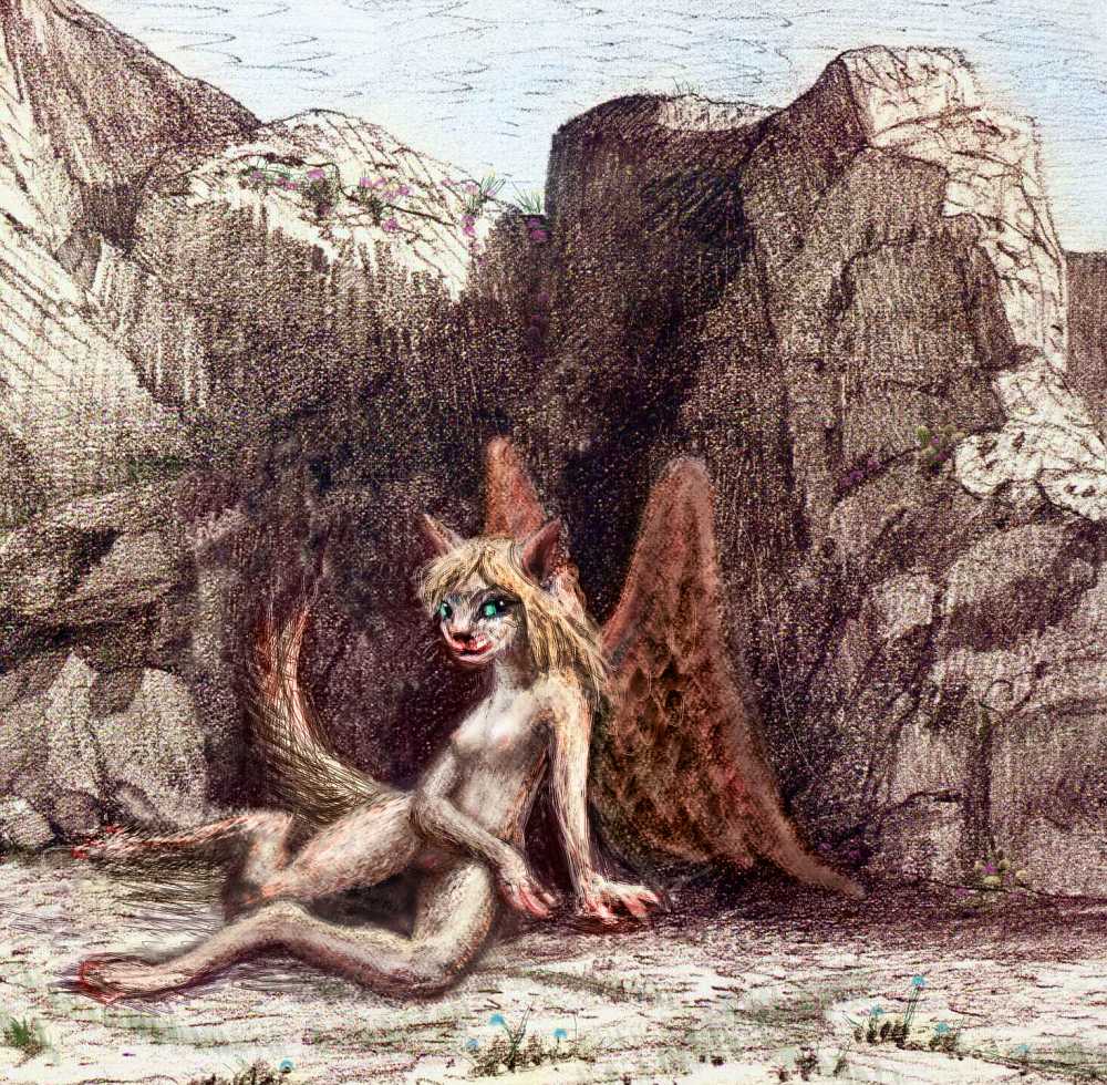
Mrr, Yoee, Worawora, Au and Yarr are just attempts to transliterate the native lebbird names. These elegant winged omnivorous cats tend fruit- and nut-orchards all around the great sunken lakes, but they're simply too heavy to fly in the thin air of the plains 2-3 miles above. Few ever leave, though they're great travelers inside the trench.
Most do speak Trade Camaroo (the worldwide pidgin), but with a thick, throaty purr. But comprehensible; and that's fortunate, for non-lebbirds find the local tongue nearly unlearnable. Lebbird brains seems hardwired to distinguish sounds outsiders can't; and their associations and metaphors weave as crazily as a path along tree-branches.
Day-to-day tours aren't a practical way to explore Tharn's wide plains and uplands. A trek at a true Tharnian pace is too slow--even in this low gravity, natural runners like veltaurs and centahs manage only 200 km per Tharnian day, and camaroo caravans, the usual way to travel, do well to manage 80 (50 mi--25 per Earth day). But trenches are different. The air's twice as dense as on the plains! You can travel as the locals do--by air. So put on your parka, check your oxygen mask, and strap on your wings...
NORTHERN MRR
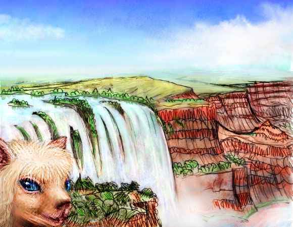
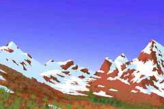
You're standing on a red, dusty plain under a purple Martian sky, under a copper noon sun, shivering in a thin cold wind. But at your feet, Mars just ends. Two miles down, through a gulf of turquoise air, you see dark forests and a glittering, deep blue snake--Lake Yoee, northernmost of the Mrr trenchlakes.
You ready yourself, get a running start, and leap off into the gulf. Air whistles around you. You circle a while, riding the updrafts where sun-heated air rises along the rim-cliffs. Mind the turbulence. The winds are terribly thin up here; without those updrafts you couldn't even stay aloft. The gravity's gentle too--you try a dive, and fall in slow-motion. Feels like a dream, but beware: the drop here is so great, a low-grav fall will kill you just as dead as Earth ever could.
You panic a moment when you find that even with the strong updraft, you can't climb back up to the rim! The air's just too thin. The only way is down.
And down we go... in a long dive, starting slow but soon terrifyingly fast, for there's little air resistance. Fear breaks through to exaltation as you learn how falcons feel.
At first glance, the land below seems a wilderness. But the woods seem curiously colorful and varied for a northern forest in a semiarid climate--so many different trees, each bearing a new fruit or nut. Not by chance: this is one vast orchard!
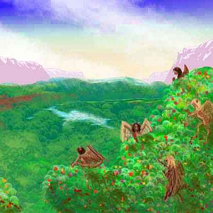
Next you notice holes in a lakeside bluff--a cliff-dwelling. And in that deep bottomland grove beneath you, those aren't giant shelf fungi clinging to the trunks. Too symmetrical, and notice the windows? Treehouses! These are signs of lebbirds--the northernmost of their species.
In minutes the sky pales from a bloody wine-purple to blue, deep but almost Terran. The air thickens, slowing your fall. Red cliffs and bluffs rise in terraces two miles above you; below, meadows with strips of dark evergreens along streams, merging to forest down by the nearing shore.
Pull your mask down if you like; you can breathe here, if you don't overexert. Lake Yoee, 3.2 km (10,500') down, is just the bottom of a bigger, nearly invisible lake: a fingerlake of warm dense air poking into the northern steppes. The trees below you are the northernmost in the world--as out of place as the cats who tend them.
Lake Yoee's quite salty, for evaporation's high and rainfall modest most of the year, here at 60 north; we're nearing the polar desert. The few streams dropping off the plains and the western mountains aren't enough to balance evaporation; the lake survives only because even larger Lake Mwaa feeds it from the south.
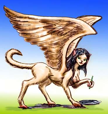
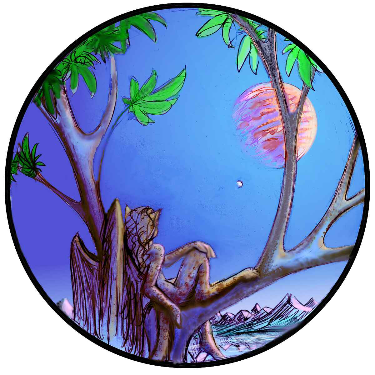
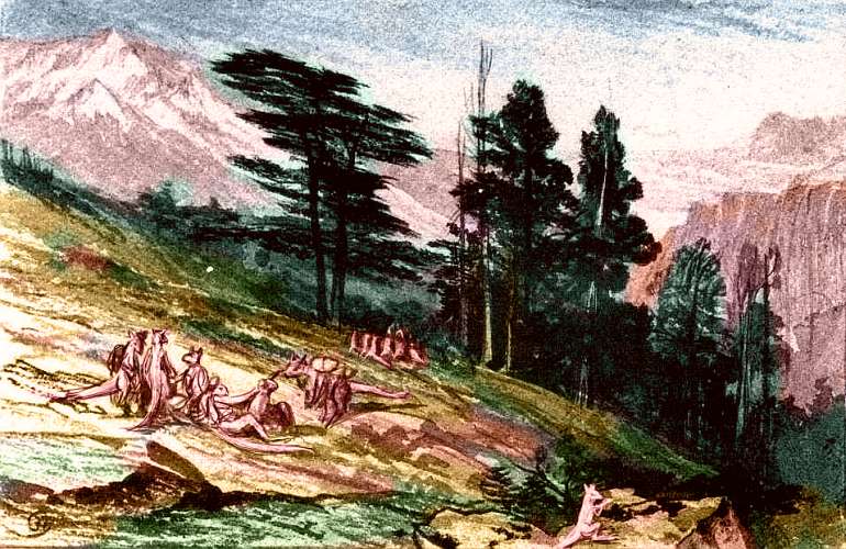
The local lebbirds have far shaggier pelts than their tropical ancestors, looking more like small lions or sphinxes than leopards, as you'll notice of the artist I sketched at the top of this page (while she sketched me; the round object is her sketchpad. Books on Tharn are typically round). Yoee lebbirds need that extra insulation--here in this northern valley, the great walls rise east and west, shortening the hours of direct sun. Much of the time, it's a twilit world.
And Yoee's about the coldest trenchlake on Tharn. 3000 km due east, a similar lake lies deep below the northern plains, but Lake Rrao gets far more sun, for it runs east-west; the north wall of the trench faces the sun all day. Frost is rare there. Still, even here in Yoee, when a Siberian winter grips the plains above, the snows here two miles below are mere stray flurries. When a string of true bone-chilling blizzards does hit (and one does, every generation or so) the locals have a last recourse. They take wing and ride the stormwinds south along the trench! At 95 kph (nearly a mile a minute) a lebbird can migrate out of the snowbelt in a single day.

So, in a single Tharnian day--two sleeps--you leave the great lake behind. A deep, wooded trough marches south. It's noticeably warmer now, and damper; puffy clouds straggle over the azure sky. At midnight, a light rain. Snowy mountains loom to the west, mesas and bluffs to the east.
By dawn the next day, silver gleams ahead: Lake Mwaa. Far warmer and larger than Yoee, fully 1100 km long and up to 130 wide (690 by 80 mi), Lake Mwaa is "only" 2.8 km below datum (9200' down); it drains north to Yoee. Its shores and the slopes above are heavily forested, for Lake Mwaa stretches from 52 to 37 N--right across the rainy temperate zone. The rain has filled the trench floor much deeper than shallow, salty Yoee; it's why the lake surface is 400 m higher (1300'). On average, the trench itself is no shallower.

In this milder, rainier climate, the trees grow gigantic, rivaling Earth's redwoods; stout enough to support lebbird treehouses. Every village is high in the trees, not just those on riverbottoms as in Yoee. Though lebbirds like fish, they prefer living treehouses to shoreside cliffdwellings; those low, rounded huts out on coastal bluffs are thotter villages--a flightless, semiaquatic people.
It's a good two Tharnian days--four sleeps, a hundred hours--to the subtropical south end of Mwaa. You follow the Mwaa River south. The next morning, you glide over tall forest; but after the siesta, the woods slowly thin and patchy meadows open. The trees clinging to the eastern cliffs and terraces grow scruffy and thin.
You're flying out of the temperate zone, into a Mediterranean belt. The sky's a cloudless blue, the palest you've seen on Tharn. Flying (and breathing) seem easier. It's not just that you're getting in shape--for 100 km south of Mwaa's tip, the trench floor rose slightly, but now it's gradually deepening. The air's almost Terran now, fully as dense as in Lhasa or Cuzco. Enjoy!
You camp on the beach of a small lake for the long sleep. The next morning, as the sun's clearing the eastern cliffs, pale blue gleams ahead--the northern tip of Lake Rree. This is a decision-point in your tour. To the west, the Worawora Valley leads up into the mountains; just outside a lebbird town on the mouth of the Worawora, a great caravan is lining up and heading upriver. Where are they going? Should you follow? One ominous sign: in this lebbird-dominated trench, the caravan has not one lebbird... why?
WORAWORA
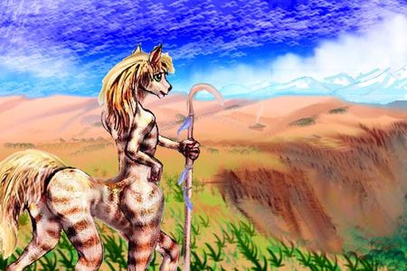
Over the Mrr Mountains west of the Trench lies the fertilest arc basins on Tharn. Not that that's saying much--with high mountains cutting off storms all around, most such basins are desert or steppe. But the Worawora Basin has wide prairies and wooded streams descending from the Mrr and Worawora Ranges cupping it east and west. There's enough water to support centahs' flocks, and forest-dwelling mops by the lakes; it's even warm enough for a few veltaurs (sketch to left). To these nonfliers, Worawora is a warm, fertile, cultured oasis, compared to the harsh Thuvia Uplands around it.
But to the few lebbirds who live here, (mostly traders, eccentrics and a few religious cults wanting isolation) even the long green shores of Lake Worawora, 1.9 km below datum (6,250' down), are just a thin-aired frontier, the very edge of the livable world--a mere whisker-tip of the rich lebbird heartland to the east in Mrr Trench.
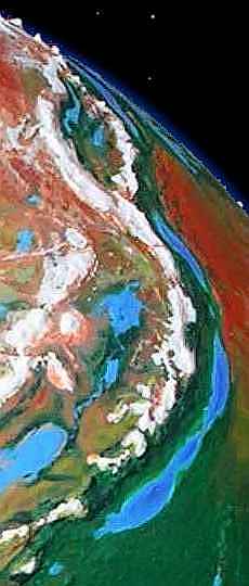
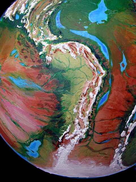
Lake Rru, the smaller lake in the eastern Worawora Basin, is barely a kilometer below bedlevel, and has no resident lebbirds; flight's just too hard there. Centahs herd their flocks around the lake, just as camaroos do in the cooler hills above. It's scarcely a trench at all; what it resembles most is the Foori Arc-Basin, 1000 km to the south, which is well above bedlevel and thus part of the Thuvia Upland tour. It's in the left foreground in this orbital photo; Worawora is at the top. Curiously, these two basins have similar climates--the huge altitude difference nearly cancels the equally big latitude difference!
The Worawora camaroos probably arrived over high mountain passes from the shores of Lake Kitlei, due south (uppermost of the three lakes in Foori Basin visible in the photo). Camaroos could breathe the stratospheric air of the Worawora Knot, but all the other species had find lower passes through the Mrr Range to get here; the lowest pass climbs from the north end of Lake Rree on the Mrr Trench floor (bordering the desert on right), and rises to nearly 2 km above bedlevel, then down into the south end of Worawora Basin. The route is rugged, climbing over 6 km (20,000'), then dropping half that, a mere 10,000' into Worawora. No lebbird can fly more than halfway up the pass, and few can even hike to the summit (air that high and thin makes them faint). But riding pack animals in a camaroo caravan, gasping and helpless among the baggage, they can make it alive. A grim voyage, but easier than crossing Trunzip Pass to the south, equally high and much longer; there, lebbirds face a (slight) risk of brain damage.
Of course, even the Tharnian surface poses not-so-slight risk for a Terran, and Worawora Pass would kill you. But you still have your oxygen mask, right? So I guess we could detour into Worawora. But on foot; if a native lebbird can't fly there, you sure can't. It'd be a long slow hike. On the wing, a loop round Worawora Basin would take over three Tharnian days--a Terran week. On foot, make that one or two months! Over marginal land. In thin air...
Inclined to say no? Now you know how lebbirds feel. The ease and speed of flight motivates them to stay in the deeps. Human explorers who headed off the map didn't suddenly find themselves crippled by atmospheric physics! Deserts, jungles, polar ice: all had their dangers, but you could still breathe. The consequences for the lebbirds have been serious: they're limited to barely 1% of Tharn. Some other trench-born species (notably elaffes) have crept up and out onto the plains, slowly adapting to the thin air; but elaffes are flightless. Lebbirds can't bear to be grounded; and can you blame them?
So let's omit Worawora and stick to your wings.
SOUTHERN MRR
Lake Rree is one of the smaller Mrr Lakes, a mere 500 km long (300 mi), filling the trench floor from 28 to 22 north. Rree has never seen snow, and never will. It's a warm dry latitude; trees only line the lakeshore and the mountain streams on the west side, and the slopes are often bare cliffs of red and black. Rree is a salt lake with no outlet but evaporation.
Old hands on Tharn will notice many parallels between Mrr Trench and Yoof Trench to the east; it too crosses this dry zone and has a small, salty lake at this latitude. But Yoof's Lake Hoom is lower, saltier, and hotter; its shores have no trees away from creeks and irrigated orchards. Why is Rree basically Southern Californian in climate and Hoom nearly Saharan? Because at this latitude, the few storms generally blow east to west; it's why nearly all the desert coasts on Earth are on the west sides of continents around 30 north, with prevailing winds blowing off inland deserts. Here on Tharn, Yoof Trench's winds usually blow east, off cold dry Dejah Upland; few storms off the Wolak Sea to the west can reach Lake Hoom. But here in Mrr Trench, more frequent storms off the Zuki and Hastor Seas to the east can bring modest rain.
Both trenches benefit from a mild monsoon effect during orbital summer, when the alpine pastures of Dejah and Thuvia warm up, pulling moist sea-winds over the trenches for several months; but Rree's dry season is shorter and its annual rainfall is double Hoom's.
Still, it's dry. But "even blue skies have a silver lining"--the long annual drought means Lake Rree fills only the very bottom of the trench.
The lakeshore's fully 4.5 km down, making Rree the lowest lake in the north, with the densest air. Temperature fluctuations and ultraviolet are minimal; Ree's a surprisingly kind desert, all that Southern California promises, and more.
That unusually dense air lets fliers grow larger and heavier than elsewhere: flyotes, that ubiquitous species, here grow so big they're unquestionably people; on the thin-aired plains above, the average flyote weighs half as much, with a brainsize (and behavior) disturbingly midway between animal and human.
The lebbirds, too, run tall here, though leggy--slender as ballerinas, the better to radiate heat. Their pelts are short, no more than velvet, and their ears large and pointed.
This may not be a local subspecies but the original breed--lebbirds may have evolved here, as fishers along these dry shores. Only after the invention of silviculture did the lebbird heartland shift to greener Lake Au to the south and Mwaa to the north--though the lebbirds of Mwaa insist their lake is the species' ancestral home.
Fossils don't help; none older than 6,000 years have been found in either locale, for lebbird bones don't last well. Fliers' skeletons are just too light and delicate to survive in any numbers. No massive, heavy-browed skulls here! Every ounce of bone meant a lost ounce of brain... lebbirds are that close to the weight-limit.

In any case, modern Rreean lebbirds are mostly farmers, living in irrigated nut groves fed by snowmelt creeks on the west shore. Nowadays few lebbirds anywhere fish except for fun, since thotter fish-farms are more efficient; in peaceable modern times, as thotters have spread, it's become cheaper to trade tree-products with them. The two species live intertwined--most thotter villages, too, are on the west shore by creek-mouths, since they like fresh water and Rree is salt.
The east shore's creeks are few and small, draining desert fossae--deep, straight canyons carved not by water but cracked open, as dry crust bends downward into the trench. Long mesas rise in ranks, with north-south fossae between them. Streams break through these walls only rarely, in breathtakingly narrow canyons--stone cathedrals of flood-carved rock.
In these canyons live the other winged species, the cliffdwelling flyotes. They favor natural overhangs and caves, enlarging them slowly. Flyotes like a view. They commute on the wing to work, irrigating small fields on the canyon floors--not the domesticated trees common elsewhere (sporadic but torrential thunderstorm-floods from the fossae upstream devastate streamside woodlands), but annuals, mostly seed- and fruit- bushes plus a sweet, starchy reed-thistle. It looks remarkably like the corn-bean-squash-tomato farming of canyon tribes in Arizona. Even the cuisine is similar. Like Terran canines, flyotes are about fifty percent nose. They like strong flavors--this is smoky, spicy cooking, with dozens of aromatic herbs, heavy on beanlike proteins and nut-butters. Flyotes are meat-loving omnivores, originally hunter-gatherers, and they like a solid meal...
It's a little challenging for an amateur flier like you to try crossing the lake on the wing, but if you're not up to it, thotter boats sail across regularly to trade; it's well worth a side trip just to see the canyons and caves, sample the cuisine in a cliffside cafe, and enjoy the singing--flyotes do love a howl.
Away from the lake, this maze of cracks continues, but the fossae floors grow higher, the cliffs shorter; the cracks ramp up to the high featureless plain of the Zu Desert, where the air's too thin to support lebbirds. You'll still find a few flyotes up there, but in response to the thin air they're small and simpleminded. Flight and brains grow mutually exclusive--and, tragically, flyotes are just too adaptable to draw a sharp line, as the (larger) lebbirds do.
Lake Rree takes only one long Tharnian day to pass--it's barely bigger than Lake Michigan. A river pours into the south end: the Au (pronounced with a rising tone: "Ow?"). The river rises too: the trench has bottomed out. As you wing south the next morning, the river's a green artery through a swath of savanna. After the noon siesta, you notice more trees, more clouds ahead; you're leaving the dry zone. Also, that silver sheen ahead is the largest single lake in Mrr Trench; it makes its own weather!
LAKE AU
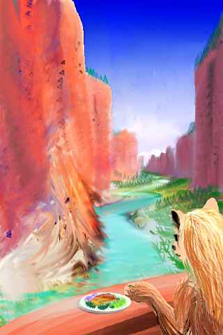
Lake Au is huge, nearly 2000 km long, stretching from 0-18 degrees north. It's much rainier than Lake Rree--just as lush as Lake Mwaa a thousand miles north. We're far from the temperate zone now, well into the tropics. Here at Au's north end, the heavy rains come in orbital summer, in savage thunderstorms on those day-long afternoons, though light rains fall year-round. The shores look jungly; actually, they're carefully tended lebbird orchards. For today, Au is the lebbird cultural heartland.
Days here are hot--not quite the hottest place on Tharn, but close. After all, we're near the equator and 4 km below the plains; the dense air acts as a greenhouse doubling the heat. In orbital summer it can reach 315 K (42 C, 108 F) in the shade--fortunately there's a lot of that, and water, too, for a belt of rising equatorial air generates year-round rains feeding a lush, hothouse forest. It'd be even hotter without all those trees transpiring... though perhaps not as humid. Get used to flying in the shade of the cliffs, and dawn and dusk flights.
Take care, though. The air's crowded with flitting silhouettes, like rush hour in Earth's great cities. Without headlights. And it's a long way to fall. Low gravity is a two-edged sword; if you slip, you have more time to recover, and you can fall further and survive; but low gravity also means these trees grow much taller than Amazonian rainforest; some are taller than any Terran redwood.
Lebbirds here sleep while the sun's high. Since the trench walls loom east and west, hours of direct sun are shortened a bit; it's a land with long dawns and dusks. At night the cities of Au come alive, under the vast golden glow of Zeus, Tharn's primary, a gas giant twice Jupiter's mass. In the sketch below, the small white moon is Pegasia, larger and biologically richer than Tharn--Earthlike, in fact, if not quite Earth-sized. Together their brilliant, warm light outshines our dead little moon a thousand times; even a diurnal animal like you would see full color at midnight! And on nights when Zeus is down, out come the oil-nut lamps, and every tree glows with the firefly lights of music-inns and berry-pubs. The tree-towns of Au are like Dunsany, Yeats or Tolkien's visions of Elfland: a luminous twilit world--if you substitute skinny little winged leopards for elves.
The music's not bad, either.
YARR TRENCH
Yarr is an arcuate trench between Thuvia and Sola Uplands, linking Mrr Trench in the north and Dor in the south; they're all parts of one huge subduction zone. If Yarr and the Molak Range above them were on Earth, the complex would be an island arc with an associated trench, much like the arc linking Patagonia with Antarctica. That sudden bend is where a stubborn line of mountains refused to move along with the rest of the South American plate; like a ship's bow in water, they caused a shockwave of ridges behind them and a trench at their feet. Yarr is a strange bend, though. Unlike our Atlantic coasts, which fit together so suspiciously well that they inspired the theory of plate tectonics, these trenches and "coasts" of Yarr and Yoof Trenches just don't match; there's a rounded gap. Very suggestive! The Yarr bend may be the western half (and Wrr Basin the eastern half) of a great circular lowland, perhaps an ancient impact basin, split apart 300 million years ago.
Whatever the origins of the Yarr curve, Tharnians aren't complaining. Instead of another million square miles of harsh highland (just what this planet needs!) the great bend lengthens the fertile oasis of the trench, and even up on the bedlevel it makes room for a great tongue of lush rainforest west of the Hastor Sea called Invak Wood. The plain bows upward and ends in low hills near Yarr Trench, preventing any great rivers from draining down into the trench. Despite short feeder streams from those hills, Lake Yarr runs as deep as 900 meters (3000') in spots--extraordinary for Tharn. Blame those steady equatorial rains. Because the lake's so deep, its shores are a mere 2.5 km (8000') down. The (relatively) dense air holds moisture, and the climate's steamy; the slopes of the trench are a lush rainforest hotter than any on Earth.
Still, air pressure is relative. While the bos of Invak Wood find Lake Yarr a high-pressure steambath, air a mere 8000' down is relatively thin for the native lebbirds; they evolved in trenches 4-6 km (13-20,000') below the plains! The combination of equatorial heat and relative thin air around Lake Yarr has made the local lebbirds as small as those around Au or Rree: slender and long-limbed, with short pelts and big foxlike ears to radiate heat. The lower weight eases flight--or rather makes it possible. Lebbirds, like all winged peoples on Tharn, are ponderous fliers with small safety margins: the evolutionary pressure to enlarge the brain clashes with the aeronautical need to keep the weight down. It's such a narrow balance permitting both intelligence and flight! If Tharn's air had been thicker or thinner we'd find either a world of all fliers or all walkers, and the trenches wouldn't matter. As it is, Tharn's two worlds in one.
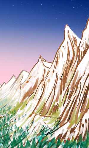
To the west of the lake and trench is another world--the Yarr Mountains, the gigantic front range of Molak Upland. They're as high as the Andes, 5-7 km (16-23,000'), but up to 9500 m (31,500') tall as seen from the trench--taller than the Himalayas. Less snowy, being equatorial, but steeper, due to Tharn's low gravity. Cliffs and crags abound. A spectacular region no tourist should miss!
Humans tend to assume that mountains (especially ones as savagely vertical as these) are backward and thinly inhabited, even wilderness. Logical for ground-dwellers--but wrong here. Those dots of light on the crags are sky reflecting off the round windows of lebbird and flyote cliff-dwellings. The front range is densely populated. Why? Prevailing winds blow into the Yarr Range, creating steady updrafts; it's blessed with a natural transit-system offering free rides for 2000 km... if you have wings.
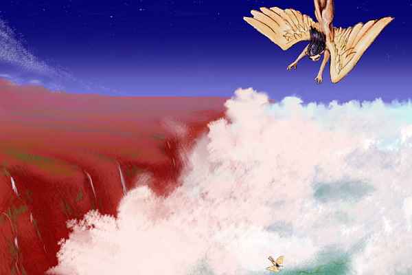
LAKE L'REE and OBARA FALLS
The Hastor Sea, east of Yarr Trench, is really a freshwater lake, for it has an outlet: the Obara River, draining down into Lake L'ree in Dor Trench. The river's a chain of great cataracts, over a dozen major ones. The highest is a sheer fall nearly a kilometer high (3200') and 1.6 km wide (a mile), and two others fall nearly 500 m each, for the Obara drops 3.3 km in 65 km (11,000' in 40 mi). Nor are these mere plumes like Angel or Yosemite Falls; the Obara is larger than Niagara! The Hastor Basin isn't as big, hot or wet as the Amazon, but it's rainy for Tharn, and this is its sole outlet.
It makes for great scenery, but it's an ecologically dangerous situation, for such a large flow could fill the trench, destroying the falls and creating a birdsea sequestering much of Tharn's water. Three things prevented this: Hastor, though rainy, is still a Tharnian bedlake, with an air pressure only a quarter that on Earth's surface; evaporation is swift. Lake L'ree is much lower, but hotter, too, and in a sunny, high-evaporation zone. And L'ree has a safety valve; it spills over into Lake Hhurr to the south, in a warm, sunny, dry zone. The three lakes and their long linking rivers manage to evaporate as much water as the rainfall they collect. Still, the falls have filled L'ree over 1 km deep in spots, and it averages 400 meters: deep for this dry world. And even 3.3 km down is a high tide of sorts: 4-6 km down is more typical of Mrr Trench.
The western shore of Lake L'ree is a great crossroads. Above, to the west, lies Trunzip Pass, the lowest pass to the Barsoom Basin and Heloon Crater, the biological heart of Tharn. The pass is the only practical route avoiding Thuvia and Sola Uplands. Trunzip is still 3.2 km (2 mi) high, a narrow, avalanche-prone valley between the high Molak and Sola Ranges, but the valley floor is snow-free most summers, and more to the point, has air thick enough not to (usually) kill or brain-damage trench species like lebbirds and wingbok, allowing caravans to carry them (even if they can't walk) between hemispheres. Trunzip is Tharn's Panama, Gibraltar, Suez, Malacca Strait, and Chunnel all in one.
DOR TRENCH
Where does Yarr Trench end and Dor begin? They're just names; the great curve reverses over the next couple of days, as you skim past the southern tip of Lake Yarr, over a steamy jungle trough, then along another, wider lake: L'ree, a good 1300 km (800 mi) long.
My opinion: you're leaving Yarr Trench halfway down Lake L'ree when you hear an unbelievable roar ahead. It's the last of the Obara Cascades--a 200-meter fall, like four Niagaras... South of the falls, the air is slightly cooler and steadily less humid. You're leaving the tropics and entering a drier belt. To the west, the Dor Range looks geologically identical to the Yarrs, a jagged wall 10-12 km tall (33-40,000'), though "only" 6-8 km (4-5 mi) above datum, since we're nearly 4 km below. But instead of basins and ranges behind that high front, there's a vast plateau, the Sola Upland. Slipping cold air down its slopes, Sola cools the trench's stifling floor by forcing its greenhoused air up into thunderheads. These drop rain on the Dor slopes, but not much beyond; even the sky over the east side of the trench is usually cloudless, and the high plains to the east are dry savanna--and getting drier with every mile south. Southern Lake L'ree is mostly irrigation country, like Lake Rree so far to the north.
Beyond the end of L'ree lie a full Tharnian day of easy flight (these treeless eastern walls generate thermals all day) over a valley looking steadily more like a dry East African rift than the jungle trough just a few days back. With no lakes to fill it, the trench seems deeper; the floor is as far as 6 km below datum (20,000' down!) The only trees here--and lebbirds--are along the creeks entering the rift from the western mountains.
But along this this dry lakeless stretch of trench, lebbirds aren't the only inhabitants--ground-dwelling species who can tolerate the heat are common, particularly veltaurs. Lebbirds aren't even the only fliers. Big-brained flyotes dominate the region, tending irrigated fields and small orchards (nothing to support the weight of a lebbird, but still fruit-yielding) below their cliffside burrows.
Since this stretch of trench is so deep, with dense air blocking ultraviolet and capable of holding more moisture, you'd expect it to be the garden spot of Mrr. Yet it's desert, except for the flyote orchards. And this isn't chance; you'll see this pattern all over Tharn. Deep trench, ideal air pressure... desert. Do the geological gods have a mean sense of irony? Well, yes, in a way. Rainier regions half-fill their trenches with sediment and flood them with larger lakes. Dry zones still partly fill with wind-blown dust, but you see the trench at something more like its true depth. Something like! On a Tharn without erosion, trenches might run ten km deep. But Tharn, like all living worlds, is dusty and dirty and complex. And so the geology gods have decreed: "You can have rain, or you can have rich air; but not both."
As always with gods, there's an escape clause: craters! They don't play by the rules. Heloon Basin has half-filled with dust and sediment, like everywhere else; but this impact basin started out over 12 km deep (over 40,000'). The result: a wide basin 7 km deep with a fair amount of rain. No wonder it's Tharn's cultural and population center!
The next morning, as you sail on, riding the thermals (a side benefit of the dry heat of this desert stretch) the long dry zone starts to end. Yellow grass, olive green veins where creeks meander. A little cooler than the dry zone, but still not muggy like Yarr. Refreshing. Lake Hhurr gleams pale ahead--a small, salty lake only 500 km (300 mi) long, but a full 5.5 km below datum (18,000' down). The climate's Mediterranean and the dense air's ideal for flight, so lebbird villages again dot the shore, wherever drinkable creeks descend, while flyote cliffdwellings dot the canyon walls upstream.
Over the next day, as we glide south, trees increase, and the cumulus rising into thunderheads over Sola Upland spread; it could almost be a warm-temperate Terran canyon now, if the walls weren't over three miles high.
A great river feeds the south end of Hhur: the Iss. It's a cold, silty, many-branched stream draining the Proom Steppe and Iss Tundra. Yes, the scorching desert plains above have turned to windy, cold steppes--so cold Tharnians have another name for it, one I've translated "tundra". It's not really (there's no true permafrost, for that's a relic of our Ice Ages, and Tharn lacks that particular illness) but these plains stay frozen over half the year.
Though it's cooled off down here in the trench, it's still so mild you barely noticed how far down the snowline's crept on the Dor Range. In orbital winter, even the cliff-faces turn snowy--a Mondrian of white ledges and chutes on red walls. Even the floor gets occasional frosts. Instead of lebbirds, you see more and more shaggy, flightless mops.
Spearlike evergreens take over from orchards; some groves of these formidable trees are so tall their tops harvest water from the clouds. They don't feel as friendly as the tropical mega-forests; single-minded in their blind growth toward the sky. And their vegetable monomania pays off: the tallest approach 140 m (460').
By the next day, deep into the temperate zone, there's a somber, slightly anxious feeling to the land, and not only from the dark groves of giants along the riverbanks: you're not just in an air-pressure oasis now, but a temperature-oasis, too. Suddenly you recall where you felt this last: in the fragile oasis of Lake Yoee, where we began.
 This too is a pool of life in a Martian steppe. Ecologically, the far ends of Mrr Trench meet. Full circle!
Lesser gorges cut east into the plateau, as big as Grand Canyon, cut by snowfed tributaries of the Iss.
As the trench-floor slowly rises, the trees shrink and thin out. The air does, too. A lebbird could climb a bit higher up the Iss on the wing, but only one more day; and for you, a far weaker flier, this is the end. The edge of the air-oasis. You could hike on--the trench takes nearly a thousand km (600 mi) to dwindle to a mere river-valley in the tundra. But you're long flight's over.
You don't mind. In the last few weeks, as you flew two-thirds of the way from pole to pole under your own muscle power, you've learned a little of what it's like to be a lebbird--or a migrating arctic tern. To the winged, how small a world can seem!
Of course, Tharn is. How small? Well... sell Earth to a developer, subdivide it... and you'd make a huge profit. You could build four Tharns, each with nearly two-thirds the diameter of Earth and five-twelfths the surface area, for a collective total of 1.7 times Earth's surface--and that'd balloon to 5.8 times Earth's land area, if you turn them into Tharns by exporting all that pesky water. (Try Mars and Venus; one of them's bound to be buying.) Tharn looks big and feels big; but Earth's a giant. Four Tharns!

Only... will these warmer Marses hold their air, over the long haul? Or have you just built cheap planetoid tract homes, "little boxes made of ticky-tacky"? Mars is only one-ninth the mass of Earth--just a battered rock, really. The roof leaks air.
Despite appearances and size, Tharn and Earth are much closer kin. For tectonically, culturally, and biologically, they're both very much alive--and built to last. Even if Tharn cooled or lost more air, it's too jagged to die: life would just retreat from the uplands to the bedlands. If and when those become uninhabitable, there are the trenches and craters. A billion or two years from now, I'd bet both Earth and Tharn will still be biospheres despite the slow warming of their suns (inevitable in middle-aged stars). But Earth may be very sick indeed; land life could be limited to a few small highlands and the poles.
But Tharn? Tharn will look scruffier than ever--polar caps shrunk, trenches flooded, fliers extinct, bedlands hot, and uplands mild, so life may have had to move a few km upwards--but overall, Tharn will be scraping by, as always.
Poverty builds resilience? Is that the really Tharn's lesson? Sure wasn't intentional.
World Dream Bank homepage - Art gallery - New stuff - Introductory sampler, best dreams, best art - On dreamwork - Books
Indexes: Subject - Author - Date - Names - Places - Art media/styles
Titles: A - B - C - D - E - F - G - H - IJ - KL - M - NO - PQ - R - Sa-Sk - Sl-Sz - T - UV - WXYZ
Email: wdreamb@yahoo.com - Catalog of art, books, CDs - Behind the Curtain: FAQs, bio, site map - Kindred sites