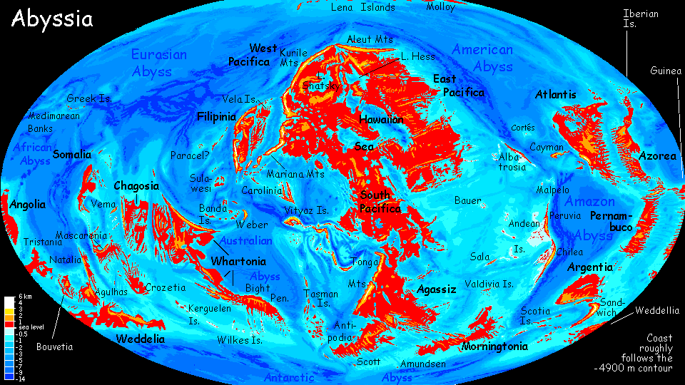
Abyssia:
Filipinia
UNDER CONSTRUCTION!
by Chris Wayan, 2004-17
for Yirko and Bernie
Abyssia home - down to map - building Abyssia - geology & geography - critters & cultures - the clash of names - more worlds? Planetocopia!
Abyssia:
Filipinia
UNDER CONSTRUCTION!
by Chris Wayan, 2004-17
for Yirko and Bernie
Abyssia home - down to map - building Abyssia - geology & geography - critters & cultures - the clash of names - more worlds? Planetocopia!
Introduction - Climates - Western Is. - Vela - Mariana Is. - Peoples
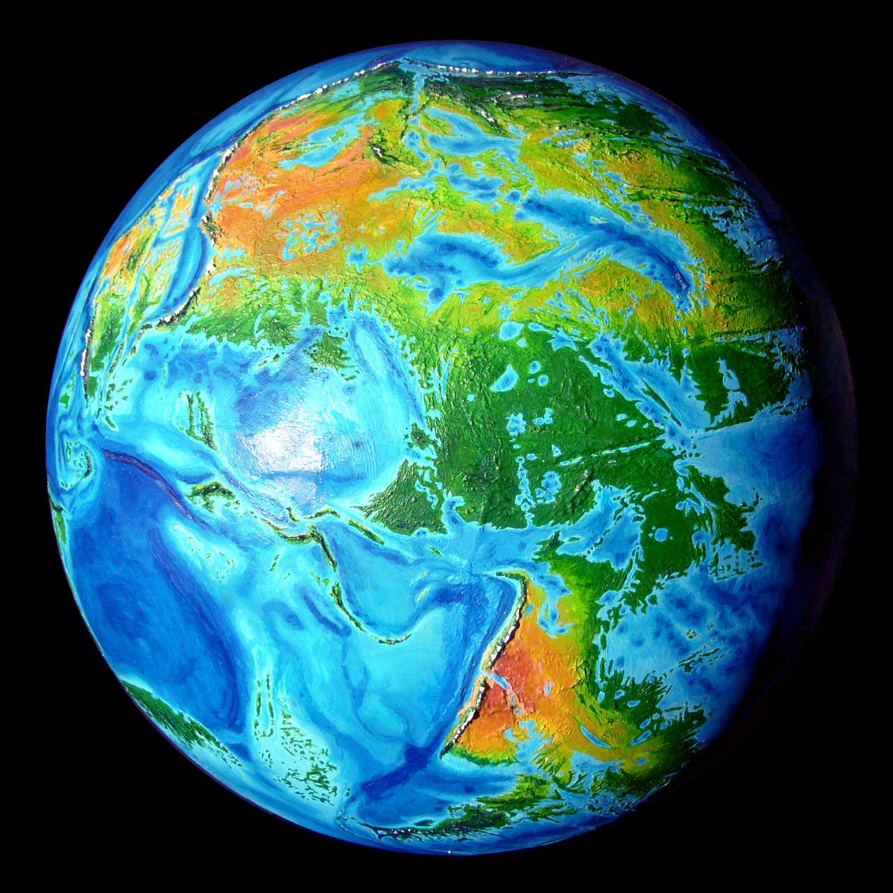
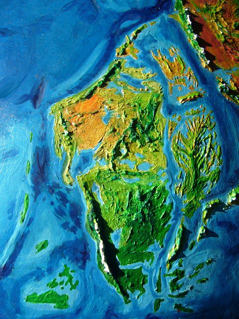
Filipinia is a small continent or large island (2.5M sq km or one million sq mi; bigger than Greenland, the size of the eastern USA). It rises just east of our Philippines--which, here on Abyssia, are just a broad, deep trough.
No loss, though! Filipinia is ten times the size of our Philippine archipelago. True, the climate's not as lush--the deserts of southwest Pacifica and the Mariana Mountains, the highest in the world, lie just upwind, stealing much of Filipinia's rain. The northern Mariana peaks are visible to the upper right on the orbital photo.
Filipinia's terrain is something like a miniature USA: the east is a wide plain with scattered hilly ranges, mostly long Appalachian ridges one or two km high (3-7000'); the west grows drier, than rises to one of the highest mountain ranges on Abyssia, with peaks up to 5600 meters (18,400').
And that's only their height above sea level; they rise from offshore trenches another 5-8 km deep (17-27,000'). Measured head to toe they're taller than the Marianas, 50% taller than Everest. Still, that's only waist-high to Mt Olympus on Mars. With trivial modifications, Abyssia is Earth, with Earth's high gravity; 10-15 km seems to be about as much vertical displacement as our crust can take. But this isn't the world record: that's on the long Isle of Chilea, where the Andes Range tops out at 3.2 km high (10,500'); the Andes Trench offshore is as much as 11.5 km deep. So the Andes, head to toe, reach 14.7 km; again, about half Olympus.
Remember that since Abyssia is just Earth with a minus sign, this is true of our Andes too. They're taller than the Himalayas--by far! Just waist-deep...
And the fact that Filipinia is a close second tells you it's a land under tremendous tectonic pressure. Volcanoes, quakes and tsunamis are common.
Whoever lives here, they won't build cathedrals. Or anything much, right down at the waterline. Once a generation, it all gets washed away.
Intro - Regions & Climates - Western Is. - Vela - Marianas - Peoples
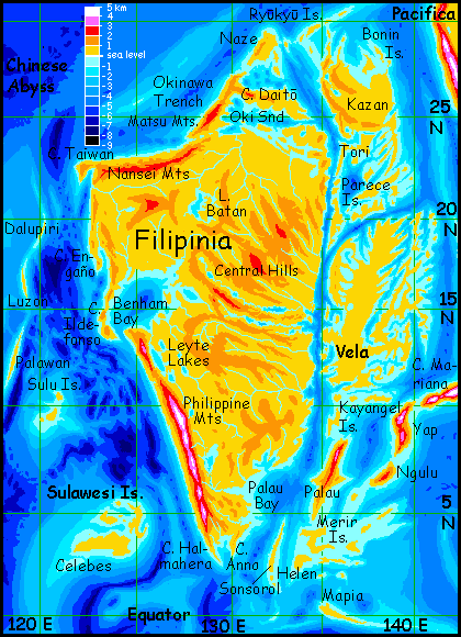
The far north--Kazan, Cape Okinawa and Daito Bay, is at the latitude of our Canary Islands, and like them the region is offshore of a great desert--but far enough offshore, and with the highest mountains in the world blocking dry winds off it. These coasts will be semiarid, but perhaps more like Los Angeles than Cairo--gentle winter rains and a few intense summer thundershowers, but mostly mild and sunny: classic Mediterranean! If the summer gets too hot, you can retreat to the pine-clad Black Hills in south Kazan or the Koho Range on its west coast, both about 1.5 km high (5000'), or the Matsu Mountains on the Daito Peninsula, 2 km high. These even get some snow in winter.
Much of the west coast of Filipinia is dry; the prevailing winds are off the land, not the sea, and rarely bring rains. It's not as extreme as the Bolivian Andes and the Atacama Desert--the Nansei Coast gets fogs along the shore, and gentle rains in winter--but the latitude and landforms are similar. The fishing is comparable too: in most years those seaward winds blow surface water offshore, causing deep water rich in nutrients to upwell, creating some of the richest fishing in the world--and that's saying a lot on Abyssia, with its vast teeming coral reefs. Fishing villages will thrive--though only at the mouths of perennial creeks, snowmelt-fed. Yes, snow again--the Nansei Mountains are up to 2500 m high (8200'), and accumulate deep winter snowpacks. Irrigating these sunny coastal valleys will yield rich crops.
But climb through the Nansei Range to the inland plains around Lake Batan and you're in a very different climate--warm dry winters, with short but savage rains in the scorching summer. Most summers. As sharp a contrast as driving inland from Los Angeles over the mountains into the desert! Though central Filipinia's not as dry as our Mohave, for it does get significant rain, drawn from the narrow seas to the southeast and northeast, and even from Benham Bay, while the Mohave is utterly landlocked. A better California analogy might be driving from the hot flat San Joaquin Valley (irrigation country par excellance) over the Coast Range to the fogs, redwoods and marshes of Santa Cruz or San Francisco. Continental to maritime in fifty miles; and western Filipinia is like that in spots. Cape Engaño and Cape Ildefonso are quite verdant: ecological islands.
In central Filipinia, a tongue of this milder maritime climate licks deep inland, around Benham Bay and its satellite lakes. East of the Bay, the long east-west ridges and lake-valleys of the Central Range form a natural highway across Filipinia's dry middle.
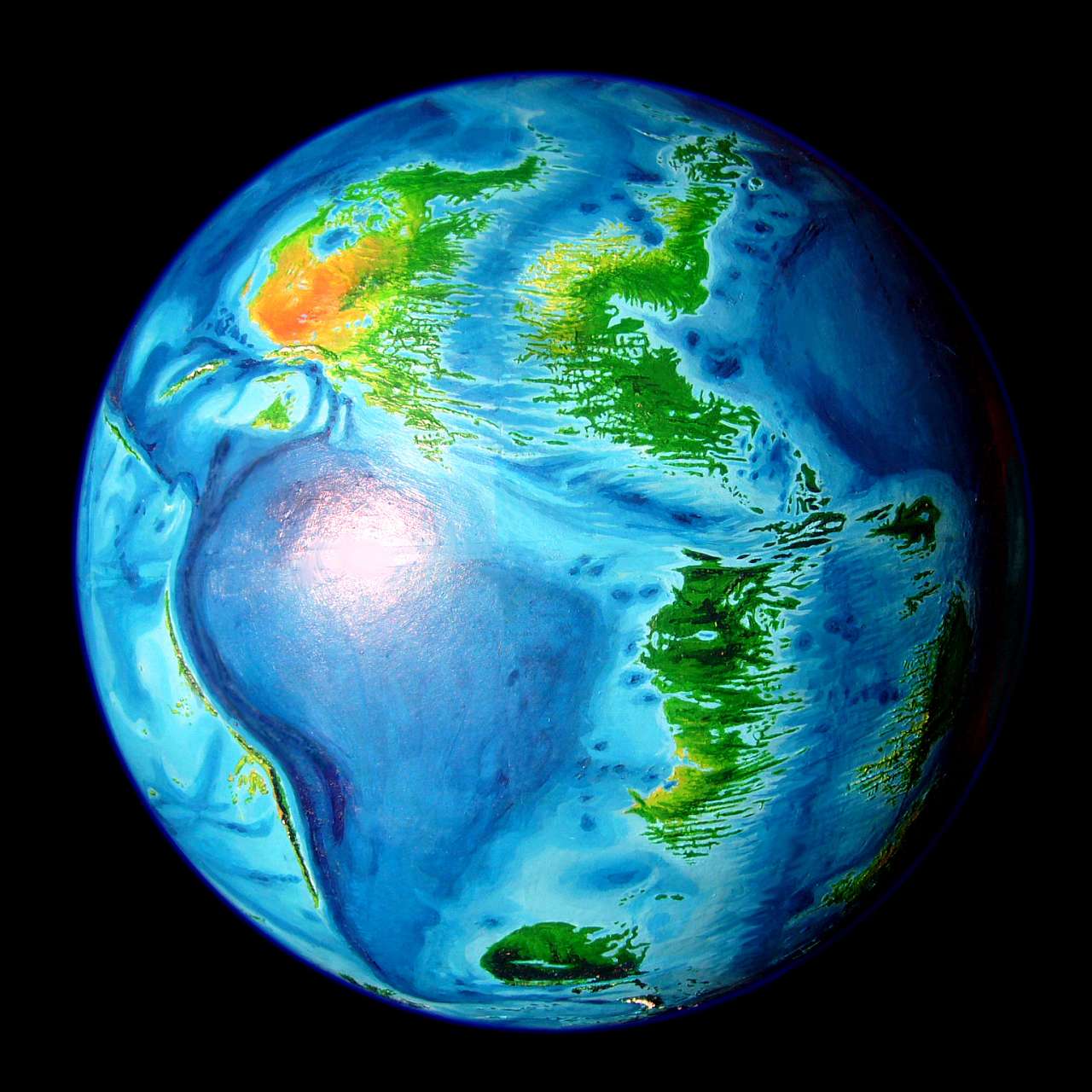
On the southwest coast, the Philippine Mountains are the third highest range in the world. They're perpetually overshadowed (and no doubt tourist-deprived) by the nearby Mariana Range, the highest. Still, peaks from 3 to 4.5 km high (10-15,000') rear in a wall along the southwest coast for 1200 km (750 mi); Mt Samar reaches 5000 m (16,500'), Mt Emden 5400 m (17,700'), and Mt Mindanao over 5600 (18,400').
These peaks truly are Andean in size, and in some ways more impressive; they rise straight from the sea! South of Mt Emden, even in deep winter they only get dusted with brief snows most years, for despite their Alpine height we're under 10° north here; but the northern peaks get real snowpacks. The three giants even have glaciers, though small ones; the only ice on Filipinia.

The wide plains and hills east of the mountains, around the Full Moon River and the Leyte Lakes, are tree-dotted savanna. Fierce rains in summer (rolling in from the east--nothing gets over the towering Philippine Range to the southwest!), but dry most of the year--and even the winters can be hot. It's a bit like northern Australia--a land of extremes. Lakes dry to marsh, then flood again with the next rains--if they don't fail, as they occasionally do. Life here must cope with cycles of flood, fire, and drought. Stunted trees thrust taproots deep; animals migrate, if they can.
As you near the mouth of the Ngeruangel River, the climate grows more humid and maritime again; trees proliferate until a strip of true monsoon forest lines the shore.
Far southern Filipinia is equatorial--the upper Anna River is golden savanna, but downstream it winds through lush forest where the summer rains never fail and the dry season's a relative thing--and a relief when it comes. If it comes.
The washboard ridges and valleys of northeast Filipinia, between Lake Batan, the Central Hills and the east coast from Subaru to Central Bay is distinctly more humid than the west; rains are uneven, but rarely fail entirely. Most of the land is wooded, though opening to scrub and meadow on the west sides of many ridges.
The east coast faces Ngeruangel Sound, as deep as the rich waters off the west coast, but too narrow a 'pipeline' to upwell many nutrients from the oceanic abysses far to the north and south. Yet the fishing's still good: heavy seasonal runoff from the sometimes torrential summer rain fertilizes the sound, alternating with a long dry season of clear water and intense sun; this strong annual cycle nourishes rich if specialized reefs. They're narrower than off most Abyssian coasts: the dropoff into Ngeruangel's depths is precipitous. Undersea cliff-gardens of multicolored corals dropping into blue.
Introduction - Regions & Climates - Western Islands - Vela - Mariana Is. - Peoples & Cultures
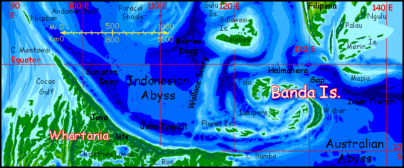
Several hundred kilometers west of Filipinia lie three archipelagoes: Palawan, Sulu, and Sulawesi.
The Palawans
These are three long, narrow, unlucky islands: Palawan proper, some 300 km long but just 45 wide (190 by 25 mi); 200 km to the north, Luzon, only half as long and wide, and beyond it, Dalupiri, smaller yet, though the ruggedest of the trio--its summit ridge is 360 meters high (1200').
Why do I say unlucky? Prevailing winds most of the year leave them in the rainshadow of the mainland. The winter rains, especially on Luzon and Dalupiri, are as short and unreliable as in our Galapagos, shadowed by the Andes (Palawan proper, closer to the equator and farther offshore, gets some monsoon rains in summer). And since they're low, the Palawans can't snag clouds and squeeze out rain, as mountainous islands often do; here, when the rains fail, they really fail. Palawan (Palawian? Palawinian?) life is thus as strange as in the Galapagos--storm-dropped stragglers who toughened up to roll with the climatic punches.
Scattered trees, then, especially on the heights, and palms along the shore, but mostly rock, grass and brush.
The Sulu Chain
A few hundred km south of Palawan is Sulu; from one to three low, rolling islands, none more than 40 km long. You'll note that the map and the orbital photo disagree on whether it's a chain or one island; so do my sources, so far. But climatically and biologically the situation's sadly clear. Suluan species differ only in detail from the Palawans, for the rains here are only a little more reliable. And being smaller and even lower, the Sulus totally depend on the monsoon. Hardscrabble land--scrub, mostly.
Sulawesi
The third archipelago is a very different story. Sulawesi lies further south, well into the equatorial zone. True, this isn't always a guarantee of reliable rain--remember our Galapagos! But the Sulawesi group generally gets torrential summer rains, and even some in winter. The sheer size of the Sulawesis helps too; Celebes is 320 km long (200 mi). Deeper soils, and aquifers big enough so deep-rooted trees can survive the occasional drought. People too; while wells on the Sulus might fail in a bad year, the Sulawesis have rivers. True, they shrink to creeks and ponds during the mild, sunny winters, but they never fail entirely, shaded by lush tropical forests. Fishing villages dot the coasts, and not hardscrabble ones; fruit all year, too. Life here may be quiet--far from the heartlands of Abyssian culture--but among the three groups, the Sulawesis are definitely the place to be.
The Paracels?
There may be a fourth archipelago called the Paracels. May! The Paracel Rise is off the map, nearly 500 km west of Palawan. That far offshore, the Paracels see much less rainshadow effect from the deserts and mountains of Pacifica and Filipinia, so if they're above water at all, I'd expect palm-covered Micronesian islands, though they might be short on fresh water.
But at best they're very low coral islets, and may be mere reefs around a large lagoon, or even a coral-topped guyot 100 or more meters down. The deepest points south of our own Paracel Islands probably aren't deep enough to rise above water on Abyssia--but how far short do they fall? So far my sources conflict almost as much as the overlapping political claims on the islands in our own South China Sea.
But with Abyssia's stable sea levels, unlike Earth's ice-age yoyo, reefs will build up steadily toward the surface and the light. Will anything break the surface? My best bet is no--just extensive shoals and reefs.
Introduction - Regions & Climates - Western Is. - Vela - Mariana Is. - Peoples & Cultures
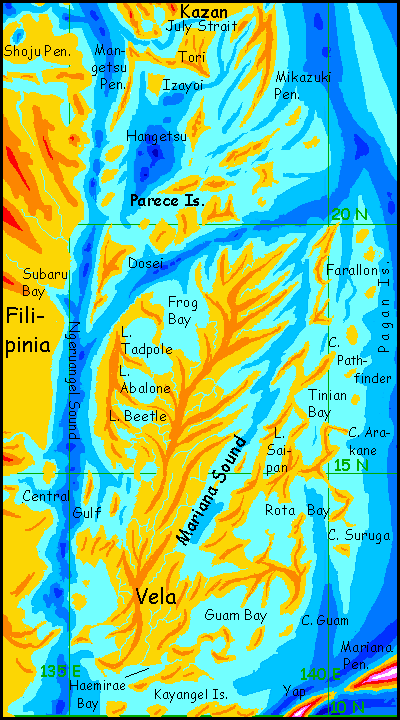
East of Filipinia is a labyrinth: the Vela Archipelago. The Velas seem to be built of fishbones. Arcuate ridges and sounds form a maze like the ripples on a sandbank, but magnified a million times. I'm just amazed at the complexity here. Earth does have a few coasts with this intricate splendor, as if designed by Slartibarfast the fjord-master... but they're all ice-carved. This is tropical--and structural. Not ice or even rain-erosion carved this strange maze.
Note that in this close-up, the orange ridges are only 500 meters high (1600'), not a kilometer high as orange indicates on most other maps. And they're frankly speculative; I haven't seen an accurate, detailed topo map of this region of our sea floor; and I wouldn't fully trust it if I did. I'm sure these ridges are here, but their exact shapes are largely guesswork.
Plus some esthetic bias! I just like tigers.
But that crazy fractal coastline, though it too looks like a tiger on acid, is not fanciful. Fairly accurate! What caused it, I'm not sure, but all Filipinia is under great pressure; it's a tiny but free-floating tectonic plate, being squeezed east and west. Around it are the highest ranges in the world, after all...
That's a climatic problem. Water, water everywhere, but not much of it rain. The lesser islands at the north end of the archipelago (lesser as in "Kazan, the size of Ireland") are at latitude 20-30°, with deserts and mountains upwind, both east and west; inevitably, they're dry. The hills do get a little rain, but they aren't extensive or high; most of Kazan and Tori, the largest in the north, are low, rolling, rocky scrubland.
The northern Velans--what natives there are, that is--huddle at the mouths of the few tiny creeks or coastal springs, and live off the sea. The Philippine and Ngeruangel Sounds have coral reefs in the shallows, but run quite deep, and prevailing winds drive loops of surface water and cold, nutrient-rich water from the depths. Fishing is superb.
Vela, well to the south, had better climatic luck. Bracketed by high mountains still, but well inside the tropic zone; summer monsoons sweep the island, weak and unreliable in the north but enough for forest in the southern half.
And geography counters climate--to some extent. On Vela there's no "coastal" and "interior"--every inch of the great island is coastal, or near enough. Maritime climate prevails, and those ridges snag clouds and squeeze out rain. While the deserts and mountains of Pacifica still lessen the rain you'd expect at 15° north, keeping Vela from looking as lush as our Philippines, it's no desert island. The hot sunny southwestern slopes of these ridges can be dry--baby veldts, minideserts--but overall, the land looks quite Caribbean, just as the archipelago's long, twisting isles and capes resemble the strange stretched shapes of the Bahamas... scaled up a lot.
Vela alone is as big as Java. Or England.
Fresh fruits and vegs. And the fishing's still good.
Introduction - Regions & Climates - Western Is. - Vela - Mariana Islands - Peoples & Cultures
A very different place! Abyssia may have drowned Indonesia, but as you sail down this chain of long green sinuous islands studded with tall volcanoes, you have to admit the Marianas are a pretty authentic replacement.
Cape Mariana out-Indonesias Indonesia. Mt Manyasu, near its tip, is 4900 m high (16,100'), quite comparable to West Irian's Mt Jaya, highest peak in our Pacific; and Manyasu rises dramatically out of the sea, with no coastal plain. A single sweep from beach palms to snow!
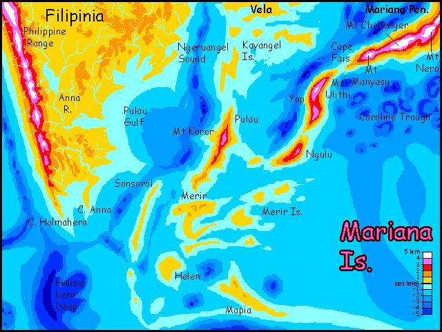
East of Manyasu is Mt Challenger, the highest peak in the world, fully 6200 meters (20,300'), rising from tropical jungle to an impressive icecap. Well, from jungle on the north side; the south is much opener forest, even some high-altitude desert above the cloudline; for this slope gets full sun and much less rain. A mountain this big creates its own climate.
Off the tip of Cape Fais is Yap, a tilde-shaped island 320 km (200 mi) long, with at least two Fuji-size volcanoes. Mt Ulithi, in the north, is probably the taller, at 3750 m (12,200'). Nearly all of Yap is rainforest or cloudforest, almost to the summits. No surprise: we're less than 10° from the equator here. Only a small stretch of the southwest coast, in the rainshadow of the mountains, opens up at all.
Ngulu, just to the south, is unequivocably tropical. Mt Ngulu tops 3500 m (11,500') but is smothered in cloudforest right to the rim of the smoking summit crater.
Palau, 300 km west, is a narrow island fully 400 km long (250 mi), just as wet and green as Ngulu. As rugged, too; Mt Koror in the north is 3200 m high (10,500').
South of these volcanic ridges is a broad flotilla of very different islands--low, gentle, in a mostly shallow sea. Sonsorol, Merir, Helen and Mapia are from 1-300 km long, with a halo of lesser islands scattered across the Caroline Sea. Straddling the equator, this archipelago gets over 3 meters of rain a year (120"+). Even the smallest islets overhang with trees right down to the tideline, like monster green mushrooms.
I've called the Mariana archipelago Indonesian, but it lies well northwest of our Indonesia. 500 km to the southwest, in the heart of our Indonesia, there's a yet another archipelago rivaling the Marianas: the Banda Islands. Strange--you wouldn't think our Indonesia had room for much deep seafloor to become Abyssian islands! But Indonesia is tectonically compressed--tormented, even. Trenches and abysses abound--creating, on Abyssia, the Bandas. Like the Marianas they're a mix of high volcanic and low coral islands smothered in rainforest. The archipelago is a bridge to the third largest continent, Whartonia, and the dozens of great islands and small continents beyond, all the way to Atlantis itself.
Introduction - Regions & Climates - Western Is. - Vela - Mariana Is. - Peoples & Cultures
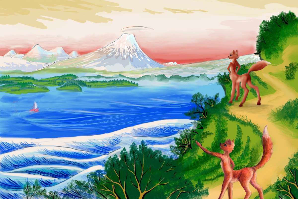
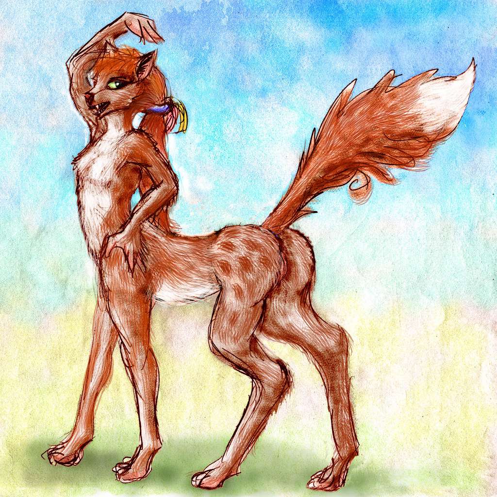
Two intelligent species dominate Filipinia. Their ranges overlap, but generally fit the north-south belts of wet and dry that you've already seen.

Unlike Terran cassowaries, the kasowar have forehands as dexterous as any ape, and can climb trees fairly well--not as readily as chimps, but better than most humans (they're much lighter, for one thing, and those vestigial wings slow any falls from painful to merely humiliating). A large part of their diet is fruit, nuts and greens harvested from the forest canopy, though much supplemented by fish caught in streams. These days this farming/gathering life is only part subsistence; much of the forest is closely managed and planned; foods, medicines, and quality hardwoods are grown for export not just local needs.
There are only a few in the damp, muggy south, though. You'll meet some in port towns and, if you're a hardcore climber and trekker, in a few villages above the cloud forests of the Philippine Range, where it's relatively cool and dry.
Abyssia's homepage - map - peoples - regional tours - names
LISTS AND LINKS: More worlds? Planetocopia! - dreams of other worlds - ecology - climate change - evolution - natural disasters - terraforming - sculptures and 3D art -
World Dream Bank homepage - Art gallery - New stuff - Introductory sampler, best dreams, best art - On dreamwork - Books
Indexes: Subject - Author - Date - Names - Places - Art media/styles
Titles: A - B - C - D - E - F - G - H - IJ - KL - M - NO - PQ - R - Sa-Sk - Sl-Sz - T - UV - WXYZ
Email: wdreamb@yahoo.com - Catalog of art, books, CDs - Behind the Curtain: FAQs, bio, site map - Kindred sites