Abyssia:
South Pacifica
by Chris Wayan, 2013-2017
for jungle dwellers of every shape
Abyssia home - down to map - building Abyssia - geology & geography - critters & cultures - the clash of names - more worlds? Planetocopia!
Abyssia:
South Pacifica
by Chris Wayan, 2013-2017
for jungle dwellers of every shape
Abyssia home - down to map - building Abyssia - geology & geography - critters & cultures - the clash of names - more worlds? Planetocopia!
Overview - Peoples - North - West - Great Lakes - Penrhyn - East
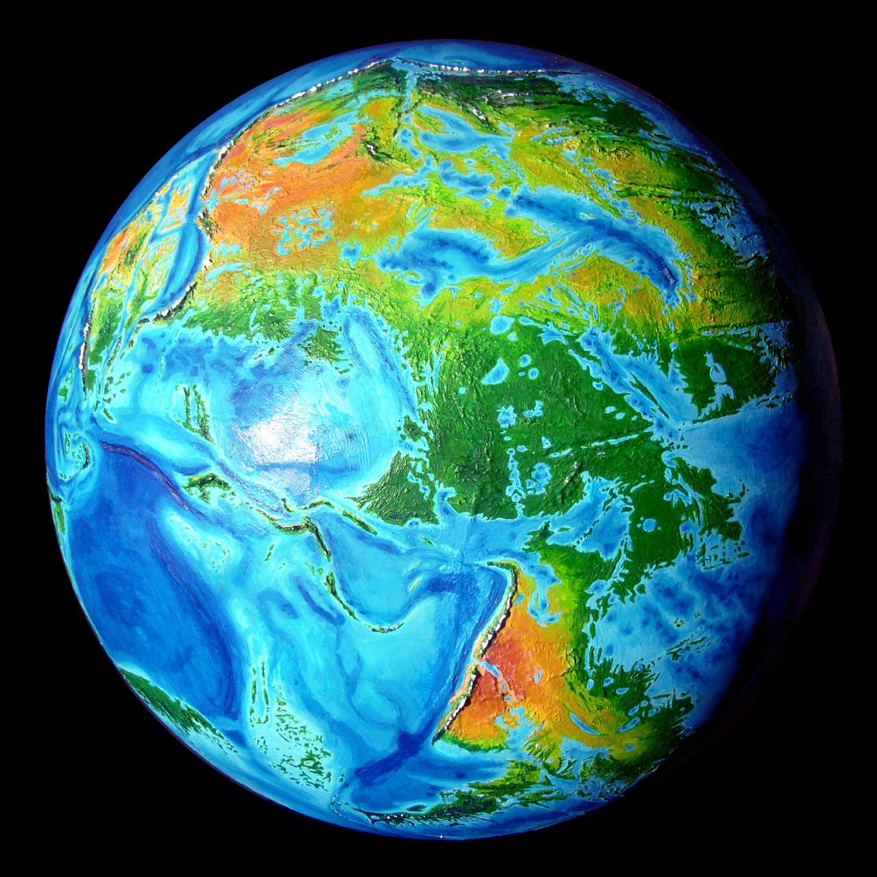
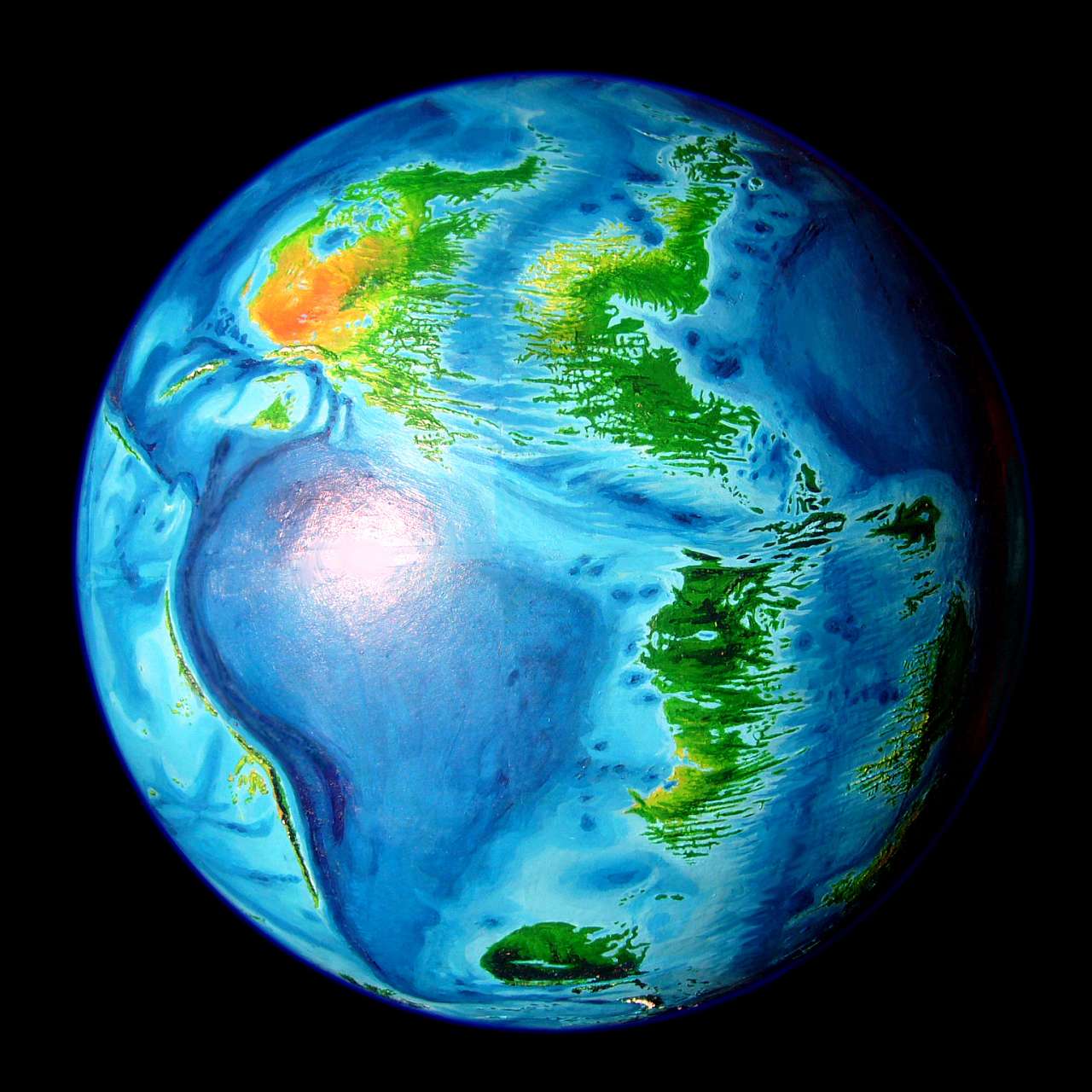
South Pacifica's simple, big and drastic: it's Amazonia. Or, better, a gigantic Indonesia, since it's broken up by water, both fresh and salt. All of it's tropical; all of it's rainy; all of it's hot; and most is dense forest.
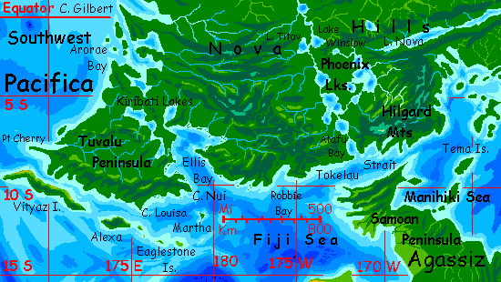
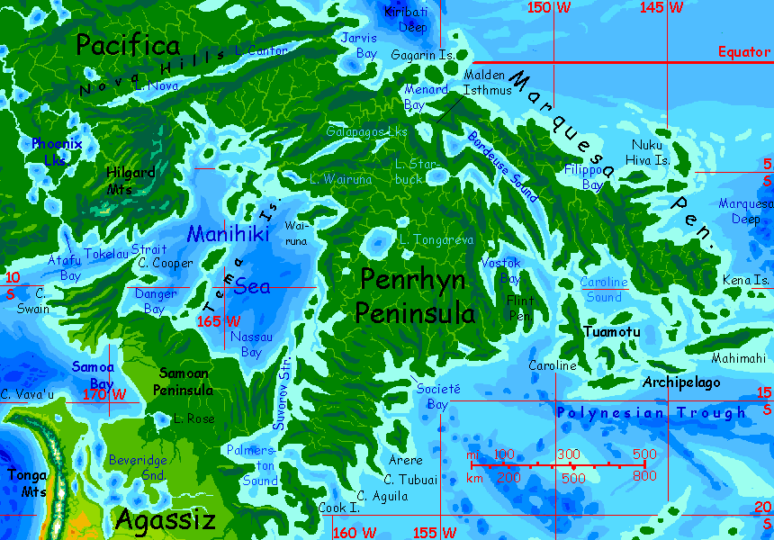
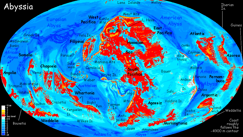
The sketchmap below has many errors of detail, but should at least orient you.
Overview - Peoples - North - West - Great Lakes - Penrhyn - East
Will this great rainforest have a significant population? Ours don't, generally--just the coasts, where the sea offers easy transport and fishing adds protein. Inland, rainforest floors--all that's safely accessible to humans--is dark, damp, and protein-poor. But will Abyssians be the same? Most of the intelligent Abyssian mammals I've postulated evolved on savanna; they'd find this rainforest nearly as impassible as humans would. Brainy critters probably do roam these woods: remember our elephants and apes! But will any develop sophisticated culture? Uncertain.
Abyssian vertebrates as I've postulated them have six limbs; this centauroid bodyplan often frees up forelimbs to use as hands. Would that help mammals reach the light and air (and food!) of the canopy, yet retain dexterity? Creatures suited to canopy life will mostly be small; falls become deadlier the bigger you get. Hands of large mammals must be optimized for branch-grasping, not dexterity. I suspect that includes forehands. Gorillas and chimps are dexterous for the animal kingdom as a whole, but their hands must do triple duty--knuckle-walking, tree-grasping, and manipulation. The third suffers because the second MUST be optimized; slip and you die. I fear it's as true for hexapeds as for quadrupeds.
What of avians? Since local birds face the same gravity and air pressure that Terran creatures do, I can't hope that fliers will grow much larger or more intelligent than Earth's largest parrots (admittedly, that's smart!); but true avian people on Abyssia are likely to be big and flightless--ground-bound like the cassowary.
Or maybe not. Light bones, feathers making you bulky for your weight, and wings that you can't fly on may still slow a fall! So the Abyssian equivalents of cassowaries that I'm postulating may be flightless yet not need extreme tree-grasping specialization in their hands to be at least partly arboreal... freeing them to make and use tools.
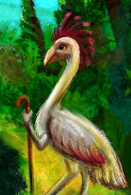
A kasowar, Palmyra Gulf |

A tree-squid, Phoenix Lakes |
One wild card might not be vertebrate at all, but a sort of tree-climbing octopus or squid. They'd do well in the heart of the rainforest--half the forest floor is underwater in the wet season. These shy, secretive molluscs might well sign rather speak aloud and camouflage themselves by matching leaf-colors and patterns. Maybe they've been everywhere and we've just overlooked them.
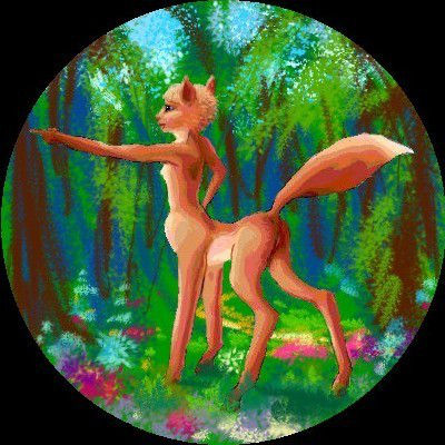
What of non-native people? The prairies of central Pacifica, well to the north around the Hawaiian Sea, are the home of a people we'll call foxtaurs (their own name is "Yipyaaayapwhishyi", which I can't possibly type as many times as it'll be needed, so to spare my poor, human, qwerty-gnarled fingers, let's keep it short and descriptive. They're an easy-going people used to trade with strangers who can't pronounce their name--some of whom don't even have lips--so they won't take offense). They won't mind the heat of South Pacifica, but the rainforest is awfully wet for them. Still, many can be found around the fringes--in the opener woods of the north and around Victoria Sound in the west. And in port cities all over--foxtaurs are decent sailors and like to roam.
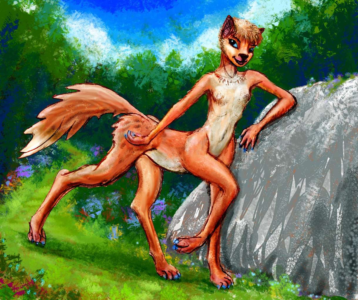
Here's a Victorian foxtaur--unusually tall, fully 1.4 meters (about 4'7"), but typically gracile--slender and spidery for heat-dispersal. Evaporative cooling won't work in the jungle! Veterans of tours in other foxtaur-settled regions will notice that most northerners you saw looked shorter, stockier, bustier, short-necked.
The source for her peculiar gesture? A model in Vogue intrigued me, leaning and gesturing like this--though she had just two legs, so she looked quite wobbly. How do those bipeds keep from falling over? Sloppy design, Mr. Darwin! Falling over's not my ideal of grace. But this narrow-minded fashion rag does not hire centauroids. Surely the slender Victoria Sound subspecies embodies the Vogue ideal--and without dieting, too. O the injustice!
Overview - Peoples - North - West - Great Lakes - Penrhyn - East
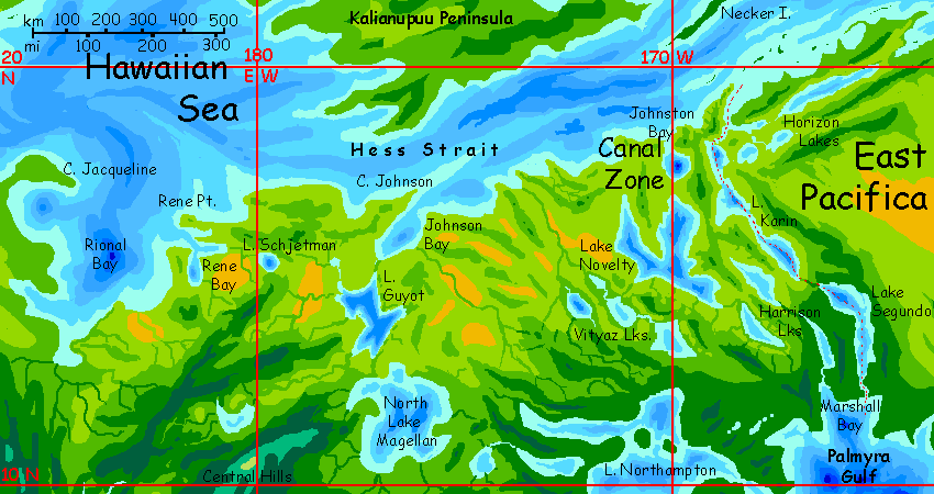
The north and northwest are the driest lobes of this rainforest--not dry, but less relentlessly moldy. In the north, bordering East Pacifica and the Hawaiian Sea, open woods and meadows line the fingerlakes on and around the busy Hawaiian Canal. These lakes (and bays like Marshall and Johnston) are the equivalent of our northern Line Islands--well, mostly seamounts in that long chain that don't break the surface. They aren't a simple line but several parallel chains--on Earth, lesser hotspots, little sisters to the giant that built Hawaii.
The Hawaiian Canal carries all shipping to and from the great inland sea--Abyssia's Strait of Gibraltar. 95% of the Canal is natural of course; a watermaze of long lakes like Segundo, Karin, Novelty, and the Harrison Lakes nearly link the seas now, and probably do so directly in slightly wetter eras when the Hawaiian Sea brims a few yards higher.
Not that the Hawaiian Sea was ever a freshwater lake; even in the rainiest eras, it's just too big to flush out entirely. But the brine may retreat to the deeps, under a surface skin of sweeter water. Brackish not fresh; I doubt it ever got drinkable, at least to human taste. Though the Pacificans, whether burrowing Foxtaurs or vultury Pitians or leathery Tree-squid or huge flightless Aepyornises, may have quite different salt tolerances and water needs.
Overview - Peoples - North - West - Great Lakes - Penrhyn - East
The northwest has monsoon forest whose dry season lengthens until the woods thin to savanna and desert in western Pacifica. But the weather makes up for that in a fierce monsoon with heavy flooding in the summer months; it's much like our Northern Australia, with its strong wet and dry seasons.
As in Australia, the pleasantest parts are by the sea and offshore: Bikini Bay, Ratak Sound, and the huge Isle of Marshalia.
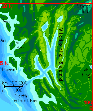
In the west are the parallel fjords of Victoria Sound with many cliffs and waterfalls; it's perhaps the most scenic region of South Pacifica. Both the west coast and inland (east of the Sound) are rainforest, but the woods open up around the Sounds--the parallel ridges framing the Sound rise across the prevailing winds, catching and weakening storms here. The lowlands often open to patchy savanna, freckled with lone trees and little groves.
The heights above, snagging clouds, are dense-forested. Scenic to visit, especially canyons with waterfalls... but a drippy place to live.
As I mentioned in Peoples, this region, because it's more open and less rainy, is prime foxtaur country--their farms dot the sounds, wherever there are coastal flats, and foxtaur-tended orchards cling to many lower slopes.
South of Victoria Sound, around Cape Gilbert and Arorae Bay, the great rains sweep right across the continent, coast to coast; we're right on the equator here. As close to Amazonia as Abyssia gets!
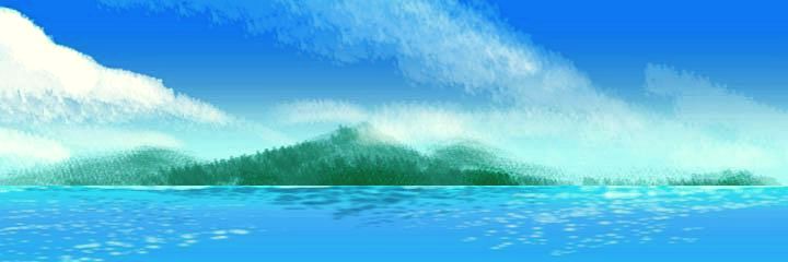
In the southwest is Tuvalu, a chunk of lowland rainforest as big as Borneo, nearly cut off from the mainland by Arorae and Ellis Bays, and the Kiribati Lakes.
On Tuvalu, the forest opens a bit on the inland slopes of the south-coastal mountains, but even when you've rounded Cape Cherry and head east along the south shore of Tuvalu, all you see is a great wall of green trees and grey mist; the coast side is seamless rainforest. Seamless for 1300 km (800 mi), from Cape Cherry past Louisa Head all the way to Cape Nui. The great peninsula's jungle coast to coast; even the smallest islets off Cape Nui and in Ellis Bay overhang the water like big green mushrooms or monster broccoli heads.
Here you won't find many foxtaurs; this is kasowar and tree-squid country.
The southwest coast of mainland Pacifica, from Ellis Bay and the Isle of Martha east to Tokelau Strait, is a bit farther from the equator, but still only ten or twelve degrees; the forest is still unbroken. But there's a distinct winter dry season on the coast--well, less torrential rains than in the muggy summers, at least.
And muggy springs.
And muggy falls.
The locals don't mind the damp clingy heat, but most human tourists will find winter the only bearable season.
Overview - Peoples - North - West - Great Lakes - Penrhyn - East
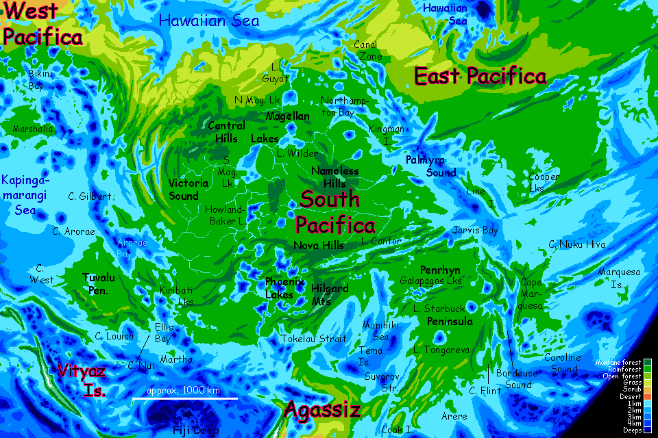
Running between the Central and the Nameless Hills, right down the middle of South Pacifica, a chain of great lakes nearly splits the subcontinent. North to south, they are Lake Guyot (yes, in our world it was the huge, strange flat-topped seamount that guyots were named for; but on Abyssia, naturally, the word means a miles-deep but flat-bottomed lake!), North Magellan, South Magellan (each 250-320 km or 150-200 mi wide); Howland-Baker, nearly as large, smaller Titov and Winslow nestled in the Nova Hills, then the Phoenix Lakes (seven lake-basins at least, but the lakes may rise and merge before they find a channel draining them to Tokelau Sound).
The basins feeding these great lakes are all lobes of a single vast rainforest, as large as Amazonia. It's more densely populated by Abyssians than our rainforests are, because kasowars, the dominant species on the continent, can climb trees better than humans; they harvest the bounty of the canopy, where humans are stuck in the gloomy (and protein-poor) understory, unless they slash and burn to open up clearings--and we know how badly that often works out.
But in Great Lakes country, even rainforest canopies 50-60 meters up (160-200') are semi-wild fruit and nut orchards.
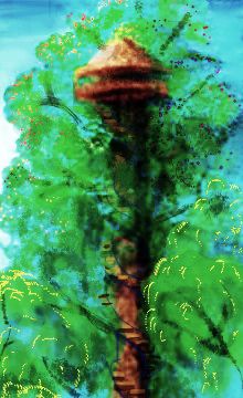
In the most developed regions along major rivers, where such orchards routinely export much of the crop, some trees will have crude spiral stairs for non-kasowar traders to inspect produce first-hand; here you may be able to visit the canopy. After the green-brown gloom of the forest floor, an explosion of light and color! Flowers, fruit, hand-size butterflies, birds like jewels. Like coral reefs--but mid-air. A canopy visit is highly recommended...
...unless you're prone to vertigo; kasowar understand double-entry bookkeeping and import/export treaties, but they lack the concept of railings.
These tours are full of sketches of scenery and portraits of the local people, but as I show endless centaurs and huge flightless birds--definitely not Earth!--I've neglected the smaller scale and nonintelligent species. They are there! And frankly, that everyday world of plants and small animals looks very Terran. Same conditions, after all.
It's true that small mammals and lizards do look exotic--that centaurian body plan--and the increased dexterity of those dedicated little forepaws means nests and burrows (and tool use generally) are more visible even to the casual tourist's eye.
But there are plenty of Abyssian birds barely distinguishable from Terran ones, birds whose forehands are small, used mostly for grooming and nest-building, as delicate--relatively speaking--as the forearms of their great-aunts and -uncles, the tyrannosaurs. When songbirds perch, those forearms are tucked away under the wings; scarcely noticeable to the casual eye.
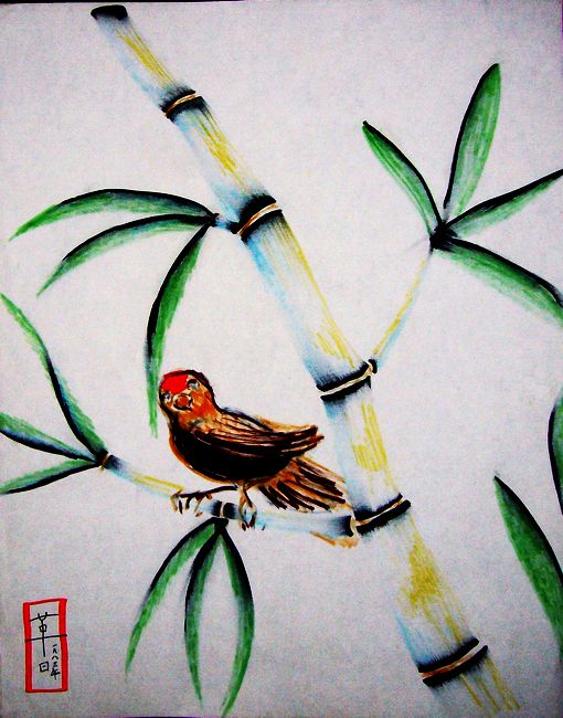
Here's a typical sight in the western Hilgard Mountains, from the sunnier zone a bit above the cloudforests. Here, bamboo thickets take advantage of the sun, and small songbirds quite like Terran red-cap sparrows nest.
Since it's bamboo, I sketched it East Asian style, though it's not really sumi ink and brush: it's feltpen smeared with my fingers while still wet. Same effect. Except it turns out feltpen doesn't easily wash off your fingers. I'm an inept gardener; but for two days, I really had green thumbs.
The Great Lakes range from 3 to 5 km deep; any one of them contains more fresh water than any lake on Earth; the whole chain holds more than all the lakes on Earth together. And many lakes elsewhere on Abyssia are just as large, just as deep. Despite its smaller continents, Abyssia has ten or twenty times Earth's fresh water! It's a rainy, maritime world without the cooling/drying effects of ice sheets--but that only guarantees the water, not basins to put it in. That's structural: many rifts and fault zones hidden on Earth are exposed to rain here, creating lakes much like our Baikal and Tanganyika. And Abyssia has way more caldera-like pits where crust subsides (called coronae) than cones where it erupts and builds up (you may have heard that word: volcanoes).
On the other hand, Earth's worst recent volcanic explosions, Tambora and Krakatoa, were both in Indonesia. Not exactly desert!
Anyway, South Pacifica's tectonically busy, but most crust moves sideways or inward not outwards. Australia-sized mountains at most--but very deep pits. And in the equatorial rains, they all fill into lakes, and brim over.
Overview - Peoples - North - West - Great Lakes - Penrhyn Peninsula - East
This chunk of Pacifican rainforest thrusts from the continent's southeast much like our Indochina--just as green and just as big! Penrhyn is fairly compact with one exception: on its east side, across Caroline and Bordeuse Sounds (winding and full of sinuous ridgy islands), rises Cape Marquesa, a peninsula nearly as big as Borneo. The islands of Caroline Sound resemble those of our Polynesia--not surprising, since they're right next door--those deep blue freckles east and south of the Caroline Islands and Penrhyn are the Abyssian equivalents of Polynesia's volcanic pimples.
Penrhyn Peninsula shelters the deep but nearly landlocked Manihiki Sea. The rivers of Penrhyn and northern Agassiz, the southern continent, are so copious, fed by heavy year-round rains, that Manihiki's surface water is merely brackish; it's nearly the world's largest freshwater lake. Not quite: the Hawaiian Sea, in central Pacifica, is also brackish, drinkable in spots... and as big as the Mediterranean!
Parda, leptaur busker from Atlantis |

Sovin, peacock trader from Somalia |

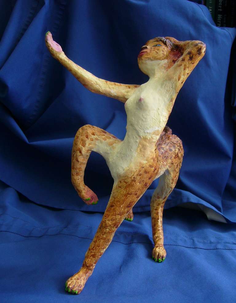
Rira, eq dancer from Agassiz |
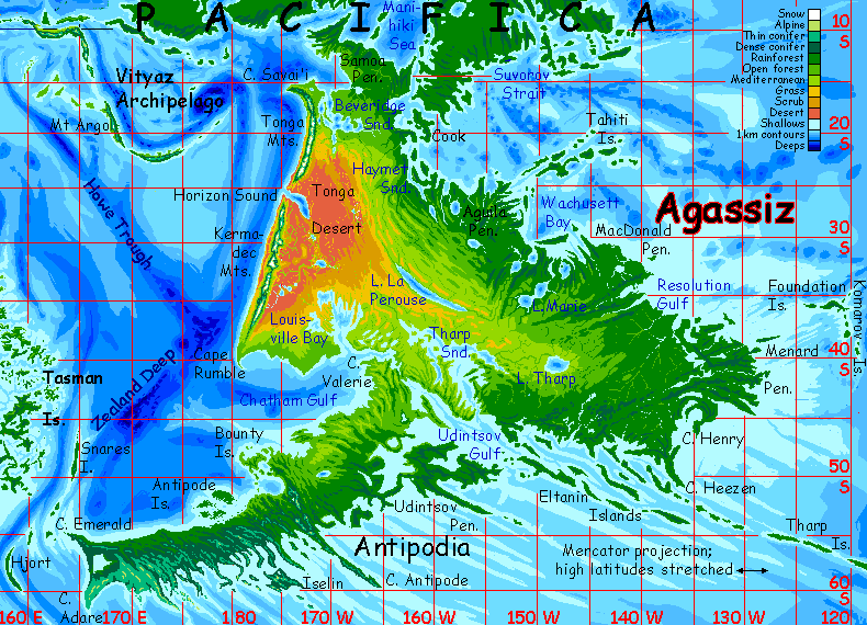
Across Suvorov Strait is the northern shore of Agassiz, second largest continent in the world; rugged, drier, more African; its savannas are nurseries for at least three of the species you saw in Port Suvorov--the graceful centaurian Equi, the looming, massive, feathered Moas, and the smaller, screeching, flying Kurituks.
Overview - Peoples - North - West - Great Lakes - Penrhyn - East
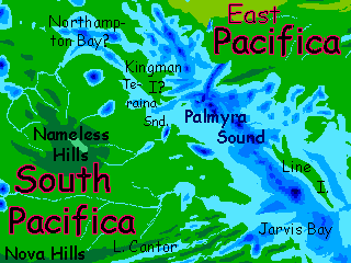
The east coast, from the Marquesa Peninsula all the way north along Palmyra Gulf to the Canal Zone, is unbroken rainforest. Inland, there may be opener woods and even a few meadows on the west side of the Nameless Hills and the inland slopes of the Hilgard Mts, but overall this is the biggest unbroken rainforest in the world--and Abyssia's full of them.
North from the base of the Marquesa Peninsula, the most notable feature is Jarvis Bay. Modest in scale next to the huge sounds we've seen farther south, but the geological manifestation of a deep vigorous fracture running a couple of thousand kilometers inland. That's perfectly visible--steep craggy ridges surround the bay. They're just one end of the Nova Hills. Folded between those ridges are long, narrow Lake Cantor and Lake Nova. Even the Phoenix Lakes far to the west may be related features.
In the heart of Palmyra Gulf is a narrow island some thousand km long, Line Island, rises abruptly and steeply from the Gulf, crests in a single ridge, and plummets back into the sea. As straight and slender as its name suggests--though in fact it's named for our world's Line Islands, twin seamount chains with a narrow trench between them.
I'm ashamed to say I'm not too sure of my geography along the northwest Palmyra shore. There's a deep bay like Jarvis (equivalent of quite a large seamount on Earth) that I can't find a name for, then Teraina Gulf, whose existence I'm sure of but whose shores are hazy, and then a Kingman Island-or-Cape (not clear! swampy terrain!), and then huge Northampton Bay-or-Lake (ditto!)
Don't worry. You won't see them much, anyway. Rain, rain, rain.
At the very head of the Gulf, things get clearer--weatherwise, as the clouds break up, and geographically--ahead is the Canal Zone, a clear, definite coast with narrow lakes fringed in forest and savanna ridges running north all the way--under blue skies, not gray--to the Mediterranean delights of the Hawaiian Sea.
Abyssia's homepage - map - peoples - regional tours - names
LISTS AND LINKS: More worlds? Planetocopia! - dreams of other worlds - ecology - climate change - evolution - natural disasters - terraforming - sculptures and 3D art -
World Dream Bank homepage - Art gallery - New stuff - Introductory sampler, best dreams, best art - On dreamwork - Books
Indexes: Subject - Author - Date - Names - Places - Art media/styles
Titles: A - B - C - D - E - F - G - H - IJ - KL - M - NO - PQ - R - Sa-Sk - Sl-Sz - T - UV - WXYZ
Email: wdreamb@yahoo.com - Catalog of art, books, CDs - Behind the Curtain: FAQs, bio, site map - Kindred sites