World Dream Bank
home -
add a dream -
newest -
art gallery -
sampler -
dreams by
title,
subject,
author,
date,
places,
names
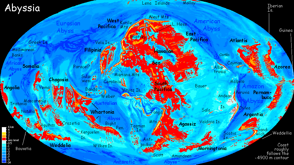
Abyssia:
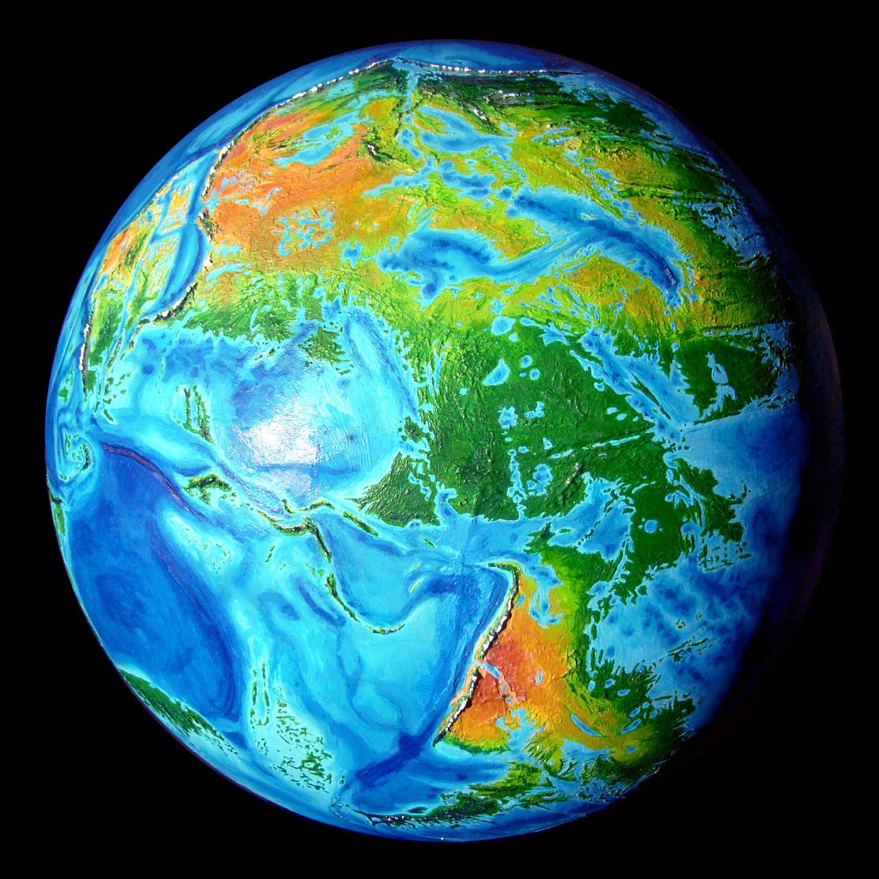
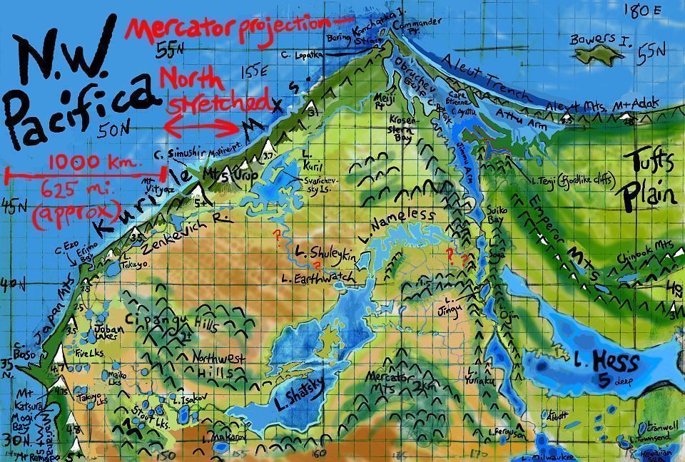
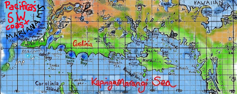
West Pacifica
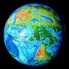

by Chris Wayan, 2004-2017 (Abyssia was a long time coming)
For desert foxes and fennecs, whether or not you cruise the net
Abyssia home - down to
map -
building Abyssia -
geology & geography -
critters & cultures -
the clash of names -
more worlds? Planetocopia!
Overview
-
Climates -
Pitted Desert -
Foxtaurs -
Northwest -
Shatsky Basin -
SW Coast -
the Marianas -
Emperor Chain -
Western Is.
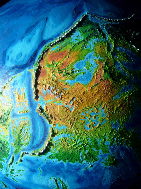
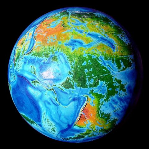
Western Pacifica's dominated by three features
- The Mariana Mountains, highest in the world. Mt Challenger tops 6 km (about 20,000'). And that's just their height above water; the Mariana Trench runs just offshore (the equivalent of our world's Mariana Islands). Head to toe, the mountains are 10-11 km tall (33-36,000'). Still, that's not even waist-high to Mt Olympus on Mars. No surprise--aside from being topsy-turvy, Abyssia is Earth, with Earth's high gravity; 10-15 km seems to be about as much vertical displacement as our crust can take. The Marianas aren't the world record: that's on the long Isle of Chilea, where the Andes Range tops out at 3.2 km high (10,500'); the Andes Trench offshore is as much as 11.5 km deep. So the Andes, head to toe, reach 14.7 km; a bit past the waist of Olympus. Since Abyssia is just Earth with a minus sign, this is true of our Andes too--they're much taller than the Himalayas! Just waist-deep...
The Marianas, with their northern sisters the Kuriles, form a narrow but nearly unbroken western wall blocking storms off the Eurasian Ocean from watering western Pacifica. This creates the...
- Pacifica Desert, by far the largest on Abyssia--indeed, bigger than all the world's other deserts glued together. Like our Sahara, it fades imperceptibly into the temperate zone to the north and a tropical monsoon belt to the south. To the east the desert breaks up slowly around scattered wooded ranges (lower and far more broken than America's Rockies) and fades into dry grasslands and finally fertile prairies around the Hawaiian Sea. To the west and northwest, the Kuriles wall the desert in from reaching the coast, but in the southwest it spills over the Mariana Range to reach the coast, just as America's southwestern desert breaks through around the Gulf of California and Baja; at this latitude most winds come from inland.
- Pits dot the desert, most cupping salt lakes, like a hundred Dead Seas, Badwaters and Turfan Depressions; but these pits are kilometers deep! The equivalent of Earth's volcanic seamounts in the Western Pacific, these pits have very strange conditions in their depths, and host very strange life. Their dense air allows much larger creatures to fly than are feasible on Earth today. They may be crucibles for the only intelligent fliers on Abyssia, who we'll have to name the Pitians, I guess.
Pits aside, Western Pacifica's terrain is like a drastically simplified North America: an eastern plain gradually growing drier inland, then desert, then snowy mountains, then a narrow coastal strip that varies from temperate to Mediterranean to dry to tropical rainforest.
Western Pacifica, like Western America, is under great tectonic pressure. Volcanoes, quakes and tsunamis are common. Whoever lives here, they won't build cathedrals. Or, along that vulnerable coast, anything much...
Overview -
Climates
-
Pitted Desert -
Foxtaurs -
Northwest -
Shatsky Basin -
the Marianas -
SW Coast -
Emperor Chain -
Western Is.
Western Pacifica is big and rugged; its climates are much more diverse than the East or South. Along much of the coast, the prevailing winds are off the land, not the sea, and rarely bring rains. It's not as extreme as the Bolivian Andes and the Atacama Desert--the Mariana Coast gets fogs along the shore, and gentle rains in winter--but the latitude and landforms are similar. The fishing is comparable too: in most years those seaward winds blow surface water offshore, causing deep water rich in nutrients to upwell, creating some of the richest fishing in the world--and that's saying a lot on Abyssia, with its vast teeming coral reefs. Fishing villages will thrive--though only at the mouths of perennial creeks, snowmelt-fed. Yes, snow even near the equator; the Mariana Mountains are plenty high enough, and the Kuriles, though slightly lower, are still Alpine, and in temperate latitudes. So, snowmelt. Irrigating these sunny coastal valleys will yield rich crops.
The Mariana Mountains are the highest range in the world; peaks 5-6 km high (16-20,000') rear in a wall along the southwest coast for 2500 km (1500 mi); Mt Challenger reaches 6120 m (20,100') at the south end; Mt Ramapo, in the north, 5450 m (17,900'). These and a few others like Mt Nero (5100 m) are truly Andean in size, and in some ways more impressive; they rise straight from the sea!
Earth has more land and higher mountains, but few spectacles to match the Marianas--perhaps Colombia's Santa Marta range, rising nearly 5800 meters from the Caribbean sea (19,000'), or Mt St Elias on the Alaskan coast, nearly 5500 (18,000').
The greater Mariana Range runs all the way along the west coast, but there are gaps between the Kuriles in the north, the Japan Range in the middle latitudes, and the Marianas proper in the south, themselves broken into several sections with sounds between. They aren't the Himalaya; cross-mountain trade won't be hard. It's ecologically that they form a nearly unbroken barrier. The gaps just aren't wide enough to let much rain in from the sea.
Overview -
Climates -
Pitted Desert
Foxtaurs -
Northwest -
Shatsky Basin -
Marianas -
SW Coast -
Emperor Chain -
Western Is.
The Pitted Desert inland is not the Sahara--smaller, and much more broken-up by the extraordinary altitude changes--both above and below sea level. Still, it's the world's largest, hottest and driest desert by far. Not a safe place.

This is the most ecologically alien region on Abyssia. I'm still wrestling with its complexity--especially the evolutionary implications of those miles-deep pits. That high air pressure will foster huge intelligent avians--but what sort? They'll be strange. And can they spread, can they adapt to sea-level life if they do achieve civilization, or will they be trapped in their pits?

These questions are explored on the Creatures and Cultures page--the sections Aeps, or, the Fall from Bird Heaven, Angels of the Pit, and Of Aeps and Angels. To summarize:
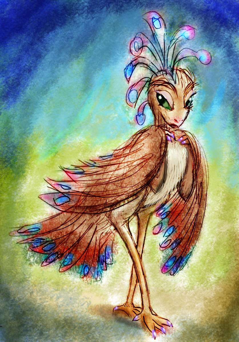
In the deserts of Pacifica, a few pits yawn three miles deep. Their lakes have receded until the evaporation off their shrunken faces drops to match their scant inflow. Modern Earth's closest equivalent, the Dead Sea, is just a few hundred meters down. These are thousands! Up to five kilometers below sea level.
And in their depths, on the shores of tiny briny seas, along creeks that are more waterfall than stream, life has adapted to what might as well be another planet entirely. Oven-heat, salty and alkaline soils, yet weirdly humid for a desert, with mild sun and little ultraviolet--you slowly bake but never sunburn in that hazy light. Strangest of all, air pressure rises down in these pits--up to twice as dense as at sea level.
Here, and here alone on Abyssia, the size-constraint on bird-intelligence is lifted; if there's social pressure toward larger brains and higher intelligence in the "handed" Abyssian equivalents of parrots or corvids, here the body can indulge it; the maximum flight-weight is double Earth's. There is a mild counter-pressure: summer and winter, it's relentlessly hot here. But that can be solved by nocturnality or siestas, ranginess, pale colors, less down, or vulturelike baldness except on the vital wings and tail. Though plenty of normally feathered birds live in our hot deserts. Water and food, not temperature, are the limiting factors.
Lake Tori, in the heart of the Pacifica Desert, is the deepest, largest pit I'm absolutely sure will BE a pit--and thus a possible home for such intelligent fliers. Huge Lake Pigafetta/Gordin/Alba to the south will have variable Sahelian rains, and those plus runoff from the nearby mountains will mean its pit, though the biggest on Abyssia, will be just 2-3 km deep.
So I think my fliers will first evolve five km down (16,500' below sea level!) in Tori Basin (Japanese for "bird"! How apt.) Here the air is densest and the smallest wings are needed. Then they'd colonize the big southern complex and adapt for thinner air--preparing them for sea-level flight. Pigafetta is an atmospheric halfway house!

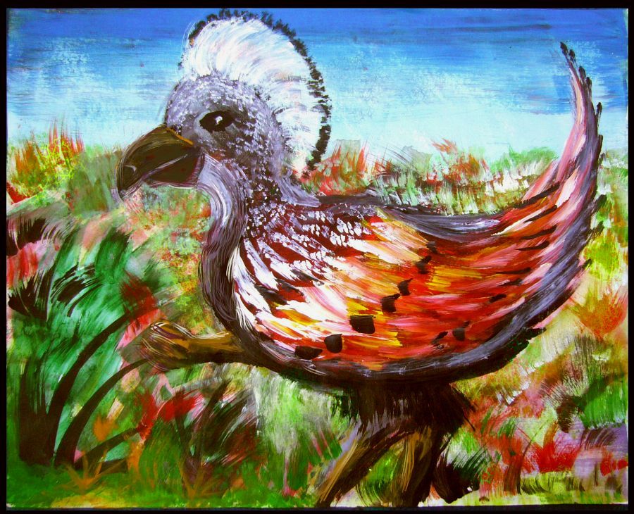
My portrait above of a 5-kilo (11-lb) Torian woman as a sort of super-parrot with a quasi-human face isn't meant to be very realistic, but she does bring up a real question. Must all Abyssian birds have beaks, indeed look at all like Terran birds? Plenty of flying dinosaurs had teeth. Our birds don't for a reason: the impact at Chicxulub was so devastating, most creatures built to eat fresh food died in the 'impact winter' or the hot period after--the pulverized limestone caused a spike in CO2, and temperatures. Only a few small birds made it through cold and heat--presumably by eating seeds, the longest-lasting food. And that took beaks. Plant and meat eaters, with teeth, just didn't make it.
But was the extinction here as severe? I'm skeptical. On Abyssia Chicxulub isn't coastal, but deep sea. Way less dust blocking sunlight or raising CO2 levels later. A worldwide tsunami and firestorms and blast waves, yes, killing most land animals, but a wider variety of small fliers might have survived these briefer scourges.
There's a rival theory that what really killed off the dinosaurs were the huge eruptions of the Deccan Traps--climate swings, CO2, sulfur (acid rain!) ash, lead, and mercury. Suppose this theory is correct; then Abyssia still comes out ahead. Here, the Deccan is miles deep; just another abyssal basalt plain. Deep-sea eruptions just don't do as much damage.
So either way... with smaller climate swings, more small Abyssian birds and mammals survived. Modern Abyssian birds could thus have teeth and other dinosaurian traits lost on Earth. And they've had eons to build on that base. Facial muscles, lips, cheek pouches, external ears?
True, this Torian looks awfully mammalian-faced (though not all that human; note the whiteless eyes, upturned snout and split upper lip) but her surreal mashup isn't quite as absurd as it seems. Some Abyssian birds probably will have faces (and other features) we'd find un-avian.
And why not? They didn't all descend from our lineages.
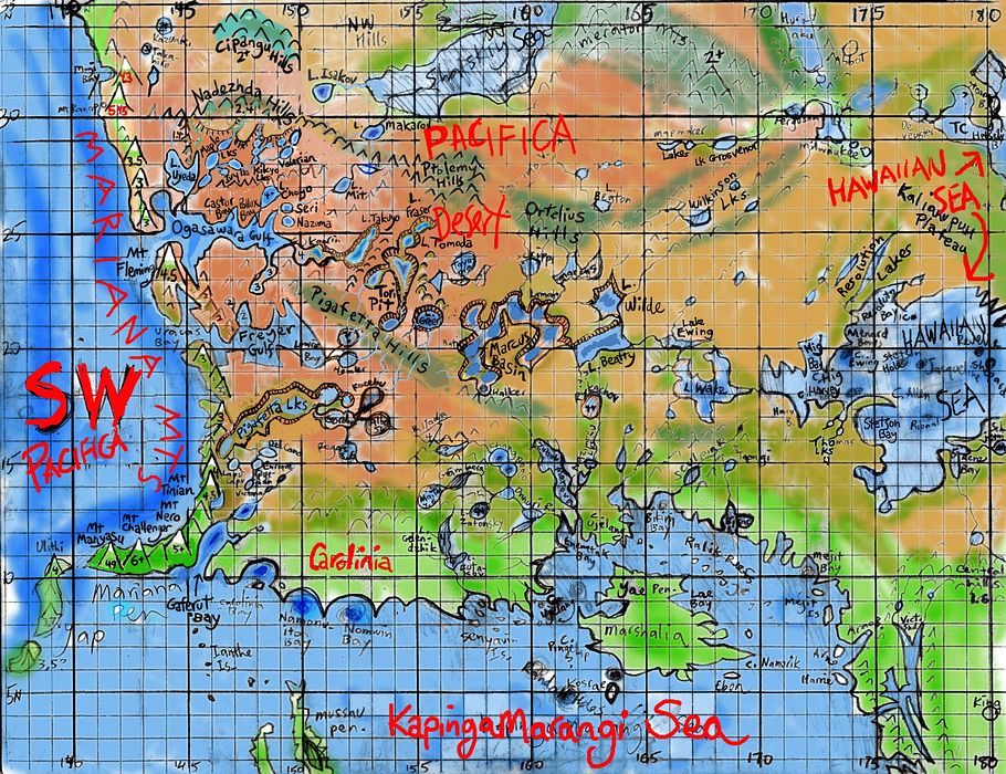
There may be a couple of bigger pits nearly as deep as Tori--sometimes. During the present era, with no ice at the poles, temperature, rainfall and sealevels are all at their very highest and Tori is the only sure bet, but the much bigger Marcus Lakes to the east, toward Lake Wake (our Wake Island--another very deep pit, but almost certainly waterfilled), may be a maze of winding sea-level mesas and salt-lake-dappled basins anywhere from 1 to 4 km down. I'm guessing they're not too sunken during this wet era--they'll get some rains off the Hawaiian Sea, and if its waterlevel is high enough, it'll spill over and fill the Marcus complex.
Overview -
Climates -
Pitted Desert -
Foxtaurs
-
Northwest -
Shatsky Basin -
the Marianas -
SW Coast -
Emperor Chain -
Western Is.

One more intelligent species may be native to this region--a mammal this time. The prairies east of the desert all the way to the Hawaiian Sea look ideal for foxtaurs, the intelligent, burrowing, playful child-sized omnivorous centauroid canines I postulate as a likely mammalian candidate for civilization in the the drier regions--mainly continental interiors, especially Pacifica's.
Eventually, I'll either expand this section, or write a dedicated page for foxtaurs, or add such a section to the tour of their heartland around the Hawaiian Sea coasts. But for now, the best description and sketches are in the foxtaur section of the Peoples of Abyssia page.
The relevance here, for the Pacific Southwest, is that while the foxtaur heartland is well to the east, a lot of the people and nearly all the mammals you meet out here in the western deserts will still be foxtaurs. They're better adapted to drought than most Abyssian mammals, they tolerate heat well, AND they've retained their ancestral love for burrowing. That's an advantage; in the Pacifican desert, a home whose walls and roof are half a meter or more of dirt or sandstone is thermally wise. Summer and winter both!

You'll find these little folk all over the hills and mesas from the scablands around the Resolution Lakes to the Ortelius Hills, west through the Ptolemies into the much higher Nadezhda Range and south through the many canyons draining those ranges--wherever cliffs and banks are exposed, so burrows are light and airy. Everywhere but the hottest, deepest pits.
Basically, foxtaurs are wherever Pitians aren't.
Most tourists find foxtaurs adorable--and foxes generally find exotic strangers equally fun to play with. I've had to put warnings in some other tours about getting too close to some Abyssian natives--a few of the larger flightless birds can be feisty, and have huge sharp beaks. Foxtaurs, however, are fairly safe to play with--sharp little teeth, yes, but they're calm people. Few natural enemies! They're snuggly people. So go ahead and touch.
But you'll notice that no one, no matter how friendly they seem, will invite you home. Don't feel hurt. You're a giant! You can only fit into their largest public burrows--the local music-inn, post office or cave-cafe.
Even there, mind the ceiling, or...
Overview -
Climates -
Pitted Desert -
Foxtaurs -
The Northwest
-
Shatsky Basin -
the Marianas -
SW Coast -
Emperor Chain -
Western Is.
There are some deep uncertainties here. Literally deep. The question is, how many kilometers deep?
The coastal mountains aren't uncertain at all. Some of the world's tallest! The Kuriles on the northwest coast are Alpine to Caucasian, topping out well over 5000 meters (near 17,000'). The lower slopes are pine and fir, thinning to meadows just 1-2 km up, and to barrens and ice by 3 (10,000'). Here you'll find nearly all of Abyssia's glaciers--this is it, except for a few polar islands like the Lenas and Scott off Antipodia--which the natives may not even have discovered. They certainly won't have decent inns, like the Kurile Coast! Tourist will flock here (literally flock in some cases, as I anticipate some intelligent species here will have functional wings), to see these scary wonders.
Scary? Well, yes. Abyssians will generally panic at the sight of snow. Nearly all the land is low- or mid-latitude, with gentle relief and maritime climates. Hard freezes just don't happen in civilized places! It's the end of the world!
It's possible that if you polled Abyssians from, say, Atlantis, or even Eastern Pacifica, a large minority might claim it's just a (literally) tall tale. Glaciers for sure, and maybe even these huge mountains themselves. "Travelers will say anything."
It should be noted that this really happened in the 19th Century, in America; many Easterners, used to strong seasons and low altitudes, simply scoffed at the stories of midsummer snow on the high mountains of the West; just another tall tale you can't put over on hard-headed me, no sirree! As flimsy as the one about steam-jets a hundred feet high roaring out of the ground. Right next to the skyscraper-tall trees, no doubt.
Not quite up there with climate-change denial--our well-informed world makes that less excusable, I think--but still impressive on the denial scale.
Abyssians have more justification still. There really are very few high mountains, and they're clustered tightly. Great swaths of the planet never see snow. And photography's either rare and expensive or nonexistent. Sketches like mine plus travelers' tales are all the folks back home will have to go by.
Still, the glaciers are there. A little slice of Earth. If Abyssians have a concept like our parks or preserves, the central Kuriles around Mt Vityaz and Mt Urup will almost certainly be one of the earliest. The Marianas to the south may be a little higher, but they're equatorial; ice won't have sculpted more than the summits. But the Kuriles will, to the Abyssian eye, look truly alien.
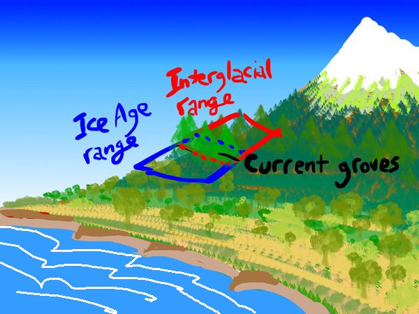
Speaking of tall-tale trees, skyscraper-tall... those abound on this coast too. Western Pacifica's the only place on Abyssia redwoods grow. The coastal species flourishes along a thousand-km strip from about 45° north down to 35, not so different from Earth's--just a bit farther north, is all. But the stubbier, longer-lived, more massive sequoias on the mountain slopes are much more extensive than Earth's. Not because Abyssians are saints who'd never log them--they do occasionally--but because here the primordial sequoia groves weren't groves, but a long continuous strip along the Kuriles' slopes, just one kilometer up on the knees of huge Mt Urup and Vityaz near Cape Simushin, two km up on the Japan Range south of Cape Ezo, and even the northern Marianas, where sequoias can be found as high as three km (10,000').
Why? Earth's sequoia range shrank to mere groves for a reason: each Ice Age and warm spell changes the altitude where sequoia sprouts survive, up or down. The groves we see are those that are just viable in both warm and cold phases of our crazy roller-coaster climate! A bit high & cold in Ice Ages, a bit hot & dry in interglacials, but they've hung on. If Earth stabilized, sequoias could spread over quite a wide range north and south, up and down. They just can't cope with fast climate change. They live too long!
It's an example of longevity's disadvantages. Stick around long enough, reproduce slowly enough, and you don't have to commit eco-crimes to experience disastrous climate change in your own lifetime. It just happens. (Though it takes a human to deny it while it's happening).
Anyway, Abyssia is blessed with a lot more sequoias as well as coast redwoods. This wide range plus low technology and slow shipping has meant logging hasn't made much of a dent; and even in modest quantities, this long-lived, rot-resistant wood has made the region prosperous.
But this rich Kurile coast and mountains are just a narrow strip. True, an influential strip: with much of the fertile land and population of the West, it has to be (just as it is in our North America).
Inland is another world.
Intro -
Climates -
Pits -
Foxtaurs -
NW -
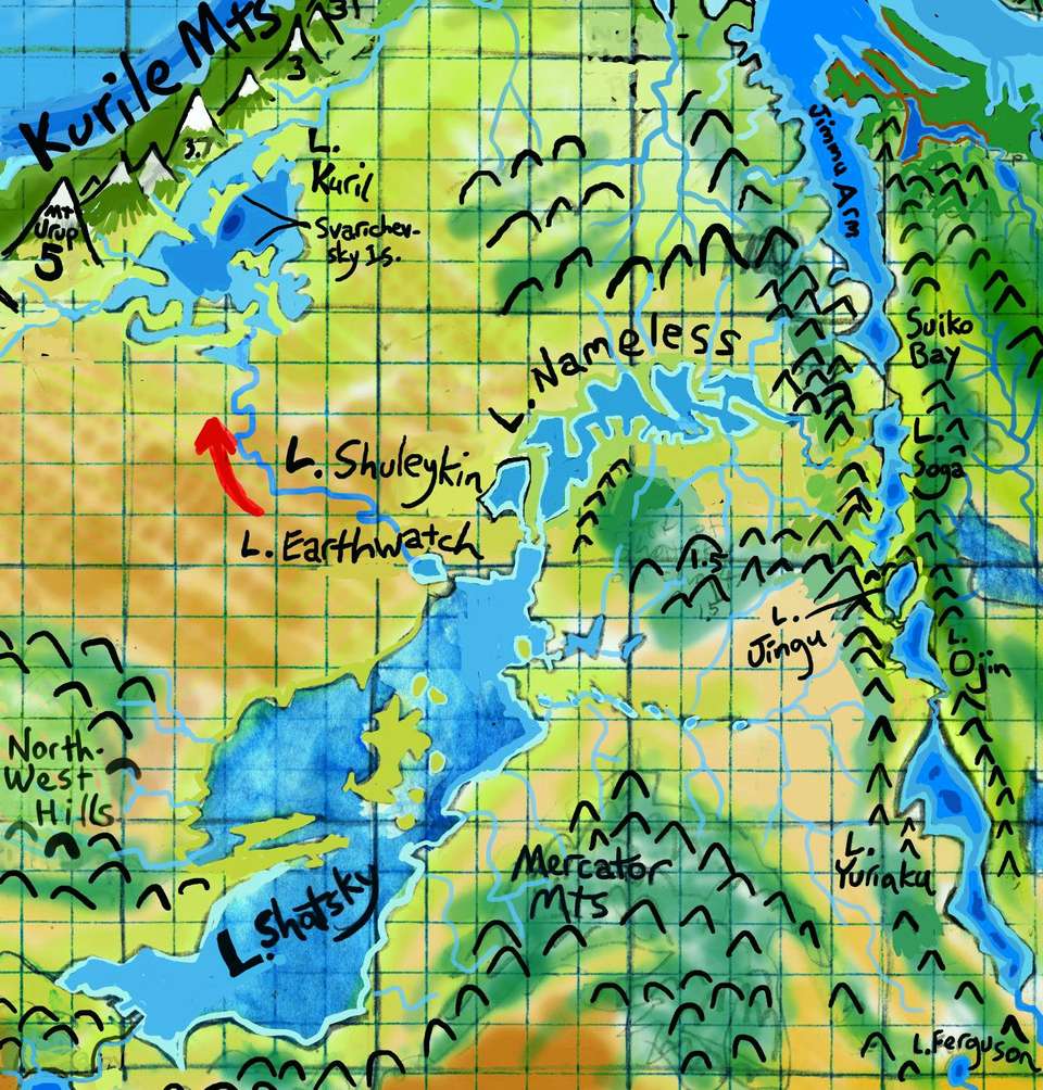
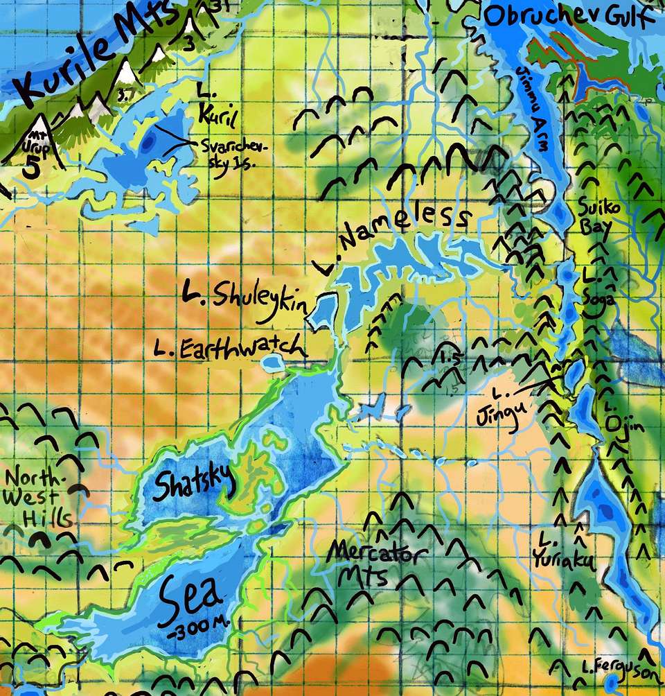
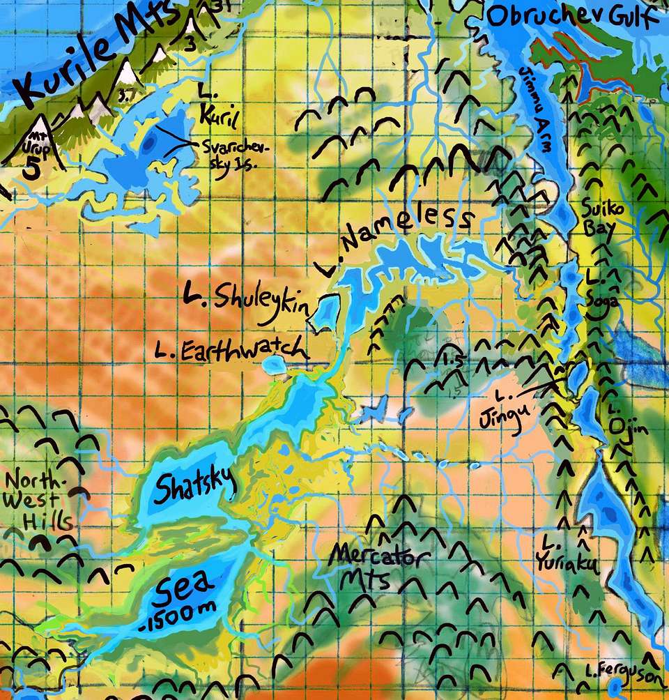
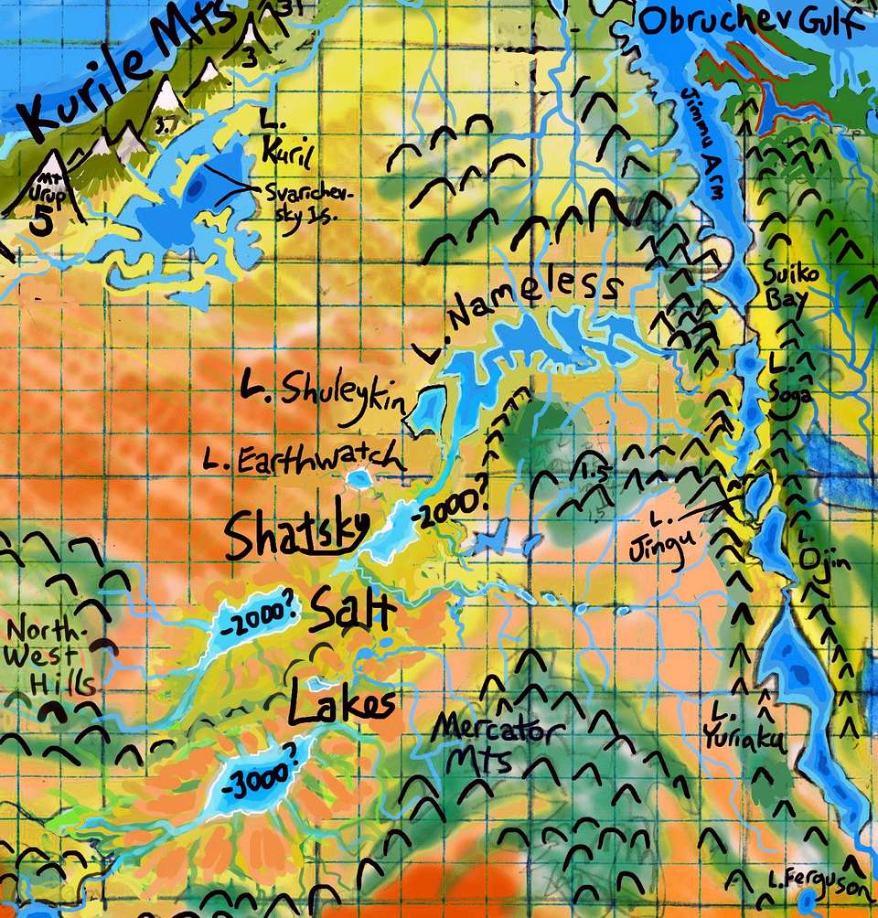
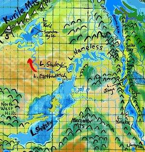
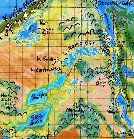
Shatsky Basin, Womb of the Revolution
-
Marianas -
SW -
Emperor Lks. -
Isles
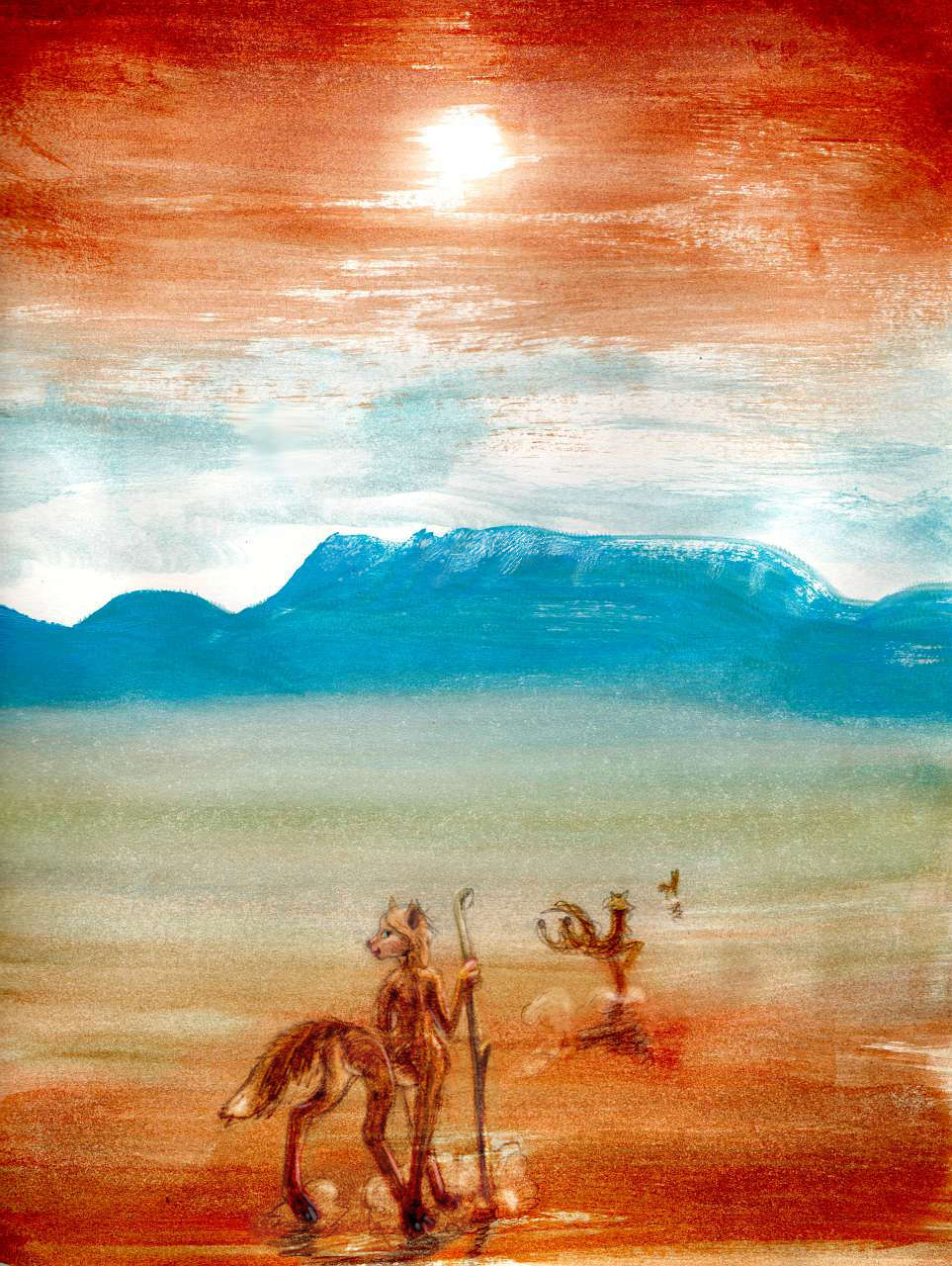
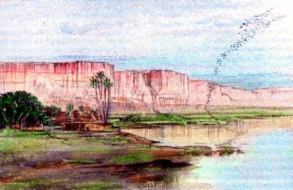
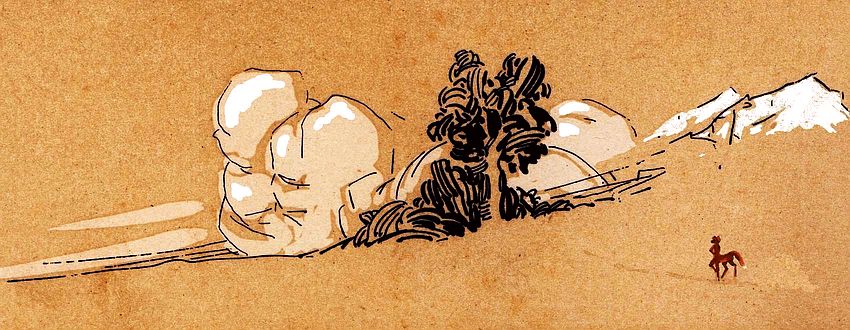
Vast low-lying shortgrass steppes fraying into true desert in spots. Rolling mountains--mere hills compared to the coast ranges, nearly all below 2 km high (6600'), but tall enough to wring some rain from the stingy winds, and snows in winter. Pine-clad islands in a prairie big as Canada's--or, and it's a better analogy, Central Asia's.

Foxtaur below piny Cipangu Hills, NW Pacifica; watercolor by Wayan
|
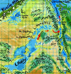
Just east of the great coastal ranges lies the long valley of the shallow, silty, braided Zenkevich River, some 3200 km long, running northeast from the Joban Lakes near Cape Boso to Lake Kuril (big as Lake Superior), then draining into Obruchev Gulf, the triangular inland sea at Pacifica's northern tip. Because flatboats (if not big barges) can make it up this river from the sea, this western edge of the great steppe will be its most prosperous and cosmopolitan.
The heart of the Shatsky Basin is uncertain: a depression as big as our Black Sea. Will it fill? Shatsky too is in the rainshadow of the Kuriles. The basin will have a very big lake, for sure, but how big, how fresh? What's around it? Semiarid prairie, or outright desert? It matters! If the basin fills, Lake Shatsky will be fresh and drain north (probably into Lake Kurile and the Zenkevich River, but just possibly--there's a gap in the eastern mountains--into Lake Nameless and on into Obruchev Gulf in the far north). Either way, a big freshwater lake will moderate the climate for hundreds of km all round, and with a river road to the sea, it'll be busy with trade ships.
If you're veterans of the East Pacifica tour, you know the story; the Hawaiian Ocean's the same. A canal linking it to the sea made all the difference between a cutoff Caspian fit for fishing and little else, and a Mediterranean full of shipping.
But if rainfall is scant enough, we'll have a lower, smaller, landlocked, saltier Shatsky Sea; cut-off seas have less stable shorelines, so salt or alkali flats may send dust over the plains, reducing fertility and heaping a chemical curse on the climatic curse. The curse of continental climate, I mean! A curse we take for granted. With our big, chunky continents, we're used to it. Abyssians aren't. No other land on Abyssia is as unbroken, as truly continental--so no other land has a climate quite so harsh--too hot AND too cold AND too dry. Locals will wonder what wrathful, annoying deity they offended, and invent bad religions with jealous gods.
Just hope they won't spread the way they have here! Probably not. They spread here courtesy of jihadis, conquistadors and missionaries backed by guns. But the inhabitants of this inland empire will be... foxtaurs. Hobbit-size people who worship good food, drink, sex, music, dancing and friendship.
So don't wait up for the foxtaur hordes sweeping out of the desert swinging swords. Just a trickle of foxes bored with the dust, signing on to caravans and heading for the coasts--out to see the big world.
On the other paw, or wing, Shatsky Basin is also as deep as our Black Sea, and if Shatsky's sea level is low enough, it's possible the air will be dense enough around its shores that pit-adapted life--fliers large enough to reach human intelligence--could survive, if not fly as easily as in the smaller but deeper pits to the south, like Lake Tori. Shatsky could be a colony--a halfway house where such big fliers, over generations, adapt to more normal air pressure--maybe, someday, being able to fly at sea level. With communications ten times faster than anything on land or sea, they'd conquer the world. Not militarily; these are fragile living fliers, not jet fighters--but how could states or trade networks relying on slow caravans or ships ever compete? So Shatsky matters. If the Sea exists, and is sunk deep enough to help Torians evolve this way, all Abyssia gains. Locals will wonder what deity they pleased, to make their scruffy bare country the nerve center of the world.
On the other other paw, the Northwest is huge, and two-thirds of it drains into Shatsky; while most is dry lowland, it's studded with ranges like the Mercators and Cipangu Hills, high enough (2+ km; 7000') to trap even scant rain. And the region's open to blizzards and storms from the north, for the hills of the Aleut Peninsula are much lower than the heart of the Aleut Range to the east. Further, some rain makes it over the eastern hills around the Emperor Lakes, from gigantic Lake Hess and the even larger Hawaiian Sea--these hills aren't the Rockies, and even the Rockies haven't starved the Great Salt Lake down to nothing.
L. Shatsky, draining NW
|
L. Shatsky, draining NE
|
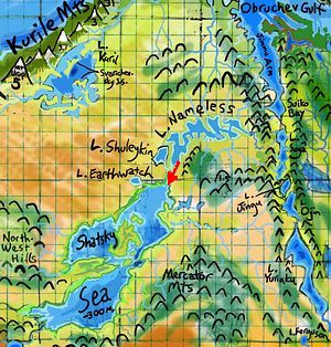
Shatsky Sea, brackish, 300 m. down
|
Shatsky Sea, salty, 1 km down
|
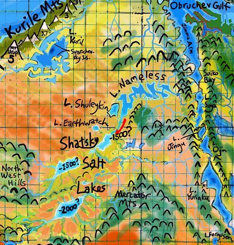
Shatsky Salt Lakes, salty to caustic, 1.5-2 km down
|
So my best guess is that with so many sources of runoff, Shatsky may be a freshwater lake the size of Texas, or a smaller cutoff sea, brackish but still very big and stable--the Caspian, not a deep-sunk Dead Sea. Like the Caspian, it won't be too far below sea level. So... not a colony of weird giant stressed-out birds unsure if they're flightless or not. More likely foxtaur country. Communication's not by winged courier but by caravan, on foot--though foxtaur feet are fleet.
But "best guess" among 4-5 options still isn't all that likely.
- 35% chance: Lake Shatsky, freshwater, big as our Black Sea. Busy with shipping, since its outflow reaches the ocean. Crewed by foxtaurs, the dominant people. No fliers.
- 25% chance: Shatsky drains into Lake Earthwatch, then in a winding Nile or Amu Darya across the steppes to Lake Kurile and north to the sea.
- 10% chance: Shatsky drains into Lake Nameless, then through a gorge into the Emperor Lakes--Lake Soga, north into Jimmu Arm of Obrachev Gulf.
- 30% chance: a brackish Caspian Sea just a hundred meters (or two, or three) below ocean level. Local shipping only, crewed by foxtaurs. Fertile shores, but a bit of a cultural hinterland.
- 30% chance: a large salt sea a kilometer or more below ocean level. Torians colonize, since they can (just barely) fly here; their descendants adapt, and can fly at sea level. Abyssia gains a fast news-and-airmail system, and becomes a unified world long before railroads and telegraphs made it possible on Earth. Without Blake's "dark satanic mills", too.
- 5% chance: a small, variable Dead Sea (or a couple of them) two km down, whose concentrated brine does not make for fertile shores. Torians still colonize in small numbers, adapt and radiate. All Abyssia gains. But Shatsky Basin is no more a hub of civilization than the Dead Sea is. Torian chicks with initiative all move out. The greatest export of this impoverished region is... delivery people.
This doesn't mean the odds that some intelligent species will fly on Abyssia is just 35%. The Torians have smaller pitlakes they can and almost certainly would settle, that could also function as halfway houses on their great climb out of the pits to sea level. Combined chance, 50-60%? And Pacifica's not the only place it could happen; in northwestern Agassiz another pitlake dweller, the Kurituk, has an excellent chance of making a similar evolutionary climb. I'd estimate the global chance of some intelligent sea-level flier evolving at 70-75%. In the other regional tours, I've assumed both Torians and Kurituks evolved.
More entertaining to sketch, after all.
Overview -
Climates -
Pitted Desert -
Foxtaurs -
Northwest -
Shatsky Basin -
Mariana Mts.
-
SW Coast -
Emperor Chain -
Western Is.
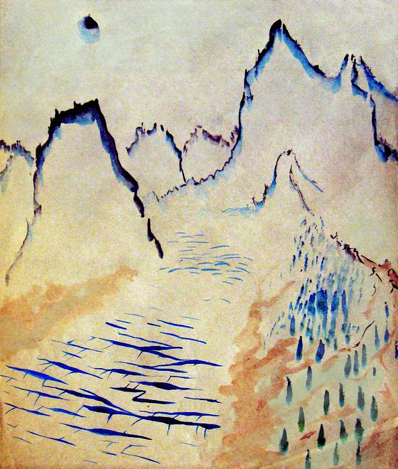
The Kuriles are impressive mountains, the most glaciated on relatively ice-free Abyssia. The iciest--but not the highest. For those, just sail another few weeks down the west coast.
At first the mountains, though still tall, forested, and snowcapped, dwindle steadily. Around Cape Ezo at 41° north, they're mere hills after the icy 5-km giants behind you to the north; half that height at most. Fertile hills, though--the lowlands and coast are scattered groves of oak (encouraged for their edible acorns and symbiotic truffles), bay laurel and their fruit-bearing cousins the avocado, domesticated here by foxtaurs long ago.
Inland, the modest peaks here are densely wooded--they still get plenty of winter snow (in fact, about the heaviest snowpacks in the world). But Erimo Pass, at just 1600m (a mile) is the lowest in over 1000 kilometers; snowfree most of the year. It's the gateway to the huge Shatsky Basin inland; caravans pause a few months in winter but Port Erimo does steady business.
Past Cape Ezo, the hills rise steadily again into true mountains: the Japan Range, tall as the Alps; the white teeth on the horizon look much like the Kuriles and are nearly as big. But we're visibly entering the southlands: the green, damp, misty north coast turns gradually golden, Californian as you round Cape Boso into warmer seas. At 35° north, the Cape, though modest, is a natural divider between northwest and southwest. From here on, the coast and mountains may or may not be green, but inland, the lowlands are true desert.
This stretch of the Mariana coast has a sunny Mediterranean climate. Snow here is not a season but a place you go. And you can go there, year-round; past Cape Boso the mountains, now the northern Mariana Range, grow steadily taller, creeping up to 5 kilometers high (16,500').
As we proceed south, though, the coast slowly gets drier--southern Californian, then North African. Trees retreat up the mountains, though a broad forested strip persists from one to three kilometers up. Palms behind the beaches, fruit trees only where irrigated along creeks... but still those ice-peaks on the horizon.

Mt Katsura, 4750m/15,600', from Mogi Bay, West Pacifica
Sketch by Wayan after 'Tomales Bay', a print by Tom Killion
|
|
Then the northern Mariana Range just... ends. A deep gash lets the sea into the low desert beyond. This sound, Ogasawara Gulf, wriggles hundreds of km into the hottest, driest desert on the continent. The current is steadily into the gulf--rainfall's negligable and evaporation's fierce. If it were cut off from the sea tomorrow, the Gulf would be a Dead Sea in few millennia and an alkali flat soon after. Beyond the Gulf, in the desert, just such pits yawn, kilometers deep, with hot, often alkaline saltlakes in their depths.
Your ship probably won't want to venture into the Gulf to trade; most of the cargo shipped out of this region is raw ore. A specialized trade, and a messy, sometimes toxic one.
Beyond the mouth of the Gulf, the central Marianas rise quickly again to 4500m (14,800'): Mt Fleming. Snow above the desert.
Beyond Fleming, the peaks are substantial but lower, irregular, and dry at their feet. The streams down from the highlands are modest; the region's only source of fresh water. Each creekmouth has a village; irrigated gardens and fishing boats.
While the land looks stingy, the fishing is phenomenal. The coast is dry because winds for much of the year are off the land; that blows surface water out to sea, and deeper, colder seawater upwells, rich in nutrients. These foxtaurs have to work for their food, both land and sea, but they live well.
Most years. As off Chile or Baja California, weather here is cyclic. In a bad year, the winds fail, the warm layers build up, and fish leave--or starve. Marine mammals do too, or they're poisoned by red tides. These reddish bacterial blooms in the warmer water make plankton toxic--and the fish who eat the plankton, and the big fish who eat them. Good thing this dry climate limits spoilage--the locals dry fruit, smoke fish and store nuts and seeds in good years, because red tides always come.
Foxtaur & seal killed by red tide, Mariana Coast, Pacifica; by Wayan, after Tom Killion's woodcut 'Dead Seal'
Around 20° north, a second great gap opens in the mountains. A second great gulf--Uracas Bay and Freyer Gulf. Like Ogasawara, this complex is an inland sea as large as our Gulf of California, and equally rich--underwater. But the shores, behind the Mariana Range, are hot, barren and harsh--Baja again, or worse--the Red Sea shores? One difference: the mountains on both sides of the mouth of Uracas are quite high, topping 3 km (10,000'), with sparse, lightning-scarred forests on their shoulders. These heights squeeze every drop out of the winter rains and summer thunderstorms; annual rainfall in the lowlands is often zero. Only the occasional canyon with a snowmelt creek is really habitable.
Foxtaur views desert canyon north of Uracas Bay with Mount Fleming on horizon, Mariana Coast, SW Pacifica
From 15° on south, though, things improve. The shores are still rather dry for hundreds of km, but the peaks of the South Marianas always catch enough rain even in this dry land to send a river down every few dozen miles. They're getting taller, too--back up toward 4 km or more (13-14,000'). There are dense forests up there--a sponge for rain, a reserve in the dry season.
Also, the coast begins to green a little. We're entering the monsoon belt now. Winter rains are negligible (at sea level) but summers get so hot that thunderstorms become a significant source of rain. Grass and scattered trees along this shore, even away from creeks; it looks vaguely African.
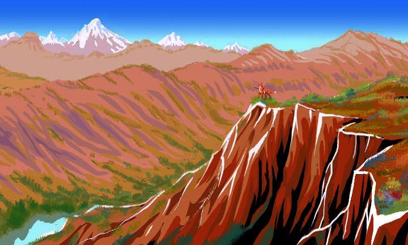
As we near 10° north, the mountains grow even taller. The coast swings west. You can't see it--a wall miles high is in your way--but there's no desert on the back side now. The southernmost Marianas are a peninsula winding into open sea, getting rainstorms from both sides. No dry side! Forest lines the shore. Dense green cloud-forests up the slopes, climbing nearly 4 km up--and that's only to the shoulders of the peaks ahead. White streaks of waterfalls. Above the clouds, fern-fells This is the climax of the great range; Mt Nero rises well over 5 km (17,000'), high enough for glaciers, here nere the equator. Beyond stands the real monster: Mt Challenger, tallest mountain in the world at 6120 meters (20,100'), comparable to Mt Denali on Earth. With one difference: it rises directly from the sea. Base to top, is any peak on Earth that tall? Maybe a few Himalayan peaks like Nanga Parbat, Annapurna and Dhaulagiri come close. Certainly not Everest. Very few.
From glacial horns to mango trees and tropical beaches in twenty miles. A fine place to rest after a long hard trip. Though your ship will head on round Cape Mariana to...
Overview -
Climates -
Pitted Desert -
Foxtaurs -
Northwest -
Shatsky Basin -
the Marianas -
The Southwest Coast
-
Emperor Lakes -
Western Is.
Foxtaur and palms, Bikini Bay, Southwest Pacifica
after Tom Killion's print "Palisades Park, Santa Monica"
|
The Pacifica Desert is big, and hot--very hot, down in the pitlakes. But the southern shore of Pacifica strays outside the dry zone; it's monsoon country. Warm and dry winters, but rainy summers--usually. Inland, the rains get steadily less reliable, the pitlakes more sunken.
But near the coast--a strip called Carolinia--lakes brim over and rivers actually flow to the sea--at least seasonally. This gradient of true- and seasonal- and occasional- and ghost-lakes vaguely resembles Australia's Nullarbor Plain. But it's more complex: broken and hilly, and the hills snag clouds and rain; they're often wooded.
The result is a narrow coastal strip that's green year-round, with irregular tongues of very hot, relatively fertile lowland savanna and rocky but wooded highlands reaching hundreds of kilometers inland--though all of them do fade at last into scrub and true desert dotted with pitlakes and canyons well below sealevel, making the Dead Sea look lush.
The coast is pleasant in the dry season; but the summer rains are pretty relentless. To escape, many of the locals (a mix of mostly foxtaurs and kasowars) move inland. The rains make it here too, though they're lighter. Brief paradise, as the savanna greens! A month or two after the rains fail and the thermometer starts rising (along with the dust!), as the rivers sink back to pools, folks head back out to the coast. They take their time on the muddy roads; the monsoon forest's slowly ripening fruit and nut crops. In the mild dry days of midwinter they're ready for harvest.
Neither quite nomadic or settled, coastal or inland, these people have two true homes--summer and winter.
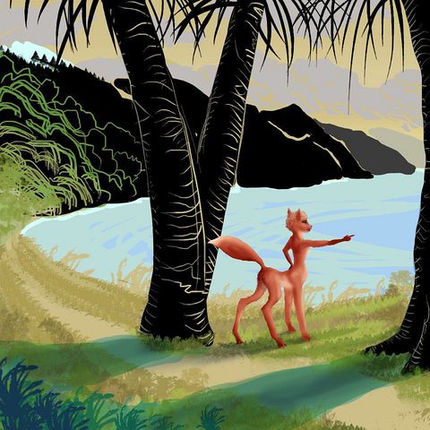
Off this coast are even greener islands, cycling between hot rainy summers and a milder but not bone-dry winter--a rather Hawaiian pattern. The western islands, the Ianthe Chain, are low-lying and small, none over 20 km long. These lead far offshore to the Vityaz Archipelago, a complex so large it merits its own page. To the east are the larger but coast-hugging Senyavin Islands.
Farther east and offshore, dominating the Kapingamarangi Sea, is Marshalia, a green island some 800 km long and over 400 wide; bigger than Java, with Hawaii-sized satellites like Kosrae and Ebon. At just 5-10° north, Marshalia should be wet year-round, the region's only true rainforest; but the sheer size and aridity of Pacifica just to the north makes winter rains anemic. Still, the monsoon woods in the hills are dense--perhaps a fourth of southwest Pacifica's biomass is concentrated on this one island! Rivers don't fail, even in the dry season; trees provide fruit and shade; and the sea is rich. Not a bad place to live.
These folks don't bother migrating.
Overview -
Climates -
Pits -
Foxtaurs -
NW -
L. Shatsky -
Marianas -
SW -
Emperor Lakes
-
West
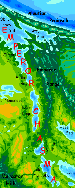
In the very center of Pacifica, not properly fitting into any region, are the Emperor Lakes. They're a long set of guyots, which on Abyssia means a very deep but flat-bottomed lake--the inverse of a flat-topped seamount, the word's meaning on Earth. This long lake-chain is flanked by hills, mountains in places (2-3 km, 7-10,000'); a natural boundary between east and west Pacifica. It looks, more than anything, like a rift valley! It's not, if Earth is any guide; in our world it's the trailing end of the Hawaiian chain; old, eroded seamounts whose great weight has bowed down the surrounding sea floor. What might cause the reverse of such a feature on Abyssia is unclear. What does anti-vulcanism even mean?
Though any exogeologist who's studied Venus wouldn't hesitate to call the Emperor Valley a "chasma". Riftzones much like this crawl all round Venus. I swear someone turned that planet inside out like a sock.
Culturally, the Emperor Valley is split. The northern half--Jimmu Sound and Suiko Bay, and long freshwater Lake Soga--looks to the sea; like the Zenkevich Valley, it drains north into Obruchev Gulf and is accessable by trade ships; its culture will be largely maritime, with large flightless birds predominating.
Hills a mile high cut off the southern half--Lakes Jingu, Ojin, and Yuriaku drain south into the Hawaiian Ocean, heartland of the foxtaurs. So the boundary runs deeper than racial (subspecies) or even species; here it's between the feathered, highly visual, rather formal worldview of birds, and the more multisensory (sight, yes, but sound, smell and touch too), furry and indeed rather, well, fuzzy worldview of mammals.
It's not an opposition. The two worlds interpenetrate all over Abyssia, with avians dominating islands, mammals dominating continental interiors (mostly). The line here in the Emperor Chain is just unusually sharp. Climb the pass, stay at one of the inns, and the next day in a single hour you can walk out of--well, not exactly Earth, for the mammals here are centauroid, but a recognizable Earth just the same--over the pass into a world rather like our Age of Dinosaurs.
Small, polite, feathered ones, it's true. But confident in a way few birds on Earth can afford to be.
Mercator Mts by Emperor Chasma, central Pacifica; by Wayan after ink sketch by Katherine Sturges Dodge c.1915
Overview -
Climates -
Pitted Desert -
Foxtaurs -
Northwest -
Shatsky Basin -
Marianas -
SW Coast -
Emperor Chain -
Western Isles
The great island-cluster of Filipinia (fully ten times the size of our Philippine Archipelago) lies to the west, with satellite archipelagoes stretching another couple of thousand km; next to anything but huge Pacifica, the Filipina complex would look continental.
Whatever we label Filipinia, it's big, fertile, and complex enough to deserve its own page.
 TOURS: this route snakes around Abyssia's major lands -
Lena Is. (brr!) -
Greek Is. -
Atlantis -
Azorea -
Cayman and Albatrosia -
Andean Is. -
Scotia Is. -
Morningtonia -
Agassiz -
South Pacifica -
East Pacifica -
Hawaiian Sea -
Pacifica Desert -
Filipinia -
Banda Is. -
Vityaz Archipelago -
Tasman Is. -
The Bight -
Whartonia -
Chagosia -
Somalia -
Mascarenia and Crozetia -
Weddellia -
Argentia -
Pernambuco -
Angolia -
Tristania -
Agulhas group
TOURS: this route snakes around Abyssia's major lands -
Lena Is. (brr!) -
Greek Is. -
Atlantis -
Azorea -
Cayman and Albatrosia -
Andean Is. -
Scotia Is. -
Morningtonia -
Agassiz -
South Pacifica -
East Pacifica -
Hawaiian Sea -
Pacifica Desert -
Filipinia -
Banda Is. -
Vityaz Archipelago -
Tasman Is. -
The Bight -
Whartonia -
Chagosia -
Somalia -
Mascarenia and Crozetia -
Weddellia -
Argentia -
Pernambuco -
Angolia -
Tristania -
Agulhas group
Abyssia's homepage - map - peoples - regional tours - names
LISTS AND LINKS: More worlds? Planetocopia! - dreams of other worlds - ecology - climate change - evolution - natural disasters - terraforming - sculptures and 3D art -
World Dream Bank homepage - Art gallery - New stuff - Introductory sampler, best dreams, best art - On dreamwork - Books
Indexes: Subject - Author - Date - Names - Places - Art media/styles
Titles: A - B - C - D - E - F - G - H - IJ - KL - M - NO - PQ - R - Sa-Sk - Sl-Sz - T - UV - WXYZ
Email: wdreamb@yahoo.com - Catalog of art, books, CDs - Behind the Curtain: FAQs, bio, site map - Kindred sites