World Dream Bank
home -
add a dream -
newest -
art gallery -
sampler -
dreams by
title,
subject,
author,
date,
places,
names
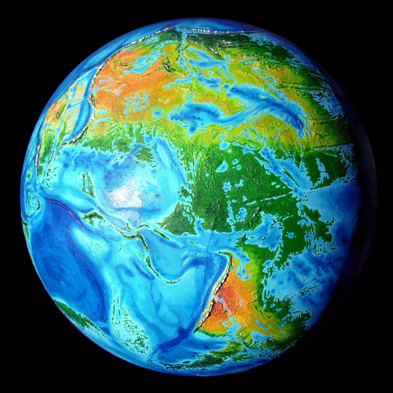
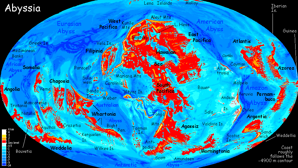
Abyssia:
Scotia Archipelago
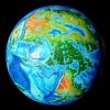

by Chris Wayan, 2004
for William Beebe and Otis Barton, first voyagers into the abyss
Abyssia home - down to
map -
building Abyssia -
geology & geography -
critters & cultures -
the clash of names -
more worlds? Planetocopia!
Introduction
-
Sandwichia -
the Yaghans -
the Orkneys -
Shetland -
the Natives -
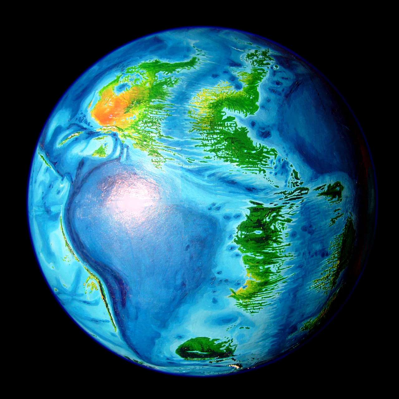
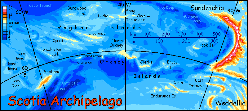
Cartographic Note
The Scotia Archipelago is part of a whole ring of islands and small continents around the Antarctic Sea--the coldest lands on Abyssia, though that's not saying much by our Earth's standards; though winter snows can admittedly linger in the far south from April to November, they're all habitable and ice-free--not a Greenland in the bunch.
The islands of Scotia exist in our world too, if not in exactly the same spots--impossible by Abyssia's premise. But our Scotia Sea between Patagonia and the Antarctic Peninsula is a small plate with vigorous tectonic action on three sides, guaranteeing great mountains and trenches side by side. South Georgia, the South Sandwich Islands, the South Orkneys, and South Shetlands (are you detecting a trend in names here?) all become deeps, of course, on Abyssia; but not to worry! Up come the neighboring trenches. So welcome to Shetland (not south Shetland; Scotland and our Shetlands are a deep abyss, trust me!), the Orkneys (ditto), and the long Yaghan Islands. They're a lot pleasanter than our near-Antarctic islands, let me tell you.
 Why? Both Abyssia's poles are warmer than Earth's. CO2 levels are no higher than ours, but Abyssia lacks land at the poles to build up substantial icecaps. The height of our polar ice-domes, not just their latitude, cools their tops to near-Martian temperatures; winds off these icefields spread cold dry air, cooling the climate for thousands of km around them. Without these dubious gifts, the Abyssian poles are much milder. Though winter sea-ice is extensive, it's less than a meter thick and melts entirely each summer.
So the Scotia Archipelago is better-named on Abyssia than our world. The isles of our Scotia Sea are wretched, windy, barren, icy--but these Abyssian islands are densely forested and quite livable. Cool and rainy most of the year, snowy in winter, but with pleasant summers. Quite Scottish, really.
Livable for Terrans at least. But the fauna of Earth, with its broad subpolar lands and a history of ice ages, has a long familiarity with cold. In contrast, most Abyssian land, and life, is subtropical or tropical; only this Southern Ring has long snowy seasons. Many Abyssian lines may not have evolved to tolerate freezes; what we'd call "temperate" zones are a harsh, minor niche here.
So the Scotias may be a hinterland not just from isolation but simply because Abyssians can't easily exploit it. After all, even humans, long adapted to wearing stolen furs and playing with fire, still find little to eat in evergreen forests; hunting, herding or clearing the land laboriously for summer gardens aren't easy even for us, and may be even harder for Abyssians. Until we know what they evolved from, we can't be sure. Perhaps they have natural coats that limit their use of clothing, limiting them to warmer climates; perhaps they aren't carnivorous and expect to cultivate fruit trees and nest in them; perhaps they require meadows to graze in, or are too lightly built to easily clear natural groundcover to farm.
In any case, this strange and rare (for Abyssia) ecology will likely be sparsely populated; while the fishing's unquestionably rich, land-life here won't be easy.
Except seasonally. It's possible Abyssians will fly, though not as likely as on some other worlds postulated here in Planetocopia. If so, some Abyssians may be migratory; Scotia might be their summer garden and playground, even a nesting ground for the Argentians to the northeast. A fast-growing garden, with such long summer days! Not a midnight sun--we're only 50-60° south here--but short nights.
There's another possibility, though, if Abyssians fly. The Scotias are a vital link in the southern flyways--they not only complete the Southern Ring, they're a bridge between hemispheres: Pacifica and Agassiz (most of the world's land) and the Atlantis complex (the dozen small continents created by the Atlantic Rift Zone). The Asian Ocean separating them is as vast as our Pacific, and quite islandless. No migratory stepping stones at all. And the flyways to the east, over the American Ocean, are nearly as hard--a few more islands, but some long, exhausting flights. But here in the south, the hops between islands are mere hundreds of km, not thousands.
So the Scotias may be overrun each summer by trans-hemispheric travelers.
Intro -
Sandwichia
-
the Yaghans -
the Orkneys -
Shetland -
the Natives -
Cartographic Note
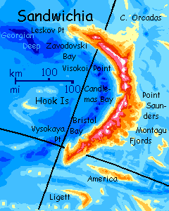
Sandwichia is that curving, savagely mountainous island at the east end of the Scotia Sea. It's rising on its own tectonic platelet and may be slowly forming its own continent. Simmering with volcanoes that build as high as anything in the hemisphere, dumping ash into the increasingly shallow sea to the east, Sandwichia's certainly trying hard, and may, in a few million years, succeed.
Sandwichia now has its own page.
There's a new if lonely archipelago about 200 kilometers west of Sandwichia: the Hook Islands. I only recently discovered their corresponding deep on Earth in a regional chart from GEBCO, the General Bathymetric Chart of the Oceans. Hook itself is 50 km long and 10-15 wide (30 by 5-10 miles). Hills are low, unlike most in the Scotia region, but still enough shelter for low woods on the sunnier, more sheltered north slope. The lesser Hooks to the north are so low and windy they're treeless. Unlike nearly all other names in the Scotia region, I can't find any named features at all near it--sadly, no Captain Hook discovered it or ran aground here. The name's just from its fish-hook shape. Small though they are, the Hooks may be busy: they're situated to make a fine resting place on the otherwise long tedious flight from Sandwichia to the lesser isles of Scotia to the west, such as...
Intro -
Sandwichia -
The Yaghans
-
the Orkneys -
Shetland -
the Natives -
Cartographic Note
The warmest. Also the largest archipelago, 640 km long (400 mi) from Black Island to Shackleton Bank in extent if not area; Quest and Endurance are 125 km long (75 mi), but narrow; and the rest are small. At 53-58° south, they're definitely Scottish, not Siberian. All the Yaghans are long, roughly east-west ridges--everyone will live on the pleasant north shore, facing the sun and sheltered from blizzards. These microclimates may even be more English than Scottish. In any case, nothing like the relentless, icy Antarctic winds of our Earth, blasting the Falklands/Malvinas! Polar and gentle aren't words we often link, but that's due to our polar icecaps--those dying relics of our Ice Age. Abyssians never heard of such things, and would applaud our civilization for its heroic attempts to melt our caps and re-establish a sane climate--though of course the price may be a little inconvenient flooding... Anyway, while the Yaghans are high-latitude by Abyssian standards, they're also gentle for that latitude. Not a bad place to live.
Intro -
Sandwichia -
the Yaghans -
The Orkneys
-
Shetland -
the Natives -
Cartographic Note
The Orkneys are really two chains. The North Orkneys are deceptively named. They're all at or beyond 60° south. Still, they're within flying range of the Yaghans and are a logical path for trade and travel between Weddellia and Morningtonia. With shallows to the north and a deep trench to the south, I project rich and varied fishing, too. As in the Yaghans, the north shores are the place to be; much warmer.
The South Orkneys or Endurance Islands are still forested and habitable, but smaller and colder. They're the last gasp of the continental platform of Weddellia to the east. I'm afraid the smaller isles here won't see many outsiders. There's a reason for the word insular and the South Orkneys exemplify it. One exception: Fliers from Weddellia will use the largest of the South Orkneys, Barth, as a stopover on the way to the North Orkneys and Yaghans, and then, as the Scotian saying goes, "Second star on the left, and straight on to Morningtonia".
Intro -
Sandwichia -
the Yaghans -
the Orkneys -
Shetland
-
the Natives -
Cartographic Note
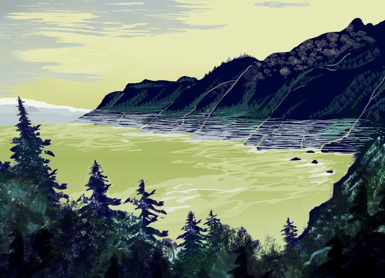
Shetland's one of the larger Scotias, a good 160 km (100 mi) long and half as wide, and certainly the most scenic--its craggy backbone rises at least a kilometer, in a spiny crest like a dimetrodon. It's not just dramatic: that great rocky spine means the northern, sun-facing side will be warm and sheltered, despite the latitude (61-62° south). The population's almost entirely coastal and mostly northern, up against the Sunwall, as it's called. Some fishing villages on the south shore do just fine, but there's little between the two coasts but empty scenery: the Highlands are windy and soils are thin.
 Shetland's the Scotian isle nearest to mainland Morningtonia, the small continent to the west. You'd think Shetland would thus be a major port, whether air- (if Abyssians fly), or ship- (if they don't). Unfortunately, it's isolated from the rest of the Scotias--well south of the Yaghans, far west of the Orkneys. So traffic will flow to the north, from Morningtonia to the Yaghans, then the North Orkneys, and on to either Sandwichia or Weddellia, bypassing Shetland. Insularity again!
So at this moment, I may have no idea yet how the locals will look--great auks, centauroid muskoxen, wooly mini-mammoths--but I'm sure how they'll sound--some insane Scots burr so thick and thornily local that no one else, even Orkneyans or Yaghans, can grasp a word.
And Shetlanders are proud of it.
Intro -
Sandwichia -
the Yaghans -
the Orkneys -
Shetland -
The Natives
-
Cartographic Note
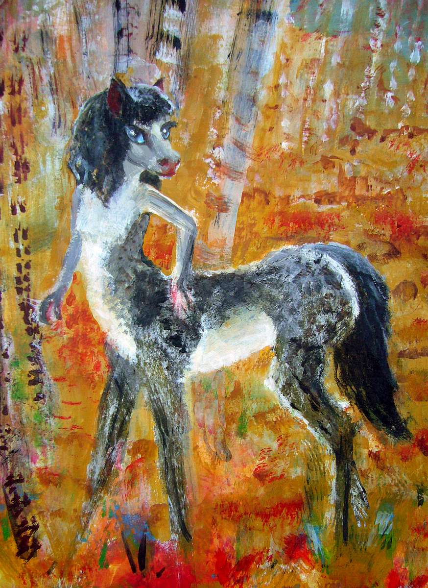
Who are the Shetlanders? Why, Shetland ponies, of course! Well... sort of. Scotians are a mix of two wildly different species, and one does, vaguely, resemble a Shetland pony--at least, they're smallish equines I'm dubbing "the equi" (since we can't go calling them, as they do themselves, the "Houynhm". I'm not trying to spell that. Or even say it.)
Anyway, these equi are smallish (deer- not horse-size) centauroids--small forearms but dexterous hands. Paws not hooves--these aren't horses. But the general build, manes, ears and tails all look quite equine, so let's not be fussy. The equi.
They don't even have the decency to look consistent. They vary tremendously from island to island--not THAT many travel and marry off-island. Those seas are cold, deep and often stormy. So, depending on the island, equi range from gracile to massive and from long horselike faces to much shorter-faced individuals, almost feline (or human) in proportion. Even on a single island, Shetland, there's a wide range.
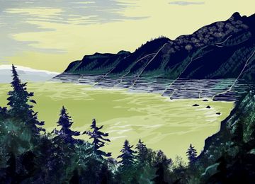
Here's a paint-sketch of an eq couple on their farm on Shetland in the fall, in a clearing amid aspens.
Aside from very general coloration, they look like different species--at least as different as bonobos and chimps.
Well, part of that is my painting style. Cartoony. Sorry! Even in paint, I'm a caricaturist at heart. I may have physicalized my emotional impressions--he was a quiet outdoorsy type, so I painted him as a long-jawed wild creature, while she was a sociable, purring housecat, so I painted her as more feline than she undoubtedly was.
Such symbolic, characterological symbolism is hard for me to escape--plenty of readers have commented on it--but this really is how I see even the people of Earth--as strange dreamlike caricatures that nonetheless encapsulate their moods, characters, souls. A legacy of Asperger's I suppose; the same syndrome that lets me code at the speed of English also means I live in a floating world of spooks, signs and symbols. I don't find it creepy, it's home to me. More Krazy Kat than Basquiat! But certainly not what most of you (by all reports) see. I do try here.
As I fingerpaint...
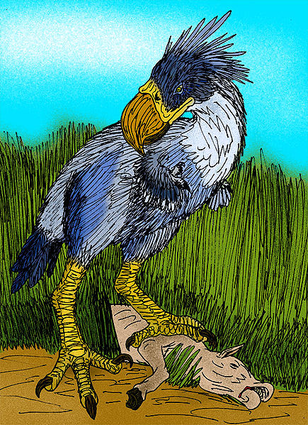
The other species present in the Scotias, the Bronts, aren't cute by any standard, not even mine. Huge, fierce, flightless birds from Sandwichia. They make poor sailors--having evolved for hunting they have massive, unbirdlike, unbreakable solid bones that drag them down in seawater like anchors.
Just don't fall overboard, right? Except... these are rough seas to navigate, remember. Bronts get seasick too. A whole crew of hulking velociraptors puking roast porktaur onto your head is not a pleasant thing. And worse if they lean too far, and go over. Even a Bront clinging to a spar lasts about ten minutes in this chill sea.
So the Bronts have settled only the isles nearest to Sandwichia--the South and East Orkneys. No more than 50 km (30 mi) from island to island. An hour or three of torture. But the North Orkneys and the Yaghans require passages of 100 km or more, and Shetland, 200 (up to 125 mi).
So far, very few bronts have ever taken passage in ships with equi crews to reach the outer Scotias, and none have founded families.
Intro -
Sandwichia -
the Yaghans -
the Orkneys -
Shetland -
the Natives -
Cartographic Notes
Hi. It's 2021, and I'm remapping this region a bit, using more accurate charts from GEBCO, the General Bathymetric Chart of the Oceans. Details have changed:
- Shag Island has shattered into Tehuelche, a much smaller Shag, and Black Island
- The Orkneys have moved (and narrowed, and changed shape)
- A new island has appeared west of Sandwichia, which for lack of any better name I'm calling Hook, based on its shape, or perhaps a certain pestiferous captain
- Ushuaia is now Quest (though its shape is still probably wrong--it may be just another straight ridge or line of islands)
Indeed the locations and shapes of all these islands are still quite sloppy--I'm confident the archipelagoes exist, and their rough locations, but little more. I just don't have the energy to pin them down definitively, when all my resources disagree--it's a stormy, dangerous, poorly charted region of Earth, and my own wretched cartography partly reflects that. Even the update is one of my worst maps.
Still, incremental improvements do add up--eventually. After the appalling setbacks here in America in 2020, that's all the consolation I can offer. Sigh!
Keep building. Maybe we'll build things faster than thugs can tear them down. If not, at least we're builders.
Well... now it's 2022, and I've revised these islands--moved, changed size, or renamed nearly every one. Sandwichia's still a mess on the main map, but at least the detail-map is updated.
 TOURS: this route snakes around Abyssia's major lands -
Lena Is. (brr!) -
Greek Is. -
Atlantis -
Azorea -
Cayman and Albatrosia -
Andean Is. -
Scotia Is. -
Morningtonia -
Agassiz -
South Pacifica -
East Pacifica -
Hawaiian Sea -
Pacifica Desert -
Filipinia -
Banda Is. -
Vityaz Archipelago -
Tasman Is. -
The Bight -
Whartonia -
Chagosia -
Somalia -
Mascarenia and Crozetia -
Weddellia -
Argentia -
Pernambuco -
Angolia -
Tristania -
Agulhas group
TOURS: this route snakes around Abyssia's major lands -
Lena Is. (brr!) -
Greek Is. -
Atlantis -
Azorea -
Cayman and Albatrosia -
Andean Is. -
Scotia Is. -
Morningtonia -
Agassiz -
South Pacifica -
East Pacifica -
Hawaiian Sea -
Pacifica Desert -
Filipinia -
Banda Is. -
Vityaz Archipelago -
Tasman Is. -
The Bight -
Whartonia -
Chagosia -
Somalia -
Mascarenia and Crozetia -
Weddellia -
Argentia -
Pernambuco -
Angolia -
Tristania -
Agulhas group
Abyssia's homepage - map - peoples - regional tours - names
LISTS AND LINKS: More worlds? Planetocopia! - dreams of other worlds - ecology - climate change - evolution - natural disasters - terraforming - sculptures and 3D art -
World Dream Bank homepage - Art gallery - New stuff - Introductory sampler, best dreams, best art - On dreamwork - Books
Indexes: Subject - Author - Date - Names - Places - Art media/styles
Titles: A - B - C - D - E - F - G - H - IJ - KL - M - NO - PQ - R - Sa-Sk - Sl-Sz - T - UV - WXYZ
Email: wdreamb@yahoo.com - Catalog of art, books, CDs - Behind the Curtain: FAQs, bio, site map - Kindred sites