Abyssia:
Somalia
by Chris Wayan, 2006-2011
for the much-abused citizens of Earth's Somalia
Abyssia home - down to map - building Abyssia - geology & geography - critters & cultures - the clash of names - more worlds? Planetocopia!
Abyssia:
Somalia
by Chris Wayan, 2006-2011
for the much-abused citizens of Earth's Somalia
Abyssia home - down to map - building Abyssia - geology & geography - critters & cultures - the clash of names - more worlds? Planetocopia!

Welcome to Somalia - Amirante - Outlying Isles - Creatures and Cultures
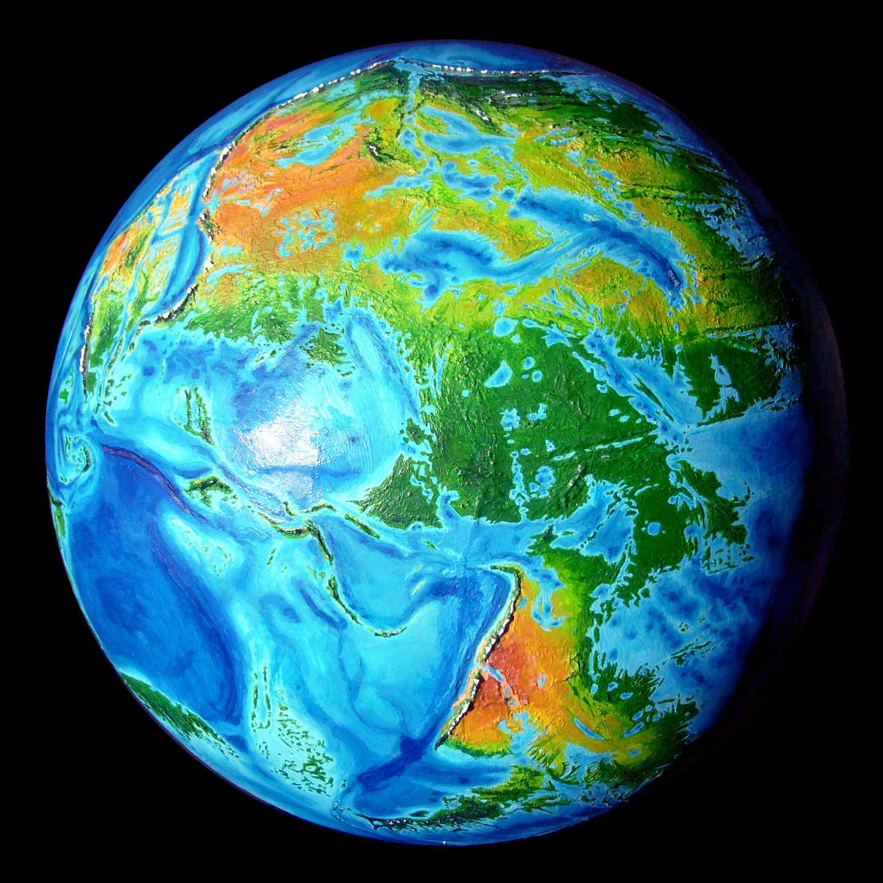
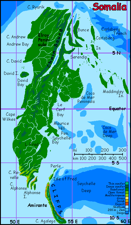
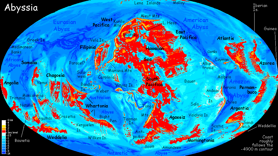
Size & Location
On Abyssia, Somalia is a minicontinent or very large island (over a million sq km, or 400,000 sq mi; bigger than New Guinea; comparable to France plus two Great Britains). It rises southeast of our Somalia; its equivalent on Earth is the floor of our Arabian Sea. The island is equatorial and quite rainy--forest coast to coast. Islands surround it, north, east and south; to the west is the islandless African Abyss. Even where island chains reach toward nearby landmasses, there are gaps of many hundreds of kilometers; settlement by sea won't be casual or early. More New Zealand than Australia.
Topography
Well... not much! Mainland Somalia is low--all flat or rolling hills. Not a single peak on the mainland tops 1000 m (3300'), and even 500 (1600') is rare. Rivers are sluggish and winding; at the height of the rainy season, much of the lowland forest floods.
Long ridges do parallel Chain Sound in the north, and fuse to form a low divide in the south. But the only places in the region with mountains of any height are Somalia's satellite islands--Owen in the north and Amirante in the south are both quite rugged, with steep ridges up to a 1500 m (5000'). The same is true of Vema Island far to the southeast. In this region, a fork of the Indian Rift curves around Somalia, running north, then west, then south again (our East African Rift), nearly meeting itself, and creating both great heights and depths. Somalia's mainland is the relatively undisturbed eye of this geological storm.
Climate
Abyssia's Somalia is climatically very unlike Earth's. Located further south than our Somalia (straddling the equator) and without Earth's great deserts near it, this Somalia is nearly unbroken rainforest--more Congolese, Papuan or Amazonian than like our own semi-arid Somalia. Palm trees on the coast, mixed hardwoods inland--dense forest up to 60m high (200').
But most of the mainland is so equatorial it's rainy year round. In the far north, summers are rainy but winters seem some long dry stretches. The woods on northern Elroy Peninsula do open up a bit, especially on the drier western slopes of the Chain Hills. And in the far south around Capes Revelle and Alphonse, there's a dry season again, out of phase with the north. Open woods and even a few meadows here, on the drier west side of the hills.
The dry season is even more noticeable on...
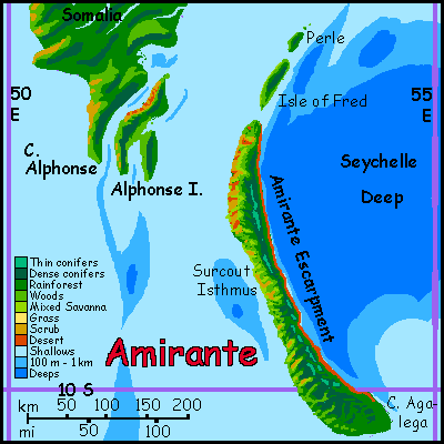
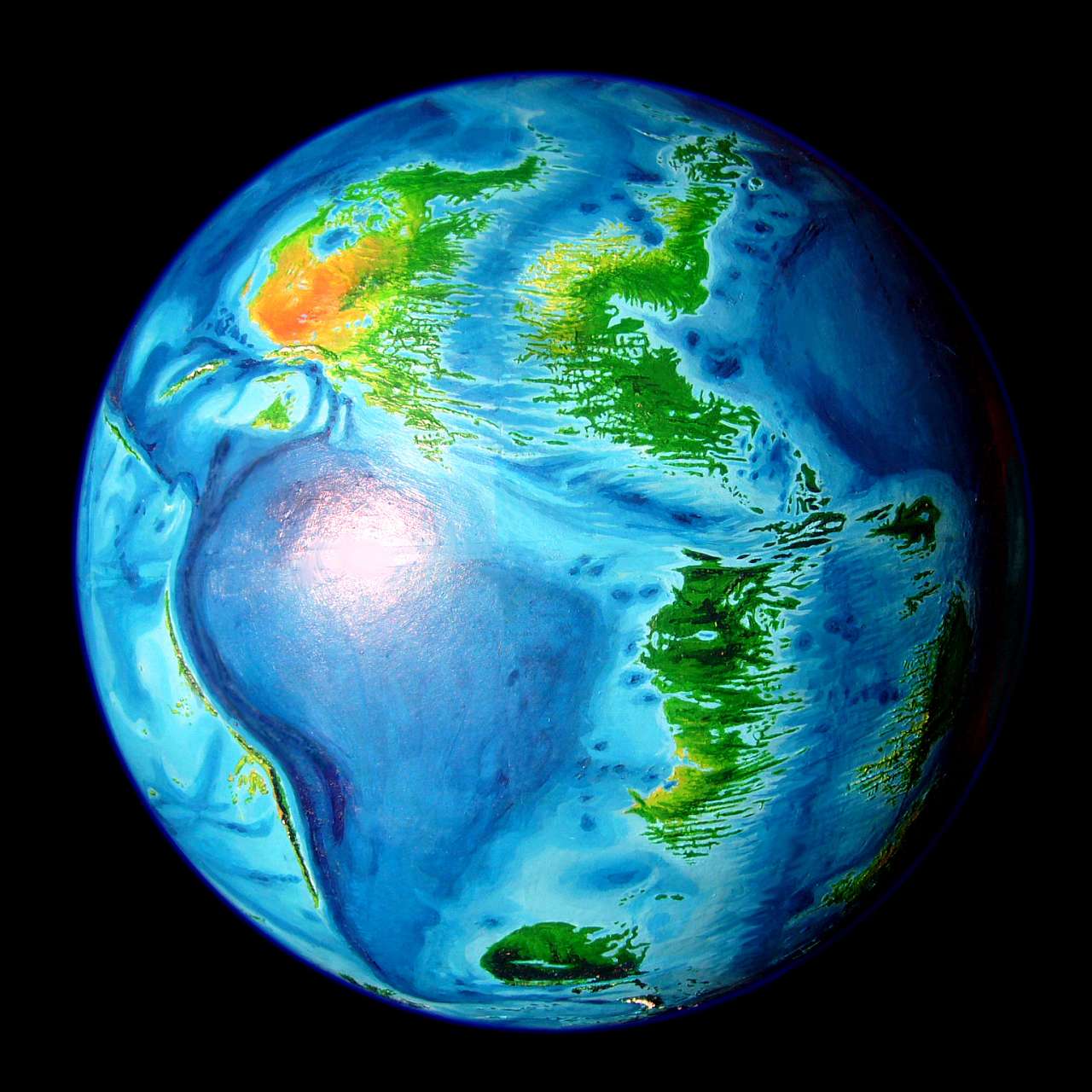
Introduction - Amirante - Outlying Isles - Creatures and Cultures
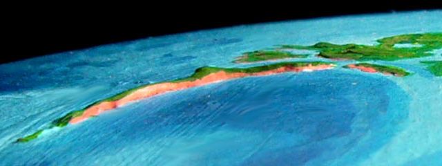
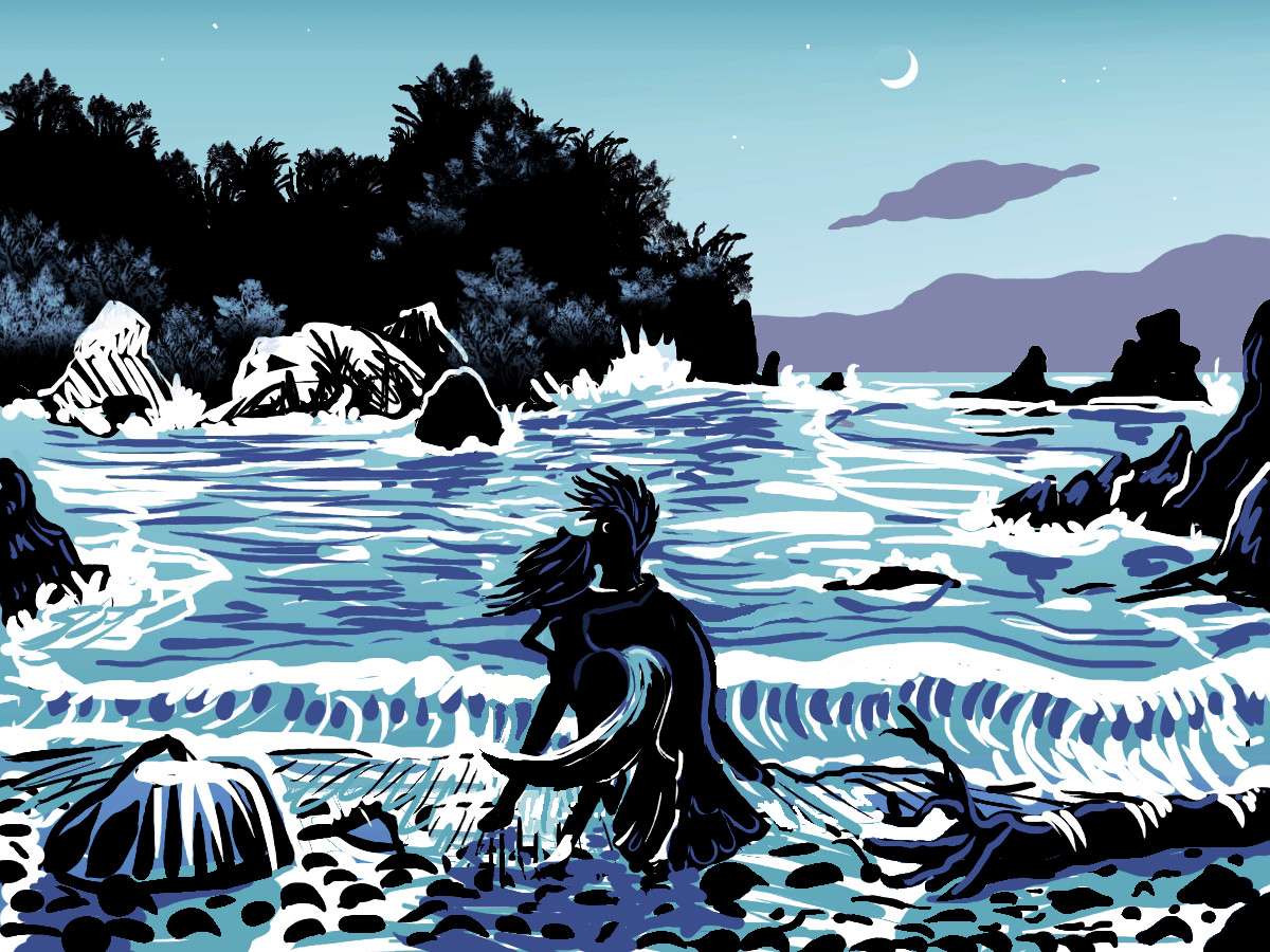
Amirante Island is a must-see for the visitor. This narrow island 500 km long (about 300 mi) has peaks over a mile high and coastal cliffs up to a kilometer high along parts of its eastern shore. Actually they're much taller than that: under the surface, they plummet four more kilometers down, into the Seychelle Trench.
Even the visible parts are quite a sight--red rock palisades striped with waterfalls and dappled green with hanging forests.
The underwater portion--at least the first hundred meters--are equally impressive for divers: vertical reef gardens. Every shape and color you can imagine...
Amirante Island makes its own weather: it's so rugged it snags clouds and forces rain from them, supporting cool misty cloudforest high up and muggy rainforest on the east coast. The west varies but is generally drier; from groves and meadows in the south to open savanna and even red rock canyons in parts of the northwest, in the rainshadow of the island's spine. They look like Waimea Canyon on Kauai.
Indeed, except for its shape, Amirante is quite like an oversized Kauai, though it's climatically flipped north-south of course, since we're below the equator.
Introduction - Amirante - Outlying Islands - Creatures and Cultures
OWEN and ALULA
North of Somalia, two long, narrow, rugged islands rise from deep water--Owen and Alula. These two isles are the inverse of two deep fracture zones where parts of our Indian Rift is spreading at different speeds and make sharp turns as it leaves the relatively spacious Arabian Sea to enter the Gulf of Aden, and soon the Red Sea.
In our world, the Socotra chain rises quite close to Alula. These Terran isles, with (very) dry land upwind in three directions, are arid, though Socotra does have some drought-adapted trees--quite alien-looking! In contrast, on Abyssia, Alula and Owen, in contrast, have deep, warm water around them in three directions and a rainforest in the fourth. As a result, they're more Indonesian or Polynesian than Arabian. Rainforested lowlands rise to backbones so rugged and perpetually cloudwreathed they're largely unexplored--even though they're not high, and just a few miles from the port towns below. Since Alula's the last land for thousands of km north and west--or first landfall in weeks, for ships from Atlantis--I expect Port Alula to be good-sized. The only place to restock on fresh water, fruit and vegetables. Thanks to the rain, the Alulans have lots of those to offer. At a price.
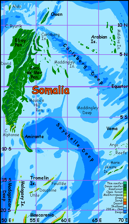
CARLSBERG and the MADDINGLEY ISLANDS
Off Somalia's northeast coast is a broad complex of narrow, winding, ridged islands and reefs--hundreds of them, in a maze 1000 km long and half as wide. The largest, Serendip, is like a gigantic fishhook 320 km long (200 mi).
Both above and below the waterline this labyrinth is exuberant with life. No surprise why; they average 3 m of rain a year (120"). Even the smallest islets look like green nappy mushrooms, with trees almost to the waterline; coral reefs flourish below.
THE ARABIAN ARCHIPELAGO
Much further offshore, over a thousand km east of Somalia, lies the Arabian Archipelago. Two chains of islets form a V shape: the Maldives and the Arabian Chain. All of these are, like Somalia itself, low islands with verdant forest, ringed in coral reefs--not so different from Earth's Maldive Islands (located just a few hundred kilometers to the east; on Abyssia, of course, the Maldive Ridge becomes a deep trench).
VEMA and the ARGO REEFS
These islands, on the edge of the Somalia map, are just off Chagosia, and will probably end up described on that page. If I ever manage to write that page...
The short version: Vema is much like Amirante--a rugged narrow island several hundred km long, with a very distinct wet and dry side. The southeast shore isn't a gigantic cliff like Kauai's Na Pali Coast; but it is steep and verdant. The northwest, on the other hand, does resemble Waimea Canyon on Kauai. Even drier, in fact. Red canyons below the misty green peaks of Vema's spine. But not one Waimea Canyon--dozens, along a 200 km stretch of coast.
Why so dry? Vema's central ridge is never less than a km high and occasionally reach two (3300-6600'). It lies directly across the tradewinds, snagging all but scraps of every storm. So the southeast blooms--at the expense of the canyon coast.
The Argo Reefs are uncertain--atlases vary. At best, this ridge, so much like a lesser Vema, is a chain of coral atolls a few hundred km long--with no land even ten meters above sea level. At worst, just one or two atolls, or mere tablemounts where coral gardens thrive but never break the surface--smashed back by storms. Hard to be sure.
UPDATE: in 2019, I found a more accurate map of the region and found the next fracture zone south of Argo, the Marie Celeste, looks deeper--not as deep as Vema, but deep enough to create, on Abyssia, an island chain stretching southwest-to-northeast; most likely three isles, each a low ridge a few kilometers wide and a few dozen long, linked by extensive coral reefs. At the latitude of Hawaii, the islands are mantled in tropical forest, dense on the hills, open on the less rainy coasts.
Naturally, given the name's spooky history--the Marie Celeste was a boat whose crew all inexplicably vanished--the archipelago has no native intelligent life; though it's the logical place for Abyssia's equivalent of the Dodo to evolve, that shy, naïve people evolved instead on Vema, well to the north; and they've never spread here. Lovely islands, no people. Unless of course they're invisible, or trapped in a parallel dimension, or whatever explanation you favor for the Marie Celeste incident.
MALAGASY and the TROMELIN ISLES
700-1000 km south of Amirante and Alphonse are the Malagasys, a chain of low desert islands just east of the Madagascar Deep. How many islands? How big? I'm not certain. The long main island and several lesser ones on the map are my best guesses, but they're suspect--every bathymetric map I've consulted has had a different configuration here. Or none.
What I am sure of: these are low islands, nowhere rising more than 200 (660') meters and perhaps little more than another maze of reefs. That has ecological implications. At this latitude, around 20 south, tropical rains will fall only for a few months in high summer; the rest of the year, such islands need mountains to force air up, generate clouds and wring rain from them. These dwarfed Madagascars, no matter what their exact configuration, just won't be high enough to snatch rain; so they'll be sunny and fairly dry, especially the western (lee) slopes, something like the smallest and lowest Hawaiian islands. But I've shown the best case: the main isle has enough of a spine so the east coast is deep green, the west brown and gold. It may be less pronounced. Hard to say.
I'm more certain of the Tromelin Chain--a diagonal line of three larger islands paralleling the Wilshaw Trough. Quite large: Feuillee (roughly fuh-YAY) is a good 250 km long (150 mi). While none of the Tromelins are Amirante, their hills are substantial enough to snare some year-round showers, at least on the windward (southeast) side, and large enough for year-round streams under the trees. Quite pleasant.
Introduction - Amirante - Outlying Isles - Creatures and Cultures
2006
At this early point in the decade-long building of a whole world like Abyssia, I'm just starting to deduce what sort of creatures evolve intelligence on an island world like this, and where. So it seems premature to talk much of Somalia's culture. But one point occurs to me...
To the north and west of Somalia is the huge, deep Eurafrasian Ocean, where (on Earth) the Old World rises. To the south and east is most of Abyssia's land; Somalia's geopolitically on the edge, and may culturally be something of a backward frontier--regardless of who Abyssians turn out to be.
But there may be an exception in the north. A port on Owen or Alula, or at the mouth of Chain Sound, would be a good restocking point for sailing ships with crews brave and skilled enough to cut across the islandless ocean to the north. For them, Alula or Owen would be the jumping-off port on the shortest, safest route between Pacifica and Atlantis.
2011
Of course my assumption of port cities assumed that Abyssian sailors need fresh water and fresh food. But would they? Nearly all animals manufacture their own Vitamin C--they're immune to scurvy. And many don't even need fresh water, getting enough from their food--even from dry seeds or grains.
So depending on their evolutionary heritage, Abyssian crews may sail straight across quite casually, living on fresh raw fish and seaweed the whole way, or cracking hard, rat-proof Brazil nuts in their massive parrot-beaks--who knows?
But if Abyssian travelers do need (or want) to restock, and perhaps do a bit of speculative trading in tropical products (as human sailors did), north Somalia might be on a major shipping route after all. Even beings physically able to make such a long crossing may want to take a sanity break now and then. And Somalia's beaches are a nice place to decompress. By any species' standards, it is, after all, a tropical paradise.
2017
Now, six years later in the process, it seems clear from the width of the gaps around Somalia that the most likely species to reach here from outside will be from the south, from Mascarenia (near our Madagascar). They'll most likely be equi from the far eastern continent of Agassiz. But they could plausibly be foxtaurs from Pacific a, or leptaurs from Atlantis--or any mix of those three.
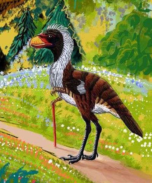
They won't have been the first Abyssian land-animals to make it. Our sailors will have been preceded--by some millions of years, most likely--by storm-blown birds, bright but probably not people--yet. Though on other deeply isolated Abyssian lands, such birds have often risen to intelligence--turned flightless, grown, and used those forehands to experiment with tools.
But not always--and not on Somalia.
Why? Other than wood, material for tools is scarce. Good stone is rarely exposed in the rainforest. And these birds certainly lacked many opportunities to play with fire--both thunderstorms and dry tinder are way more common on the savannas of the larger continents--Atlantis, Pacifica and Agassiz. Or maybe the lush rainforest just offered too few challenges (but rainforest elephants, parrots and apes aren't stupid! Social challenges are quite as daunting as environmental ones.)
Most likely it was that often-overlooked, powerful Darwinian factor--simple chance.
The lack of an intelligent native avian doesn't mean there are none on Somalia--just that they'll come north like the mammals, following the Malagasy Islands, hopping to Amirante, and settling the Somalian mainland in a wave from the south.
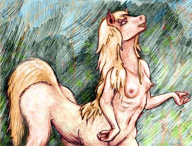
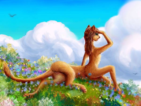
In short: who settles Somalia seems less sure to me than anywhere else. Any of half a dozen species seems perfectly plausible--as do mixes of those species, including blends with no majority at all.
Titani? |
Albatrosians?
|

Peacocks?
|
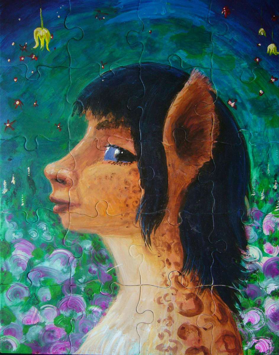
It's a puzzle! |
I mean, it's a real puzzle, not a digital filter laying jigsaw seams on an image. A puzzle fiend I know gave me this blank jigsaw, and I couldn't resist painting a portrait of a Genuine Somalian on it.
Abyssia's homepage - map - peoples - regional tours - names
LISTS AND LINKS: More worlds? Planetocopia! - dreams of other worlds - ecology - climate change - evolution - natural disasters - terraforming - sculptures and 3D art -
World Dream Bank homepage - Art gallery - New stuff - Introductory sampler, best dreams, best art - On dreamwork - Books
Indexes: Subject - Author - Date - Names - Places - Art media/styles
Titles: A - B - C - D - E - F - G - H - IJ - KL - M - NO - PQ - R - Sa-Sk - Sl-Sz - T - UV - WXYZ
Email: wdreamb@yahoo.com - Catalog of art, books, CDs - Behind the Curtain: FAQs, bio, site map - Kindred sites