Abyssia: Whartonia
by Chris Wayan, 2007
for Wharton
Abyssia home - down to map - building Abyssia - geology & geography - critters & cultures - the clash of names - more worlds? Planetocopia!
Abyssia: Whartonia
by Chris Wayan, 2007
for Wharton
Abyssia home - down to map - building Abyssia - geology & geography - critters & cultures - the clash of names - more worlds? Planetocopia!
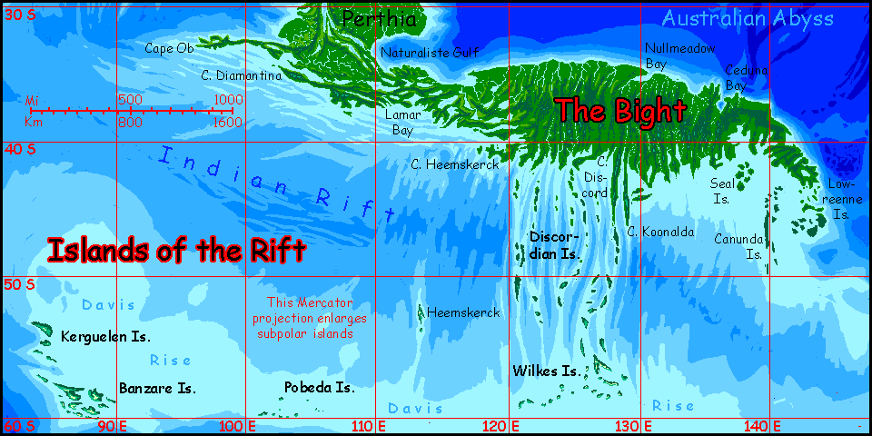
Introduction - Coasts & Names - Holes - The Moat - Peoples - The North - Perthia - The Bight - Discordian Is.
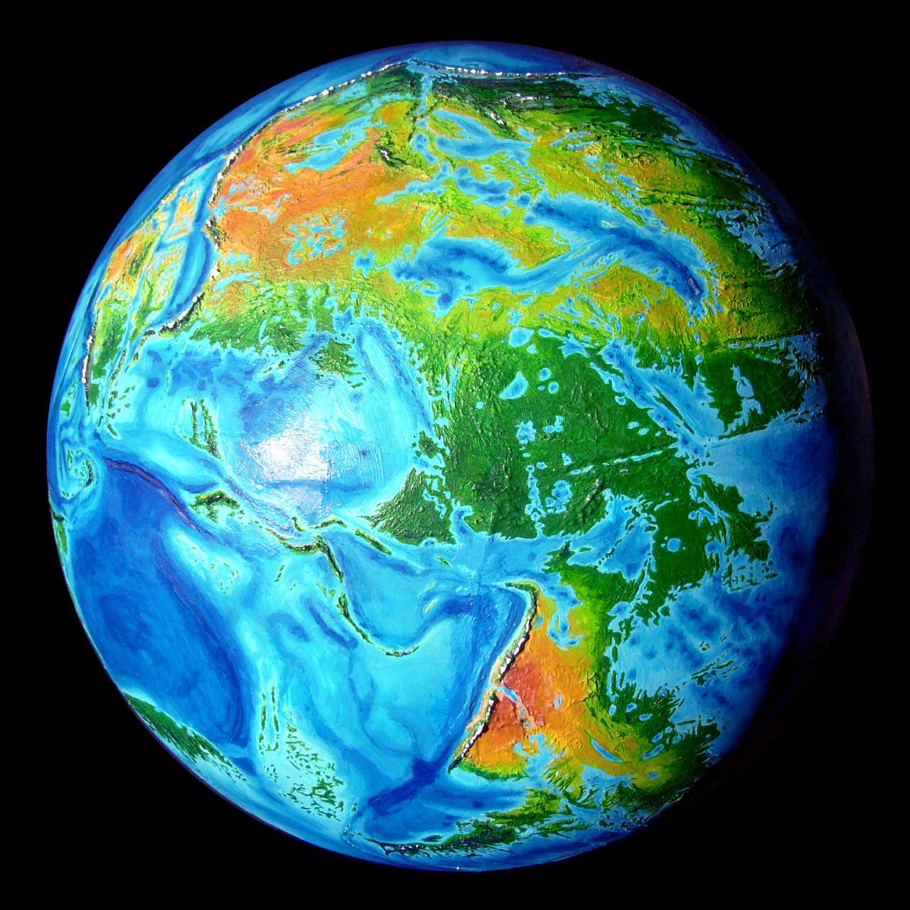
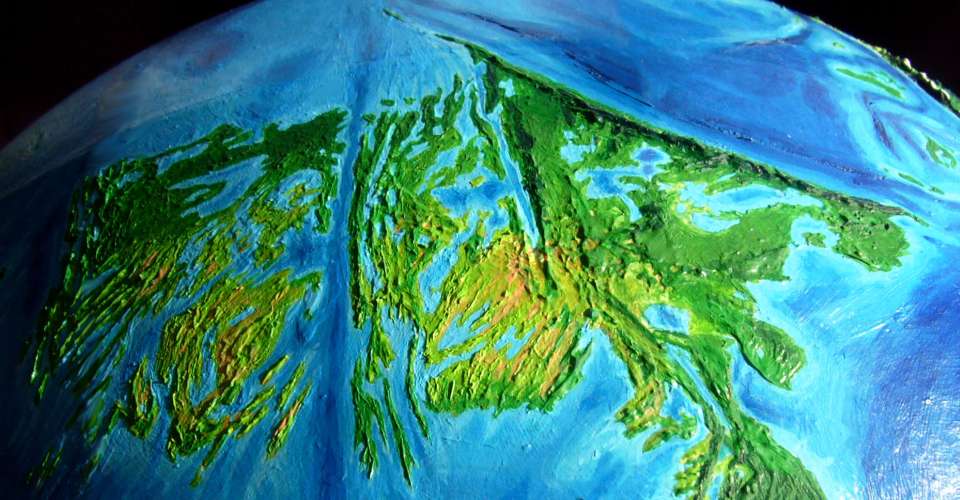
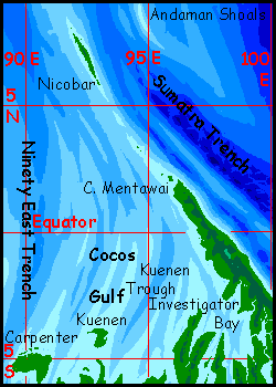
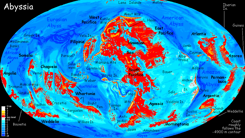
The Indian ocean floor is complex, but very little of that complexity breaks the surface. Madagascar, the great arc of reefs from the Seychelles to Réunion, the long line of the Laccadive and Maldive Islands south from India, the chilly islands of the Kerguelen plateau off Antarctica, a few random islets... and you're done. The sea hides the great Y-shaped undersea rift zone, the intricate fracture systems around the rifts, and the almost Andean range called the Ninety East Ridge.
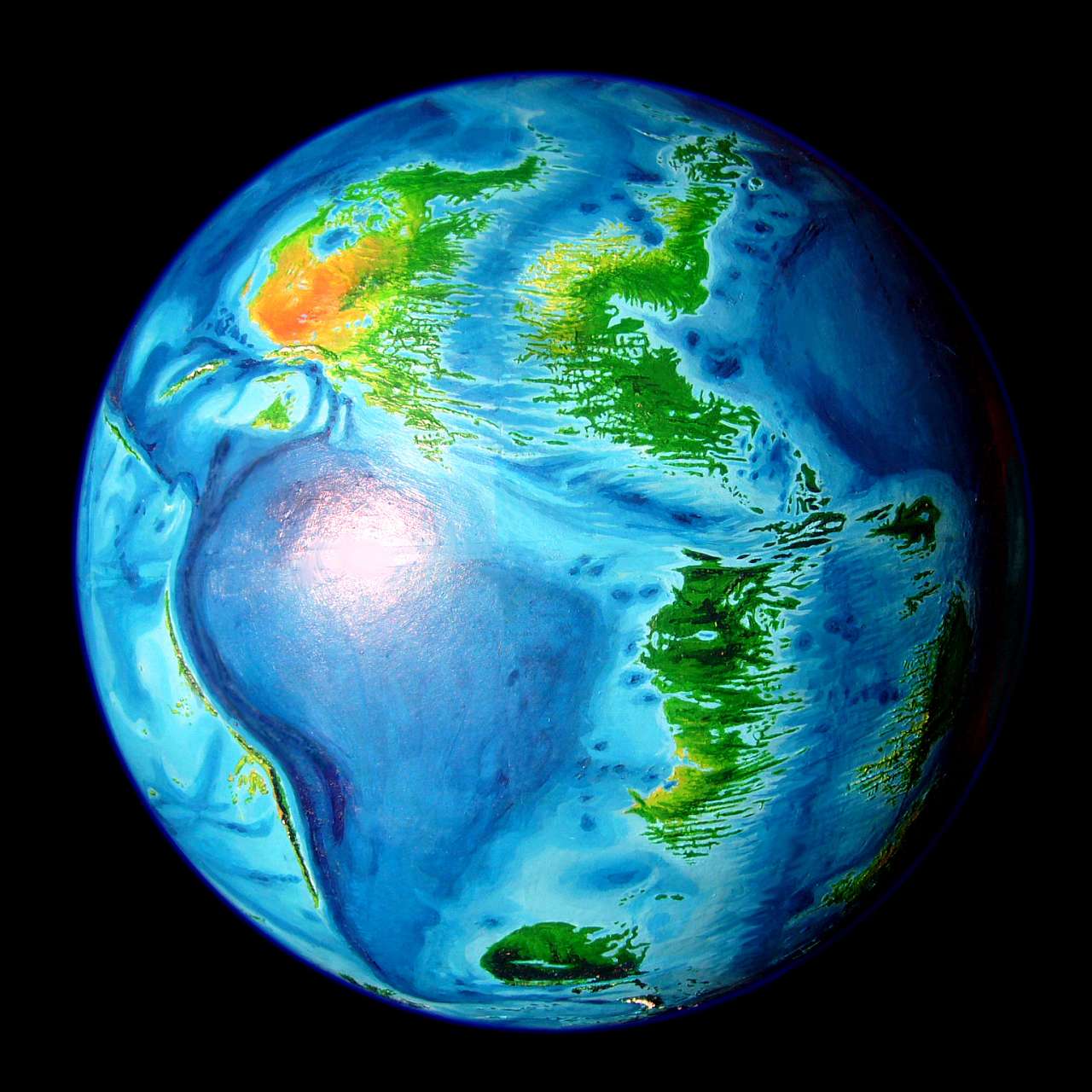
On Abyssia, the Indian Ocean becomes a rise, of course, but not a great continent called India. That forking rift divides it in three main platforms supporting nine major landmasses. Six are big islands comparable to Madagascar--Agulhas, Bouvetia and Natalia in the west, Somalia in the north, and central Mascarenia and Crozetia. Three surely qualify as continents: Weddellia in the south, north-central Chagosia, and Whartonia in the east, by far the largest--almost Australian, and the third largest continent in the world (remember, Abyssia has less than half the land area of Earth).
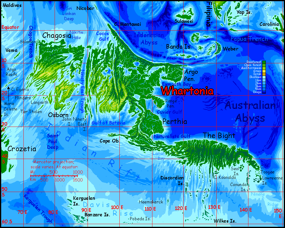
Whartonia is a three-lobed continent:
Introduction - Coasts and Names - Holes - The Moat - Peoples - The North - Perthia - The Bight - Discordian Is.
We tend to think of the abyss as a featureless muddy plain. The truth is that every new sonar sweep reveals more complexity; it's quite jagged down there. The fjordlike bays serrating the shores of Whartonia are the result of huge fracture zones. Lacy, crazy coasts like these repeat all over the planet--you can see why I've been slow to finish the relief and painting of this globe! Earth does have a few of the features I've here called "mazes" (see a close-up map of southern Chile's fjords!) but ours are mostly ice-gouged. Abyssia's aren't.
The closest analogy would probably be basin-and-range country, where land gets squeezed upward and dropped in blocks and splinters, rather than valleys getting carved by running water. For example, Mount Whitney drops 3300 meters to the Owens Valley, which rises 2400 more to the Panamint Range, which drops 3500 more into Death Valley. Flood it 1200 meters deep (4000') and it'd look a bit Abyssian.
Only on Abyssia, hundreds of great splinters and tilted blocks are sliding, jostling, rising, dropping. Of course they're all here on Earth too, but miles down, where their struggle's unseen. On Abyssia it happens near sea level where it really shows--even if much of the action is still underwater.
Low doesn't always mean gentle. This is young, raw crust full of scarps, ridges and canyons--it's just that many are still underwater. But not all. Western Whartonia, especially, is a jagged fracture zone--an endless procession of cliffy heads, deep sounds, islands and shoals, as is Chagosia across deep Ninety East Trough. Much of the Bight (southeast Whartonia) is equally rugged--the product of an undersea rift zone called, on Earth, the Australian-Antarctic Discordance.
Still, it's better than the south Atlantic or barely-mapped southeast Pacific. There, Abyssian names may be based on a distant Earth feature. For on Earth, a seamount or islet often gives its name to a nearby fracture zone--and these zones can stretch 2-3000 kilometers! So on Abyssia, the name may crop up on a peninsula or sound a whole continent away. And many atlases ignore the lesser fracture zones, so names here can look like thousand-mile longitude errors.
Fortunately, such displacement is less extreme around the Indian Rise, because fracture zones here are shorter and curve more than in the Atlantic--an effect of the curved and forked rift itself, I think. Still, some of Whartonia's names are borrowed from features hundred of kilometers away. Just not thousands!
Though some of the names may seem strange, they're based on real ones on Earth. Judgment calls, yes, a few of them desperate--but the names are not arbitrary, any more than the landforms are.
A few, I did make up. Long Lake, paralleling the west coast of Whartonia (one ridge inland), is simply the longest freshwater body I've found on Abyssia--and I haven't found a named feature within hundreds of kilometers. Then there's Lake Trefoil in the southwest, shaped like a three-lobed leaf. The names of the Wilkes Islands are mostly descriptive--except the southernmost, the Porpoises. In the Discordian Archipelago I've named the major islands for literary and legendary troublemakers, tricksters and pests. Yet in the Banzares and Kerguelens, they're named for nearby features. That's always my preference--where names are available.
My point? Intrepid explorers peer into the abyss and think "Well, that sorta looks like a bunny..."
Introduction - Coasts & Names - Holes - The Moat - Peoples - The North - Perthia - The Bight - Discordian Is.
Our sea-floor's peppered with volcanoes, far more than anyone expected. These are a scientific and esthetic challenge on Abyssia--what's the tectonic explanation for all those conical pits? Abyssian geology would madden any Terran--but it's worth noting the reverse is true, too. Why not an active mantle with a lot of puckers where crust is crunched in a "downdraft", a world with rifts that pull inward instead of spreading? This isn't theoretical: puckers like this really can be found on Venus ("inward" coronae), and the hottest convection system of all has lots of them: we call them sunspots. No volcanic cones on the sun!
Abyssia doesn't spew, it just sucks.
These pits are most noticeable--and problematic--in northern Whartonia's Great Lakes. Some of these--Lake Christmas in particular--are many kilometers deep. While they cover slightly less area than North America's Great Lakes, they hold many times the volume of water; more than half of all the fresh water on Earth, in fact!

Introduction - Coasts & Names - Holes - The Moat - Peoples - The North - Perthia - The Bight - Discordian Is.
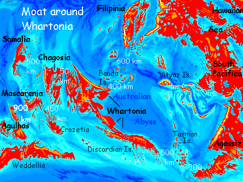
The Indian Ocean rift is continuous with the Atlantis Rift; on Abyssia, unlike Earth, where the whole spectacular complex is drowned kilometers deep, here it become the Atlantis Rise, a band of large islands and small continents snaking 20,000 km or more around the African and Australian Oceans. Whartonia is the east end of this long strip. But around Whartonia, there are gaps.
To the east, the peoples of the Pacific hemisphere, hopping from Pacifica and Agassiz to the surrounding archipelagoes and mini-continents won't paddle so easily to Whartonia--nor vice versa. From northeast Whartonia to the the outermost Banda Islands it's over 400 km (250+ mi), and nearly 600 (350+ mi) from the Bandas to anywhere else over the deep (and typhoon-happy) Halmahera Deep. From southeast Whartonia, it's over 500 (300+ mi) to the westernmost Tasman Islands, and 300 km or so to mainland Agassiz. Shorter passages, colder seas...
To the west, it's an easy hop--in sight from a hilltop on a clear day--to Chagosia, a large island or minicontinent. But beyond it, again there are wide gaps--nearly 450 km (280 mi) southwest to the Melville Islands off Crozetia and Mascarenia, or 500 due west to Vema and the Arabian Isles leading to Somalia.
But Somalia and Crozetia/Mascarenia are navigational dead ends. Beyond them, the next land on the Atlantis Rise is the Agulhas Group--nearly 1000 km of deep sea. 600 miles with not a rock.
Effectively, there's a deep moat around Whartonia, Chagos, Mascarenia and Somalia. Only confident deepwater mariners will reach it--and that means late contact, compared to other parts of Abyssia. The eastern passages are shorter, so I expect the first foreigners will enter from the Banda or Tasman Isles, and only in the last few millennia.
Introduction - Coasts & Names - Holes - The Moat - The Whartonians - The North - Perthia - The Bight - Discordian Is.
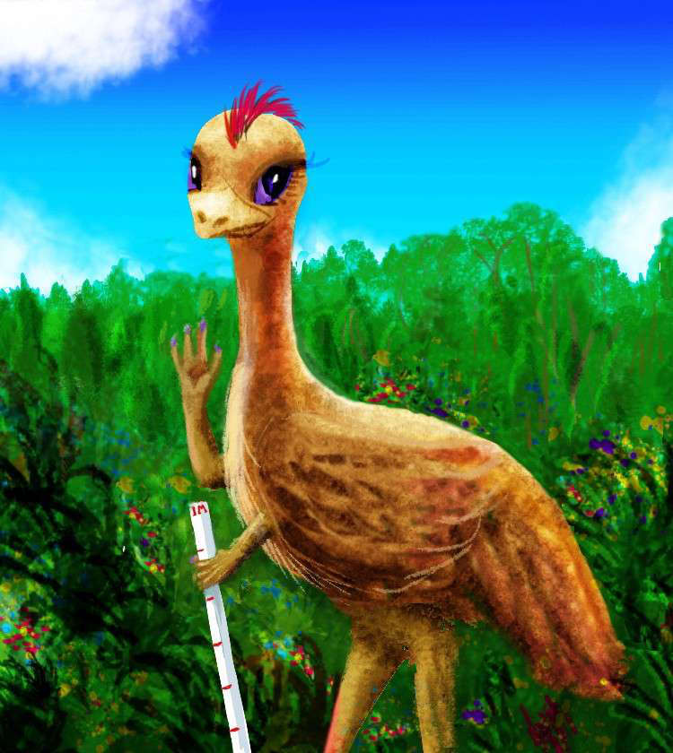
Whartonian emu; 180 cm tall |
Because Whartonia's isolated, I suspect at least some natives will have evolved right here. It's a big diverse land after all. The rest will be rather recent settlers of other species, mostly from the east where the sea-passages are easier--if not easy.
Since Abyssian vertebrates have six limbs, large flightless birds with forehands and centauroid mammals are the two groups most likely to develop civilization. I'll deal with each in turn.
NATIVE BIRDS
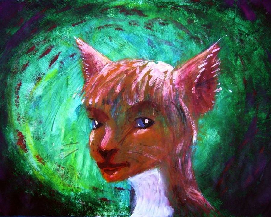
Abyssian landmasses are nearly all true continents like Australia, not lobes with pretensions like Europe, or linked by land bridges like Asia and Africa or the Americas. As a result, each landmass has its own endemic flightless giant, descended from quite different winged ancestors. They've converged somewhat in appearance--their stature, their forehands and their heads grew as brains and hands became a premium--but they're not races but species, and not cross-fertile. That doesn't mean mixed-species mating and marriage don't happen, but they're complicated, with crosslinked fertility-mates and living-together-spouses that create extended, rather confusing clans.
I've tried to make the dominant bird of each Abyssian landmass (if any; they don't evolve on every single rock!) similar to the nearest ones (usually extinct) in our world. For Whartonia they'd be the emu of Australia and the extinct Aepyornis or Elephant Bird of the Indian Ocean islands--the source of the legendary Roc's eggs. The emu is modest-sized, the Elephant Bird gigantic. I'm compromising--the Whartonian Emu is much larger than our emu, a bit larger than an ostrich, the largest living Terran bird--but no Roc.
I find it amusing that they're called (and resemble) emus, since the southeastern third of Whartonia, called the Bight, looks like an emu. Not a contrived geographic joke of mine; it really is how the seafloor countour 4900 meters down maps out as a coastline.
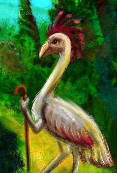
Kasowar; 140 cm tall |
So... land of the emu.
Whartonian emus aren't just scaled-up ostriches. Yes they're leggy, yes they can run, but these days they don't need to. Those big hands carry tools--or weapons if need be. More importantly, those big brains hold plans.
Still, the emus, like ostriches, evolved in savanna and Mediterranean country--groves and meadows--where running is easy. They tolerate open woods, but get anxious in the dense rainforests of far northern Whartonia. Damp, too. Their feathers evolved for display not insulation; the savanna is hot! Their feathers aren't waterproof. They don't mind a few showers, but the relentless rains in the north--up to 3 meters (120"!) in the equatorial zone east of the Investigator Hills--leave them bedraggled, miserable, and prone to fungal diseases.
But emus are common in the drier northwest, in central Wartonia (called Perthia) and in the Bight.
NON-NATIVE BIRDS
One of the species that's settled Whartonia from the east is also avian: the semi-arboreal kasowar. Kasowar will settle in modest numbers in the wooded country of northern Whartonia, Perthia and the Bight; but their homeland will be on Whartonia's north coast and around the Great Lakes. The kasowars, being able to climb trees (not as easily as apes, but they're more comfortable than humans up there, and they're light enough so falls are rarely fatal), will be more effective than the native emus at exploiting rainforest resources; kasowars don't live in the jungle canopy but they can cultivate and harvest its fruits (and nuts, greens, treetop animals, honey, flowers, perfumes, lumber, herbs and medicines).
I suspect a smaller non-native avian to be quite noticeable in port towns: the peacocks of Somalia, the minicontinent a couple of thousand km to the west. Noticeable because their tails are showy; not numerous.
I suspect you won't see another non-native that evolved closer to Whartonia, on the Isle of Vema, just west of Chagosia: the dodos, though intelligent, are timid and rarely leave their native island.
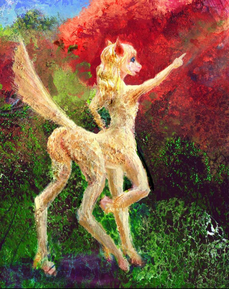
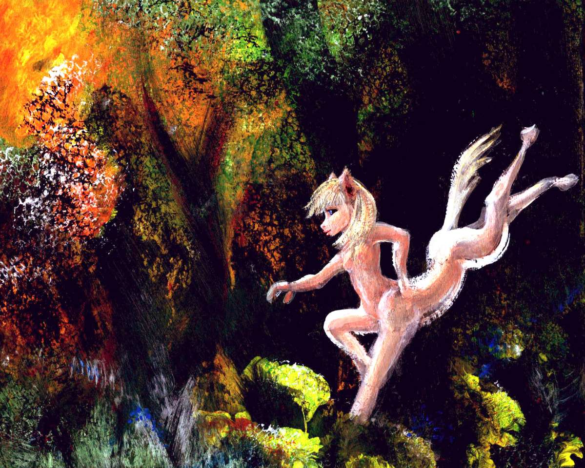
Equa pointing; 165 cm. tall |
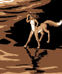
Foxtaur; 120 cm. tall |
NON-NATIVE MAMMALS
Nearby Pacifica has much larger savannas than Whartonia, and they nourished the evolution of at least two species of intelligent centauroid mammals:
THE EQUI (left). A deer-sized, horse-maned and -tailed centauroid with paws not hooves; omnivores, though tilting herbivorous. Evolved in the prairies of central Agassiz.
FOXTAURS (right). A smaller, doglike omnivorous heat-tolerant centauroid liking to burrow. Evolved in savanna and desert around the Hawaiian Sea in central Pacifica.
Both these centauroids will be common sights in Whartonian ports (they swim better than either emus or kasowars, and are more confident sailors).
I suspect foxtaurs will get here first over the Halmahera Gap from Filipinia through the Banda Isles, but they won't find land suited to them for thousands of km, and hence won't be common beyond ports.
The equi, though they'll have arrived centuries later over the Tasman Gap, will be more numerous and settle well beyond port towns--the Bight and and Perthia are much like home, and the grasslands of western Whartonia will be eq paradise.
Leptaur; 150 cm. tall |
Also present in port cities--in smaller numbers--will be a much more recent immigrant, the leptaur, from the Atlantis Rise to the west. Also confident sailors and traders. Although feline in appearance, they too are omnivores not obligate carnivores. All hunt and no gather is a poor foundation for intelligence--hunting is indeed mentally challenging, but grueling and dangerous too. Fruit, on the other paw, can't fight back. Wolves, with very big brains (rivaling chimps') die in their teens; a chimp or an elephant at fifty or sixty is still going strong--and learning.
So equi, foxtaurs and leptaurs evolved from creatures who might have been predators and prey; but trade favored the flexible, and today all are omnivores, if diverse ones. You can eat in any of the cafes. Well, unless the cook's incompetent! Even on monotonous Earth, that peril hath slain many a traveler. So it is on Abyssia. But in the big ports, competition's too stiff--the cuisine may look odd, but it'll be more than edible--downright good.
Introduction - Coasts & Names - Holes - The Moat - Peoples - Northern Whartonia - Perthia - The Bight - Discordian Is.
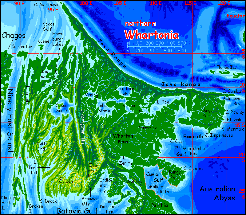
Let's start in the northwest. Over 500 km off the tip of Cape Mentawai rises Nicobar, a narrow, hilly island at least 160 km long and maybe 240 (100-150 mi). It's a last gasp of the Java Range before it sinks into the Eurafrasian Abyss. Nicobar is verdant rainforest. Expect the primitive.
Even if it's discovered by mariners (or fliers, if Abyssians are winged, as is just possible) following the line of islets and shallows out from Mentawai, beyond Nicobar is 7500 km (nearly 5000 mi) of deep sea, unbroken all the way to the Greek Isles--or polar Lena. Definitely not a major port of call!
No, wait. If Abyssian mariners skirt the great sea, they might just find Nicobar a useful way station. From Filipinia and the west coast of Pacifica to Nicobar to the Maldives (well northwest of ours, which are of course a large trench), to Owen and Alula north of Somalia, and then the long haul to the Greek Islands--then due west to Azorea, gateway to Atlantis. Yes, I'm convinced. A port near the northern tip of Nicobar, where ships can stock fresh water and fruit, is possible, even likely. So Nicobarians, whatever species they are, may be rainforest critters, but quite cosmopolitan.

Andaman tree-squid; 3m span |
On the other hand, everyone will avoid the Andaman Shoals to the northeast. This rise supports coral reefs just shallow enough to rip out a hull; they lack islands high enough to have more than a narrow strip of rainfed trees. No freshwater creeks; not even a well.
Or is my land bias showing again? There still could be Andamanese; a reef-dwelling intelligent species wouldn't need fresh water and for good swimmers the shoals would be a rich and pleasant place. Abyssia, with many times the reef area of Earth, is many times more likely to develop intelligence there, among its equivalents of marine mammals and octopi or nautiloids. Consider all the creatures, even on poor impoverished Earth, that creep out of the sea to play on the beaches, give birth or lay eggs, climb trees and pick fruit... Unlikely though it sounds to us, given enough time and chances, some Abyssian will crawl out onto land often enough to play with fire! Enough chimps and typewriters, and you get Hamlet. Well, in this case The Tempest.
But are the Andamanese naïve Mirandas, trickster Ariels, or angry Calibans? Depends how the mariners have treated them. Terran history's not encouraging...
And yet, Abyssians have--have to have--a long history of getting along and trading with weird-looking (and smelling) neighbors. Over a dozen species rubbing elbows. And other things. It's possible the Andamanese will have settled Nicobar themselves, and spread all along the rainy coast of northern Whartonia, and maybe even through the Great Lakes region on the far side; it's all rainforest and the natives I proposed above won't be flocking to settle the wettest bits. These amphibious folk might do quite well there.
The north coast of Whartonia isn't just wet--it's the ruggedest stretch on the continent. The Java Mountains form a great wall, though these peaks aren't high by Terran standards--about 2400 meters (nearly 8000'). Only a few thrust above the equatorial cloud-sea, so most of these slopes are wrapped in perpetual fog and drizzle. Punctuated by downpour. Dripping cloud-forest, except the highest summits--grassy, sunny viewpoints that'd be spectacular if anything below could be seen but that sea of cloud.
The coast below is a bit drier--monsoon forest with rain most of the year but sunny stretches from May to October when the summer sun pulls winds north, and this slope is suddenly the lee side of the mountains.
All that rain feeds the forest. Few clearings here in the north! Just a few riverbanks. Otherwise, trees shore to shore--trees 60-75 meters high.
The east coast of Whartonia is equally verdant rainforest; these low shores let storms roll deep inland, and they don't dry out fast; as with Amazonia, these forests transpire nearly as much water as they absorb, and the Great Lakes top off the rainclouds. A single forest covers Argo and Gascoyne Plains; only the woods of western Wharton Plain, in the heart of the continent, open out a bit.

In the midwest, the Investigator Mountains form a sudden wall about 1.5 km high (5000'); the western lands are much drier. As with Australia's Great Barrier Range, it doesn't always take sky-piercing peaks to cast a rainshadow! At 25° north or south, hills like these are plenty. But Whartonia's fortunate. The Investigators' placement means only the western third of the continent is dry; and even so, the many lakes and sounds keep the west relatively maritime in climate; even the driest plains north of Batavia Bay are golden veldt, not red desert.
The far west is a maze of semiarid capes with dry grassy slopes and wooded heights. Deep blue saltwater sounds wind far inland--Investigator Sound is 1350 km (800 mi) long, and branching Cocos Sound nearly bisects the continent. The climate varies--the north shore is tropical and wet, but the rains grow steadily more seasonal to the south; past Cocos Sound, they get unreliable, especially inland.
This contrast between coastal and inland (Outback?) is nearly as pronounced as the north-south rain-gradient from Congolese to Sahelian. For example:
Broken Island and 90 East Island off the southwest are quite green. This shouldn't surprise us. But...
The coastal hills above Ninety East Sound are just as surrounded by open water--not just the sound, but thousand-mile Long Lake. It's effectively an island too. These shores get light rains and mists year-round as well as the monsoon. On Earth, some islands at this latitude are green, but not one continental west coast. But Whartonia, small, low, broken and lake-dappled, is as much an archipelago as a continent. There simply isn't enough dry land upwind to create a desert coast. Deserts breed deserts--but to start this spiral requires continuous landmasses--continents. Whartonia, though large enough to be called a continent, is distinctly discontinuous--like most Abyssian lands.
Sheer size counts for something, though. The country around Lake Trefoil, still coastal but somewhat more continental, isn't desert either, but it is drier--open savanna, with scattered groves and riverine strips of trees.
Further inland, Raitt Plain, between Investigator Sound and Raitt Sound, is mostly dry grass and scrub. Still not desert, but big stretches are quite treeless. The sounds are big enough (they nearly bisect the continent, after all!) to generate local fogs, nourishing patchy forests on the shadier sides of surrounding ridges. Dark forest one face, savanna the other. Microclimates.
In the southwest, huge nomadic herds of centauroid grazers on the even bigger grasslands of Gulden Veldt. No, that's not a mere description disguised as Dutch; the nearest named feature on Earth is Gulden Draak Seamount, named for an East India Co. vessel wrecked in the region centuries ago. But it's a nice coincidence: a Golden Field it is! On the other hand, shallow Lake Gulden is muddy green, not gold.
Are these savanna herds intelligent? Are these equi, or their primitive cousins, something like their ancestors were on the plains of Agassiz a million years ago? Like apes next to humans? Will the equi herd them, protect them... or shun them, a little embarrassed at their lowbrow kin? It happens among humans.
Despite their proximity to Gulden Veldt, the shores of Indiaman Bay are quite a bit rainier; storms come off Cuvier Gulf, Lake Zenith, Lake Wallaby, and the Lost Dutchman Bay. Groves and meadows and scrub, not the dry savanna to the west.
With one exception. Zeewyck Valley is rainshadowed by the coastal Brouwer Hills. It's Whartonia's nearest thing to a desert, though the Zeewyck River (fed by greener heights), keeps flowing even in the dry season. But the hillslopes and floodplain is dusty shortgrass, green only a few weeks a year--usually. When it doesn't flood--or the rains fail entirely. If Zeewyck Valley sustains a civilization, it will be one of farmers irrigating those bottomlands--and praying to the river and sky. Pessimistic farmers. With cranky gods. You know folks like that. Not a problem--until they start exporting their jealous gods.

Introduction - Coasts & Names - Holes - The Moat - Peoples - The North - Perthia - The Bight - Discordian Is.
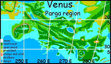
Perthia, to the south, is a strange zone of twin winding ridges with a chain of long lakes between them. It looks exactly like a lesser rift zone of spreading crust; compare it to Africa's Great Lakes region! An even closer analogy can be seen on Venus: Parga Chasma.
Here, let me terraform Venus--hang on, this will take a few seconds--um, clean up the atmosphere--add water to a comparable sea level--there! Even the same latitude and climate...
What's really odd is that Perthia's inverted, yet it truly looks like East Africa's rift or a Venusian chasma (and tectonically, those are just different breeds of the same beastie: spreading zones). Based on the deep scientific principle of Overbroad Generalization (hey, an 'innie' and an 'outie' are still both navels) I think the exact same process is going on here on our Earth too; I suspect spreading from a minor spur of the Indian Rift. The meandering chasma, without fracture zones at right angles (as in the Atlantic or other parts of the Indian rift zone) suggests thinner crust and more fluid rock/magma.
It's true in East Africa, it's true on Venus (hotter crust!) and I bet it's true here.
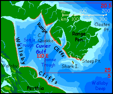
One more Venusian oddity: Cuvier Gulf, on Perthia's northeast coast, has endless coastal cliffs that remind me of the Vaidelute Cliffs southeast of Alpha on Venus. It just has the same scabby look. Maybe a hard stratum of basalt over soft sedimentary rock, undercut by wave action? Or just a lavaflow solidifying first at the rim, like thin pancake batter or frying eggs...
Hmm. I've been writing all morning, obsessed, not eating. Hungry planetologist gets haunted by wrong kind of plates! Cliffy blue-plate special, yum... Better halt for (very) late breakfast.
OK, I'm back and refueled. No longer food-obsessed.
So... Cuvier Gulf... Cliffs, tourists, but not much trade--few good harbors! For hundreds of kilometers most rivers run inland away from the Gulf, for the plate around it slopes slightly away, as if it's a great, low caldera.
Hmm. No, I don't think so. Unless it's very big and very old indeed.
Whatever it is, it exists on Earth--a cliff inverted is still a cliff. A minor mystery conveniently buried under miles of sea. But Abyssia drags all the skeletons out of Davy Jones's locker.
Let's head on south. Perthia's southwest has two bold, rugged peninsulas, Cape Ob and Cape Diamantina. Geologically they're the west end of the Diamantina Fracture Zone that creates huge Bight Peninsula, Whartonia's third lobe. Ob runs west some 500 km (300 mi) into the deep Gulf of Batavia. Jagged coastal mountains out near Ob's tip reach about 2 km (6600'), quite like Australia's Mt Kosciusko, and at a similar latitude. This means real snow! Half the year you could ski up there. The first temperate zone we've seen on Whartonia--small but real.
I did say small. Oranges grow on the sunny north coast ten miles away.
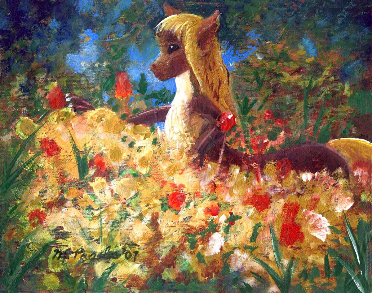
This area--sunny, mild, scenic, not too rainy, is much loved by equi. They grow subtropical fruit and, well, anything exportable. Though the flowers in the paint-sketch aren't for export, they wouldn't last. Shipping is literally by ship, remember. Air couriers are strictly for urgent news and messages--far too pricy for routine business.
The equi just like flowers.
To the southeast, across narrow, deep Dordrecht Sound, is Cape Diamantina, whose long ridges rise even higher--to 2.2 km (7200'), rivaling the Java Mountains up north as the highest on Whartonia. Snowpacks here are quite extensive most winters.
North and east of Ob and Diamantina's coastal mountains is more low country: an extension of the winding lake valleys and flanking ridges of northwest Perthia, curving around Naturaliste Gulf. But here the chasma, if such it is, frays from a single Tanganyika-style rift into many braided valleys cupping the Naturaliste and Leeuwin Lakes.
Here Whartonia narrows to an isthmus barely 100 km wide; and by sailing up Lake Leeuwin, one could get within 16 km (10 mi) of Zeehaen Sound to the south. What's more, the hills between are low and broken. If the local Abyssians ever decide to dig a Whartonia Canal, this is certainly the spot.
Beyond Leeuwin Isthmus the lake country continues for another 500 km, widening steadily, until it's clear we're on a new lobe of Whartonia...
Introduction - Coasts & Names - Holes - The Moat - Peoples - The North - Perthia - The Bight Peninsula - Discordian Is.
I know, the name is annoyingly inappropriate for a long convex peninsula--but it's the inversion of the Great Australian Bight. The Bulge Peninsula? Equally ugh. Let's leave it Bight.

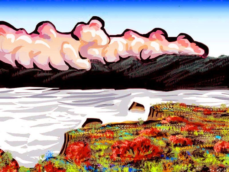
An equa in the glades of the central Bight; dry-brush painting by Wayan |
The Bight is big: 3600 km (2250 mi) from the Leeuwin Isthmus to Point Toogee. Plus, it's solid--one of Abyssia's few lands with an inland inland! Quite continental.
THE NORTH COAST looks quite Terran too--not fractal and chaotic like so many Abyssian coasts. That's because it's a sort of inverted version of Australia's Nullarbor Plain, which it faces. Despite the precedent, I can't call it Nullarbor too: trees are everywhere! The Bight is further south than Australia's Nullarbor, more like the latitude of Melbourne--an east-west strip of ideal climate! And with ocean both to the north and south, rains here will be more reliable than southern Australia.
The best compromise is to call it Nullmead--not a clearing or meadow for hundreds of miles! The Nullmead Plain.
The Bight has a mild maritime climate, but subtropical, not tropical; the Nullmead shore rarely gets frost, but it can happen, briefly; and brief winter snows aren't unheard of.
INLAND, the rugged, mile-high central mountains and deep valleys are rather like Tasmania--similar land and latitude--but again, the climate's milder. No Antarctica, remember. Less wind, a little more rain. Heath like Tasmania, but more woods. The valleys and lakes get light, brief snows most years, though it can linger on the ridges and tors for months.
IN THE EAST, from Point Toogee it's a good 600 km (nearly 400 mi) to the Tasman Archipelago. It's based on a third leaf- or feather-shaped rise like the Bight and the Davis Rise creating the Discordian islands just to the south. The Tasman rise isn't quite like either one--it's nearer the surface than Davis but slightly deeper than the Bight. So the platform supports a labyrinth of coral reefs and lagoons, bigger than our Great Barrier Reef, and its ridgetops become large islands--spindly, but many hundreds of kilometers long.
And these islands lead to quite a mainland: you're never without a hint of land on the horizon, all the way to the continent of Agassiz, second largest in the world.
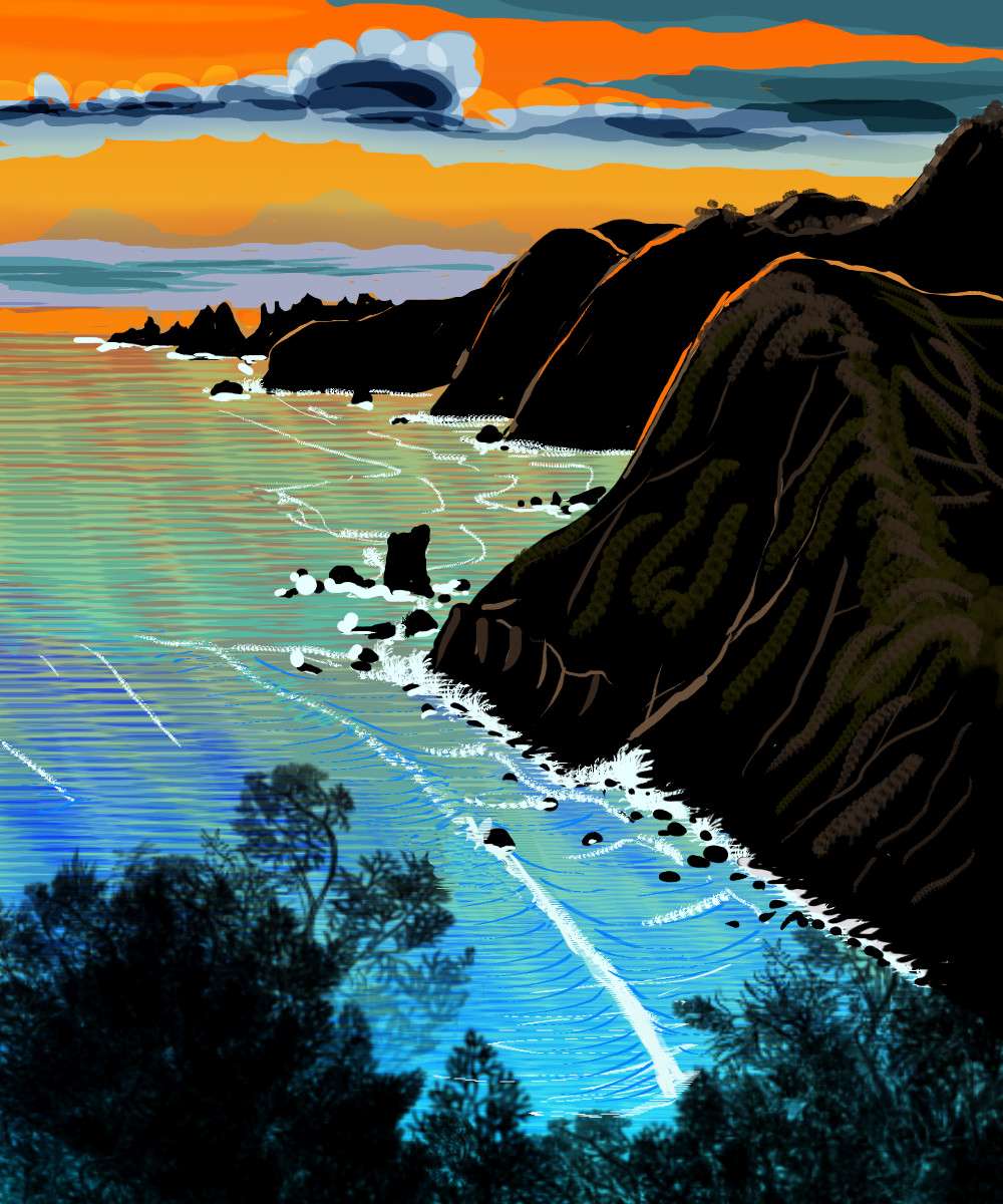
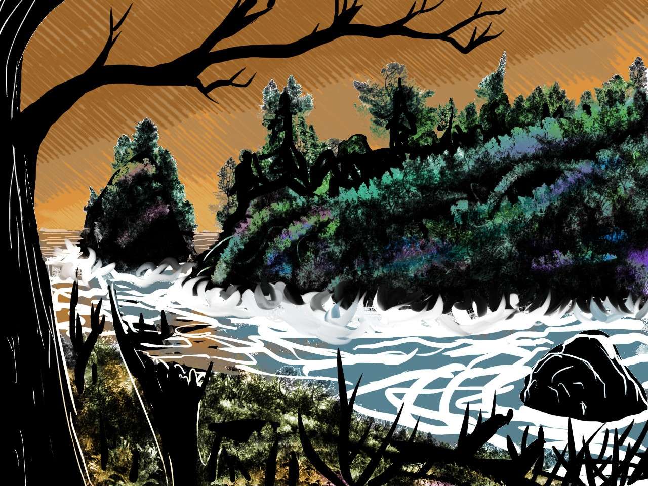
Sunset, Cape Koonalda, looking west to C. Discord (on horizon) Sketch by Wayan after 'Muir Beach', a print by Tom Killion |
But between the Bight and the Tasman Islands is a biological barrier--the Tasman Trough, up to 7 km deep (23,000'). That deep water gives no hint of the land beyond. And the Trough is wider than the Banda Strait in the north. The Tasman Trough will be a biological barrier like Wallace's Line in our Indonesia--a moat between very different biological worlds.
If Whartonia is settled from outside, it's unlikely Agassiz will be first. The opposite, of course, is true too. If Whartonians--whether flightless birds or centauroid mammals--spread via rafts and crude boats, they'll discover the equatorial straits first, I think--first by millennia. Until deepwater sailors appeared, a mere millenium or two ago, the Tasman Gap was absolute.
As a result, the Bight is largely settled by equi from the Tasman Archipelago, a robust, athletic subspecies tolerating cold, rain and shady woods better than their ancestral stock on the savannas of Agassiz. They still prefer open country, but not so much so that they'll go to the work of clearcutting and farming it human-style!
It's true that the densest equi population on the Bight is the inland valleys; they run north-south, across the prevailing winds, and the mountains ridges around them catch the heaviest of the generous rains (and snows) of this temperate region, leaving the valleys sunnier; not pure prairies, but a patchwork of grove and meadow pleasant to the Tasmanian eye.
THE SOUTH COAST of the the Bight is dramatic, and quite unlike the north, or the meandering ridges and valleys of Perthia. It's an endless sequence of south-reaching capes, islands and straight "fjords", often cliffwalled. These are caused by fracture zones of the sort more typically found flanking the Atlantis Rift, in Atlantis, Azorea, Pernambuco or Angolia.
On Earth, this violent stretch is atypical for the eastern Indian Rift--generally a smooth rise--so it's called the Discordance. Not an inch of it breaks the surface, though--not even close.
But it does on Abyssia! Tentacles and island chains trail over 1600 km (1000 mi) south from the Bight, as if it's a monster jellyfish trolling for Antarctic prey.
These peninsulas are temperate to cool--warm summers but consistent deep-winter snows even at sea level, even if they're not always long or heavy. Out on the Islands, or in the mountains, they often are.
Looking at the eastern tip of the Bight, its name seems more appropriate: just apply it to the south shore. Raggeder than its Australian source, but that's one huge, shallow curve. From Cape Koonalda to Point Toogee--the Great Whartonian Bight!
Islands dot (and shelter) this great gulf. Not a bad place to learn serious seafaring. So I have no doubt, once the tradition's established, that small ships will venture south past Cape Koonalda to discover...
Introduction - Coasts & Names - Holes - The Moat - Peoples - The North - Perthia - The Bight - The Discordian Isles
These scattered, cool green islands have rocky cliffs and precipitous ridges. Dramatic! Think of them as Tasmania after its mandatory break-up under the Scenic Antitrust Act. Tasmania's scenic wealth... but broadly distributed. Very broadly indeed: the Davis Rise, south of the Bight, is a flooded continental plate thousands of km wide--much like the Bight, nearly as big as our Australia, but a few hundred meters down in most places.
On much of Abyssia, land doesn't have to happen; it can be built. If Davis were tropical, enough light'd penetrate to the floor so coral could build reefs right up to the waterline; the whole rise would be a maze of atolls--a super-Barrier Reef. Too cold for that down here! And at this high latitude, the low sun reflects off the gray seas; it's dim down there. Flourishing reefs, yes, but not very fast-growing corals.
Still, coral's not the only way to form islands in water this shallow. It doesn't take much compression or fracturing or vulcanism to break the surface, and we are near the Indian Rift, that engine of change. So scattered clumps of islands stretch all along the south edge of the Rise--just nothing continental.
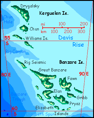
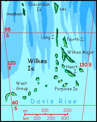
Hmm. Maybe they're more Aleutian than Tasmanian. The Davis Rise stretches a long way south! The Wilkes Islands approach 60° south, and the Pobeda and Banzare Islands, to the west, actually reach 60. Not far from our Antarctic shore. Brr!
But this isn't Earth. Abyssia lacks that Antarctic icecap generating the savage katabatic winds that blast our southern islands. Davis's scattered isles are cool and rainy in summer, snowy in winter... but more Baltic than Antarctic. The twin Discord chains and Heemskerck are milder still, British (or British Columbian): rainy, with titanic evergreen forests on the larger islands.
And they do get large--they may seem mere specks on the location map, but the Davis Sea is continent-sized. Drygalski in the Kerguelen Group, Great Banzare and Rig Seismic and Fawn in the Banzare Group, Heemskerck (going it solo), Wilkes Major, and Discordia itself are all 80-160 km long and 25-50 wide (50-100 by 15-30 miles); and twenty more are half that size. The southern isles' woods grow low and dark, but only the smallest lack trees, and even these have grass, bracken, and brush--full of berries by late summer. Lonely, yes, and rainy, and you need a warm coat (or the fur or feathers of native Abyssians) to get through winter, yes, but these aren't bad places to live.
It's true that some of the Davis Sea archipelagoes really are mere islets--not one spot in the whole Pobeda Group is over an hour's walk from the sea (or would be, but for the cliffs).
But even the Pobedas aren't barren--and on Earth, they would be.
Abyssia's homepage - map - peoples - regional tours - names
LISTS AND LINKS: More worlds? Planetocopia! - dreams of other worlds - ecology - climate change - evolution - natural disasters - terraforming - sculptures and 3D art -
World Dream Bank homepage - Art gallery - New stuff - Introductory sampler, best dreams, best art - On dreamwork - Books
Indexes: Subject - Author - Date - Names - Places - Art media/styles
Titles: A - B - C - D - E - F - G - H - IJ - KL - M - NO - PQ - R - Sa-Sk - Sl-Sz - T - UV - WXYZ
Email: wdreamb@yahoo.com - Catalog of art, books, CDs - Behind the Curtain: FAQs, bio, site map - Kindred sites