Capsica's homepage, map, giant ref map, geography, gazetteer . More worlds? Planetocopia!
 Capsica: The Arch: Central
by Chris Wayan, 2019
Outline only!
Capsica: The Arch: Central
by Chris Wayan, 2019
Outline only!
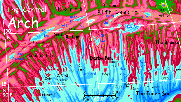
The Arch is a crustal spreading zone like Earth's mid-ocean rifts. But Capsica's shallow seas don't hide this huge structure underwater--or not much of it. The rift has two ridges flanking it, where the crust upwells; these wander, parallel, like the rails of a gigantic train track. The rift between is mostly desert and salt lakes--cut off from rain, and the sea, by the flanking ridges, the North and South Rims.
This tour covers the central Arch south of the Rift. In general it's hot and dry, though the south coast has a weak summer monsoon; inland, to the north, valleys and lowlands are quite dry. Savanna and desert. Fortunately for your survival, the region's rugged; the South Rim of the Rift reaches Alpine heights, snagging clouds and wringing enough rain (of course not snow) to sustain woods--and cool enough to sustain Terran travelers too, though just barely, and only in winter. The lowlands, wet or dry, summer or winter, are hot even by Capsican standards, and fatal to Terrans most of the year--40-45°C (104-113°F) in winter and up to 65°C (149°F) in summer.
Rule of thumb in the Arch: if it's green, you'll find it warm; olive, hot but survivable. Red? Fatal.
Dozens of ridges and sounds radiate from the rift at right angles; these are fracture zones, where the plate, spreading at different rates in different sections, grinds and slips. Such fractures dominate the region, defining the coastline, deciding where rain will fall (or won't, mostly) and where most of the population lives, creating long updraft-corridors the locals use for flyways, and, incidentally, creating cooler highlands that Earth tourists can bear in winter, largely determining our tour routes.
The Arch breaks into larger segments than these ridges. Every 500-1000 kilometers (half a dozen to a dozen ridges) there's a major fracture--a deep sound, a thousand-km mountain range, or both, and then another miniplate with its own drift-speed, altitude, even its own chemistry. This too is an Earth phenomenon, but more visible on drier Capsica. You can see five such blocks along the south coast where the sea brings out their differences:
The only practical route through the region for Terran tourists in strap-on wings is to follow the South Rim of the Rift. We'll start in the west and head east...
Central Arch: Intro - West - Middle - East
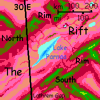
You're on the green-forested South Rim of the Rift, looking down on distant Lake Parnaa, having flown here from the Western Arch. Parnaa is leaf-shaped; the 'stem' and central vein is a trench some 250 km long (150 mi), with mineral vents and hot springs. The wide lobes of the 'leaf' are quite shallow. There's no outlet; so it's brackish and seasonally varies from 120 to 145 km wide (75-90 mi); the length is relatively stable. The shores are dry even for the Rift; rain is rare. And this desert floor is unusually wide here, unpunctuated by cooler mesas, volcanoes or ridges common in some other stretches; you won't be crossing that scorching pink flat to the north. The only way is east.
Luckily, east is easy--for the first thousand kilometers at least. The South Rim here is a plateau 3-4.5 km high (roughly 10-15,000'). The valleys to the south, running down to the sea, are dappled with groves and meadows--at first. As the days pass, trees huddle and shrink; the grasslands grow. We're not just heading east but subtly north, too; as we creep out of the equatorial zone, less rain.
The highland's not utterly continuous. Every few hours, a deep canyon or broad fault-valley shimmering with fatal heat below you, marked by the lurid reds and magentas of rhodophyll trees. But such gulfs are never more than an hour's flight across. Good practice, though; in the weeks to come, you'll need to make longer flights over deadlier territory.
Four days in, you reach Lirru Peak, 4.8 km up (16,000')--the highest point for 1000 km. The coldest, too: 25°C, (77°F) now, in winter. From the peak you can see a silver gleam far to the north--not a mirage in the lowland heat, but the Sea of Flies, 110 km off. Keep it that far. They mean that name.
After Lirru, you cross one more narrow canyon-gap to the Diseti Mountains. Lower and hotter, rarely much over 3300 meters (11,000')--you see more red trees now among the green--but an unbroken ridge running all the way to the Tsora Lakes, 2000 km east (1250 mi). The first day, the Sea of Flies recedes to a glint and vanishes. Desert north, a spotty green plateau a mere 20 miles wide, and long savanna valleys to the south.
Next day, a redder gleam in the north: the marshes and woods around Tillet Lake. Since it drains into the Sea of Flies, it's freshwater; an oasis in that ovenlike desert.
Past Tillet Lake--takes most of the day. It's just 50 km wide but 225 long (30 by 140 mi).
The next day, you need to veer south to avoid the North Spur--here a ridge wanders off into the heart of the Rift. It's the best spot to cross for thousands of km. Locals and even some tourists ride the Spur to the northern Arch--cooler, greener, a little more Earthlike.
I did say "a little".
Instead, you head due east on the southern fork of the Diseti. Higher, greener, cooler--no rhodophores at all for hours, just green Earthlike woods; altitude 4.4 km (14,500'). I recommend you veer a bit south, to the southern drop-off. Rumpled ruby valleys. That gleam to the south is ocean! The head of Nesh Sound. You're in a different mini-plate here, where the land is lower; the fracture-zone 'fjords' south of the Diseti Range bite deep into the Arch.
Despite this, it's savanna and even semidesert down there. Most winds come from land. Only an unreliable, brief summer monsoon brings rain.
For a month or two.
Most years.
If it feels like it.
The land slowly, subtly turns grudging. Out on the capes it's still Mediterranean. Well, oven-hot Mediterranean, but Capsica's version. The inland valleys get harsher, though.
Central Arch: Intro - West - Middle - East
Veer right for a couple hours over a little green-forested highland that could be Terran. An abrupt rim to the south. That other gleam on the southern horizon? Not the sea. Freshwater. No, we can't go for a swim. Bath-hot, and the air's hotter. Lake Dirak's the heart of the Darbo Peninsula, a big blunt tongue bigger than Texas: 900 km long and wide (570 mi). Darbo's formed by the fusion of at least ten north-south-ridges--a fracture zone that, unlike its neighbors, rides too high for the usual "fjords"; lakes at most. The ridges are often wooded--red foothills, olive summits; true green on the high South Rim of the Rift, at Darbo's base--but the valleys are hot dry grassland, even desert in spots. Monsoon rains from the south are unreliable; the Rim blocks winter storms from the north; east and west, too much rugged land blocking rain. Only the ragged south shore, plus Dega Island and the Rokos, are very fertile or populated.
North again for two hours; here the Diseti Range is no mere ridge but a plateau 160 km across (100 mi). At last the Rim drops away into the Rift. The desert below is lurid--salt and alkali flats around Salt Lake. This is one of those forks in the Rift I mentioned earlier. There's a parallel valley to the north, past the North Spur. Hot, dry, but not salt-poisoned like this one. It's open to the west and drains to the Sea of Flies, where this one's blocked, a basin.
On past. Dry basins on both sides now, and the ridge narrows and lowers, just 2.5-3 km now (8-10,000'). Am I leading you astray? Ahead on the right, a similar ridge intersects this one. As you near, you find distance flattened the true situation: it angles back southwest. Counterintuitively, this is our flyway! Our current ridge really does trail off in the Rift--though close enough to the North Rim for local travelers to use it frequently. But this backtracking ridge curves south then southeast. Narrow and broken. Below, to the east, is a THIRD fork of the Rift: the Tsora Basin. Three lakes, draining northeast--the last, though, is a dead end: salt. Invisible over the close horizon, but you can see Upper and Middle Tsora.
Southeast... after a dull sweaty day of hopping between dull-green mesas above dull-pink semidesert, West Hwo Lake is temptingly close below you. Clearly freshwater--a blue eye inset in pink grass, lined in red trees. Fatal, though. Like most of Capsica.
Now comes the tricky part of the trip. East all morning, then sharply south in the afternoon. Water to the northeast--East Hwo Lake--and southeast--Hwo Sound. Yes, the sea. And it's in the way.
It'll take some planning to get you alive across the strait.
Central Arch: Intro - West - Middle - East
A hard night-flight across Hwo Strait. 150 km across (90 mi). And if you get tired, you don't just drown, you hot tub to death...
Hwo Bay, center of the south coast. The only place where the sea laps the Rim--inside the Rift.
Out on the Peninsula. Here fracture-zone ridges are raw and vertical indeed; escarpments everywhere.
Two days later? Ahead is winding Linsa Sound.
Cape Telisto and Brrn Island? Way more fertile than the north, but it's not for you. Too low, red, hot.
Back north up the peninsula's eastern ridge, called, imaginatively, East Ridge.
Mesa-maze; plateau, though much of it's just a mile or two up, uncomfortably low for you. One ridge leads south to a splendid lookout over Roi Sound. Orchards, ports, fishing boats, beaches... a maritime Mediterranean climate much nicer than the north.
But you can't swoop down to sample it. Unless you like it at 45°C (113°F).
Our way zigzags northeast--well, overall--toward the South Rim again, though here it's a bit unclear which mesas count. This region's call the Breaks; mesas and ranges just trail off into the desert of the Rift floor.
At the northern edge of the Breaks, you face a choice: fly north over the desert to Mt Artho--long and hazardous, but after crossing Hwo Strait, you may be able to make it. Then on north into the Notahi Peninsula, (blessedly cooler, almost Earthlike, except for the Martian volcanoes, so immense they have actual snow...
Or... you ride a thermal east into the Breaks and on along the Northeast Arch to the strange Tlasi Calderas.

World Dream Bank homepage - Art gallery - New stuff - Introductory sampler, best dreams, best art - On dreamwork - Books
Indexes: Subject - Author - Date - Names - Places - Art media/styles
Titles: A - B - C - D - E - F - G - H - IJ - KL - M - NO - PQ - R - Sa-Sk - Sl-Sz - T - UV - WXYZ
Email: wdreamb@yahoo.com - Catalog of art, books, CDs - Behind the Curtain: FAQs, bio, site map - Kindred sites