Capsica's homepage, map, giant ref map, geography, gazetteer . More worlds? Planetocopia!
 Capsica: East Arch (south of the Canal)
by Chris Wayan, 2021
Outline only!
Capsica: East Arch (south of the Canal)
by Chris Wayan, 2021
Outline only!
Introduction - Touring - Strait - East Rim - Mt. Forja - Rift Crossing - West Rim - Canal
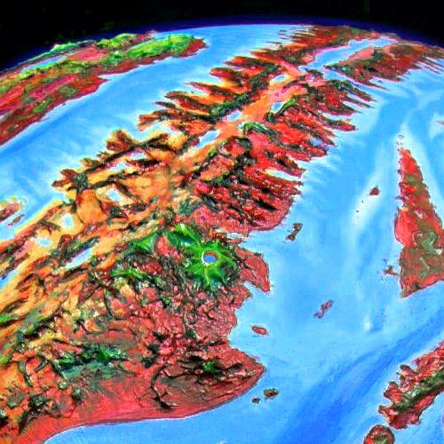
The Arch is Capsica's largest spreading zone, where new crust emerges from a rift. This valley, thousands of kilometers long, is flanked by twin ridges, typically 3-4 km high (10-13,000'); around these are a maze of lesser ridges, as the new crust meets resistance from older plates, and corrugates. It's not simple folding, either; parts of the rift spread at different speeds, and the boundaries between these conflicting conveyer belts (called fracture zones) rub and grind, pushing up lesser ridges and valleys at right angles to the Rift. The result looks like a ruined city built by giants, full of gaps in the walls and barriers blocking the ancient streets.
In short, it looks... fake. But in fact, Earth has millions of square kilometers of terrain like this! It's just nearly all hidden under miles of sea. This stretch is quite like our Mid-Atlantic Ridge--but on Capsica, with its lower sea levels, these weird landforms are exposed.
In some stretches, both on Earth and Capsica, hot spots break through this rift-zone labyrinth, building shield volcanoes; if persistent enough, a hot spot can build a whole chain of monster peaks or (if the local magma has a lower melting point) low but immensely broad calderas. This eastern region has a modest example of the former at its south end; Mt Forja is a near-twin to our island of Hawai'i--if you exposed the undersea part too.
All of the Arch is a spreading zone--its crust is new, moving a lot, subject to quakes, full of faults and fissures, volcanoes and geysers and hotsprings. Is this changeable, harsh topography hard on life? Well... not very. Since about 30% of Capsica's entire land area is corrugated rift-zones, life is used to these conditions. It's just that you won't necessarily be.
The north end of this stretch is the lowest and narrowest in the Arch; so low that near the equator the rift's east rim was breached by the sea. Not far away, the west wall is so low that two sluggish rivers nearly meet. Here, a canal is under construction. At present, only modest boats can cross, and in the dry season, only small craft. But eventually the Arch Canal will shorten major shipping routes by up to 30,000 kilometers (19,000 mi)--quite as important for Capsica as the Panama or Suez Canals are for Earth's economy. Not for news or passenger travel, of course; in Capsica's dense air and low gravity, everyone NOT carrying tons of lumber or iron travels by air. Ten times faster!
Intro - Touring - Strait - East Rim - Mt. Forja - Rift Crossing - West Rim - Canal
If Capsicans were human, the endless fractal capes and 'fjords' walled off by high ridges would isolate each community, discourage land-travel, and encourage sea-travel. It did in Norway--and Hawaii. But Capsica has low gravity and dense air. Flight is easy, even for human-sized creatures. So the dominant life-forms will almost certainly be winged. For them, those wind-catching ridges are flyways! Those that stand across the wind create reliable updrafts stretching for days of easy travel. The ridges flanking the Rift, especially, are transcontinental freeways. From them, fracture zones offer 'onramps' and 'exits' leading to other continents. This huge, simple, consistent flyway system, way more regular than the Outer Hemisphere's spotty flyways full of gaps and sea-passages, led the Arch to dominate culturally for centuries. Communication is civilization!
Humans are weak and lack hollow bones, but in this gravity, in this air, with strap-on wings you can fly. Not elegantly, not strongly; I'll forbid some popular native routes you can't handle. But you can get around. That's good, since Capsica lacks passenger transport--shipping is well developed, but it's almost exclusively cargo. Fliers get bored sailing at a tenth or twentieth the speed they can sustain under their own muscle power. Even you, riding updrafts, should sustain 50-80 kph (30-50 mph); ten times walking-speed, way faster than a bike or ship; comparable to car or rail.
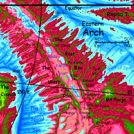
I'll start this tour in the northeast on Seluria Strait (near horizon; blue tongue inside the Great Rift), down the east rim of the Rift to Mount Forja (greenish volcano in the foreground), then west across the Rift, and back up the East Rim to the Canal, Capsica's greatest civil engineering project--a river-linkage will eventually let cargo ships cut up to 30,000 km (19,000 mi) off the torturous route up from the Crunch and Inner Arch to the Outer Hemisphere.
Intro - Touring - Seluria Strait - East Rim - Mt. Forja - Rift Crossing - West Rim - Canal
Seluria Strait is quite crossable--just not easy. Only 50 km of water, but over 100 km from highland to highland--and you can't survive the lowlands, not here near the equator.
By day, the deep sea is cooler than the land. That sounds good, but isn't. Cooler air generates downdrafts. You'd have to cross on musclepower alone, fighting this down-current. And it's still hot enough down there to kill you--50°C instead of 60 (122°F, not 140). Slow death instead of fast.
So... we'll cross at night. The temperature difference between land and water shrinks and vanishes; the air calms. Night-breezes blow toward Torlash Sound, a mere crosswind, nothing hazardous.
Still a long way, but at least now the landscape, or rather airscape, isn't sabotaging you. It's just an endurance contest--miles versus muscles.
South of the Strait you reach the Belnar Hills. I advise you to camp and rest up a full day. You need to. Sore shoulders. If they're really sore you can always drop from the peaks (3.5 km, 11,500') down a kilometer or and sit in a creek for an hour. Might as well be a Terran hot tub. Bake that soreness out! Just don't overdo it and die. Remember the air's even hotter and too humid for much evaporative cooling.
When you're healed, up, we'll try an easy flight: half a day south, over steamy red-forested lowlands and high green mesas. This stretch of the Rim, south of Seluria, is intermittent; passes well under a km (c. 2000'), heights over 3 km (10,000'), like the Belnar Hills again.
In the East Lirwa Hills, native travelers not touring up and down the Rift like you but going straight to the Canal, all peel off west, heading across the Rift. But that's another tour.
To your right, the Lirwa Marshes, a scarlet plain full of winding turquoise veins and pools; the Lirwa River drains great marshes and savannas to the south. The influence of the Sound--over 1000 km of sea--goes deep inland up the Rift. Lakes, marshes, patchy woods and healthy savanna for days... no desert.
Those hills on the horizon, capped with dull green, aren't the West Rim but the Center Hills; here the Rift apparently splits. Hidden beyond is Chabi Valley, lilac grasslands with a red strip down the middle where the river drains two great riftlakes, Chabi itself and Karok upstream. Between, this narrow ridge of cool green forest. Cool being a relative term.
Many locals flying south along the East Rim peel off here, crossing the marshes to the Center Hills; they're the highest, coolest, easiest flyway across the Rift for thousands of kilometers. This is the equator, and hot for Capsicans too. It won't kill them down there, but they too appreciate these cool heights.
For now we'll stick with the East Rim. You can see our immediate goal for a day ahead--a huge pale-green tooth floating to the south: Mt Elkani.
For two days, you cross deep, fatal red gulfs to sky-islands of dull green. The first night you camp hot--barely in the safe zone, right at 3 km (10,000'). Here so close to the equator, that's rough. Not just heat; humidity. Many of the flyways I steer you to, being high-altitude, are (if not above the clouds entirely--Capsica's dense atmosphere and low gravity let cumulus mount miles high) somewhat drier. This low, and you're barely above the cloud-forest zone. Clammy. Bad sleep.
Next day is easier. The East Rim turns almost continuous, and runs higher, nearly 4 km (13,000'). Higher, cooler, and... well, not dry at all, but less drippy.
Ahead is Mt Elkani, the highest volcano in the Straits region, 5.3 km (17,500'). Relief. You camp on the shoulder near 4.6 km (15,000'), below the sharp, broken summit. That ragged canine tooth tells you Elkani has been higher, in deep time, but blew itself apart...
Not a new story here. Half the peaks of the Rift have built, destroyed and reinvented themselves. As bad as celebrities.
Intro - Touring - Strait - East Rim - Mt. Forja - Rift Crossing - West Rim - Canal
Onward from Mt Elkani. Travel is easy here; the rim is high, updrafts strong, temperatures here in global winter at 4 km elevation around 35°C (95°F). Frequent rests in green woods offering shade and swimmable creeks. Even to the west, green ridges, not the Rift floor. This junction of highlands is where that central ridge re-merges with the East Rim. An hour or two where you really couldn't prove you're not on Earth--except, of course, for the gravity. You're flying around using wings far too small to work back home.
In the afternoon the Terran illusion evaporates. Back to Capsicality! On the right, scarps drop 2.5 km (8000') to the Rift floor--a lurid pink. Visibly not Earth.
A silver glare all afternoon off Lake Chabi below. 200 km long (125 mi) and freshwater--Chabi drains to Torlash Sound far behind you now. Huge marshes of purple reeds...
As the hours pass, the lakeshore marshes recede into the distance; the Rim here veers slowly east, farther from the lake. Late in the day it's just a smudge on the horizon. But at sundown, when you camp, the lake reappears briefly as a fiery sunset reflects off it. That streak of flame on the far horizon could as well be a mirage--if you hadn't flown alongside it all day.
Next day history repeats--only more so. Lake Karok, a kidney shape 160 km long and half as wide (100 by 50 mi) nestles tightly under a curving stretch of the East Rim. True cliffs in many places, rising to 4.3 km (14,000'). Reedy, wooded lakeshores, for Karok, too, is freshwater, draining northwest into Lake Chabi. No unstable shores, no salt-poisoning! Drainage matters. Even away from the lake, the Rift here isn't desert--not yet. Dry pink savanna. The influence of Torlash Sound and Lakes Chabi and Karok is waning but still there; all that surface water humidifies the winds. Rains on the rift floor around the lakes are scarce but enough to sustain grass.
Near the lake's south end, you camp on the Karok, a point like a ship's prow, 4.8 km high (15,800'). Fantastic views of the green world up top and the lavender abyss. Breezy, pleasant--barely 30°C (86°F).
But this is the end. Past the Karok, the rift floor turns grim. High mountains on each rim here block nearly all rain. Rust, tan, gold--bare rock and even sand dunes below you.
Paradox. The same unusually high ridges that are keeping you relatively cool and comfortable here (well, not dead, anyway) so dangerously close to the equator, and even closer--just three vertical miles--from that oven-hot desert, also block all rain, creating that desert.
A day or two down the East Rim. The only water here's on the heights. This stretch too could almost be Earth (aside from the gravity). That relentless Capsican pink is gone--just a few lurid traces along watercourses fed from above, and you can pretend those streaks are spring wildflowers. Green above, brown below. Could easily be Owens Valley from the Sierra Nevada, or the Taklamakan Desert from the Tien Shan--except you're flying, not caravaning down the Silk Road.
A change at last--the streams from the heights collect into another riftlake--East Lake. A big blue almond eye, with red lashes. Reeds, even trees on the shore! Fresh water.
Why "East Lake"? You can't see, but over that ridge behind it is a twin. Only West Lake wasn't so lucky. Its basin is a bit lower, and runoff from East Lake winds north around a low mesa and into West Lake, while a spur of hills cuts off the twins from Great Salt Lake to the south. With no outlet and high evaporation, West Lake is quite salty. Worse, the shoreline shifts--seasonal flooding plus plus multi-year cycles of drought and rain. A wide band around the lake is salt-poisoned ground.
Let's leave it unseen. Halophilic bacteria color West Lake a lurid yellow-green lake, impressively weird for Capsica's lowlands--but the shores stink.
South away!
A few uneventful (but at least not stinking) days down the East Rim above the Great Salt Lake. While saline, it's fairly stable, and supports saltmarshes along its shores, shrimp in the shallows, fish in its depths, and flocks of lemon-yellow flamingos. Yellow? Of course yellow. The least natural color on Capsica, thus the most visible; being fluorescent pink on this planet is practically camouflage. Here, as on Earth, these lurid flamingo colors didn't evolve from natural selection at all; it's from a pigment in the shrimp they eat. Now the Salt Lake Shrimp do use the color for visibility and to impress mates, so it's still all about showing off... just at one remove. As if the grizzly bear that ate you also put on your sunhat to impress the other bears.
Skeptical that diet can change a creature's color? Try an all-carrot-juice fast for two weeks! Or just eat ten a day. Your palms and soles will turn quite an amazing orange, and your entire skin may tint visibly. I speak from embarrassing experience. There's a book about Women Who Love Too Much, but none about Creatures Who Love Carrots Too Much. I'd have been warned.
Anyway, the pseudo-flamingos that elsewhere look offwhite or pale pink are screaming yellow here. You can see their flocks from two miles up on the Rim.
It's a Fauvist planet.
But all psychedelic eye-searing palettes come to an end. Time to leave the Rift at last! We need to. The next stretch sags to just 2.2-2.5 km high (7-8000'), too low and hot for comfort. Cross the forested heights of the East Rim till it drops away into a savanna valley, shimmering in lavender and pink. Head east toward the next wooded ridge, blue-green in the distance: R'sherp Ridge.
Intro - Touring - Strait - East Rim - Mount Forja - Rift Crossing - West Rim - Canal
You're on R'sherp Ridge, paralleling the Rim, but higher and greener--more rain! R'sherp partially rainshadows the East Rim proper. The forests of R'sherp offer shade and water, but aren't quite as pleasant for Terrans as the Rim was. Yet they're 3-4 km high (10-13,000'). No hotter, but muggy. Still, you can swim to cool off, and camp anywhere, even if sleep's fitful. At least the local bugs don't recognize you as food. There are benefits to being cold and smelling weird.
The land to the east looks healthier than the Rift--deep magenta forests in the hollows, olive/mixed cloudforests higher up, white cumuli bumbling around the green peaks. But you're not Capsican. This rainier zone is, for you, worse not better. Nearly as hot, but way more humid--the worst so far on this trip. The highest temperature you can tolerate drops from 40°C or so to just 35 (104°F to 95). And it hits that most afternoons.
A long day down to the southeast tip of R'sherp Ridge. Take breaks and swim frequently. Camp at the tip--you can't miss the dropoff.
At dawn, hop southeast again, to lower, confusing washboard hills. As the Rift spread, this fractured region just crumpled. Still is, in fact.
Low, hot, miserable, the woods not even green--you're down in the olive zone. But the hills slowly climb, and by the heat of afternoon you reach their summit, 3 km up (almost 10,000'). High enough to be endurable. Rest up. Tomorrow's the last hard bit. You can see your goal already--that massive cone ahead, Mt Fyuuz.
In the morning, you cross a red lowland, fatal to you, but (you notice) not as dense or steamy as a few days back; even open meadows here and there. This stretch of forest is in a rainshadow cast by a single monstrous mountain you can't even see yet--Mt Forja, ahead. But it's still hidden by...
Mt Fyuuz. Relief! Its windswept alpine meadows stand out for hundreds of kilometers as a pale green sky-island above pine-green ridges and deep red lowlands. Those white streaks above you on the summit? SNOW! And why not? It's winter, you're creeping out of the equatorial belt at last, and Fyuuz is 7.5 km high (24,600').
Camp, rest. Look back across the salmon-red basin at those crumpled hills. It may be creeping upward instead of east like most of this country because the great volcanoes are in the way--not only do they cast rainshadows, but bow waves, like boulders in a rapid. A rapid made of stone, moving just a meter per decade...
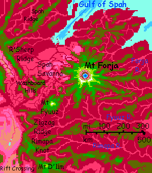
Next morning, ride the winds round the northwest shoulder of Fyuuz--it'll take till noon, this is no hill! Now you see the real giant, Mt Forja, to the northeast--a high, white-capped, Kilimanjaro-like wall ahead. Up a long winding ridge to it, but it seems to take forever...
That's because it's even bigger than you think. Mt Forja's a shield volcano 9.7 km high (32,000'), nearly as big as the island of Hawaii, and it feels even bigger, as it's fully exposed, head to toe. It's a bit steeper too, with slopes of 15-20°. Capsica's low gravity allows steeper slopes in general. Now, in winter, snow blankets Forja's southern shoulders and even streaks the sunny north.
You'll have to hike up to see the summit--while the air's quite breathable on Capsica six miles up, you can't fly in it. But it's not steep, and the sight is worth it. The central caldera is Martian in scale--nearly 100 km wide (60 mi) with cliffs 3-4 km high. A deep indigo lake fills much of the caldera floor.
Though taller, Forja is slowly eroding now; Fyuuz is younger and more active. The hot spot that created both is now right under Fyuuz; eventually it will grow to dominate the region. The hotspot hasn't moved, of course; the land around you has. Relentlessly creeping northeast, out of the Rift.
Back down to your base camp, where you left your strap-on wings. No, no one stole them. Silly human! They have their own. Nobody wants your crutches...
Next day, glide round to Forja's northern shoulder. Silver gleams on the northwest horizon: the Gulf of Spah. It's the first sea you've seen since Seluria Strait. In general, this stretch of the Arch is wide; few sounds reach far in. Spah is a vigorous exception; and a matching sound on the west rim mark this as a fracture zone, a border between stretches of new crust spreading from the Ridge at different speeds.
Today you must dodge south on a zigzag ridge called Zigzag Ridge. A writhing Chinese dragon of green woods rising from a sea of cloud. Cracks in the mist open and there to reveal dim plum-purple valleys of rainforest far below. In this muggy heat, it looks cool and pleasant down in those shadows. It isn't. Do NOT go downslope unless you want to learn what the cookery term parboil feels like. Just swim in the tepid creeks up here and be grateful the dragon's there at all.
Intro - Touring - Strait - East Rim - Mt. Forja - Rift Crossing - West Rim - Canal
I've been leading you on detours for a reason. This region, disturbed by the hot spot under Mt Fyuuz, is what geologists call a "mess". Natives can fly across the gaps, but for tourists, there is no simple, safe flyway here. I'm trying.
A day later, the ridges rise, but grow more random--all directions, a rat-maze. This is the Rimapa Knot. Chaotic, yes, but cooler and more comfortable, rising to as much as 4.6 km (15,000'). Just keep southwest as well as you can. You'll know when the Knot ends. When...
A pale sandy abyss yawns under you--the Rift! You can't see any far side--just desert lowland. Yet this is the best place to cross the Rift in a couple of thousand kilometers.
I said "best". Not "good". If you don't want to cross, you can go on south, on this rim, all the way to the Antarctic. But the Southeast Arch is another tour.
Camp and rest. You'll need your strength tomorrow.
We have to proceed in hops. Out in that desert are scattered mesas, some high enough to be capped in open, olive woods. These are our stepping stones. You may be picturing this like the Grand Canyon. No. These mesas are miles apart with dusty barrens plains and low cindercones between them. No rivers, no streams, not even much dry grass. The dull olive of the scattered trees atop the few mesas are almost shocking--the only things in sight that aren't brown.
Though these sky islands are hot, they're at least less muggy. At this latitude (20°S), storms come from the east; the west, being downwind, is drier.
By the second day and third mesa out, the Knot is invisible behind you; you're perched on a crew-cut giant's head of gray stone in the middle of a tan nowhere. And this is just the fringe of the Nigavni Desert; it runs all the way to the west coast, and south for 2000 km (1250 mi). Not a comfortable place. Or a safe one.
Luckily you find a small spring--only it's not luck, there's a huge water-glyph scrawled on the cliff above. This crossing's hard on the locals too. Signage helps.
Top off. It gets worse tomorrow.
At dawn you turn sharply northwest. Though it doesn't seem like it, this modest mesa, so like the rest, is part of the West Rim--a saggy part. A strenuous day, following a long but low ridge, so low its few trees are mostly red. Nowhere you can camp or even rest safely, all day. Near sunset it rises into olive-green hills, hot but bearable. Land and try to sleep. Hot night, but dry heat. At last you sleep.
Next day it rises. And rises. And rises! Luckily those winds from the east hit this wall and are forced up; you don't have to climb this rise on musclepower, just grab the updraft. By sunset, you're over deep green forest. Find a creek. Wash the salt off. Camp in shade. Bed early. A cold night, unnaturally so, you feel; by midnight, it drops to 25°C (77°F). Well, cold for tropical Capsica, yes. But you're in late winter at 4.6 km (over 15,000'). What's happened is, your inner thermostat went bust.
Still, you're alive and safe on the West Rim. I call that a win.
Intro - Touring - Strait - East Rim - Mt. Forja - Rift Crossing - West Rim Canal
Northwest along a high, cool, green ridge. Tan desert two miles below on your right, streaked with white: salt pans. To you left, a mile below, pink and lilac savanna, veins of red trees, growing denser out at the horizon. Around sunset, between clouds, a fugitive gleam of silver out west--the head of K'nik Sound, a fracture zone--probably the same one that created, on the far side of the Rift, the Gulf of Spah.
Two days past the Great Salt Lake, distant but visible.
Next day, empty desert below; a chartreuse peak above, Mt Kolba, 4.9 km high (16,000'). Not a volcano for once; a great basaltic chunk or slab tilted and squeezed up out of the general corrugation and chaos of this fracture zone. Camp on the shoulder at a woods' edge overlooking what could be subalpine meadows on Earth. A mere 30°C (86°F). And cooler at night.
Then a day passing West Lake, fortunately at a distance: out on the dull orange eastern horizon, a charming avocado bacterial smear. Up here you don't smell a thing.
A day of desert below. But this one's not dull--it's ominous. The West Rim starts to narrow and sag. You camp before it drops you into olive woods, or worse.
Cross a gulf 80 km across (50 mi)--a box canyon of brown scrubland with pink veins where draws collect scant seepage. It's all a mile beneath you. Ridges here are broken and just 2.5 km high (8000'); too hot to camp on, and little water anyway. Push on--the main ridge you seek is to the west.
Woods! Water! Cool heights! Well, cool as in 35°C (95°F) and heights as in 3.2 km (10,500'). Not ideal, but decent.
Two or three more days along such ridges. Both east and west, savanna not desert; we're creeping into the rainier equatorial zone.
Next day, a silvery shimmer to the north. A big shimmer. To the horizon. That's no narrow riftlake. The sea? Have we come full circle?
No. Its shore, wide purple marshes dotted with red trees, suggest that's freshwater. Huge Lake Chabi, not the sea. But its freshness is precisely because this is the first lake on our journey north that CAN drain to the sea. It's coming.
Here a lot of fellow travelers--both locals and tourists--peel off and head into the fracture-zone ridges southwest of Chabi, toward Mako Strait, the narrowest and easiest passage out of the Arch to the Crunch for 5000 km. Narrowest does not mean narrow; easiest does not mean easy. Stick with the Rim.
Camp on Chobi Summit, a broad volcanic cone above the lake. At 4.3 km high (14,000'), it's more comfortable than you've been in a week or more.
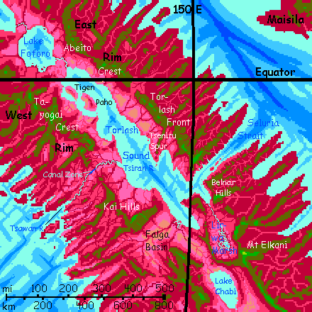
If we kept on north, as the locals do, tomorrow we might actually see the sea: an arm of Torlash Sound. But the West Rim round the sound is broken; to stay high and cool, the best flyway from here is roughly west a couple of days, then north, to skirt the Falga Basin, a lowland 300 km across. No huge gaps like crossing the Rift, but lots of short ones. A maze of high and low ground.
At the farthest west, you see a gleam of blue to the south--the Spiral Sea, at least an inlet. The only glimpse of the western sea you'll get, and it's because the Arch has sagged and narrowed so much here. We turn northeast, and soon it's gone again.
Through the Kai Hills. More than hills, really, but that's how the local name translates. A bit lower and more broken than the Rim's average, so the Kai gets no respect. What local fliers like is a nice spectacular straight cliff or mountain wall, both scenic and conveniently forcing updrafts in a line. Not this winding stuff.
Mesas and cliffs. Springs and savannas at first. Looks vaguely African. Remember, this is the heart of the Rift! It's so fertile because, despite hills fencing it off from ocean storms, it's just 5° from the equator. Those rains are heavy. Even the leftovers are substantial.
Northeast a day, fitfully climbing a kilometer higher. You reach 3.8 km high (12,500') when a straight ridge heads northwest, holding steady at 3 km (10,000').
Slowly the land gets wetter. Trees in every crevice. We're nearing the Equator again, AND, due, the gap of Seluria Strait lets storms in--nothing like the rainforests outside the Rift, but less rainshadowed.
The widest gap in a week. And at the bottom, two modest rivers--joined. The most important place on Capsica these days. The...
Intro - Touring - Strait - East Rim - Mt. Forja - Rift Crossing - West Rim - Canal
Really, it's just a dream--so far. The canal is still under construction. It has been for a century or more. Capsicans are taking their time and expanding it radually--from an ancient small-boat portage to a shallow canal for small craft only in the wet season, now enlarged enough for midsize boats to cross during the high waters and small craft year-round. In another generation or so the next planned expansion will allow the Arch Canal to carry real cargo vessels (still microscopic by our standards--light catamarans under 30 meters long, carrying mere dozens of tons--but for Capsica that's large-scale). Major shipping routes, always tortuous on Capsica since the seas are so broken up, will shorten by up to 30,000 kilometers (19,000 mi)--quite as important for Capsica as the Panama or Suez Canals combined.
It won't mean a thing for news or passenger travel, of course; in Capsica's dense air and low gravity, everyone NOT carrying tons of lumber or iron travels by air. Ten times faster!
All you can see from your godlike, miles-high perspective, as you ride the heat spiraling up from the Canal Gap, is a little stream, unusally straight, dotted with bright-colored little boats. At several ponds, little clusters where boats in transit pay the canal fee--not money, the Capsicans don't readily think in those terms--but labor! Here they get their assignment--one day's work dredging a shallow or widening a narrows somewhere that's become a chokepoint. Sailors with shovels, kids with trowels and sand buckets... But Capsicans think long.
Glide on. You can't descend, can't even afford to linger of the Canal, really--it's a long flight across the Gap, and you have to reach the cooler Tayogai Highlands before you tire. At least it's not muscle work like Seluria Strait--plenty of updrafts over that hot low stretch of valley. Lilac grass, red oaks. With that one bright little bluegreen thread strung with beads. Hardly a thing to change the world!
You can keep soaring up the West Rim all the way to Tlasi Caldera. But that's another tour.

World Dream Bank homepage - Art gallery - New stuff - Introductory sampler, best dreams, best art - On dreamwork - Books
Indexes: Subject - Author - Date - Names - Places - Art media/styles
Titles: A - B - C - D - E - F - G - H - IJ - KL - M - NO - PQ - R - Sa-Sk - Sl-Sz - T - UV - WXYZ
Email: wdreamb@yahoo.com - Catalog of art, books, CDs - Behind the Curtain: FAQs, bio, site map - Kindred sites