Capsica's homepage, map, giant ref map, geography, gazetteer . More worlds? Planetocopia!
 Capsica: Northeast Arch
by Chris Wayan, 2019
Outline only!
Capsica: Northeast Arch
by Chris Wayan, 2019
Outline only!
Introduction - Touring - Mt. Artho - North Rim - Desert Stretch - Rafa Basin - Tlasi Calderas - South Rim - Roundabout - Rift Crossing
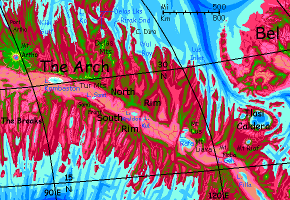
The Arch is Capsica's largest spreading zone, where new crust emerges from a rift. This valley, thousands of kilometers long, is flanked by twin ridges, typically 3-4 km high (10-13,000'); around these are a maze of lesser ridges, as the new crust meets resistance from older plates, and corrugates. It's not simple folding, either; parts of the rift spread at different speeds, and the boundaries between these conflicting conveyer belts (called fracture zones) rub and grind, pushing up lesser ridges and valleys at right angles to the Rift. The result looks like a ruined city built by giants, full of gaps in the walls and barriers blocking the ancient streets.
In short, it looks... fake. But in fact, Earth has millions of square kilometers of terrain like this! It's just nearly all hidden under miles of sea. This stretch is quite like our Mid-Atlantic Ridge--but on Capsica, with its lower sea levels, these weird landforms are exposed.
In some stretches, both on Earth and Capsica, hot spots break through this rift-zone labyrinth, building shield volcanoes; if persistent enough, a hot spot can build a whole chain of monster peaks or low but immensely broad calderas. This region has one monster shield-volcano at the west end, and at the east, a whole cluster of low but broad calderas--volcanic craters like Hawaii's Kilauea. But Tlasi Caldera proper, the widest by far, is gigantic--an oval 250 km long and nearly 200 wide (150 by 120 mi). It's Capsica's biggest; even Jupiter's volcanic moon Io can't match it--though Loki comes close.
All of the Arch is a spreading zone--its crust is new, moving a lot, subject to quakes, full of faults and fissures, volcanoes and geysers and hotsprings. Is this changeable, harsh topography hard on life? Well... not very. Since about 30% of Capsica's entire land area is corrugated rift-zones, life is used to these conditions. It's just that you won't necessarily be.
Intro - Touring - Mt. Artho - North Rim - Desert Stretch - Rafa Basin - Tlasi Calderas - South Rim - Roundabout - Rift Crossing
TOURING
If Capsicans were human, the endless fractal capes and 'fjords' walled off by high ridges would isolate each community, discourage land-travel, and encourage sea-travel. It did in Iceland and Hawaii. But Capsica has low gravity and dense air. Flight is easy, even for human-sized creatures. So the dominant life-forms will almost certainly be winged. For them, those wind-catching ridges are flyways! Those that stand across the wind create reliable updrafts stretching for days of easy travel. The ridges flanking the Rift, especially, are transcontinental freeways. From them, fracture zones offer 'onramps' and 'exits' leading to other continents. This huge, simple, consistent flyway system, way more regular than the Outer Hemisphere's spotty flyways full of gaps and sea-passages, led the Arch to dominate culturally for centuries. Communication is civilization!
Humans are weak and lack hollow bones, but with strap-on wings you can fly. Not elegantly, not strongly; I'll forbid some routes natives can handle that you can't. But you can get around. That's good, since Capsica lacks passenger transport--shipping is well developed, but it's almost exclusively cargo. Fliers get bored sailing at a tenth or twentieth the speed they can sustain under their own muscle power. Even you, riding updrafts, should sustain 50-80 kph (30-50 mph); ten times walking-speed, several times bike-speed; more like car or rail.
I'll start this tour in the northwest, at Mount Artho, and lead you east along the northern ridges bordering the Rift for 3000 km to the Tlasi Calderas. One spur will take you into that strange volcanic field, and on over the strait to the northern continent of Bel. Or you can go on southeast to the Arch Canal, Capsica's greatest civil engineering project--a series of locks that will let cargo ships cut up to 30,000 km (19,000 mi) off the torturous route from the Crunch and Inner Arch to the Outer Hemisphere.
Or, and this is the branch within the scope of our present tour, you can cross the Rift and head back west on its South Rim. Though crossing back to Mount Artho won't be easy.
Intro - Touring - Mount Artho - North Rim - Desert Stretch - Rafa Basin - Tlasi Calderas - South Rim - Roundabout - Rift Crossing
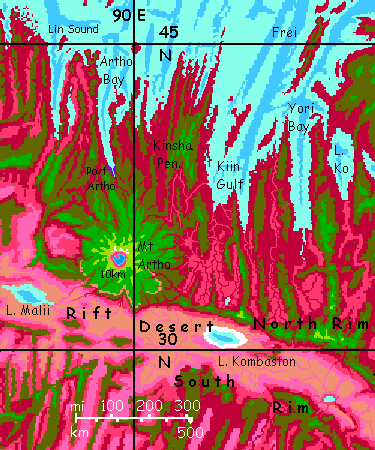
You start 6 km high (nearly 20,000') on the southeast shoulder of Mount Artho. It's cold up here, of course--only 20°C (69°F). The summit still rises 4 km above you--another 13,000'. Artho is unusual for Capsica or Earth: a solitary giant. While this height is Himalayan, a better comparison would be Mauna Kea with the Pacific stripped away from the Big Island to bare its full height. The slope is gentle--only 10° or so--but relentless, until Artho's head rears into the stratosphere.
If the hot spot under it is so vigorous, why's Artho alone? Is it recent, the first in a chain to come, or the last, have others been swallowed? Can we deduce what causes such hot spots by looking at the tail end of the line, as an examination of Hawai'i's tail reveals changes in plate motion over 100,000,000 years back?
Well... no. Artho seems to be just an outsized version of the many volcanoes dotting the Arch. Just a bigger vent than most. Though it may not be chance such a giant grew here. Artho's almost in line with the great volcanic chain forming the Notahi Peninsula. While Arthos' too distant to be the work of the same underlying hot spot, it may well be that the great weight of that chain has made this fracture zone more active than others. Cracks propagate!
Mount Artho is perhaps best thought of as like an eccentric moon or comet--not really part of the Notahi family, yet under the influence of its mass.
The Artho region is just 32-38° north, so the lowlands, wet or dry, summer or winter, are warm even by Capsican standards, and fatal to Terrans much of the year--35-45°C (95-113°F) in winter and up to 65°C (149°F) in summer. They'd be hotter yet if they weren't so humid; clouds often cover them, except in the rainshadow of the great peak, on the south and west.
But the mountain's so high that Earth tourists can survive here. Comfortably. Naked. Though Artho's taller than Kilimanjaro, this isn't Africa! If a Capsican Hemingway ever writes a short story titled "The Snows of Artho" it'll be science fiction: a dystopian fantasy of a world teetering on the brink of an Ice Age, where thin air and high gravity create snowy heights. (Absurd, really--how could life evolve on such a hostile world? But a clever premise, if you suspend disbelief.) The summit's the only place for a thousand kilometers that ever sees snow, and nearly all of it melts in summer; only a few small glaciers on the north face persist year after year.
So Artho's a climatic island--a cone of green in the sea of red. The high meadows of the outer slopes, above 5 km (16,400'), thrust up through the cloud-sea into relatively sunny air. But these heights aren't arid, as on many Terran peaks. Capsica's denser atmosphere, thinning slower in the lower gravity, means high-altitude air can hold much more moisture than Earth's; and thunderstorms reach higher, especially in global summer, when the little planet swings close to the sun. The heights are still dry enough to discourage trees--the higher peaks have quite Terran-looking meadows and fern-fells, turning gold in the winter dry season, greening again with the summer rains. Only on the southwest shoulder, downwind of the Himalayan heights, does this "alpine" savanna fray, baring the black and red lava flows beneath. A baby Tibet.
Artho's crater isn't one of the gigantic, quite Martian calderas seen on some Capsican shield volcanoes. But it's still huge--miles across, with cliffs averaging 2 km high (6600') and up to twice that in a few spots; Capsica's low gravity makes such cliffs stabler. The crater floor cups a deep indigo lake, shadowed to near-black by the mile-plus cliffs.
Anyway... I started you so high up mainly so we'd be above the cloud layer. It's quite a view. Around and above you it's green, like most of highland Capsica; plants in this Terran temperature range use something much like chlorophyll. But below, the land darkens to olive, then a dull maroon, then a deep ruby-red. What you're seeing is green plants gradually giving way to rhodofers, heat-tolerant trees using a more heat-stable molecule, rhodophyll. You'll be seeing a lot of red trees below you. Keep them that way! They're a convenient marker of land normally hot enough to kill you. Stick to the green heights--where you can.
Southeast, ruby valleys and olive-forested ridges rising occasionally to green peaks, all peering through scattered, tattered clouds.
South away, it looks different. The pale clouds, pinks and olives of distant woods all suddenly end with a green ridge. The horizon beyond looks pale with tan dust. If you suspect desert, you're right. That's the Rift.
We have no choice but to head there.
The first part is easy: just ride the slope down. It's not steep, but you still may hit 100 or even 125 kph (60-75 mph) once you get the hang of it. By sundown Artho's a massive hump behind you, and you're riding sea-winds up North Flank, the ridge bordering the Rift. You'll be following it a long time.
Intro - Touring - Mt. Artho - North Rim - Desert Stretch - Rafa Basin - Tlasi Calderas - South Rim - Roundabout - Rift Crossing
Since the walls of the Rift block storms from every direction, the inner slopes are relatively dry; more rock than forest. There are SOME trees, and even spidery waterfalls down the scenic inner cliffs. But the dusty tan floor is biologically rather sterile--dry, salty, hot (even for Capsicans, I mean). Hot enough the creeks from the heights don't get far. Certainly not the sea. The Rift, over most of its immense length, is cut off.
Day Two: east along the rim. Rising air. You just ride it all day. By dusk you've covered several hundred km.
The gigantic cliffs, the desert... they're mesmerizing. What of the tamer country to the north? There are some survivable olive ridges--mixed red and green woods--that you could follow, sweatily, all the way to Kiin Gulf. But few high, green, merely warm oases where you can get a decent night's sleep. It's a lower section of the Arch, barely 400 km (250 mi) from the Rim to the sea. Back around Mt Artho, and ahead around the Delas Lakes, it's easily twice that; on average, the crust here sags nearly a kilometer lower. And hotter. It's just not friendly for humans.
Day Three: ahead, to the right, a change in the abyss. Tan flats and rusty mesas cup a great lake, pale blue rimmed in white--like a huge blind eye. Lake Kombaston is about 200 km long and half as wide (c.125 by 60-65 mi); it varies in size seasonally (and year to year; rains down there are scant and highly variable).
No matter how hot you are, no, you can't swoop down for a swim. The desert flats below are 50°C (122°F) now, at their winter low. Even the water won't cool you enough to keep you alive; it's 35 (95°F).
Day Four: the North Rim rises to unusual heights--the Tur Range. Several craggy heads reach 4600 meters (15,000'). The summit ridge splits from the Rift rim, veering left/north a bit. Here many Capsican friends will veer off even sharper left, north along Ko Ridge. They're heading for the rich country around the Delas Lakes at the base of the Notahi Peninsula. How do I know they're not heading farther out on that huge peninsula? Well, it's winter, and northerly, and mountainous. Deadly cold for Capsicans. No one goes there now.
You'd love it.
Day Five: east along the summit ridge, it dead-ends--dropping suddenly into maroon-forested and lavender-grassed abysses between a maze of low ridges. A fracture zone! Your route jags sharply right, back to the lip of the Rift. Lower and hotter, but tolerable; and less work. The hot air rising from the rift floor makes for strong updrafts and easy flying. You camp on a peak. Green forest. Could almost be Earth until you peer over the Rim...
Intro - Touring - Mt. Artho - North Rim - Desert Stretch - Rafa Basin - Tlasi Calderas - South Rim - Roundabout - Rift Crossing
Day Six: east all morning; easy flight. Lake Kombaston is long-hidden now behind low ridges in the desert; the only water down there's a small lake glaring in the sun on the southern horizon. Lake Somi's just 35-40 km long (20-25 mi). A river hundreds of km long collects runoff from both rims, and on Earth, even in the hottest zones, a big catchbasin fed by wooded highlands would be substantial year-round; but in the heat of the Rift, most of it evaporates before it even reaches the lake. Locals can cross the Rift here, using the river for drinking and cooling off. But not you. You'd scald.
No Capsicans sail up from the desert, but quite a straggle of them soar down from the north to join you, coming from the Notahi Peninsula--vacationers sick of the numbing winter cold. It's 25°C up there! (86°F). And that's the coast; some of Notahi's volcanic peaks are actually below freezing. They ride an eastern flyway, the Delas Mountains--more broken than Ko Ridge, but higher--some peaks top 5100 meters (17,000'); high enough to be comfortable. If you want to explore the frigid, spectacular, almost Martian volcanoes of Notahi, this is the way to go.
If you keep on east with me, Day Seven's soaring is quite easy; you stick to the Rim. Around noon, a ridge snakes out into the desert--a possible bridge? But it's not even 2 km high (c.6000'), and red to the summit. You might find drinking water, but it's just too hot to camp on. Besides, it ends halfway out. The Rift looks narrow on maps, but it's wide when you're thirsty.
On east! You camp at sunset on another head with a ridge snaking out into the Rift. Beyond, to the southeast, a lake dimly gleams in the dusk...
Day Eight: skirt the silver sheet below--salty Lake Kraldon. A red-forested ridge crosses the Rift. Native fliers use it. Hot, but if you were hard-pressed to cross to the south, it's the least bad route so far. On its far eastern side, a distinct basin within the Rift; a smaller lake, peanut-shaped.
Day Nine: your first true gap; the North Rim dips into the red zone. You have to spiral as high as you can go, then glide across, losing altitude all the way. Expect more and worse ahead. Around noon, a second such gap. But at sunset you find the big one. The Rim just ends on a high head. The Rift, purple-shadowed by the miles-high crag you're perched on, extends a tongue far north. To the east, ruddy in the sunset light, far mesas hint that the Rim does resume; but that's out at the horizon. At our height that's a good 200 km distant (125 mi). Too wide for you to cross, at least unpracticed. Tomorrow you'll have to find another route.
Day Ten. Detour north to the Narrows, just 80 km (50 mi), wait till the west wall has sun-heated, cross midday, and ride the updrafts on the now-hot east wall, now in full sun, up to the forests atop....
Intro - Touring - Mt. Artho - North Rim - Desert Stretch - Rafa Basin - Tlasi Calderas - South Rim - Roundabout - Rift Crossing
Day Eleven. Skirt the biggest, healthiest riftlake on this journey: Lake Rafa. First its northern lobe, Seawind Bay; then, you ride those winds round the shoulder of volcanic Mt Lus, 5.2 km high (17,000'), south then east, until you can really see the main lake. Huge--water to the horizon.
Why's this one so big? Its catchbasin isn't larger; it's that the sea is closer, both north and south; and the breaks in the North Rim that you've been crossing mean the basin gets significant rain. Even away from the lakeshore, pink and lavender flats--healthy grassland, not the dusty tan wastes typical of the Rift. Another color you're not used to here: white. Clouds from the north break through and wander miles over the lake till at last, over the flats beyond, they heat up and vanish.
To the southeast, the east shore of the lake is a high ridge, so high it's actually green. It's one source of those clouds; sea-winds come through the gaps between the northern volcanoes, but this wall traps and forces them up. This ridge, unlike the red ones, is the real thing--a bridge high and cool enough that even you can manage it safely. The best Rift-crossing in 3000 km, for anyone wanting to explore the half of the Arch south of the Rift. I'll finish with the North Rim and the Tlasi Calderas first, then cover the south (jump ahead.)
Intro - Touring - Mt. Artho - North Rim - Desert Stretch - Rafa Basin - Tlasi Calderas - South Rim - Roundabout - Rift Crossing
Day Twelve: what seems like a detour. Northeast to a subsidiary but still high cone of Mt Lus. East along a spur to an olive-wooded north-south ridge. Another lake gleams at its foot, a long one stretching north to the horizon. Only... it's not a lake. That's the sea. Lus Inlet is the first to reach the foot of the North Rim. I should note that the south shore of the Arch is, at this point, just 500 km (300 mi) away; the second narrowest point in the Arch over its entire length (c. 20,000 km). This stretch is just low; much of the energy that elsewhere goes into ridge-building seems to be expended on volcano-building. Planets have limited scenic/tectonic budgets. Spend wisely.
South over a modest gap to high Mt Liava, 5.5 km high (18,000'). The lava flows from these volcanoes block the waters of Lake Rafa from draining to the sea; the lake is a little brackish, but quite drinkable. Nothing like the salt-rimmed riftlakes behind you.
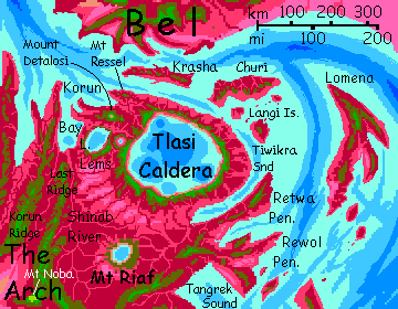
Day Thirteen: an hour's glide east along the south shoulder of Mt Liava, then a long spiral up, a gap-crossing to a lower olive ridge--this valley is so low the sea gleams just north of you: Lus Fjord again, over 500 km long; the southernmost tongue of the Arctic Sea. Spiral up again; one more gap, and you can camp on Korun Ridge--the border of the Tlasi Caldera country, the eastern terminus of our tour--and, like Mt Artho, very different from this ridge-maze you've been threading for two weeks.
Day Fourteen: north up Korun Ridge all morning. Green snaky summit-ridge, blue sky, white puffy clouds--far more rain here, near the sea--and deep red valleys on either side. Gone are the pale tan deserts, the equally pale pinks and lilacs of the savanna. The rich dark colors below--maroon, cerise, dusky plum--tell you this is farm and orchard country.
Afternoon: cross the eastern valley to Last Ridge. A long spiral, a long glide. Last Ridge too is green near the summit; a good camp. But its east face drops into alien country: the Shinab. A low, rumpled, red and lavender plain--meadows with riverine woods. This low basin stretches south and east to the horizon. Not a ridge in sight. Nowhere to go.
Your way heads northeast, to a hazy plateau, olive and green: . At least it seems to be a plateau. As you near it, and take advantage of its slopes to ride updrafts higher than the rim of the apparent plateau, and get your first glimpse of the top... it's not there. Nothing is. Cliffs drop to a huge round lake. Lake Lems is a gigantic caldera--volcanic crater. Currently dormant, but an uneasy sleeper. Carbon dioxide laced with sulfur bubbles into the lake. A whiff of it even up here. Your own sleep's not so easy.
Day Fifteen: skirt the lake, following the eastern cliffs. A smaller crater lies due east. A higher wall, beyond, is our goal: Tlasi Caldera, so large you can't see it as a unit. It's an oval 250 km long and nearly 200 wide (150 by 120 mi). Mars, Venus and Io all have calderas wider than any on Earth's, but this is outsized even for Mars or Io. Most big calderas are atop shield volcanoes that may not be steep but are still tall--Earth's Hawai'i is 10 km, Venus's Mount Ma'at over 8, Mars's Olympus 26, and on Capsica volcanic chains like Kurai and Nohaa reach 14-15 km.
Not Tlasi! The walls are just 2-3 km high (6-10,000'), and the central caldera is below sea level and flooded, as are the outer slopes. Hawai'i is largely flooded too, of course, but it rises from an abyss 6 km deep (20,000'!); Tlasi's 'abyss' is just a kilometer or two. From clifftop to its deepest blue hole, the caldera's just 4-5 vertical km. For a low-gravity world like Capsica, that's amazingly modest.
You've come a long way north, and it's winter, so the clifftops are tolerable, barely.
Like Mt Artho, the Tlasi complex is distinct enough to deserve its own short tour.
Intro - Touring - Mt. Artho - North Rim - Desert Stretch - Rafa Basin - Tlasi Calderas - South Rim - Roundabout - Rift Crossing
You ride west along a red knife-ridge capped in green, with a cloudy lavender basin on your right giving you glimpses of turquoise Lake Rafa in the distance. To the left, the clouds fail; the Rift floor is a quite Earthly desert-ochre, with maroon veins where creeks drop off your ridge into the hot zone.
No one ever accused Capsica's palette of restraint.
Long straight ridges, steady soaring. The only real difference from your eastward flight is that the abyss is on your right. No, one more: updrafts here are less reliable. Local only. The reason's simple. The North Rim is sun-heated all day; here, much of the rock face is tilted away from the sun, especially now in winter. Only heads and hanging valleys are sun-heated. It's a treacherous Chutes And Ladders game--with all the sinkholes invisible! Air looks like air. You have to watch the landforms.
It may be safer a bit to the south of the Rim. Sea-winds aren't strong--we're hundreds of km inland--but they're generally inland, that is, uphill. Ridable. And not, at 4 km up in winter, really hot--just warm. Rarely over 35°C (95°F) and 30°C is common (just 86°F).
After two or three days, though, the ridges are equally unbroken, but lower--barely 3 km high (10,000'). Still wooded, but open, with rhodophores flaming here and there amid the green. Hot, though still tolerable.
South Rim breaks suddenly--a deep canyon with a narrow, plum-red wooded floodplain snakes out to the Rift floor. The escarpment's sheer along this stretch, so the river's right below you, a winding red strip. Across the gap, the Rim slowly rises to truly green woods again, the highest coolest strip you've seen in a week--the Somi Front.
Right below the scarp of the Front lies Lake Somi. It's that little salt lake you saw long ago from the far side, on the horizon, but now it's in your face. Makes Somi seem larger, though it's just 35-40 km length (20-25 mi). From white and flamingo-pink salt flats up to Earthlike forests in a glance.
Intro - Touring - Mt. Artho - North Rim - Desert Stretch - Rafa Basin - Tlasi Calderas - South Rim - Roundabout - Rift Crossing
South Rim starts to break up--deep canyons with bloody rivers snaking in their depths. For three days, you cross a gap a day--spiraling high, planing across as you lose altitude and slide into the fringe of the death zone, regaining altitude by spiraling near sun-heated mesa rock. Hot, tiring and it slows you. The heights are mostly olive, but fortunately, scattered peaks tilt up into the green--over 4 km in places. Comfort! Green woods, creeks cool not warm.
On the third day, a white gleam on the northern horizon. The salt flats around Lake Kombaston.
From here on west, you're forced away from the South Rim by wide gaps. Indeed in The Breaks there isn't a clear South Rim. That has momentous consequences for Capsicans--over a stretch of the Rift the size of Nevada, broad gaps let summer storms slip in from the south; in places the Rift floor gets enough rain to sustain sparse savanna. The desert's pushed back for the first time since Lake Rafa, and for much the same reason. Pale pinks of dry rhodophore grass, not the earth-tones of the desert.
First day you head south. By afternoon, a north-south ridge rises into the green; but you can't camp on those comfortable heights. Timing is all when crossing gaps here; thermals don't rise all day. With the sun in the west, the lower west slopes of this ridge are hot. An escalator to the sky! You ride a mile up--over three above sea level--and cross over a deep canyon to the shady side. But it's a mere wooded mesa, just a few miles long. The west face is a sheer cliff two km high, red in the setting sun. Spiral up. A real river in the depths of this deeper, wider canyon. Crossing it uses up much of your altitude, but you make it to the olive plateau on the far side. Camp hot but alive. Despite the uncertainties of the Breaks.
Next day northwest along the rim of this plateau--rise above sun-heated east-facing cliffs, dart west across cirques and wooded promontories. Due west now. A narrows where you can see south--a great bowl of lavender grass with a small silver-blue lake in its center, glaring in the noon sun. No apparent outlet; broken mesas and ridges all round on the horizon.
Late in the day, a sudden drop-off. Not quite sheer but a three-km drop (10,000'). Below, winding red snakes in a lavender sea. West, ahead, miles off, a freestanding mesa as tall as this escarpment; and that's our goal. Climb till you're dizzy--no, it's just the relentless spiral, not oxygen shortage! Low gravity makes the dense air thin slowly; even at five, even at six km (20,000'), you get more air than on Earth. Cross the long gap. Low hills make a divide between creeks running to the sea and into the Rift. You rest atop the mesa. Tired, but I won't let you camp here. Little water, and ahead there's a final gap, not quite as wide. If we cross now, you can ride the later-afternoon thermals over the west face of the mesa; wait another hour, and we'll be trapped here a full day. Up, across to long cliffs--a far bigger ridge--and land exhausted. A mixed wood.
If these mesas were like the iconic ones in the American Southwest, you'd find no water; sandstone and limestone can be quite porous, wicking away rain. But these are basalt, holding water well; where there's rain, there are creeks--tepid, even warm, but drinkable.
A long next day, soaring around the rim of a huge C-shaped amphitheater--west, north, east. We're heading at last back to the Rim--such as it is here in the Breaks. Late in the day, wheel north again, away from the cliffs and their updrafts, over the highland forest. Camp on its north rim--great rock temples and bays, quite Grand Canyonish. But the gulfs have grass and scattered trees; just not a dry as in most of the Rift. The Breaks are inconvenient for travelers, but life is grateful for them.
Final day of your roundabout. The broadest crossing yet--due north to a sky-island sprawled on the horizon. Crags and mesas help for the first hour or two, but they sink into hummocky pink grassland. Looks less harsh than the Rift deserts, and they are to natives, but you still can't stop and rest; they'll bake you like a pizza.
You start to fear you won't have a choice; you're exhausted and only knee-high to the cliffs by the time you reach the south rim of Midway Mesa. But that's all right; it's sun-heated and the air column lofts you up past the rim. Free ride--well, no, you paid.
Midway isn't actually in the middle of the Rift; well to the south. That means the gap you'll have to span tomorrow is nearly twice with width of the one today.
Intro - Touring - Mt. Artho - North Rim - Desert Stretch - Rafa Basin - Tlasi Calderas - South Rim - Roundabout - Rift Crossing
Not an easy flight back to Mt Artho, not even from Midway Mesa, the shortest crossing. You get up pre-dawn, drink all your water, wing up, and jump into the abyss. Muscle power alone--beat steadily north-northeast for an hour before sunrise starts to warm the desert floor. You feel relief as thermals start to reach your level and you ride, half-resting, all morning. At noon, you pass a winding red-rimmed rivulet--well, since it's over two miles below, it must be no mere creek. A river robust to make it to Lake Kombaston, hundreds of km east. It's fresh water, but untouchable for you. By now it's 50° down there (122°F).
High above the dusty basin all afternoon. Low mesas, brick-red black and orange, squat and deadly in the relentless sun. Too low to be safe stops, not even for a brief rest and a drink. You wouldn't rise again.
Aching hours before the terminal cliffs of Mount Artho creep over Capsica's short horizon. More hours and actual pain in your shoulders as the sun sets and thermals die. You have to use muscle power to retain altitude.
As you near the North Rim, you start to fail, sagging below the black silhouette striped with faint waterfalls. An hour of dusky torture and you collapse in a heap of pain and dehydration on a ledge in the olive zone on the Rim. Peel wings off, stagger round this hanging valley to a little rill and drink. Warm, but welcome. At first light tomorrow you'll have to ride thermals up to the green zone before it gets too hot down here, but you're so tired you ignore dinner, planning, and the heat (35°C, 95°F). You figure even with the rocks radiating stored heat it'll cool to 30 (86°F) in the night, and dry heat, for you're inside the Rift. Sleepable. And all you care about is sleep.
But you did survive crossing the Rift--at one of its narrowest points.

World Dream Bank homepage - Art gallery - New stuff - Introductory sampler, best dreams, best art - On dreamwork - Books
Indexes: Subject - Author - Date - Names - Places - Art media/styles
Titles: A - B - C - D - E - F - G - H - IJ - KL - M - NO - PQ - R - Sa-Sk - Sl-Sz - T - UV - WXYZ
Email: wdreamb@yahoo.com - Catalog of art, books, CDs - Behind the Curtain: FAQs, bio, site map - Kindred sites