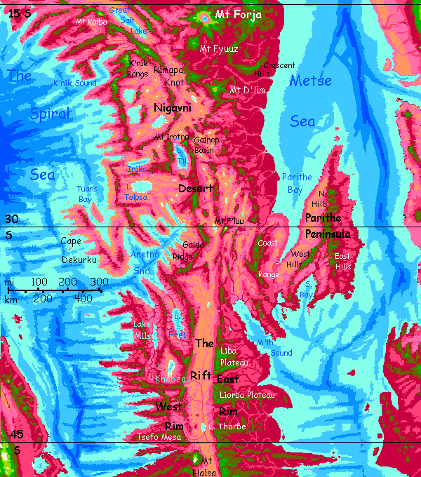
Capsica's homepage, map, giant ref map, geography, gazetteer . More worlds? Planetocopia!
 Capsica: Southeast Arch
by Chris Wayan, 2021
Outline only!
Capsica: Southeast Arch
by Chris Wayan, 2021
Outline only!
Introduction - Touring - Mt D'lim - Cape Parithe - East Rim - Rift Crossing - West Rim - the Sounds
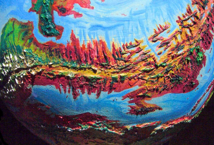
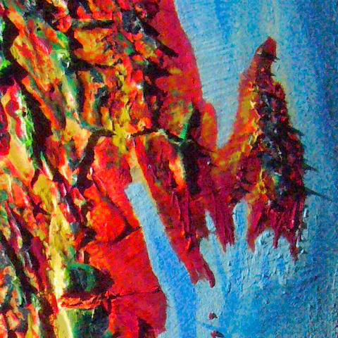
The Arch is Capsica's largest spreading zone, where new crust emerges from a rift. This valley, thousands of kilometers long, is flanked by twin ridges, typically 3-4 km high (10-13,000'); around these are a maze of lesser ridges, as the new crust meets resistance from older plates, and corrugates. It's not simple folding, either; parts of the rift spread at different speeds, and the boundaries between these conflicting conveyer belts (called fracture zones) rub and grind, pushing up lesser ridges and valleys at right angles to the Rift. The result looks like a ruined city built by giants, full of gaps in the walls and barriers blocking the ancient streets.
In short, it looks... fake. But in fact, Earth has millions of square kilometers of terrain like this! It's just nearly all hidden under miles of sea. This stretch is quite like our Mid-Atlantic Ridge--but on Capsica, with its lower sea levels, these weird landforms are exposed.
In some stretches, both on Earth and Capsica, hot spots break through this rift-zone labyrinth, building shield volcanoes; if persistent enough, a hot spot can build a whole chain of monster peaks or (if the local magma has a lower melting point) low but immensely broad calderas. This southeastern stretch has rather modest examples; the highest peaks are no taller than our largest Andean volcanoes.
All of the Arch is a spreading zone--its crust is new, moving a lot, subject to quakes, full of faults and fissures, volcanoes and geysers and hotsprings. Is this changeable, harsh topography hard on life? Well... not very. Since about 30% of Capsica's entire land area is corrugated rift-zones, life is used to these conditions. It's just that you won't necessarily be.
The north end of this stretch is one of the widest parts of the Arch; the middle is rugged desert broken by long sounds like Earth's Gulfs of Suez and Aqaba; in the south, as we near the Antarctic Sea, the rims of the rift rise to mountains bearing, in winter, actual snow.
This tour is brief. The reason's simple: not only is the region much like other stretches of the Arch, it's poorly mapped. Usually I can just magnify a slice of my world map and add details. But this stretch is cut in two, on the very edges of my world map--both right and left--and badly distorted. I've stitched a rough map together, but it's sketchy.
Intro - Touring - Mt D'lim - Cape Parithe - East Rim - Rift Crossing - West Rim - the Sounds
If Capsicans were human, the endless fractal capes and 'fjords' walled off by high ridges would isolate each community, discourage land-travel, and encourage sea-travel. It did in Norway--and Hawaii.
But Capsica has low gravity and dense air. Flight is easy, even for human-sized creatures. So the dominant life-forms will almost certainly be winged. For them, those wind-catching ridges are flyways! Those that stand across the wind create reliable updrafts stretching for days of easy travel. The ridges flanking the Rift, especially, are transcontinental freeways. From them, fracture zones offer 'onramps' and 'exits' leading to other continents.
This huge, simple, consistent flyway system, way more regular than the Outer Hemisphere's spotty flyways full of gaps and sea-passages, led the Arch to dominate culturally for centuries. Communication is civilization!
Humans are weak and heavy-boned, but in this low gravity and dense air, you can fly with strap-on wings. Not elegantly, not strongly; I'll forbid some popular native routes you can't handle. But you can get around.
That's good, since Capsica lacks passenger transport--shipping is well developed, but it's almost exclusively cargo. Fliers get bored sailing at a tenth or twentieth the speed they can sustain under their own muscle power. Even you, riding updrafts, should sustain 50-80 kph (30-50 mph); ten times walking-speed, way faster than a bike or ship; comparable to car or rail.
I'll start this tour in the north, at a place where many fliers cross the Rift--a highland called Rimapa Knot. We'll head south down the east rim of the Rift to Mt D'lim, where a side-flyway heads to the big red wedge of Cape Parithe, then straight south. Around huge Mt Sheidu, we'll cross the Rift to the west, near Nmm Strait, where readers wanting more exotic polar scenery can peel off into the Antarctic. We'll head back up the West Rim, rainforest on one side, desert on the other, around the edge of many-fingered sounds and dry valleys of the Nigavni Desert, to our starting point; you can go on north, all the way to The Canal... but that's another tour.
Intro - Touring - Mount D'lim - Cape Parithe - East Rim - Rift Crossing - West Rim - the Sounds
From Rimapa Knot southeast along olive ridges above a sea of cloud, parting to show you glimpses of maroon and purple rainforest, like the high clouds of Jupiter parting to show you the deep eye of the Great Red Spot. Hot and humid enough even up here in the mixed zone; drop much below 3000 meters (10,000') and you'll die.
Ahead is Mt D'lim, the highest volcano in the region at 6.1 km (20,000'). You camp on the shoulder near 4.6 km (15,000'), well below the symmetrical, Fuji-like summit. That smooth cone of pale green ferns tells you D'lim is young and active; little erosion yet...
That rivulet, skipping down off the heights in little musical cascades, is almost cool to your touch. Not exactly snowmelt, but a swim is actually cooling. Relief!
Southeast along another narrow ridge. No higher, but a bit less humid. To the west it drops 3000 meters, in sheer cliffs and benches, into the northern Nigavni Desert. Far off you see a pale lake shimmer. It's salt. They all are, down there.
I'm unsure what way to take you from here. For the next 800 km (500 mi) the Rift breaks up; there are no clear East and West Rims, but parallel ridges and valleys. The same amount of spreading, but arising from scattered, conflicting sources; that may be why the ridges are broken, low and narrow. Two paths lead south around Gatnep Basin.
I think we'd better take the western way. A bit longer, and through the desert, but that makes the uplands less humid; and it's slightly higher, hence cooler.
Two days later we reach Mt Irotno, 5100 meters high (16,750'). The west face is a sheer drop to Lake Til, 3.5 km below, a huge, staring green eye, deepening to an almost oceanic blue down its center. The lake's big--120 by 65 km (75 by 40 mi)--and drinkable, for salts get flushed out a modest outlet to the north, the Erga River--little more than a creek, and it dwindles in the heat until, some 310 km north (190 mi) it ends in salt ponds near Mt D'lim.
The shores are too hot for you to visit safely, even now in winter... but I have to admit it's close; it's only 40-45°C (104-113°F), so you might well survive if you kept swimming, drinking, evaporating, swimming more... The basin's high desert, at 1600 meters (a mile high), and tightly confined by high ridges; that's probably why the lake has survived, while nearby lower basins have dried entirely. I suspect there's more to it than that. This is the Rift; very deep springs may feed the lake. Even the shores are visibly different; lavender grass, not the pale pink of dry grass or tans of bare earth in Gatnep Basin. Few trees, but still--the Til Valley is a major oasis in the Nigavni.
South along the east scarp to the middle of the lake, until Irotno behind us flattens, pasted on the horizon.
Now we turn away from the lake again. Head southeast--technically we're crossing the Rift somewhere here, but who can tell? All so broken into mesas...
South along a mid-desert range--high enough to support olive forest and often broad enough to have creeks. A couple of days south. Desert valleys on both sides. This corrugated country could be central Nevada, if you carelessly left it in the oven way too long...
Mt F'luu, 5700 meters, a steep stratovolcano like Cotopaxi or El Misti, not a broad shield volcano; but that's enough to create a pleasantly cool green sky island ten miles wide where you can rest and recover. Now, in late winter, there's even snow at the summit--just a few streaks, but still! Day by day, degree by degree, you've crept out of the tropics.
Intro - Touring - Mt D'lim - Cape Parithe - East Rim - Rift Crossing - West Rim - the Sounds
East from lonely Mt F'luu. Narrow, much lower ridges.
That means hotter. It's more humid, too; you're leaving Nigavni Desert.
Coast range! That silver gleam on the eastern horizon is the sea--the first time on this trip. Parithe Bay.
South along the high coast range two days. 4-4.5 km high the first day--comfortable!--but only 3-3.5 the next--still bearable, but hot.
Cross to the Parithe Peninsula. Difficult. Worth it?
Inverted Y shape uplands. Rainforest on west coast, dry savanna and groves on the east, Mediterranean valley between the forks of the Y.
Sorry, my only orbital photo isn't great--shot near sunset, with parts of the Parithe rainforest already in dusk. But the long shadows do show you that the mountains, though snowless, are quite high, high enough for Terrans to camp on in reasonable comfort. It's just that there's nowhere to go.
Not a dead end for locals, of course--whole families in V-shape flocks head out to sea, toward the huge quasi-continent of Maisila, invisible over the horizon. There are even highlands over there you could rest on. But they're over 600 km away (nearly 400 mi).
Don't risk it.
Back west, we'll only go a day north up the Coast Range, then at the first high peak, veer left, inland, west along that spur.
Cross to narrow ridges and hop for a couple of days.
You've reached the East Rim. And there's a clear, unambiguous East Rim for you to reach.
Intro - Touring - Mt D'lim - Cape Parithe - East Rim - Rift Crossing - West Rim - the Sounds
From here on south, I'll be briefer. Two reasons:
A day more of narrow ridges, then...
Liba Plateau, a wedge of green highland up to 3.7 km (12,000') about 130 km on a side, dropping sharply into the Rift to the west.
A 50-km gap (30 mi) of steamy lowland where you're used to Rift.
Liorba Plateau, a near-twin to Liba behind you--a squarish chunk of rim 100 km across, splitting into still-high ridges to the east.
The Big Gap. 95 km (60 mi) of steamy lowland where you're used to Rift. It's probably a fracture zone.
A brackish lake is visible to the southwest--Lake Thorbe. No coincidence; the Gap lets rain in. The Rift floor is the pale pink of dry grass--savanna, not desert, rim to rim. You'd have to look several thousand kilometers to find another such gap.
At last, a stubby mesa two 2.1 km high (7000')--at this high latitude, that's up into the olive zone, hot but (barely) campable. The top's only a kilometer wide; wooded, but no water. You're too sore to go on.
In the morning, another 25 km to the next, larger mesa, an hour crossing that, then another gulf to the East Rim--and for now on, as far south as you want to go, it's continuous--partly because this stretch is higher--a mountain chain called the Dragonspines--and partly that it doesn't take as much altitude to push into the cool green zone where you can live.
Continuous rim for a day. The Rift floor, rainshadowed again, thins to desert...
To the west is a Himalayan peak, rising from the desert floor to a snow-streaked summit. This is a popular place to cross the Rift--Mt Haisa narrows it nearly by half--but let's go on. It's an easy flight south now. Green woods thinning into meadows around summits (4-5 km, no higher than peaks in the tropics or the Nigavni Desert, but we're in much higher latitudes now--it only takes 2 km to keep you alive here, and 3 is as comfortable as 4 at the start of the tour). Summery heat, but not oppressive. Cool creeks to swim in. These aren't the narrow broken ridges behind you, but a highland strip of Earthlike climate 30-50 km wide.
Two days? Three? A flattened scoop of vanilla ice cream floats on the southern horizon. It barely grows all day. Or the next.
Today you finally get near enough so it grows hour by hour. And grows. And grows...
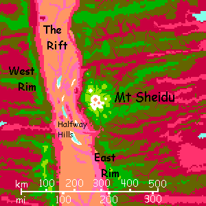
Mt Sheidu is a volcano some 7 km high (23,000'); the tallest in the Southeastern Arch, rising on the East Rim at 53-54° south. Uniquely for this stretch of the Rift, it's a shield volcano, with slopes of 15-20°, steeper than its Terran cousins--the low gravity encourages steeper slopes. Unlike most Capsican shields, Mt Sheidu lacks a Martian-style monster caldera; the summit crater is quite small, at least this century--longterm, who knows? Nor are there trailing, older, eroded volcanoes "downstream" to the east; apparently, this is a small and fairly new hotspot; so far, a modest footprint. Wait twenty million years and we'll see.
Next morning, ride the winds round the eastern shoulder of Sheidu to the south. It'll take much of the day. This isn't a mountain, it's a landscape!
The snow at the summit looks odd--cliffs and fractures show a startling pale blue-green. You get suspicious. You're right; that's ice, not just a winter snowpack melting off. The combination of high altitude and latitude is enough for true glaciers near the summit, here on the shadier southern side.
Try swimming in a creek. Brr! I bet that's not a sensation you expected on Capsica.
But we're nearing the Antarctic. Next thing you know, you'll be wearing clothes! Half the natives passing down the flyway have been wearing leggings and fuzzy hats (atop their fur and feathers) for days. After all, air temperatures have dropped to just 30-35°! They shiver in that Acapulco chill...
Mount Sheidu is your best chance to cross the Rift. Its great mass has bowed down and broken the land around it. On Earth, the seafloor around Hawai'i sags like this, though I can't think of any examples on land. Anyway, arcuate ridges and valleys with small, seasonal lakes (salt pans or mudflats most of the year) break up the Rift floor around it, punctuated by baby volcanic cones no more than two miles high, each hoping to be the next Sheidu--slipping right atop the hotspot as this new crust slides east.
Anyway, those summits, at this high latitude, are high enough to be quite survivable--merely hot. There's even a little shade; scattered trees on the heights. But they're drought-adapted, with deep taproots; surface water will be scarce.
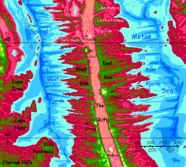
Intro - Touring - Mt D'lim - Cape Parithe - East Rim - Rift Crossing - West Rim - the Sounds
This is an easy crossing for natives, but a bit harder for a tourist like you, with your solid bones and ridiculous tendency to die in mild temperatures. I'll do my best. We have to proceed in hops. Out in that desert are scattered mesas, some high enough to be capped in open, olive woods--the Halfway Hills. These are our stepping stones. A few streams wander off the heights and snake between these ridges, but they're down in the hot zone where you can't quite go. "Water, water everywhere, and not a drop to drink."
Long arcuate mesas curve across your path, presenting you with a desert washboard. Ridge, saltpan, ridge, saltpan...
Atop the highest of these ridges, the dull olive of the scattered trees are almost shocking; the only things that aren't a dusty tan.
Though these meager sky-islands are hot, it's dry heat. The Rift gets so little rain! Walled out on both sides.
By the second dawn and third mesa out, Mt Sheidu's flanks have vanished in the heat-shimmer; the summit snows float over salt pans behind you. You're perched on a crew-cut giant's head of gray stone in the middle of a tan nowhere. Not a comfortable place. Or a safe one. Still, you'd be dead if this mesa were earlier on this tour; but at this latitude, it's only 30-35°C, not 55 (86-95°F, not 131). You can do this.
Luckily you found a box canyon with a small spring--only it's not luck. There's a huge water-glyph painted on the cliff above; this crossing's hard on the locals too. Knowledge is often better than highways.
At dawn you head due west. The mesas here are lower--no more than 1200 meters high (4000'); the sparse trees on their summits and in their cracks are all dusty red. Dry, and in your slow-death zone. No rest for you! Just sun in your eyes, a Grand Canyon panorama miles beneath you, and sore shoulders...
The West Rim's intimidating from beneath. Battlements like Sauron's Dark Tower... black basalt walls 4.5 km high (14,800'). Worse, the heat of that low-altitude oven behind you makes the air rise, pulling winds down over that lip most of the day. But your tourguide is splendidly cunning; I timed our passage so we're arriving at sunset, when the desert right below the cliffs has been shaded a few hours and has cooled, while the setting sun still warms the highlands. For an hour or two the winds still--and you can climb, sweaty and tired, up to safety.
By sunset, you're over deep green forest. Find a creek. Wash the salt off. Camp in shade. Bed early. A cold night, unnaturally so, you feel; by midnight, it drops to 25°C (77°F). Well, cold for Capsica. But then you're in high-latitude spring at 3.9 km (12,800'). What's happened is, your inner thermostat went bust.
Still, you're alive and safe on the West Rim. I call that a win.
Intro - Touring - Mt D'lim - Cape Parithe - East Rim - Rift Crossing - West Rim - the Sounds
Head south a day or two to Mt Goria--you can't miss it, it's the only other snowy peak for 1000 km. Here it's decision time. This regional tour will head back north along the West Rim. But from here, or a day farther south, you could head southwest to the sea--two days of easy gliding over green and olive hills, safe camps all over. There, at Kiib Strait, you can join the weird (almost Terran! So much green!) Antarctic tour.
The rest of us head back north. High ridges, pine-green forest and spring-green meadows. Not quite the Antarctic, but this too could almost be Earth. The deserts to the right, two miles beneath you, have rhodophores, but it's so dry there isn't much red except along streams; a faint dusting of pink grass on benches. But the deep Rift is brown basaltic rock. It's all really quite Terran.
You ride updrafts along the rim most mornings, when the sun's on the escarpment, warming it, creating updrafts. By noon, the Rift turns oven-hot (well, an exaggeration in winter here--no more than 50°C (122°F), and rising air over the flats pulls the West Rim air in; downdrafts are a hazard. You shift inland till dusk. You have to fly over chartreuse meadows and green woods. How rough! To the west, the woods have veins of plum and maroon trees in the deeper valleys--the highest fingers of a coastal rainforest.
After two days, with Mt Sheidu a white pavilion floating on the eastern horizon, you reach an odd spot. Mt Goria is still a faint, lesser pyramid behind you--just like Mt Haisa ahead! Yet the two volcanoes are 800 km apart (500 mi). Capsica's small, with sharper curvature than Earth, but both peaks are immense, and (actually more important) you're quite high up too. Oh, and one more factor you likely won't have noticed is helping you see both at once--Capsica's dense air bends light near the horizon a couple of degrees. Even Earth's thin atmosphere bends light a degree, give or take. Yep, the rising sun isn't really there yet! You get a few minutes of extra daylight, dawn and dusk. Capsica bends it 50-60% more (not 2.4 times, though that'd match the air pressure--the effect is from different layers close together, and Capsica's low gravity means they stack more loosely). Anyway, commonsense is wrong. You really can see around corners--a little, under special conditions, met spectacularly here, at this one spot... with big, high-contrast things to see 400 km away in both directions.
(By the way, you don't have to climb Everest or ride a jumbo jet to see this on Earth. Above Bend, Oregon, stands a hill with views of Mount Shasta over the border in California and Mt Rainier deep into Washington--300 miles apart! You're seeing bits of all the states between Canada and Mexico at once. Weird.)
It takes a couple of days to reach Mt Haisa. Really long views from its (very) high shoulders. From its inland flank, this Rift crossing looks short indeed. And it is--just without mesas to land on in emergency. You're creeping back out of the subpolar climate; the Rift floor will kill you now. Again.
After Mt Haisa, the West Rim thins and sags. Camp before it drops you into olive woods, or worse.
A gulf of air. You have to head hours west around it to a narrows. Still a 25-km gap (15 mi) north to...
Tsefo Mesa. Low but massive, extending over 100 km west and north, capped in mixed red and green woods. Hot, but Tsefo's sheer size lets water collect; you find rills and pools under shade. Swim to cool off. Then north along Tsefo's inner, eastern rim--a near-sheer wall over 2 km high (7000', twice El Capitan), then a rumpled gulf of desert hills.
At Tsefo's north end, a really huge gap opens to the north and west--savanna to the horizon. The Rim has just vanished--only a chain of mesas some 50 km to the northeast. That's all, in this stretch, the Rim is. Over the next day or two the gaps shrink till it's a ridge again. But you've been warned. The easy South is over.
A daylong ridge due north. To the west, a dull brown basin with a pale turquoise eye rimmed in white: shallow Lake Khabza. It has no outlet; its saltbed is over 100 km long and 55 wide (about 65 by 35 mi). Salt-dust off the flats discourage grass. It's the first lowland west of this rim that's not red, or at least pink; we're leaving the subarctic, back into desert latitudes. Last chance to visit a lowland basin! Now in early spring it's just 40-45°C (104-113°F). Go ahead. Masochists first!
A really long gap--over 80 km (50+mi). To the northwest, Lake Frei. Open woods and savanna now, neither the endless maroon forests of the south, nor the salt flats of Lake Khabza. Frei is freshwater as it drains to the sea at Anetna Sound.
All next day, follow the ridge. Fine views of the lake. Green forest plateau dropping creeks into a lavender abyss... the ruby shores, the turquoise shallows with swirls of lilac reeds, all that life. But ahead, it's hotter and drier, the ridges narrower. Frei's the last freshwater lake we'll see for weeks.
Suddenly the curves west and narrows to a knife blade. Water gets awkward; it's around, but you have to descend deep into the olive zone, almost into the red, to find creeks or even springs. Ironic as you can see Lake Frei far behind you and the sea--arms of Anetna Sound--ahead to the northwest. Water, water everywhere...
Intro - Touring - Mt D'lim - Cape Parithe - East Rim - Rift Crossing - West Rim - The Sounds
Pivot northeast. We have to skirt Anetna Sound. A fracture zone that's let the sea deep in seems like a good thing in a desert. Wrong! That salt water doesn't mean much rain; we're barely more than 30° from the equator, and winds are off the dry land, not the sea. Much like our Sea of Cortez or Red Sea, Anetna has lush life underwater, but even Capsicans find the shores harsh. The land is rugged but mostly low desert; the heights aren't cool enough for Terran tourists to survive. Or to snag much rain.
Two days northeast, up Gaida Ridge--narrow but high, up to 4.6 km (15,100'), with a thin strip of green woods and hanging valleys with small springs. Height-oases. Below, sparse red woods, then lavender savanna thinning to pink and buff deserts in the distance. Out on the western and northwestern horizon, silver gleams: fingers of Anetna Sound.
Gaida Ridge abruptly kinks northwest. At this elbow, the inland desert sports a strange mirage on the horizon: a great snowy spire. No mirage; that's Mount F'luu, from a month or two ago. Not full circle, exactly; full hairpin, full paperclip?
Northwest all next morning on a green plateau. Woods! Water! Cool heights! Well, cool as in 35°C (95°F) and heights as in 3.2 km (10,500'). Not ideal, but decent. But by afternoon it narrows and lowers. The sea gleams west and southwest now: the very head of Anetna Sound.
Solid green plateau dropping to desert or savanna; no more sea on the horizon! The Arch here broadens; to the west is 500 km (300 mi) of the Nigavni Desert called the Talpsa Basin--low desert cut off from the sea, draining to salt lakes or flats; ridges with some grass and even trees, but overall, a hard land. And a big one; the Nigavni lacks clear boundaries, but is well over 600,000 square kilometers (250,000 sq mi; nearly the size of Texas).
The plateau ends. Mesa-hopping due north. You spot higher mountains ahead, though. They look familiar. A deep basin yawns before you--with a huge lake. You can tell it's freshwater, even from up here; grass to the waterline, reeds in the shallows. Far to the north, a high sharp keel. Mount Irotno! We're back at Lake Til.
I try to avoid revisiting, to cover as much land as I can on these tours, but in this dry, broken region where water and cool heights are few, a return to Lake Til is pretty much inevitable.
From the south end of the lake, you head up the west shore an hour or two, then northwest into confusing broken highlands--peaks as high as 4 km (13,000') but gnawed deep with a maze of canyons--both red rock and red trees. Only narrow contorted spines reach up into the green zone.
Next morning, north over a gulf 40 km wide (25 mi)--a box canyon of brown scrubland with pink veins where draws collect scant seepage. It's all a mile beneath you. Ridges here are broken and just 2.5 km high (8000'); too hot to camp on, and little water anyway. Push on till you reach a higher isolated mesa capped with olive green woods. Shade and (a little, warm) water. Only an hour or two to the north end, a rock keel two miles above pink dry savanna. A salt flat gleams northeast; brackish Lake Iniks, to the west. Dark highlands 50 km north (30 mi). Rest up. We head north at dawn.
For the next week, you're heading over to the west coast, and north up it. I don't apologize for fast-forwarding. The desert holds no novelty at this point.
Up the coastal mountains. Shallow brackish lakes (or, in dry years, mudflats) break up the inland desert. With no outlet, their shores are unstable; few live near.
On the other wing, the coast is arid but livable, if you're Capsican; creeks every ten miles or so; enough for drinking water and kitchen gardens. And the fishing is excellent. The same winds blowing from land to sea, too dry for much rain, also push surface water offshore, so deep water upwells, bringing nutrients up to sunlight. Fish paradise.
At first, summits are just 3-3.4 km (10-11,000'), but after a couple of days, they rise to 4, then 5! Even on Capsica in a dry zone this is tall enough to snag a lot of rain; green forests and meadows. The K'nik Range. Ranges, really; a sprawl of ridges darting here and there. We're in a fracture zone, the geological edge of the Nigavni (and high time too). Confusing, but just head northeast.
Eventually the K'nik highlands will leads you back to the West Rim above the Great Salt Lake.
From here the Rim settles down; it's an easy (and crowded, and sociable) flyway north, all the way to the The Canal... but that's another tour.

World Dream Bank homepage - Art gallery - New stuff - Introductory sampler, best dreams, best art - On dreamwork - Books
Indexes: Subject - Author - Date - Names - Places - Art media/styles
Titles: A - B - C - D - E - F - G - H - IJ - KL - M - NO - PQ - R - Sa-Sk - Sl-Sz - T - UV - WXYZ
Email: wdreamb@yahoo.com - Catalog of art, books, CDs - Behind the Curtain: FAQs, bio, site map - Kindred sites