Capsica's homepage, map, giant ref map, geography, gazetteer . More worlds? Planetocopia!
 Capsica: The Arch: Southwest
by Chris Wayan, 2020
Under construction!
Capsica: The Arch: Southwest
by Chris Wayan, 2020
Under construction!
The Southwestern Arch: Introduction - North - Central - Derish Pen. - Uu Caldera - Nipsak Sea Basin
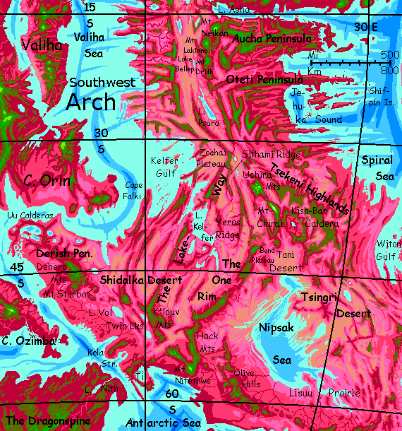
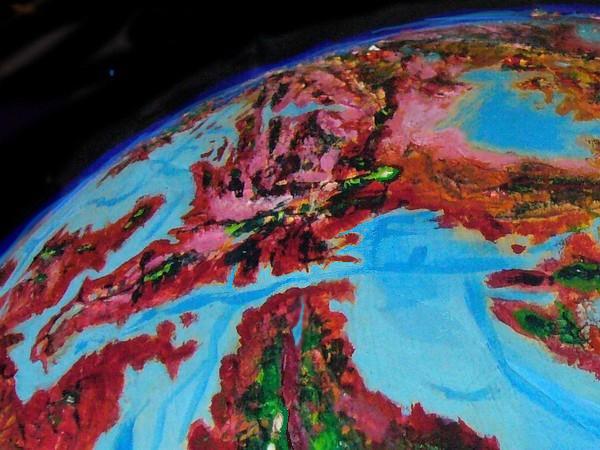
The Arch is a crustal spreading zone like Earth's mid-ocean rifts. But Capsica's shallow seas don't hide this huge structure underwater--or not much of it. The rift has two ridges flanking it, where the crust upwells; these wander, parallel, like the rails of a gigantic train track. The rift between is hot, arid--cut off from rain by the flanking ridges.
This tour covers the southwestern part of the Arch, from 15-60° south. In the north, near the equator, both coasts are rainy and fertile; farther south, the east coast is fertile but the west gets quite dry; only riverine strips and sky-islands (ridges and plateaus over 3 km high) are fertile. Past 35-40° south, the winds reverse; winter storms off the western sea nourish tall forests almost cool enough for Terrans. In the far southeast is the Nipsak Sea, a deep basin cupping a salt lake big as our Caspian; most of the basin is dry, with woods only in the south. The whole basin's fatally hot, even in winter.
Rule of thumb in the Arch: if it's green, you'll find it hot but survivable. Red? Not.
But there are nuances. This stretch of the Arch runs from the tropics to near the pole. The northern and central lowlands, wet or dry, summer or winter, are warm even by Capsican standards, and fatal to Terrans much of the year--35-45°C (95-113°F) in winter and up to 65°C (149°F) in summer. Parts would be hotter yet if they weren't so humid; clouds often cover the coasts. But inland, especially in the Rift, where it's sunny and dry, it really heats up. And yet, farther south, past 45°, and especially past 60, Terrans can survive the lowlands, at least in winter, and the mountains can be quite comfortable.
Dozens of ridges and sounds radiate from the rift at right angles; these are fracture zones, where the plate, spreading at different rates in different sections, grinds and slips. Such fractures dominate the region, defining the coastline, deciding where rain will fall (and won't), where most of the population lives, creating long updraft-corridors the locals use for flyways, and, incidentally, creating cooler highlands that Earth tourists can tolerate, largely determining our tour routes.
Intro - The Warm North - Central - Derish Pen. - Uu Caldera - the Nipsak Sea
You're perched on the East Rim. To the west, over the brink, the world just ends: the Rift, 4-5 km deep (13-16,000'); a spreading zone like that of East Africa, but more vigorous--and, in Capsica's lower gravity, less constrained. The result is harsh. The flanking rims cut off rain down there. Pale-gold crescent dunes sprawl between low gray hills dotted with rusty bushes and seamed with little arroyos, pink with dry rhodophore grasses.
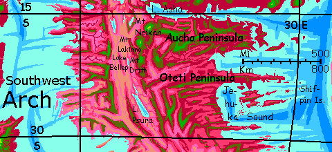
To the north dunes end and lavender grass takes over. More rain up there. It's a gap in the rimwall--long Lake Asha. It's not a river valley, but a straight, deep fracture zone that runs east 1600 km (1000 mi); freshwater Lake Asha covers just the first 400. Beyond to the east is Aucha Sound, an arm of the Spiral Sea. In the lowland heat--and an average day down there is 60°C (140°F)--evaporation's vigorous; it doesn't take broad Earthlike seas to generate rain.
Northeast across Lake Asha, too far off to see, rise the Ekurre shield volcanoes, with their alpine meadows (Himalayan heights!Miles-deep Martian calderas! Air almost as thin as Earth's! Occasional snow! Nah. I lied. Not even flurries. Here in the Capsican tropics, even peaks 9 km high (30,000') don't get snow.)
To the east, broad rich tropical Aucha Peninsula, a sort of Capsican New Guinea. You could tour it, by riding its ridges--they're 4-5 km high (13-16,500'), but Aucha's a dead end--well, large, fertile, populous islands trail off into the Spiral Sea for hundreds of kilometers, but they're too low and hot for you to visit.
First days south: two very tall volcanoes--the huge chipped tooth of Mt Neikan, a bizarre sight. Apparently Neikan blew out its side some millennia ago, for now it's a chartreuse fang 5500 meters high (18,000'), covered in pale green fernfields--too high and cool for rhodophores, though far too low (at this latitude) for snow. Very nice for Terrans just the same--an island of springlike temperatures in a sea of hot-to-fatal.
A day to the south rises Mt Lakinno, a clean, sweeping cone like Mt Fuji--though nearly a mile taller (4900m or 16,100'). On Lakinno's ample shoulders you're actually comfortable, even here in the tropics. Amazing. Appreciate it while you can. Not much comfort in the weeks ahead...
Next day, gliding south, you reach a lower cone, Mt Drith, just 3900 meters (12,800'). Though it's hot even at the summit, 35°C (95°F), that's bearable; for Drith is broad, nearly a plateau, supporting extensive (green!) woods, creeks and ponds. You camp in the shade and swim. Could be summer on Earth, not winter on Capsica at Alpine height.
Just be sure to camp on the east rim. Why? To the west, at Mt Drith's foot, Lake Bellep covers the Rift floor. Just 15 km wide but 95 long (10 by 60 mi), it's a hot, soapy mess of a lake; hot vents down its centerline spew minerals making it undrinkable. Bacteria flourish, but not much else; it's a sickly yellow. You're miles above the worst of the stink, but the western shoulders of Drith still get a sulfurous whiff.
Another day south along the east rim of the Rift. Much the same--Drithlike heights above Bellep depths. A bit lower, a bit hotter, but mitigated by your steady progress south out of the tropics. When you spot the first gleam of Lake Psura, you're near 24° south. Degrees on little Capsica are, after all, just 80 km apart; 50 miles. Even a tourist in rented wings like you can do several degrees a day. The death zone (and, more important, the misery and comfort zones) have crept down half a kilometer since you set out.
All next day, AND the next, you ride updrafts along the East Rim above Lake Psura. This isn't a stinking little mudpot like Bellep; Psura's nearly a sea. And it's fresh, for it drains north into Bellep. So (for a riftlake) Psura's lush. Lazy red snakes wind through lavender meadows to ruby marshes. Beyond, where the reeds fail, are turquoise shallows and, out at the horizon--you can't even see the far shore--indigo depths. If there are mineral vents here, they're way down, and their effluent diluted--or dumped into poor Bellep downstream.
A day south, the East Rim fails--well, sags into a wall just a mile high (1600m). Uncampable. The range swerves east, too--the whole Rift kinks here. No easy way forward; the best I can advise is to get up at dawn and head due south--across the Rift. Follow that low, red-freckled ridge--scattered trees, dry grass, bare rock. Far too low to land on, but it creates some modest updrafts. It's over 100 km (65 mi) to the far wall, and you'll have to work the whole way to maintain safe altitude.
But good things come to those who sweat. By the time you reach the West Rim, that northeast-facing cliff will have been heated for two hours by the rising winter sun to furnace heat. No, that's a good thing! Updrafts will be strong enough to lift exhausted you nearly a mile back up to the summit ridges, 3.4 km high (11,200'). Take the rest of the day off in the shade. Sit in a creek. You've earned it.
Intro - North - The Central Knot - Derish Pen. - Uu Caldera - Nipsak Sea Basin
You're on the Zochai Plateau, part of the West Rim. Zochai is a big tilde shape, 185 km long and 50 wide (115 by 30 mi). Open green woods... right up to the brink of the cliffs to the east. A creek tumbles off, green feathering into white, mostly evaporating mid-fall; the remainder rains down on that small oval lake two miles below you. A bloodshot blue eye, ringed in red. Beyond, tawny sands and orange rock outcrops, to the horizon--the Rift floor, cut off from rain.
Head south along the rim. Steady updrafts.
Just half a day later, many of the locals riding south with you peel off southwest, along a shortcut--a flyway with fine updrafts and great views of Kelfer Lagoon, a brackish body of water big as Earth's Lake Superior but hard to characterize. A lake, I guess, during the winter rains (when water flows out) and a gulf in summer (when seasonal streams slack off and evaporation increases, the flow at Kelfer Mouth reverses, pulling seawater in, as at Gibraltar year-round).
But that flyway's, the Lakeway, is rather low and hot for Terrans, uncomfortable even now in winter; plus, it crosses many miles of water at Kelfer Neck. Let's head southeast instead. A bit longer, but easier--and safer.
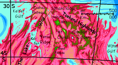
Though an hour or two later, you'll feel I've misled you. The West Rim fails too! Zochai Plateau narrows and sags into a low red ridge. But there is a way forward. Head south-southwest over a mile-deep gap onto a knifeblade crest: Sithami Ridge.
A day south along Sithami Crest. Wooded but no surface water up near the summit ridge; too narrow. You camp dry and fetch water from lower down in the night-cool, by moonlight.
East over a narrow valley (just 80 km, 50 mi; by now that feels like nothing much) to a second crest, Yeros Ridge.
East again! A harder passage over a wider plain. I'd call it the Rift floor, but here you can't say one these basins is "the" spreading zone; they all are.
Late afternoon, you reach the Uchira Mountains. This patch is broader and higher than those you've been windriding and camping on--185 km long, 110 wide (115 by 70 mi), mostly 4.2-4.8 km high (13,800-15,800'). The whole sky-island feels like a transplanted patch of Terra; green plants and few if any Capsicans--or much animal life--in sight; too cold for them in winter--as low as 25°C (77°F). After your last few weeks that feels cold even to you.
All next day a white triangle ahead beckons you. It can't be snow, of course. But it is! These daily flights really have taken you far from the tropics now. Snow is (faintly) possible--given a giant. And Mt Chirai is. Most of its long ridge is like Uchira, 4-5 km high, but in the middle, one monstrous peak thrusts up 7.6 km (25,000')! You camp on its waist and drink actual cold water--snowmelt. Chirai may seem unearthly, a Himalayan peak arbitrarily rising from nowhere, but it's not; consider Minya Gonga or Namcha Barwa, Chinese Himalayan outliers of similar height--and over a mile above every peak for hundreds of kilometers.
Southeast of Chirai, is a broad volcanic structure, Kish-Bar Caldera. Now this is unearthly--an oval 350 km long and 250 wide (220 by 150 mi); the crater wall averages 3.6 km high (nearly 12,000'), allowing no outlet for a small, pea-green, mineral-laden central lake. The rim is high enough for mixed green and red flora; cool enough for you to visit--now, at least. The outer slopes are mostly rainy and forested; the west slope is drier. Oddly, the caldera floor isn't too dry, though you'd expect it to be rainshadowed; but it's built quite high up, barely a km below the rim. Climatically it's almost a plateau. Maybe Kish-Bar is on its way to become a true shield volcano like the Ekurre Range to the north. Preferably not soon! While it's busy doing so, the whole region will be unlivable. Still, it's possible Mt Chirai isn't the outlier it seems--if you take the long view.
Some of the Capsicans on your flyway veer northeast here into the olive Witon Hills, on their way to the Lamia Peninsula in the Crunch. Don't follow. While extensive, the hills lower and spread into Witon Peninsula, a broad rolling savanna full of sunheated updrafts you could follow--but with no cool heights to camp on for hundreds of km. And it gets even worse on the far side of Witon Strait--the Ngara Desert's another 6-700 km of arid flats (over 400 mi) before you'd find a sky-island you could bear. And not just you; even the locals find this a miserable thousand kilometers. But they can rest, break it into a few days; you'd have to fly it all nonstop.
A few other locals peel off southeast from Kish-Bar--not many, for the Tsingri Desert's sparsely settled. It's a broad isthmus between the Nipsak and Rethona Seas. This route is flyable by experienced tourists; green ridges and mesas will see you through all the way to the cool green Earthlike Hithluma Plateau above the Antarctic Sea.
Southwest from Kish-Bar. Though you have to jag briefly northwest to avoid a wide gap. The Rift really is broken up here more than usual... Some hot sweaty camps as low as 2.8 km (9000'). At the start of our trip this would've killed you; but here, far south, it's merely miserable.
After days of heat, cool relief on a pleasant sky-island, Bend Plateau. Nothing special, just the usual green heights, mile-high cliffs, waterfalls, and reddish feet trailing off into pink and lilac grasslands far below.
I lied, of course. It's not ordinary. There's a reason it's called Bend. This is the end of the Arch! That largest single landform on Capsica has curved smoothly and consistently for at least 20,000 km, in a relentless, hemispheric-size pattern--but at last, you AND the Rift have left the Arch. From this kink on, the Rift stays busy, but gets less predictable.
I'm grateful. I don't know about you, but I've found it exhausting--at least a dozen tours (I've lost count!) of continent-sized segments of this great curve, all differing in detail but skeletally monotonous.
A day or two after, the lowlands to the west are unbroken savanna--no more desert! That's due to the maritime influence of the Kelfer complex--an island-dotted outer gulf, a Great Lake-size inner lagoon, and several satellite lakes. Not coincidentally, you've just hit latitude 45°. From here south to 60, the lowland desert fades out at last--light winter rains, at first just on the coast, then well-watered country even inland.
But that's macro. Touring, you have to deal with micro. Next day is bad--a slump in the wall, barely a mile high as far as you can see. You ride above it, but you can't camp or even rest down there.
Toward sunset you settle for a modest olive knoll--mixed red and green trees--no more than 2500 meters high (8000'). A wretched feverish night.
But after this, the ridges resume, and for two or three days you make good progress southwest. Easy soaring, riding the winds. The One Rim, it's called. I mentioned the Rift gets less predictable; here, there really is no facing wall, unless you count the Lakeway ridges hundreds of km west. This may be a bit like the Lake Victoria basin, splitting the East African Rift; just such tough rock the Rift couldn't crack it in two and had to go round it. On the other hand, west of the One Rim is a confusion of ridges and long valleys. Does the Rift here fray into many small faults and spreading zones?
A few days later, another kink; an Alpine ridge running due south! Halfway down this stretch, many fliers veer west. You could too--the South Polar tour, circumwindriding the Antarctic. It's a ring of lands unique on Capsica: Earthlike in temperature, with green vegetation right down to sealevel in places, rugged, highly scenic, but having months of low sun followed by months of darkness. Earth in the dinosaur eras had such polar forests; Capsica always has. Its poles have never iced over and never will.
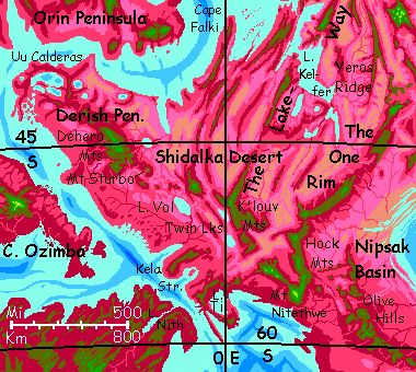
Intro - North - Central - Derish Peninsula - Uu Caldera - Nipsak Sea Basin
You're riding the winds down the Hock Range. That's a translation, but a misleading one--nothing to do with pawnshops or loans. "Hock" is the sharp forward kink in most vertebrates' hind legs at their equivalent of the ankle. It's a sensible name for this odd V-shaped range jagging away from the Rift, then back to it a few hundred km later. Locals in a hurry fly right across the gap, but I want you to follow the V down to its vertex, Mount Nitethwe. You can already see why half a day ahead: it stands out in the blue haze. Surely that white can't be snow?
It is. This huge peak can't match Chirai behind you, but Nitethwe is big--6 km high (19,700'). That's just high enough for snow in winter, here in the far south.
Not the only reason we detoured. Camping on Nitethwe's shoulder, you can see far beyond. That huge mottled lake with curving leopard-spots in white, turquoise and brown at its southern foot isn't a lake at all: that's the Antarctic Sea. Those are coral reefs. Unlike most of Capsica's seas, the water here's cool enough to sustain them!
Ride the southern slope of the coastal Hock Range for a day northwest (winds here come out of the Antarctic--same as Earth, no matter what the temperature)... toward Kifura. Next morning many locals peel off along a spur to the southwest, heading over Kela Strait to the Dragonspine region. But that's another tour!
Northwest... the K'louv Highlands (rhymes with grove) on your right, Twin Lakes to your left. Above North Twin, a flock of travelers from the northeast join you, coming off the Lakeway.
Next night, you camp on the shoulder of a massive volcano, its base at least 80 km across (50 mi!). Neither quite a Fuji-like stratovolcano or a Hawaiian shield. To the south, a suspiciously smooth arc of beach--not the sea, but Lake Vol, 145 by 95 km (85 by 60 mi). Yes, that neat ellipse is a tip-off. Vol's a caldera bigger than any on earth. But not the biggest you'll see on Cape Derish!
Next day, three hops due west along a chain of steep little volcanoes just 2-3 km high. Each a few hours, each a bit nerve-wracking--between the cones, it's low, hot, humid country with nowhere safe to rest or even land. Sleep on the third...
Due north to Mt Sturbo, 3.6 km high--and clearly once much higher. But the southwest side's been blasted out, like Mt Saint Helens; a hot lake simmers in the lopsided crater.
Dehero Highlands, the center of Derish Peninsula. Half the natives on this flyway veer southwest here, toward Cape Ozimba on the continent of Kifura (and yes, it's a true continent--just the first of many in the Outer Hemisphere where various fliers are heading.)
But first, I want to show you what lies out on the tip of Derish. It merits its own section.
Intro - North - Central - Derish Pen. - Uu Caldera - Nipsak Sea Basin
You spend a couple of easy days, gliding northwest from the peaks of Dehero along a line of volcanic hills high enough to be dark olive green around their broad summits. Gaps sink back to red forest, but there's always another blunt dome or cone at least partway into the cooler green zone.
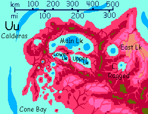
On the third day you loop around Uu Caldera--a great curving ridge with gentle slopes on the right and steep scarps on the left, dropping into a great lake. Half a day in, a massive basaltic dike separates that big lake, Upper Lake, from a bigger lake, the imaginatively named Main Lake. (From Upper to Main it's just a few meters' drop, by the way). Change to your right too--the outer slope falls away, gouged or melted out by a side-caldera, East Lake.
So Uu Caldera is plural, really. Whether on Earth, Mars, Venus or Capsica, most vulcanism on this scale occurs as part of a chain or cluster; I count at least three dozen volcanoes here on the tip of the Derish Peninsula. Finding just one solitary vent would be odd. Complexity's the norm. But two peculiarities make this complex rare:
What's going on here? Why isn't the caldera at the summit of a great shield volcano? Blame the nature of this hot spot: low or intermittent pressure, but high heat, or local chemistry causing unusually fluid magma at normal heat--though it looks like ordinary basalt. Whatever the cause, the result is, eruptions create a very big lava pool, but when pressure subsides, the land does too. Hawai'i has arcs of deeper abyss around it, where the weight of all that piled-up rock has bowed down the sea floor; clearly that's happened here on a larger scale (or maybe Capsica's lower seas just expose these arcuate trenches better).
Parallels do exist. Many vents on Jupiter's manic moon Io are broad and low, with calderas this wide (proportionately, at least--it's just a third Capsica's diameter). What's intriguing is that such holes-to-hell yawn on the same little world that has peaks rivaling the Martian giants, and quite Terran volcanic cones in other spots. Temperature and chemistry of magma vary locally, causing wildly different landforms.
So think of this region as part Hawai'i, with its huge flows but relatively fluid lava and thus low relief, and part Io, with its even more fluid magma often ebbing to create great pits as often as peaks. Or you could see it as very big mud-pots bubbling away but not building up. Yet nearby, steep cones rise. They say all politics is local. All magma, too, I guess.
A long day wheeling slowly round this gigantic ring; cliffs and lake to your left, green forest fading.
Natives use Uu's rim as a flyway; the cliffs force air up. But many peel off not long after West Lake; they aren't here for scenery, they're heading to Cape Orin on Kifura, or perhaps to Valiha just offshore. But the straits are broad and low; a grueling nonstop flight. Best stick to the rim of Uu.
On the west side, the great curve suddenly ends. Ahead, the caldera's breached; here the lakes drain. What now?
Well, the sun's setting anyway. Camp and rest.
The dawn sun glares on Main Lake below you, though it's dammed by only a low dike ahead. To the south, a chaos of cones, shattered teeth, broken rings, crater lakes, and winding lava flows: Cone Valley, slumping slowly into island-dotted Cone Sound. It's all down in the red zone, and (as I forgot to mention) the red here is truly red. Forest to open woods--no more lowland deserts or savannas! Out here on the cape, there's sea in three directions, and no high mountains to block their incoming storms. Despite the volcanic hazard, this is the most fertile part stretch on the whole tour.
For two hours you struggle across this gap; 125 km (75 mi) between green heights. A third great lake, Lower, to your left; chaos to your right.
What does this strange topography do to life? Well... not much. The whole Arch is a spreading zone, after all--its crust is new, moving a lot, subject to quakes, full of faults and fissures, and under pressure, corrugating as it spreads. Uu is just a broader vent than most. Instead of linear ridges and valleys, as in most of the Arch, concentric ridges and trenches. But it's in the same altitude-range as standard Arch landforms; the life-zones are much the same.
From here you'll have to glide back southeast to Kela Strait and the Antarctic. But that's another tour.
Intro - North - Central - Derish Pen. - Uu Caldera - Nipsak Sea Basin
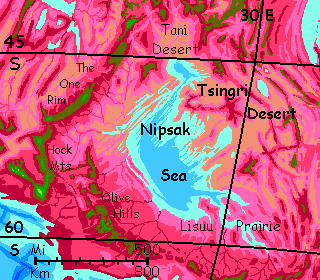
Strange to be spending just a few paragraphs on a region several times the size of France, with a sea as big as our Caspian...
When I first wrote this tour in 2020, I thought the basin was unvisitable--it's mostly hot desert or grasslands--the relatively gentle terrain is a disadvantage for you; no land high and cool enough.
Now in 2022 I'm rethinking this. The Crunch is like our Central Asia; Siberian summers are hot and winters famously cold. Capsica's denser air evens temperature swings out some, and so does the presence of the Nipsak Sea; but even if they add ten degrees to winter lows, the basin is quite high latitude, and should get as cool as 30°C (86°F); tourable after all, in winter.
Trouble is, I'm not sure I want to. It's not just flat and dry; irritating, desiccating dust off the deserts and saltflats aren't much fun. There's just too much land surrounding the Nipsak Basin, and too little sea; it hardly matters what winds blow when they're all pretty dry--wrung out by previous mountain walls, they have little left to give.
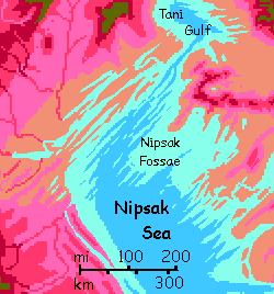
The northwestern Nipsak and the central sea floor are... odd. A washboard of low narrow ridges and troughs called fossae; neither dunes nor stream-eroded, they're a much finer-grained variant on the ridges flanking most of the Rift. Some fossae run hundreds of kilometers.
I'm not sure why the crust here's corrugated like bits of Australia or Appalachia; those are old, eroded remnants, the roots of long-ago Himalayas. But Nipsak's crust, not far from the spreading zone of the Rift, must be fairly young. Were the Nipsak Fossae perhaps laid down as seafloor features in some opposite of our Ice Age--a Steam Age, a few degrees hotter, so storms were fiercer, rains more common, and the Nipsak Sea a bit higher? After all, disconnected from the world-sea, its level is quite unstable.
But I just can't call it chance that these corrugations are perfectly parallel to the Rift. More likely an uncommon response to compression, then. As that great Russian geologist Tolstoy once wrote, "Happy tectonic plates are all alike, but each stressed-out plate crumples in its own way."
Such fossae aren't unique; the Isle of Goret and the Ri Kshen Isles have them too.
Nipsak's plains do vary--on the east and south shores especially, below the Olive Hills and on the Lisuu Steppe, some tree-dotted savannas will support decent irrigated farming (if Capsicans are herbivores) or good grazing/ranching/hunting land (if carnivores). You have a rare opportunity to tour a working Capsican farm, though of course much will be dormant in this paralyzing cold. The enzymes powering rhodophores can handle oven heat (well, 75-80°C, 167-177°F), but turn sluggish down at 35°C. (95°F)...
From the east shore, or rather the Olive Hills high above and a hundred miles off, you could head on into Capsica's heartland/crossroads, its equivalent of the Mideast, the cradle of civilization (at least if you ask the residents): the Crunch.
Well, you could if you were suicidal. Sadly, the Nipsak Basin's pattern--low, hot, salty, dusty--repeat all over the Crunch--a traffic jam of platelets and small sea-basins that just aren't quite big enough to rehumidify winds passing by; the heart of the Crunch isn't quite as arid as unbroken lands like the Sahara or Central Asia, but... these basins aren't pleasant, even for locals. For you, just fatal.
Oh, you'll be able to tour eventually--there are many highlands and I can work out safe routes eventually. But have I ventured east of Nipsak yet? (As I write this in 2022, no. Not during Covid. Just too stressful!)

World Dream Bank homepage - Art gallery - New stuff - Introductory sampler, best dreams, best art - On dreamwork - Books
Indexes: Subject - Author - Date - Names - Places - Art media/styles
Titles: A - B - C - D - E - F - G - H - IJ - KL - M - NO - PQ - R - Sa-Sk - Sl-Sz - T - UV - WXYZ
Email: wdreamb@yahoo.com - Catalog of art, books, CDs - Behind the Curtain: FAQs, bio, site map - Kindred sites