Capsica's homepage, map, giant ref map, geography, gazetteer . More worlds? Planetocopia!
 Capsica: Mount Artho
by Chris Wayan, 2015-16
Outline only! Under construction!
Capsica: Mount Artho
by Chris Wayan, 2015-16
Outline only! Under construction!
INTRODUCTION
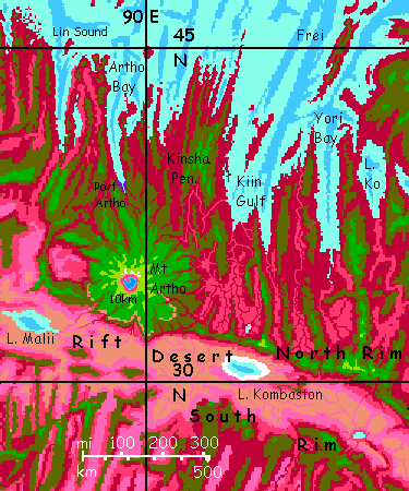
Mount Artho is a huge shield volcano rising in the rugged rift zone called the Arch. Whether on Earth, Mars or Capsica, most giants of its type are one of a chain; but Artho is solitary.
The peak is some 10 km high (33,000'), and its lava flows spread several hundred km in all directions. While this height is Himalayan, a better comparison would be Mauna Kea with the Pacific stripped away from the Big Island to bare its full height. The slope is gentle--only 10° or so--but relentless, until Artho's head rears into the stratosphere.
If the hot spot under it is so vigorous, why's Artho alone? Is it recent, the first in a chain to come, or the last, have others been swallowed? Can we deduce what causes such hot spots by looking at the tail end of the line, as an examination of Hawai'i's tail reveals changes in plate motion over 100,000,000 years back?
Well... no. Artho seems to be just an outsized version of the many volcanoes dotting the Arch. It's a spreading zone, after all--its crust is new, moving a lot, subject to quakes, full of faults and fissures, and under pressure, corrugating as it spreads. Artho is just a bigger vent than most.
Though it may not be chance such a giant grew here. Artho's almost in line with the great volcanic chain forming the Notahi Peninsula. While too distant to be the work of the same underlying hot spot, it may well be that the great weight of that chain has made this fracture zone more active than others. Cracks propagate!
Mount Artho is perhaps best thought of as like an eccentric moon or comet--not really part of the Notahi family, yet under the influence of its mass.
TOURING
Mount Artho is just 32-38° north, so the lowlands, wet or dry, summer or winter, are warm even by Capsican standards, and fatal to Terrans much of the year--35-45°C (95-113°F) in winter and up to 65°C (149°F) in summer. They'd be hotter yet if they weren't so humid; clouds often cover them, except in the rainshadow of the great peak, on the south and west.
But the mountain's shoulders are so high that Earth tourists can survive here. Comfortably. Naked. Though Artho's taller than Kilimanjaro, this isn't Africa! If a Capsican Hemingway ever writes a short story titled "The Snows of Artho" it'll be science fiction: a dystopian fantasy of a world teetering on the brink of an Ice Age, where thin air and high gravity create snowy heights. (Absurd, really--how could life evolve on such a hostile world? But a clever premise, if you suspend disbelief.) The summit's the only place for a thousand kilometers that ever sees snow, and nearly all of it melts in summer; only a few small glaciers on the north face persist year after year.
So Artho's a climatic island--a cone of green in the sea of red. The high meadows of the outer slopes, above 5 km (16,400'), thrust up through the cloud-sea into relatively sunny air. But these heights aren't arid, as on many Terran peaks. Capsica's denser atmosphere, thinning slower in the lower gravity, means high-altitude air can hold much more moisture than Earth's; and thunderstorms reach higher, especially in global summer, when the little planet swings close to the sun. The heights are still dry enough to discourage trees--the higher peaks have quite Terran-looking meadows and fern-fells, turning gold in the winter dry season, greening again with the summer rains. Only on the southwest shoulder, downwind of the Himalayan heights, does this "alpine" savanna fray, baring the black and red lava flows beneath. A baby Tibet.
Artho's crater isn't one of the gigantic, quite Martian calderas seen on some Capsican shield volcanoes. But it's still huge--miles across, with cliffs averaging 2 km high (6600') and up to twice that in a few spots; Capsica's low gravity makes such cliffs stabler. The crater floor cups a deep indigo lake, shadowed to near-black by the mile-plus cliffs.
CULTURE
The mountain generates extremely varied microclimates--wet to dry and hot to cold (by Capsica's standard of cold). That will promote ecological diversity too. But will this translate into cultural diversity? On Earth, great mountains are usually backwards, places to avoid, since we're earthbound--our modes of transport, from feet to coaches to trains to trucks, hate climbing slopes. But on Capsica, most long-distance travel's on the wing; peaks and especially ridges can generate updrafts. The Arch will certainly have two major flyways, one along each of its twin central ridges. But Mount Artho may be a navigation beacon for hundreds of kilometers all round, without being truly useful to fliers. As updrafts go, it's a point source--a very big point, but it won't send you far, unlike the lower but much more useful ridges.
My guess is, Artho will be a spiritual retreat--a place to disorient yourself, see the world from a new perspective--on the ground yet high up, simultaneously. After all, great solitary peaks around Terra acquire that function: from Kailas, Sinai, or Adam's Peak to Fuji and Shasta--all are the abode of spirits or gods and places to seek visions, despite the utterly diverse cultures at their feet.
So I suspect Capsicans will climb Artho in summer and fall. You'll fly up until you can't grab air, climb the rest of the way, and sleep shivering in the summit-rim's stratospheric cold (20°C/68°F!) and dangerously thin air (0.8 atmosphere! Like Earth a mile up), with snowpatches to gawk at (but not touch; instant frostburn). In that unCapsican, downright Earthly environment, oxygen-starved, exhausted, you may well dream life-changing visions.
Artho will be a holy place.
A DIFFERENT CULTURE
Every holy place attracting pilgrims needs... accomodations. Port Artho is far more than that--and unlike most Capsican cities, two ecological peculiarities mean you can actually visit. The city's at the head of Artho Sound, north of the peak. Cold air slips down the canyons from the glaciers on the north face--a sort of airy meta-glacier. And the city's in a narrow sound, limiting rain except perfectly aligned storms sweeping due south--and few do. It's a canyon minidesert--well, an oasis of sun at least. So for a Capsican port city, it's both cooler AND drier than you'd expect at this latitude. In late winter it's just 30°C (86°F) and not too humid. You can explore! The locals will be bundled up against that dry cold, but they can handle it--and so can you.
And because it's a port, yet downriver from a nation-sized volcano, the town exports produce from many ecozones. Remember, while Capsicans themselves don't like it cold, plant life and cold-blooded animals do well up right to the snowline--5-6 km now in winter, 8 in summer (on Earth, life fades out around 5, even at the equator). That's a lot of zones to exploit! Traders come from all over. Native tourists do too; but they may be outnumbered by spiritual pilgrims. Hard to say; lots of overlap.
All in all, Port Artho's a cosmopolitan town. One of your few opportunities to see a Capsican city safely--even in comfort. I'd go.

World Dream Bank homepage - Art gallery - New stuff - Introductory sampler, best dreams, best art - On dreamwork - Books
Indexes: Subject - Author - Date - Names - Places - Art media/styles
Titles: A - B - C - D - E - F - G - H - IJ - KL - M - NO - PQ - R - Sa-Sk - Sl-Sz - T - UV - WXYZ
Email: wdreamb@yahoo.com - Catalog of art, books, CDs - Behind the Curtain: FAQs, bio, site map - Kindred sites