Capsica's homepage, map, giant ref map, geography, gazetteer . More worlds? Planetocopia!
 Capsica: The Arch: West
by Chris Wayan, 2019
Outline only!
Capsica: The Arch: West
by Chris Wayan, 2019
Outline only!
The Western Arch: Introduction - Northwest - Southwest - East
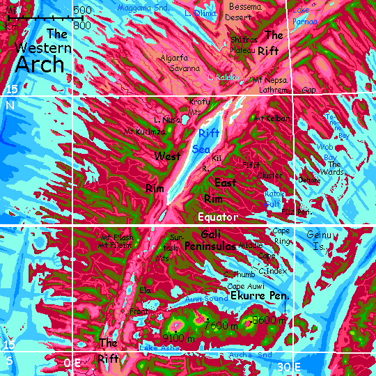
The Arch is a crustal spreading zone like Earth's mid-ocean rifts. But Capsica's shallow seas don't hide this huge structure underwater--or not much of it. The rift has two ridges flanking it, where the crust upwells; these wander, parallel, like the rails of a gigantic train track. The rift between is hot, arid--cut off from rain by the flanking ridges.
This tour covers the western curve of the Arch, from about 25° north to 15° south. The far north is drier; most winds are from the east, where there's more land; less humid. There's a weak summer monsoon, and thunderstorms in the mountains, but in general rains here are unreliable. The middle and south, being equatorial, and flanked by ocean east and west, are rainier, and mostly forested. It's hot enough for rhodophores to flourish in the lowlands; in the cooler highlands, some green plants enter the mix, but take over entirely only on high ridges and volcanic summits. The lowlands, wet or dry, summer or winter, are warm even by Capsican standards, and fatal to Terrans much of the year--35-45°C (95-113°F) in winter and up to 65°C (149°F) in summer. They'd be hotter yet if they weren't so humid; clouds often cover the coasts. But inland, where it's drier, it really heats up.
Rule of thumb in the Arch: if it's green, you'll find it hot but survivable. Red? Not.
Dozens of ridges and sounds radiate from the rift at right angles; these are fracture zones, where the plate, spreading at different rates in different sections, grinds and slips. Such fractures dominate the region, defining the coastline, deciding where rain will fall (and won't), where most of the population lives, creating long updraft-corridors the locals use for flyways, and, incidentally, creating cooler highlands that Earth tourists can bear in winter, largely determining our tour routes.
The other prominent landform you'll notice right off: huge shield volcanoes up to 14 km high (46,000'). In Capsica's low gravity, that's not shocking. Even on Earth, Mauna Kea is 10 km tall (33,000'), though much of that is hidden undersea. Most giants of this type are in chains created as a spreading plate moves over a deeper hot spot. The only such chain in the western Arch (but an impressive one) is at the south end--the Ekurre Peninsula has three shield volcanoes rivaling Hawai'i. And on drier Capsica, all that slope is exposed: the highest point on Ekurre Caldera is over 9100 meters (30,000'); though it's tropical, that's high enough for snow patches in winter. But it's unique in that. Without snow marking the highest peaks, it's hard to realize how rugged this region is; Mt Kurimza, a volcanic cone barely showing up on the map (west of the Rift Sea) is 6.1 km high (20,000')--rivaling our Mt Denali. And plenty of others are Alpine in height.
The only practical route through the region is the West Rim of the Rift. The East is, on average, just as high, but has a gap near its north end, passable by natives but not by tourists in rented wings. We'll ride the West Rim south to the borders of Ekurre, then double back north on the East Rim to the gap. It's not a total dead end, even to tourists; the flyway extends east into the Northern Arch, along the South Rim of the Rift. But that's another tour.
Western Arch: Intro - Northwest - Southwest - East
You're perched on the West Rim above Lake Parnaa. To the southeast, over the brink, the world just ends: the Rift, 4-5 km deep (13-16,000'); a spreading zone like that of East Africa, but more vigorous--and, in Capsica's lower gravity, less constrained. The result is harsh. The flanking rims cut off rain down there, and also guarantee that most streams can't reach the sea. Salt and alkali lakes, like Lake Parnaa beneath us, a garish yellow and pink swirl crusted with white around the shore. Salts build up in flats and sinks; winds spread irritant dust. Few plants can take it; the flats are bare.
The Bessema Desert behind you to the northwest seems friendly now--a maze of ridges and canyons, pink with rhodophore brush; bare tan flats on the valley floors, but with pink and even red veins where streams from the highlands snake out of rugged canyons; fertile strips with drinkable water, even if you can't visit them; too hot.
In contrast, the West Rim is so high and cool it has some rain, some trees. The desert below generates oven-heat; but that means stronger updrafts too. With care and planning we can ride those updrafts south all the way past the Equator.
For all next day, the ridge is continuous; easy, if you ignore the glare and the desiccating winds and that alkaline tang that says deep desert. Next day, near sundown, around 21° north, a short gap, just a ten-mile-wide canyon; the cliffs ahead glow in the setting sun, guaranteeing updrafts... so we make the hop now, and get lifted back to forest heights.
Next day's a good solid chunk of highland, the Shifras Plateau, 3 km up (10,000'). Mixed red and green forests. Hot--close to 35°C all day (95°F). Unlike the linear ridges of the Rim behind you, Shifras is a many-armed confusion, with box canyons gnawing into its flanks and arms flailing for miles in all directions. Ignore all that and head as close to due south as you can.
Near dusk, Shifras narrows. You reach the tip of South Arm, a great keel two miles high, and make camp by a waterfall vanishing into dim blue beneath you. To the southeast is a tall ridge with a ragged tutu of sunset-reddened clouds around its waist: Mt Nepsa. The summit, above the clouds, is a strange burning green-gold: low sun on the first purely green land you've seen so far. Nepsa is 4.6 km high (15,000'); those summit-meadows could pass for Earth. Now, in deep winter, it's no more than 20°C up there (68°F).
Next morning, you cross. It's the widest gap you've crossed so far--75 km (45 mi). Several hours--spiral up, glide across. You're reduced to flapping at times. Exhausting.
But curiously popular. Just a couple of km below you, a swarm of locals with living (not rented) wings crossing the gap--for the Nepsa Gap is the easiest Rift crossing for thousands of kilometers.
The same updrafts on Nepsa's slopes that generate those clouds lift you, easing your sore shoulders. Land and camp high on the peak. Plenty of locals camp on Nepsa, too--but way lower down where it's tolerable--not warm, just 40°C, (104°F). But to them your high perch, at 25°C (86°F) is frigid. Just right for cold, standoffish aliens from Earth. Too bad, natives! It's beautiful up here. Up near treeline, the dominant trees are a green-gold color extraordinary to see on Capsica. A species unique to the mountain.
Most locals are headed off east toward the rich lowlands around Rilwa Gulf. But that's another tour! Your way is west. Rest up all afternoon and night. The next gap is even longer--120 km (75 mi)--and fatal if you fall.
Dawn lights the far side of Mt Nepsa. You circle the peak to the sunny side, and as it warms, spiral as high as you can, above the cloud-raft around it, to 6 km, above even the peak itself. Now ride Nepsa's southeast ridge to its end. Glide east across a broad lowland. Strange, it doesn't look like rift-desert at all: lavender veined in red. This stretch gets rain courtesy of a fracture zone to the northwest: the head of long Maggama Sound is just 500 km away (300 mi), and the Maggama Valley continues, with no barriers to storms, all the way here: that's the Maggama River beneath you, issuing from that vast blue-green eye ahead: Lake Raluko. The first you've seen that drains to the sea--and thus freshwater. No salt poisons this lowland!
Lake Raluko's one of the smallest in the Rift, just 40 km across (25 mi). But that seems plenty to you, as its cool surface (just 35°C, 95°F) generates downdrafts. Skirt the lake, don't fly over it! Your goal's on the far side: Mt Enol, a steep, olive-forested cone just 2500 m high (8000'). Hot and muggy at the summit, but the best I can offer. Rest up. You're so tired you sleep despite the heat.
At dawn you round Enol's head and across a short gap see a ridge leading east and a bit south... Olive, but a bit greener at the crest; 2800-3000 meters (9-10,000'). Cross and follow it; an easy morning's ride, with thermals on its sunny southeast face. A gap in the afternoon, but nothing like the one from Nepsa to Enol...
And on the far side, you camp at the northern tip of the Krofu Mtns, higher, cooler, and, blessing of blessings, gapless. An unbroken, easy flyway, with with peaks up to 5 km (16,500'). A cool, green, safe, comfortable sliver of Earth just a few kilometers wide, but stretching a hundred south, then hundreds more southeast. Two days of bliss.
To the northwest, nothing but a sea of pink and lavender grasses rippling in the breeze--Algarfa Savanna. None of the usual lesser ranges paralleling the Rim, nor any fracture-zone ridges at right angles. The flats run all the way to the sea, 1000 km away. It's as if the tectonic energy of this section of the Rift was all used up building the heights of Krofu.
Next day, when the Krofu Range ends, a brief gap--easy after Lake Raluko. Speaking of which, there's a gold shimmer in the glare of the setting sun--Lake Nusa, on the western horizon.
But that's nothing compared to what's to the east. Far below, in that heat-shimmering netherworld, is what seems to be a sea. It is. White salt flats, then shimmering silver to the horizon--no far shore even visible. It's the Rift Sea.
The name sounds unimaginative--aren't there many such? Every tour following the Rift seems to have one or two. But The Rift Sea is the largest on Capsica--some 1200 km long and up to 200 wide (750 by 125 mi), bigger than all the Great Lakes combined; nearly as big as our Caspian Sea. I can't give you hard numbers, for it varies a bit in size seasonally (and year to year, too). Unlike the bone-dry north around Lake Parnaa, most years the Sea gets some rain--just unreliably. By volume, the Sea's fed mostly by streams falling out of the highlands.
The Rift Sea's not just the world's biggest; at over 300 meters (1000') below sea level, it's the lowest point on the Arch, with the densest air. Hot, rather humid air! Unlike our Dead Sea, the Rift Sea is huge and not drying up; at least not any more. As this stretch of Rift sank and the walls grew, cutting off rain, its lake shrank till it reached balance. We're not far from the equator, so there's a lot of rain to cut off; even the dregs can sustain a sunken sea. And Capsica's climate is more stable than Earth's--no Ice Ages--so the shore fluctuates a few meters, even dozens over time... but not hundreds.
To the west, green ridges above pink and lilac lowlands--hot savanna, with scattered trees now instead of the tawny barrens of the Rift, or the Bessema Desert behind you. We're slowly creeping into the equatorial zone. Summer monsoons here are unreliable, but can sustain trees. A few wet years and a new generation sends down taproots far enough to survive dry times.
Midway down the Rift Sea, out on the western horizon, a great pile of clouds tumble round a great peak, Mt Kurimza. A volcanic cone 6.1 km high (20,000'), the tallest you'll encounter this side of the equator. Snowless, of course! The clouds part enough for you to briefly see its cone, visibly green--so high and cool the forests on its flanks and the meadows near the summit use chlorophyll. Kurimza rises above a maze of higher ridges--an unusually active fracture zone, with a few ridges so high they're green too. More importantly for the locals, they generate strong updrafts.
So, as you stare, a cloud of tired, droopy flies ride thermals out of the northwest. No, not flies, sparrows; no, crows; buzzards; condors; pterodactyls. They're natives crossing from the continent of Kifura--this is one of the best flyways. There's an island chain that's too hot for Terrans but easy for locals...
Slowly the Rim curves due south. Sheer drops a mile or two here. Good updrafts as a result. Dance around the rim of this fire-ring...
Western Arch: Intro - Northwest - Southwest - East
At last you leave the Rift Sea behind you. But we're nearing the equator now; lavender savanna covers most of the rift floor, not desert. A chain of lesser lakes drains north into the Rift Sea. Because these have outlets, they're freshwater; maroon marshes and blood-red forests line their shores. The Rift River, like our River Jordan, is below sea level for most of its course, nearly 750 km (450 mi). You can't always see it; the floor here is more broken and complex then the drastic trench of the Rift Sea; ridges and lesser volcanic cones dot the lowlands.
All along the Rift Sea, and south of it, the West Rim highlands have brief canyon-gaps, but nothing you can't easily handle. Smooth windriding for a week!
As you cross the equator, not big ceremony. Oh, the locals down on the valley floor do duck first-timers in Lake Line. But as usual on Capsica, you can't join in. Hot water, hotter air.
At 2° two pillars of dark cloud rise ahead. Takes a full day to approach. It's safe enough. At the moment neither is really violent. The northern peak is Mount F'lash, 5.4 km high, (17,750'). Fifty km south (30 mi) is a still bigger cone, Mt Fileim, is 5.7 km high (18,700'). You camp on them. Seems odd that active volcanoes would offer a respite from the heat, but they do.
South of this, some of the lakes in the Rift look suspiciously round or oval. To the west, too far for you to see, down near the coast, another cluster of round lakes confirms the suspicion. Tropical rains are flooding old calderas. Offshore, there's a round bay between curving, craggy claws: a broken crater-rim 225 km wide (140 mi). The upwelling rock in this stretch of the Rift has, in places, an even lower melting point than the twin peaks behind you; runny lava creates broad low calderas, though the Rift floor is dotted with steeper cones too--baby F'lashes. Not all lavas are the same!
Two days later comes your chance to cross the Rift to the East Rim, by heading due south, following the Aldrak Spur, a chain--well, a scattering, really--of stratovolcanoes, steep cones 2-3 km high (7-10,000') dotting the Rift floor. Lakes fill a few. It could almost be the East African Rift near the Virunga Range--but it's a wee bit hotter down below you. Even up here, in deep winter, it's 35°C (95°F), and at least 15 degrees hotter on the floor (122°F).
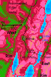
Two long grueling days--you spiral high as you can, glide southeast for hours over oven-hot foothills and snaky green-gold rivers bordered in fiery red forest, thinning to lavender savannas. Near sundown, you reach the next caldera-cluster along the Spur. One cliff-ring is tall enough to have a campable summit--a tiny Terran atoll in the Capsican sea of heat.
Next day, do it again, to a somewhat higher, cooler volcanic dome--Spur's End. No choice in the morning. Soon after dawn, you head due east over low, rippling pink savanna. Patchy updrafts at best, but by afternoon you find a rising column over a lone cone far out on the plain, forcing the winds from the east up into a little islet of cloud. Land at the summit and rest! Mt Jiferu is just 2300 meters high, 7500', the lowest point where I'll ever ask you to camp in this 5000-km tour. It's hot, hot, hot, but there's shade, and you need the rest. Beyond lies Lake Tiek--and lakes generate downdrafts! It's a long moat directly across your path, unavoidable--and fatal at this time of day.
Fear not. Your sagacious tourguide has, in a back pocket, a secret weapon: the night.
Wait till dusk. The land starts to cool. We're inland on a winter night, after all. It may get down to 45°C (113°F) down there tonight. But the lake, cooler in daylight, holds its heat at night, as water does. As the stars come out, the downdrafts fade. By the time you glide down the mountainslope and flap across the lake, you'll find mild updrafts or at worst still air. It's work, but the way's now open to the East Rim. I don't often recommend night flights for Terrans--landings are hard. Well, easy. Intentional landings are hard, and soft intentional landings harder still. Do your best. You're crossing the Rift; no course is easy.
In the morning, assuming you didn't knock your brains out on the rocks of that hanging valley, from your perch two miles up you look back in lurid dawnlight over the Rift floor. Pale blue lakes, screaming pink hills, deeper magenta ridges. Far off across the lake you see a faint olive cone capped in puffy salmon clouds--Mt Jiferu. You've made it to the East Rim.
From here, it's either back north along the Rift, completing this tour, or east onto the Ekurre Peninsula with its near-Martian volcanoes.
Western Arch: Intro - Northwest - Southwest - East and North Again
You're on the East Rim, looking down a cliff-cove at dawn. Dim blues and purple shadows. Take your time at breakfast; you have to wait for the sun to reach down in those hanging valleys so the updrafts really get cooking. Now you can launch off the cliff, with over a mile of abyss beneath you, and soar. Another day on the Rift!
And another, and another. This first third of our long leg back north is a fairly straight flight along the East Rim, logistically simpler than the previous legs of the tour. The Rim here is a steady massive scarp 640 km long (400 mi), 3-4 km high (10-13,000')--the Ela Front. Equatorial heat, even up here, but amazing scenery. It's almost like hang-gliding over Mariner Canyon on Mars. Slopes in places, cliffs in others; always that immense drop to the rift floor--the lower gravity allows a deeper gash and higher rims than, say, our East African Rift. Lake Ela below you has azure depths--it's over a kilometer deep in spots--but this is a volcanically active stretch of rift, so green and gold shallows mark tufa-towers, where hotsprings have build fragile, everchanging castles up to the lake surface. Most Capsican lakes have what we'd call thermophilic life, used to bathtub-hot conditions; but around such vents the water may be over Earth's boiling point--not Capsica's of course. In the dense air of sea level, water won't boil below 124°C/254°F, and Lake Ela lies below sea level, so the boiling point's higher still.
At 7° south, a gap. Low twin cones on the horizon--volcanoes just 2500 meters high (8000'), barely darkening from red to olive at the peaks. Take your pick. Either will be a hot, uncomfortable camp. But the best around. At least, in this humid zone, there's shade and water even near the summit. Still, you sleep badly. Feverish.
Next day, a similar gap. But relief's ahead on the northern horizon--a high green stretch, the Surtash Range, up to 5 km (16,500'). To the east, humid lowlands--ruby canyons swathed in cloud, darkening to purplish and olive forests on the ridges, which run all the way to the eastern sea--and then into it, forming the Gali Peninsulas, a hand with fingers 3-500 km long. Cape Thumb, Cape Pointer, Cape Index, Cape Ring (no Pinkie--Capsican hands don't have one). Wealthy farm valleys with sheltered ports, all unendurable for you. Stick to the Rim.
An easy day north. Green land that could almost be Earth--except for the great dropoff to the west into an alien abyss.
Next day, at 2° south, Surtash Ridge starts to sag and break up. Here a fracture zone has managed to fracture the Rim itself. You have to swing northeast, away from the Rift. Olive ridges barely 3 km high (10,000'), though bearable now in late orbital winter, a mere 35° (95°). You cross deep red canyons, but the gaps are never wide.
After three days, the highest ridges are to the northwest; back to the Rim. Ride the front above the narrow green summit-strip 4.3 km high (14,000'). Two easy days northeast. Fingers of this highland stretch east; even the valleys are olive, 2-3 km high (7-10,000'). To the northwest over the Rim is a savanna valley; the far side is a red-forested mile-high ridge, a splinter of the East Rim, hiding the shore of the Rift Sea. The maroon-wooded stream down the bottom of this long valley, the Kii River, is a main feeder of the Sea.
You have to detour around a side-valley some 50 km across (30 mi). Slows you, but not hard--high ridges on three sides. From the eastern end, you spot two steep cones on the horizon--one east, one south. They're two outliers of the Fifif Cluster, a field of stratovolcanoes just inland of Ratok Gulf and the Fiiz Peninsula. At least a dozen major cones rise 2.5-4 km (8-13,000') above a confusion of lower hills and cones. Tropical warmth, generous rains and volcanic soil make the Fifif a rich farm region, densely populated; sheltered Port Ratok at its east end does busy trade. The easternmost cone of the Fifik group is right above Port Ratok; one of the few places you can look safely down on the eastern sea--but you can't tour the port or swim in the sea, even now in late winter. Just too close to the equator; it's 50° down there (122°F)! Let's stick to the Rim.
A day or two of twisting ridges around the head of Kii Valley. Here half the natives riding the Rim peel off onto a writhing northwestern spur, one of very few to cross the Rift entirely--an excellent flyway for locals. Not for you--the ridge is tall enough to generate updrafts, but never reaches out of the red zone, intolerably hot for Terrans.
Instead you want to head for a place the natives avoid. North-northeast a full day. You can't miss it--Mt Kelban looms on the northern horizon, sometimes trailing cloud-scarves, but more often bare and pale green. We're creeping back far enough out of the monsoon zone so Kelban's shoulders above the clouds are treeless--but still grassy, unlike the high-altitude barrens of many of Earth's high tropical peaks. Capsica's irregular orbit creates seasons even up here--summer thunderstorms and thin winter rains.
For you, those shoulders, still well below the summit at 5.9 km (19,400') are a pleasant oasis--30°C (86°F), with creeks that for once aren't hot as bathwater--good swimming--and splendid views 200 km in every direction. The only ominous note is that that the view's so unobstructed north of you. Lilac and pink hills to the horizon--much of it savanna not desert, quite fertile for the Rift. The reason's simple: no Rim to block storms from the eastern sea. I mentioned at the very start that the East Rim is a harder flyway because of a great gap. This is it--the Lathrem Gap.
Skirting the Lathrem is feasible, but tedious--you have to hop between ridges and mesas for several hundred kilometers northeast, then east to the hills above the head of long Tonono Bay, then northwest again for days to the main Rim near Lake Parnaa. It's just an 800 km journey as the native flies, but 2000 as the tourist timidly glides (500 miles grown to 1250). Sorry! Just no heights in the Lathrem cool enough to camp on. Savanna and desert all the way.
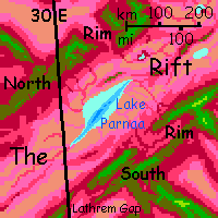
At last, in your roundabout tourist way, you rejoin the Rift near Lake Parnaa. It's leaf-shaped, and the 'stem' and central vein is a trench some 250 km long (150 mi), with mineral vents and hot springs. The wide lobes of the 'leaf' are quite shallow. There's no outlet; so it's brackish and seasonally varies from 120 to 145 km wide (75-90 mi).
From above Lake Parnaa you can't cross safely to our starting point either--the Rift floor is wide, dry, hot and unbroken by thermal oases. But you could go on east along the Arch, following what's now called the South Rim. The Arch does arch after all--its great curve leads you away from the equatorial heat. Not that it's cool. But a bit less oppressive...
At least you can go there if I've written that tour. But have I yet?

World Dream Bank homepage - Art gallery - New stuff - Introductory sampler, best dreams, best art - On dreamwork - Books
Indexes: Subject - Author - Date - Names - Places - Art media/styles
Titles: A - B - C - D - E - F - G - H - IJ - KL - M - NO - PQ - R - Sa-Sk - Sl-Sz - T - UV - WXYZ
Email: wdreamb@yahoo.com - Catalog of art, books, CDs - Behind the Curtain: FAQs, bio, site map - Kindred sites