Capsica's homepage, map, giant ref map, geography, gazetteer . More worlds? Planetocopia!
 Capsica: Yaku and Az
by Chris Wayan, 2010-2011
This one's for you readers, who pestered me until I had to build it
Capsica: Yaku and Az
by Chris Wayan, 2010-2011
This one's for you readers, who pestered me until I had to build it
INTRODUCTION
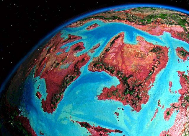
If these structures were on Earth, they wouldn't be named Yaku and Az; they wouldn't be named anything. They'd be an undistinguished patch of sea floor--maybe a few islets in the far south. Only because the seas here on Capsica are so shallow do these two rumpled platelets rise above water at all.
Not that it does them much good. The twin continents have a twin curse: stuck downwind from the vast uplands of central Chai, they get dry winds and little rain; and they lack uplands themselves to squeeze rain from the stingy air. Their low mountains, rarely higher than 3 km (10,000') and mostly half that, barely reach into the chlorophyll zone. Maybe a triple curse: they're in a low, dry latitude prone to deserts anyway. It's hot even for Capsica. Not quite the world record, but summer highs from 75-80°C are common and 90 has been recorded (171-177°F, up to 194°F).
Most Capsican lowlands are red or purple, covered by rhodophyll-bearing plants. Not these! Dusty pink to brown--sere grasslands and bare desert. The far south does get a reliable summer monsoon, and the higher hills get modest winter showers, but the vast heartland suffers long, irregular droughts. Storms are as likely to bring dust as rain.
TOURING
Well... this is a problem. The Twins, unlike all their neighbors, simply lack highlands cool enough for Earth tourists to survive long. In orbital winter, the arc of southern mountains is livable. It's possible to skirt the Twins' southern edge following the Timun Mountains and Melao Hills.
Beyond that? Well-acclimatized athletes might detour most of the way out the Luao Peninsula, though the hills are only a few km high and very hot; or even leave the shores of the Iri Sea and head partway up the east coast of Az, along the southern Karsha Hills, and cross the straits to the higher, cooler mountains on Kifura, following those north to Chai and other lands north and east. You could do it, though I wouldn't want to. You'd better fly only at dawn and dusk, or risk night flights, when it drops to a mere 30-40°C (86-104°F). The days get up to 45-50°C (110-122°F); survivable if you siesta in cave-shelters til sunset, I guess.
But crossing the heart of the region, let alone touring it in any comprehensive way, looks impossible to me for human tourists without high technology.
Of course, as Clarke pointed out, "A sufficiently advanced system of bribery is indistinguishable from technology." Lack refrigerated vehicles? Just pay a few dozen of the locals, who almost certainly fly (low gravity, high air pressure), to rig up a fishnet with long hauling-lines and carry you, wrapped in wet sheets, across the deserts at night. Why not? They do this with valuable express airfreight--seafood, for example. If you're solvent, and polite, they probably won't drop you.
But is it worth the discomfort and risk to see a moonlit hazy plain miles below you? That's about all a human can experience of these lowlands. In summer, even the rivers, such as they are, run hot enough to scald.
AZ
This continent, shaped a bit like a wineglass with a fat bent stem (the Luao Peninsula), is dominated by the broad Wasei Valley. The many-armed Wasei River collects much of the runoff from the green Timun Highlands inside the monsoon zone, and funnels it north through savanna, then grassland, then desert to the sea. Az, while very hot, has far less true desert than Yaku, its big sister to the west. The tropical southern "stem" is much like our South India, an Edenic forest full of fruit (well, Edenic to the locals! Satan's Sauna for you). But the Timun Range is the tallest on the twin continents; with peaks up to 4500 m (14,750'), their heights are not olive, not mixed, but genuinely green--high and cool enough to be almost comfortable.
35-40°C (95-104°F) is comfortable, right?
The east shore also gets enough rain; there's a longer dry season, but the locals won't mind, shaded under lush trees. It'll rarely rise above 60-65°C (140-149°F) even in summer. Even evaporative cooling schemes won't help human tourists here; summers aren't just oven-hot but humid. Not baked to death--steamed!
But only on the coast. The Karsha Hills, though too low to rise into air cool enough to really relieve Earthlings, are still high enough to block most storms from reaching far inland. As you go north the Wasei tributaries dwindle until the savanna bleaches pale lilac and fades to tan sand and orange rock: the Welda Desert, one of Capsica's hottest.
The Wasei's floodplain will be the only (large) oasis in this barren heartland. It does differ from our Nile in one way: many branches descend from the hills all round the little continent. Instead of our Nile's reliable yearly flood, levels will depend on the rather irregular rains in the east, south and west. Still, the river rarely fails; these three feeder-regions are very different, and drought or flooding in all three simultaneously is not common. So I'd look to the Wasei as having real potential for a literate, high civilization--if one that has perhaps less confidence in the gods than in its weather bureau. Since Capsicans probably fly (given the high air pressure and low gravity) travelers and traders may be more welcome for their informational imports than material ones; weather news traveling on the wing at 60-100 kph (40-60 mph) could cross all Az in a few days, certainly outrunning the weather itself--and any floods. Fliers don't really need weathersats.
The west coast has one visitable region: Cape Dalinga. While drier than the monsoon forests southeast of it, this last gasp of tropicality is wooded and well-watered by the scant standards of Az; and, more important for Terran tourists, the Dalinga Mountains are a broad cluster of volcanic cones rising from 3 to 4.4 km (10-14,450')--out of the red zone into the green. Their high shoulders snag rains, and feel quite Amazonian (if a bit hotter); the summits, above most of the clouds, resemble African savanna--hot and semi-arid, fed only by thunderstorms--but those aren't that rare. Capsica has dense air and low gravity; cloudlayers pile higher than on Earth. These aren't the freeze-dried barrens found on Terran equatorial peaks truly above the clouds.
So the Dalingas are livable. But I don't recommend heading further north, along the narrow ridges of the Rezh Hills. This coastal range gradually drops to just 2 km (6600') above very hot arid plains, pale pink from dry grass. In late winter the heat might be just barely tolerable, letting you win through to the continent of Chai to the north; but you wouldn't find water on the ridgetops, only lower down where the heat will kill you. In summer the hills get rain from thunderstorms, but then the heat would be fatal even on the heights.
Instead, I advise travelers to head west over the narrow Krokpa Strait, to...
YAKU
Though nearly twice as big as its eastern sister, Yaku has less biomass. The south is fertile, like southern Az: the east shore of the Mashmelao Peninsula, and the Melao Hills northeast of that, are more sauna forests, ruby-red in the lowlands, plum and olive and even green higher up. The Mashmelaos are as good a base camp as you'll find in Yaku, topping out over 3 km high (10,000') and rarely get much hotter than 40°C (104°F).
The southwest coast around the Salsu Gulf has briefer but fairly reliable rains--open monsoon forest, dusty rose. Quite fertile though too hot to visit.
Inland and to the north, the Ofida River's many branches look like bloody arteries on a broad plain of meadows and groves like a far hotter Senegal. Not just too hot for Terrans--too hot for most Capsicans! The monsoon rains cause annual floods; then comes the more or less annual drought. But still, Ofida's full of life.
Northern Yaku, however, is mostly dry savanna and desert.
The central plains are monsoon country even harsher than the Ofida Plain--desert most of the year, but flooding in the brief, fierce rainy season. Muddy marshes and claypans turn to shallow lakes; year-round lakes may double in area almost overnight. Lake Nubi may reach 250 km long and 135 wide (150 by 80 mi) while many-armed Ngu in a good year sprawls 500 km long and 125 wide (300 by 75 mi). The third great lake, well to the west, is narrow Lake Charr. Nestled at the foot of the Charr Mountains and a low parallel ridge to the east, Lake Charr can't widen more than a kilometer in most places, but it lengthens from about 320 km (200 mi) to over 400 (250 mi).
All these lakes of central Yaku do drain to the sea (if not much during the dry season); so although they're muddy and crawling with ephemeral microbeasties you don't want to drink, still, they're fresh water.
The northwest is not so lucky. The Manifol Hills are oriented so most of their meager runoff collects in a large internal basin. At its low point, shallow Lake Kalai evaporates quickly in the fierce sun, concentrating salts. Unlike the rich mud left by the Wasei's floods in Az, or the reedy shores of Ngu and Charr, around Kalai, rainy-season flooding salts the surrounding flats, and dry-season dust storms poison the whole basin with salt and alkali.
Only the Charr Mts and the highest of the Manifol Hills, above the dust, are at all fertile. The Manifols and the northern Charrs are more a straggle of whalebacks in the northern desert, but the southern Charrs are one long ridge--maybe like the ridges along fracture-zones in Earth's deep seas. It's as impressive a wall as the Panamint Range looming over Death Valley, and Charr's heights, like the Panamints, squeeze rain from the desert air. One peak reaches 3300 m (10,800'), as high as the Mashmelaos. High enough for Terrans to survive (if not thrive) in winter. Getting there alive may be a problem, though!
The northeast lacks that fourth curse at least. It's blessed with an irregular shoreline--gulfs like Nomak, Tempa, Oi and Ngu moderate the heat and bring at least a little rain. Streams may be few and seasonal but at least they drain to the sea--some arm of it. So while the coasts are hot dry savanna, and desert behind the coastal mountains, it's sandy and dusty but not salty or alkaline. The inland basins are true desert, and with rather unreliable oases for the most part--nothing like the great fertile strip of the Wasei. But honest desert, not poisoned land!
Why is this coast desert at all, you ask? True, east-coast deserts are a rarity on Earth. Consider the few exceptions: the Red Sea shores of Egypt, Sudan and Eritrea; the Persian Gulf and Oman; perhaps northern Somalia. All resemble northern Yaku: seas not oceans lie upwind; high mountains rise on those upwind shores; and latitudes are low, between the temperate and tropical rainbelts. Yaku's not as bad as, say, the Persian Gulf emirates or the Red Sea coast; the Uboha Sea is wider, and Capsica's heat evaporates water faster, rehumidifying the dry air. So we find semiarid coasts fading quickly to desert inland.
Look for modest towns at rivermouths along this coast, mixing trade, agriculture and fishing. These gulfs will be rich fishing grounds, as the dust fertilizes reefs in the shallow waters. There's even decent timber in the hills on Cape Tempa, the Deppit Peninsula, and Cape Krokpa; towns here won't all be mere mud-brick hovels.
Maybe a Babylon or two.
Oh, and maybe one Los Angeles, or at least a Catalina. Northern Nomak Bay and especially Cape Oyu, at the very tip of Yaku, are on the border between the dry zone and a more Mediterranean climate--plus, Oyu gets storm fronts off two seas, not one. Like Southern California, they get a little winter rain as well as summer thundershowers. Streams are still often seasonal but trees line the watercourses and dot the hills. Fatally hot to Terrans, of course, but pleasant country with a mild climate, if you're a native; a real oasis. And a hint of the bigger, richer continent to the north: Chai.

World Dream Bank homepage - Art gallery - New stuff - Introductory sampler, best dreams, best art - On dreamwork - Books
Indexes: Subject - Author - Date - Names - Places - Art media/styles
Titles: A - B - C - D - E - F - G - H - IJ - KL - M - NO - PQ - R - Sa-Sk - Sl-Sz - T - UV - WXYZ
Email: wdreamb@yahoo.com - Catalog of art, books, CDs - Behind the Curtain: FAQs, bio, site map - Kindred sites