Capsica's homepage, map, giant ref map, geography, gazetteer . More worlds? Planetocopia!
 Capsica: Eastern Bel
by Chris Wayan, 2016
This one's for you readers, who pestered me until I had to build it
Capsica: Eastern Bel
by Chris Wayan, 2016
This one's for you readers, who pestered me until I had to build it
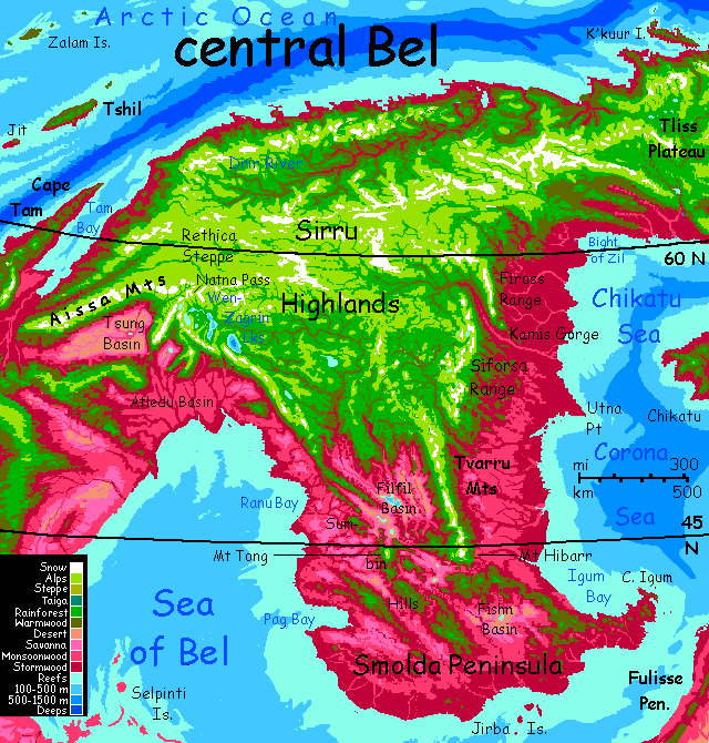
Introduction - northern Zil Peninsula - Sirru Highlands - Smolda Pen. - eastern Sirru - southern Zil -
Bel is about as big as South America. It's the second largest landmass on Capsica, though not by much--Chai and Kifura are nearly as large. Bel's the coldest continent on average; much of it's subarctic, and Eastern and central Bel have extensive highlands, further cooling the climate. That's good for Terran tourists; you can travel freely all over the north, and in winter you can even explore much of the south.
Unlike Chai and Kifura, several separate tours will be required to explore Bel fully; it's a spidery, amoeboid place, and its lobes are very different. Like Siberia, Bel as a whole spans nearly half the planet! It's hard even to photograph from space; bits trail off into night, or over the horizon, or are lost in sun-glare.
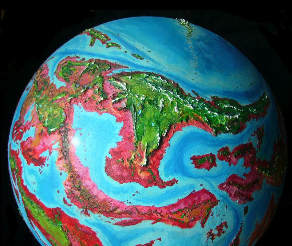
Bel's really not a continent at all in any geological sense; not a slab of lighter rock, nor a unified plate. It's a hodgepodge that just happens (as much of Capsica doesn't) to be cut off by shallow seas. If Capsica were Earth, blessed (or cursed) with deep oceans, Bel's central and eastern uplands would be a smallish continent; the west, an Indonesian maze of island arcs; the southwest, a Borneo with satellites; southeast Bel, a mere Hawai'i.
This tour explores the cooler east and north, the highlands of central Bel, and Smolda Peninsula south of them. To the southwest is the equally long but much lower, hotter and drier Fulisse Peninsula. The tours of hot, arid Southwest Bel and the ridge-maze of Northwest Bel are skeletal--they lie on the very edge of the world map, and building less-distorted regional maps is slow work. Even the maps for this tour weren't easy, and are less accurate than most regions. Still, this will orient you:
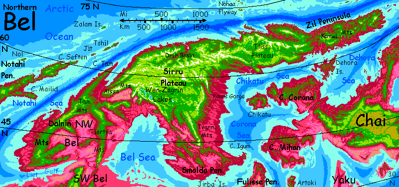
Introduction - Northern Zil Peninsula - Sirru Highlands - Smolda Pen. - eastern Sirru - southern Zil -
Northeast Bel is a long, green, mountainous finger. Veterans of other tours will be suspicious of that word "green", since most plants on Capsica are rhodophores, ranging from lavender grasses to deep plum-red trees. And you will find some rhodophores along the coast, especially in the south. But the highlands truly are green; a reliable indicator of cold, cold so severe rhodophores can't compete. Much of the interior experiences brief freezes on winter nights, though typical daytime temperatures are 15-20°C (59-68°F); higher mountains (and some are very high) acquire snow. Such snowpacks are the most extensive on Capsica outside the two Antarctic highlands, Hithluma and The Dragonspine Range. There are even glaciers on a few high peaks.
What's the climate like? The coasts are mild (for Capsica) and rainy. On the north coast, summers are Caribbean, but the midwinter sun is low, stays just under the horizon for a few weeks; a few years see frost at sea level. It's rare though. Rhodophores still dominate, though head inland or uphill and they thin out fast.
I've set most Capsican tours in winter, but Bel's big and cool; we can start in late summer or early fall. Anywhere else, the mere word "summer" would mean you need to strip down. Not here. Clothes are just fine. You may even need a coat later on. (Don't faint in shock.) Still, keep your pack light; we're flying. With Capsica's low gravity and high air pressure, any fit Terran can fly here, in strap-on wings. And of course we won't be flying much, just riding updrafts; while northern Bel isn't as hot as other Capsican regions, heat isn't the only source of rising air! This is rugged country facing steady winds--the equivalent of Earth's tradewinds. The cool high-pressure zone at the pole forces air south; Coriolis forces bend them west. This gale slams into the north coast of Zil Peninsula; the mountains force the wind up into a linear plume ridable for 2-3000 km. We'll follow the wind west to the base of Zil Peninsula. In many tours we must stay inland, on ridgetops; here, that's not essential. We can shuttle from snowy peaks to warm beaches. Highlands, lowlands, all accessible, scenic... comfortable. Shockingly Terran. And at any other time of year, you couldn't swim--too cold.
Culturally, this green country is lonely, backward--Siberian. Capsicans just don't settle in great numbers here. Why? Half climate, but half geography. Eastern Zil Peninsula isn't just cold for Capsicans, it's off the flyway--no straits or island chains lead to other continents.

After a week on the wing, the coastal hills lower a bit; narrow plum ribbons meander inland, between somber green hills. This stretch of the central mountains is no lower, they've just massed together into one huge complex, the Kamwi Knot. Even now at the end of snowmelt, a vast white fist threatens on the southern horizon. Those are glaciers up there, above 7-8 km (23-26,000'). Mt Kamwi at the center of the knot rises to 10 km (nearly 33,000'); one of the continent's highest peaks. Remember Capsica's lower gravity; Himalayan ranges are more common here.
Two days later the mountains near the coast again, and the shore veers a bit north. We seem to be following a curved mountain-arm into the sea--the Boreh Range. Not much choice but to follow this arc to the tip--it's too high to cross. Not too cold; the air's too thin up there. Oh, you can breathe--even at 6 km (near 20,000') it's still 1.2 atmospheres. But you can't get enough lift to climb.
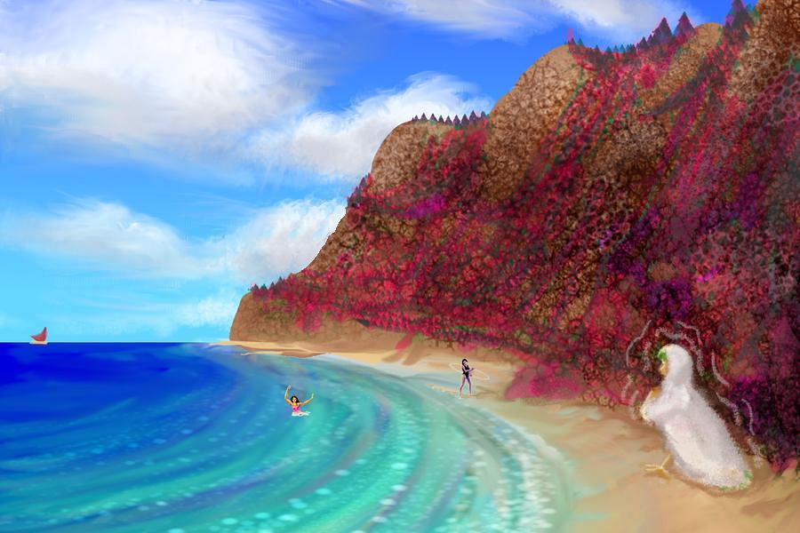
On the third day, we round Cape Boreh at last to find into Rimshak Bay. It's just the mouth of a long valley so deep and sheltered from polar storms by the Boreh Range that the lowlands are boreal rhodoforest. A somber plum-red, almost purple, but stil the first really extensive patch of rhodophores you've seen yet on this trip. But emphatically not your last. It'll get hot and red yet; on Capsica, it always does.
Skirt Rimshak Bay. Bigger than it looks--takes a full day on the wing.
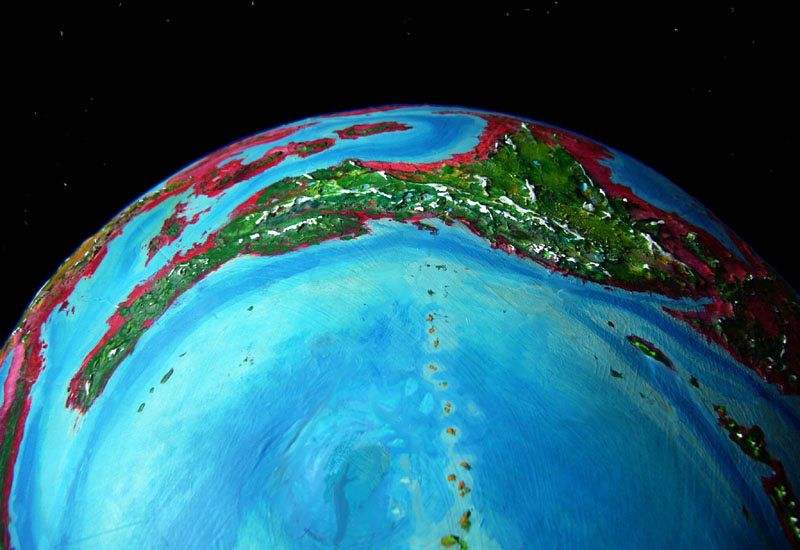
Next day we follow the shore steadily west, past winding maroon islands, mere Whidbys and Long Islands at first, but at sunset, a rugged giant trails off northwest, over the polar horizon--K'Kuur, the size of Vancouver Island.
Usually, on these tours, I recommend you do as the Capsicans do; they're better fliers and know the territory. But here, I'm going to disagree with the majority of our hosts. Because a host of hosts is pouring off that island! Out of the sea--from the Ralopa Atolls, over the horizon, flaps a horde of tired, sick travelers. They're at the end of the grueling Nohaa Flyway, the only practical route across the Arctic Ocean. This is the tail end of the season, so you're seeing the tiredest stragglers. Not that anyone finds it easy or fun. Cold, hunger, fatigue, Arctic sun-glare, disorientation, and for the last few days, not much drinkable water out there.
Many of these Capsicans are heading south, but they're reluctant to go inland across Tliss Plateau--not in their debilitated state. Too high, too cold.
Not Capsican cold--real cold. Some streams you cross (and drink from, after locals reassure you) are a startling milky turquoise from glacial silt, rare on Capsica but common in the Tliss Range. This coastal range tops out over 9 km high (30,000'). Pinelike forests and alpine meadows below ice-carved horns; a green world, astonishingly Terran.
I recommend a venture inland, exploring Tliss's scenery, but all the Capsicans hug the coasts. It's understandable; They start shivering as temperatures drop past 35-40°C (95-104°F); they're struggling to maintain a body temperature of 70°C (158°F!). It may look comical to Terran tourists enjoying some relief from the usual heat, but in winter the locals here, who have long fluffy fur even for Capsicans, wear heavy fur cloaks layered over that, grounding them till winter fades. Capsicans hate turning themselves into chubby, flightless penguins, but it's that or die in the Arctic cold--10-20°C (50-68°F).
Anyway, enjoy what the locals can't--wander inland up the Fori River. You can even cross the pass--just manageable, though you'll be working hard, climbing at nearly 4 km (13,000'). If you're tired of arctic scenery, you can cut this trip short by heading south for a day or two, crossing the mountainous neck between Tliss and Bel's heart, Sirru Plateau, you'll reach Cape Zil's south shore--much warmer. You can even swim in the sea. Quite Caribbean, but the beaches won't be crowded--for Capsicans, the water's icy, the swimming season long over.
If you glide back down the Fori to the sea, and continue west, it's placid for a few days--narrow red bottomlands between low olive hills. One day, not a snowy peak's in sight--a first on this trip. But after you cross the wide muddy mouth of the Drir, the mountains soon return, even crowding up to the shore. For the next few days it's as rugged and Alaskan as the early days of the trip, out on Zil Peninsula. The difference is that those peaks were the rim of a rugged upland hundreds of km wide; but beyond these snowcapped fangs run alpine highlands for nearly 2000 km (1250 mi); the Sirru Plateau's larger than Tibet. I'll try to get you across alive, but there are washboard ranges you'd have to cross if you tried here; our route still lies west.
In the meantime, enjoy the beaches while you can. Soon you'll need that coat.
Introduction - northern Zil Peninsula - Sirru Highlands - Smolda Pen. - eastern Sirru - southern Zil -
After a couple of days on the flanks of week of steady flight west, you face a choice--either you stick to this tour, heading south into Bel's rugged interior, or you continue along the north coast, exploring the ridge-mazes of northwest Bel and the deserts of the southwest.
Let's head south into the mountains of Sirru Upland. By now it's late fall, and pleasant for Terrans there--mountain meadows, daytime temperatures no more than 20-30°C (68-86°F) and downright chilly at night (you DO need that coat), below snowy peaks 7 km high--not too rare in Capsica's low gravity, but these are particularly impressive because unlike most of Capsica's mountains, some are ice-sculpted--not as massively as many of Earth's, for Capsica has no cyclic Ice Ages--but noticeably. Horns, cirques, cliffs.
The main problem for tourists is that it's TOO Terran--including the air pressure. It's a mere 1.4-1.5 atmospheres up here, not the 2.4 you have under your wings at sealevel. Capsican are strong fliers with a big safety margin; you're not. Passive soaring's still quite possible in air this thin--low gravity helps--but flying under muscle power is very hard up here! It's why I led you west an extra week. You could handle the cold of the high, snowy, washboard ranges of northeast Sirru--better, indeed, than the natives--but you couldn't fly those high passes. The western rim of Sirru will be hard work, but passable. And at least as scenic.
Right at the western rim, Sirru breaks up into rugged snowy fingers--the Aissa Range groping west, some 8 km high (26,000'), and the stubbier Trosh Range reaching southwest, topping out at a mere 7 km (23,000'). Both ranges are a good six km (20,000') above the hot dry basins at their toes. Earth has few mountains this tall head-to-foot--Nanga Parbat, Dhaulagiri, Denali, Santa Marta--but in Capsica's lower gravity, such giants aren't as rare. These huge ridges generate updrafts the natives can ride west to Northwest Bel, but beware--the ridgetops are too high for tourist fliers like you. You won't black out, but you can't get enough lift. Nor can you swoop to their feet; that's deep in the hot red zone, though it doesn't look red--too dry for much vegetation of any hue. The Tsung Basin is a hazy dun barely blushed with pink; it could almost be the Taklamakan, or Death Valley. But you can, with care, steer along the Aissa front waist-high, between the crash and the oven zones, to Northwest Bel. But that's another tour.
Instead we'll slip east of these monsters, across Rethica Steppe. Thin air and hard cruising, but level at least. And pretty. Vast emerald grasslands--real green, not dull pink savanna or tan desert. Green, with looping little creeks, and snowy ice-cream scoops on the horizons all round.
All this lush Rethican grass looks like good grazing. You're puzzled why you don't see vast herds of... something. The answer's that few animals can gain enough energy from the grass to sustain a body temperature near 70° (165°F!)--at least while remaining light enough to fly. Big animals lose little heat; mammoths or moose or even Terran horses would do fine here. But few Capsican animals are that massive--they need to stay light to fly in the thin upland air, and flight's needed on a world of winged predators. Any single factor--the need to bulk up for insulation, the contradictory need to stay flight-trim, the low energy yield of grass--is solvable, but together they discourage grazers in cold regions. Capsica's uplands and arctic have an empty feeling; plant life has adapted but hot-blooded animals generally haven't. The one area where you do see herds munching green grass is the Antarctic highlands--Hithluma and the Dragonspine Range. The commonest animal there is the flightless licha, a grazer with ridiculously thick fur: like a deer with a Persian cat-coat and silly vestigial wings, like a costume from a Nativity play confusing the asses and the angels.
But few animals at lower latitudes have followed the licha. Would you give up flight for a steady meal ticket?
Through Natna Pass, our highest and hardest, 4.6 km up (15,000'), and southeast toward the Lake District. Scenic!
The Wen-Zagrin Lakes are a cluster of large, high-altitude lakes are nearly 4 km up (13,000'); the peaks above them on the west reach over 8.5 km (28,000'). All the Wen-Zagrins are freshwater. The first we encounter is Rin, the highest and westernmost. It's an eerie, milky turquoise from glacial silt. Zag, downstream to the southeast, is a clear blue. By next day we reach Wen, the easternmost and biggest, some 140 km long and 80 wide (85 by 50 mi). Wen's a famously deep azure (silt-free and very deep). The lakes are apparently named for a rare, aromatic Capsican herb surviving hard frosts, found only in the Sirru highlands: wen-zagrin or wintzagriin.
From Lake Wen, we climb west through a twisting pass to the very rim of Sirru, and south along the face of the great wall. Steady trade winds, updrafts, relief! The air may be thin, but the flying's a lot easier. Physically. Mentally... as on the Aissa flyway, follow Buddha's Middle Way (or Goldilocks's if you prefer): not too high (crash!), not too low (roast!) and you'll be juuuust right. As in not dead.
Grand cliffs. Earthlike peaks above, alien redscape below--hazy plains warm even now in winter. Inland basins with little rain--more than the landlocked Tsung Basin, but dry savanna, pale lavender and pink; trees only along the streams spilling down from the mountains.
South for days. Ride the wall. The lilac veldt below humps up into a knot of wooded hills, dusty brick below but crowned patchy olive-green. Then another coastal plain, clearly rainier--more red groves break up the pale savanna. Clouds to the southwest, and even a furtive gleam that might be Ranu Bay, a good 250 km away--and at least 4 km below you.
Introduction - northern Zil Peninsula - Sirru Highlands - Smolda Peninsula - eastern Sirru - southern Zil -
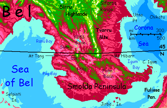
Now the views get even wider. The great ridge bordering Sirru starts to fray; the plateau behind it sags in terraces until you're riding atop a line of warm green ridges, the Sumbin Hills, dividing the west-coast plains (pink meadows and red groves--Mediterranean in essence though much hotter of course) from scorching near-desert to the east, where meager streams from southern Sirru wind down to salt marshes and lakes (dry most of the year).
The Sumbins themselves aren't too bad. Most peaks aren't much over 2 km high (just 7000') but occasional volcanoes climb to 3 or even 4 (10-13,000'), high enough to be cool at this latitude in winter. All are green, wooded, rainy enough for small creeks and springs even high up; you don't have to go far down into the hot zone for water.
But you could. We're still just over 45° north, and it's full winter now--Capsica's year is just 9 months long; seasons are short. You can even swoop down into the coastal lowlands--with caution. Hot, but not Tsung-Desert hot. Often cloudy & rainy--as opposed to summer's oven-heat (relieved by occasional hot-water typhoons).
At last, the flyway breaks up--the low mountains fray into hills. The best ridges head west and south toward the coast, but trust your guide: you want to go east. Ride thermals up the windward faces of the higher volcanoes, and glide across to the next sky-island, as much as you can--a harder path than the steady, effortless windwalls of the last few weeks, but feasible.
The last of these big cones is Mount Tong, like Fuji's big brother, 4300 m tall (14,000'). You camp high on the shoulder. Even on little Capsica, with its sharp curvature, the horizon's at least 200 km away (125 mi): green heights, red slopes, mauve pink and tan lowlands.
Next dawn, something casts huge spectacular shadows, streaking the sky ahead. It's Mt Hibarr, a snowy Himalayan peak just over 8 km high (26,300') standing alone at the end of the Tvarru Range; a landmark all over the south. From snowy head to scorching savanna toes, Hibarr is 7 km tall (23,000'); taller than Denali or the Santa Martas or even Nanga Parbat, the tallest head-to-foot mountain on Earth. Oh, if you drained Earth's seas, Hawai'i would be taller; but Capsica's low gravity means Hibarr has a hundred big sisters, some even taller than Hawai'i.
For now I'll just describe the lowlands to the south, and head for Hibarr. It's more of the same, anyway--all of southern Smolda has coastal plains a few hundred km wide, with hills (by Capsican standards) inland that cut off a set of central basins like Filfil and Fishn. The ranges have a few volcanoes high enough for comfort, but no sustained heights like Sirru Plateau in the north. The lowlands are just survivable for Terrans--for a month in deep winter. The reason to visit, if you do, would be to see Capsican cities--this is a wealthy and fertile lowland, though varied from open range and meadowlands to the west to dense woods--mostly orchards--in the east. Still, I wouldn't; humidity's near 100%.
While I haven't mentioned Capsicans yet in many places--virtually none on this tour--it's not just because I focus first on the land and climate, then come back to build species and culture in a second pass--although that's true. It's also just... you're doing the equivalent of touring the American West, plus the wilds of Canada and Alaska. Anywhere comfortable or even bearable for you means it's not much settled by the natives. And this is their off season--cold, scenic highlands at their coldest.
It takes all the next day to reach the west face of Mt Hibarr, and half next morning to round its massive shoulder. The Tvarrus recede out of sight to the north--a steep unbroken wall 6-7 km high (20-23,000'), snowcapped in many places, lying right across the prevailing winds, generating huge updrafts. A perfect flyway!
But not our way, not yet. I'm having second thoughts. Let's head southeast along low hills, olive green in the distance, dotted red and green up close. Camp at a bend where the hills jag due east.
Here you get a choice. I plan to lead you east another day, as the hills dwindle and the red trees crowd out the green, to Cape Igum, scenic but a dead end.
Those who think I'm wimping out, who want to see the real Capsica, have another option: head into the lowlands to the south coast (again, the most densely populated and fertile part of Smolda; but 35-40°C even now--95-104°F, and humid). You can even island-hop along the Jirba Chain over the Bel Sea to the Fulisse Peninsula, the southeastern lobe of Bel. And NOT the hottest, though as you grab thermals to keep you high above its scorching savannas, you'll swear it must be...
Let's go to Cape Igum and swim instead. Ruby forest clings to dramatic sea-cliffs above blood-warm turquoise water full of fascinating reefs. Stay in the water or the shade, and it's almost bearable now in late winter. Almost.
We can't stay long. Spring is coming. We need to flee north before the killer heatwaves start.
Back to the Tvarru Range, and north along its huge snowy ridge, back to the east side of Sirru Upland. A week or more. Keep moving! Winter's ending.
Introduction - northern Zil Peninsula - Sirru Highlands - Smolda Pen. - Eastern Sirru - southern Zil -
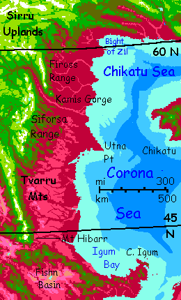
North, riding the winds as late winter warms to early spring. Don't dawdle, or you'll regret it! Though... it's easier flying back than it was coming south. Great ranges border Sirru Highland here on the east rim--first the Tvarrus, then across a narrow gorge to the Siforsas. Rising directly across the prevailing winds, these ranges generate steady updrafts--windwalls, as the Capsicans call them.
Windwalls easy enough for even a tourist to ride. And you do. For days.
Then comes a gap where a great canyon, Kamis Gorge, drains northeastern Sirru. Camp, sleep. You wait all morning, resting up; start across at noon. You spiral up as high as you can, then head northeast over the gorge. You'll lose altitude steadily, from over 5 km down to 1.5 (about 3 mi to 1) over the 90 km (50 mi) between the ranges, but by the time you reach the west face of the far range, the afternoon sun wil have heated them and updrafts will get you back to cooler heights. A hard day's flap, but you're in condition by now.
Really, this whole tour is too easy, compared to Kifura or Az!
Northeast of the Kamis River rises another long range bordering the plateau--the Fiross, a jagged steep mountain wall 6 km high (nearly 20,000'). Great scenery, easy windriding.
Two long lazy days, up to the Bight of Zil.
Time to swing east, and finish the loop.
Introduction - northern Zil Peninsula - Sirru Highlands - Smolda Pen. - eastern Sirru - Southern Zil
The south shore of Zil Peninsula looks redder than the north--there's green here only on mountain-shoulders--yet it feels about the same--pleasant warm days, nippy nights. This is seasonal illusion. We traversed the north not long after its warmest days, in early fall; here in the south, it's early spring--a much colder part of the cycle. Why aren't you feeling the cold, then? Well, we're sheltered from those polar winds. Here summers hit 55°C (131°F)--and it's humid heat. Not the time to visit! Even now in spring it's 30°C at sea level (86°F) in the day, cooling to 20 at night (68°F). Warm enough for a fine swim each afternoon, but cool enough so you sleep well, and don't overheat in flight.
Not that you have to work much. It's time for me to praise my great wisdom again! Here on the south side of the Peninsula, the prevailing winds are mild but generally blow to the east, not the west as on the north shore. I chose our route (and its latitudes) carefully. Widdershins (counterclockwise) is the way to tour Bel; the winds favor it.
Today, few humans plan their voyages based on the wind, but two centuries ago at the height of the Age of Sail, everyone knew there IS such a thing as a free lunch. But the Capsicans, living on the wing, have never forgotten.
So it's not long, really; less than two weeks.
At first, low green and olive hills, tailwinds, plum-red lowland woods broken only by meandering rivers. Except for the color, it could be primordial Ireland. The great mountains of Sirru seem gone for good.
One night, you actually camp on a beach.
Day three, you round Ulana Head. A hundred difficult miles north--Ulana Bight is wind-sheltered, and what breezes you find blow down from the hills. No assists here! On the other wing, though, the humidity drops. Less rain here. The monotonous red woods open up--magenta lowland pastures, plum-purple groves, eye-searing mixed hillsides where red and green pixels jostle, chartreuse hill-meadows on drier slopes, olive and forest greens in hanging valleys...
For the next three or four days, straight east. The peaks of the Mistei loom above you, green-shouldered, white-headed--they're Himalayan, and it's winter, and over 60° north; even Capsica can't heat those heights. You ride the winds across their ankles, no higher; no need. The sense of danger, of that hungry sea of heat waiting to get you if you sink, capsize, lose your wings, lose your way, that's haunted you all over Capsica--and it's a realistic fear!--just as fear of the sea was realistic in the Age of Sail--fades away. This place is safe. Just wind, the great white-headed mountains, the beach.
At last the Misteis retreat inland. The coast does too, a bit: Jenlet Gulf. Little hummocky hills--that don't give up at the shoreline but fill the gulf too. Tiny, craggy, red and green islands.
At the east end of the Gulf, you swing south 80 km (50 mi) to blunt Jenlet Head. Here you have a choice. The islets off the point lead 110 km (70 mi) south to Dehora, a jugnly, triangular island big as Newfoundland, just off the west coast of Chai, the big, rawboned continent to the east. Few locals seem to be doing that now, but in summer great flocks do--though they're mostly not Belian but Archians from the far side of the world who just traversed the grueling Polar Flyway. Or Chaians heading for the Arch. But that flyway shuts down in the colder, darker months. Just a few couriers with really urgent news justifying frostbite.
You don't have to head for Chai. You can keep east, finish the loop. Another day of long ridgy islands and narrow sounds--the Linjira Islands--and two more of straight bare coast, warming to full spring now, which'd mean trouble except that as the sun creeps north, the latitude does too--Zil is narrowing. At your starting point, 66° north, it's not even 30°C (86°F).
Full circle. With only wind and muscle power, you just traveled 10,000 km... in a couple of months.
Lewis and Clark never had it so easy.

World Dream Bank homepage - Art gallery - New stuff - Introductory sampler, best dreams, best art - On dreamwork - Books
Indexes: Subject - Author - Date - Names - Places - Art media/styles
Titles: A - B - C - D - E - F - G - H - IJ - KL - M - NO - PQ - R - Sa-Sk - Sl-Sz - T - UV - WXYZ
Email: wdreamb@yahoo.com - Catalog of art, books, CDs - Behind the Curtain: FAQs, bio, site map - Kindred sites