Capsica's homepage, map, giant ref map, geography, gazetteer . More worlds? Planetocopia!
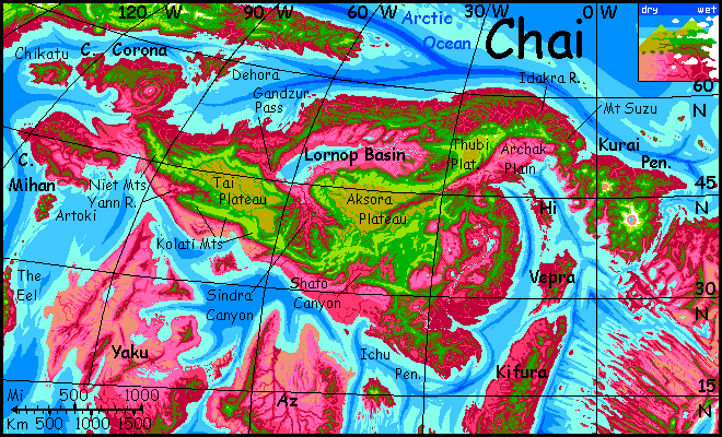
 Capsica: Chai
by Chris Wayan, 2011
Capsica: Chai
by Chris Wayan, 2011
INTRODUCTION
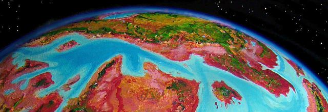
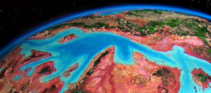
Chai is a temperate northern continent about as big as South America. This being Capsica, that sentence has some slippery words in it. "Temperate" here means some parts of it wouldn't instantly bake you to death, and the highest mountains occasionally see a little snow. "Continent" and "big": if Chai were plunked down in our Pacific, it would would be smaller than Australia, for most of the Chaian rise would be drowned under our much deeper seas--only the central plateaus and the northeastern shield volcanoes would be land.
Don't believe me? Which would you rather live on, Earth with half the water, or double? 35% land, or 1%? No, those numbers aren't errors--that's what halving or doubling our water volume would leave.
A world having shallower seas with long, fractal coastlines has some advantages over Earth. Capsica is such a world. Chai illustrates these (mixed) blessings. The rich lowlands of the east and west and north just wouldn't exist on Earth. Okay, the savagely hot deserts of the south and southwest we could do without... and frankly, so could most Capsicans.
TOURING
We'll start our tour in late fall, when the central and northern uplands are cooling rapidly from their late-summer peak of 50°C (122°F), down to tolerably torrid. If we waited till midwinter they'd be pleasantly cool (even a bit chilly if you're a subtropical Terran like me); but I don't want you getting used to Terran temperatures! For I want us to hit the long southern and eastern coasts in deep winter; it'll be hot even then, but spring or fall would be fatal.
But if we start now and fly counterclockwise around Chai, both heights and lowlands will be uncomfortable but livable... I hope. Any Terran travel on Capsica is something of a gamble.
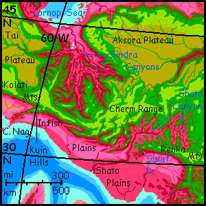
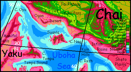
EAST CHAI
This part of the continent gave rise to its vaguely Asian name. What else can you call a land with a high, quite Tibetan plateau to the west, two great rivers, a gaggle of central lakes, a rugged Korean peninsula to the northeast and an Indochinese one southeast, gentler eastern mountains, and a long curving coast like a fat Buddha belly, with Taiwan- and Philippine-size islands offshore?
Okay, it's not China: much of the interior around those lakes is savanna not ricefields, for water evaporates faster here and the rains don't penetrate as far inland; one of the two great rivers never does turn east, but meanders south all the way to the equivalent of Vietnam; the great plateau mostly feeds internal basins, not the long rivers of Tibet. And, of course, summer temperatures range from 50-60°C (122-140°F) along the lush coast to as high as 75°C (177°F) in the inland savannas and deserts.
Still, East Chai, while very hot, has no true desert. The locals will find the tropical south quite pleasant; an Eden shaded under lush trees full of fruit, much like parts of our Southeast Asia. The east coast gets plenty of rain all the way north; the dry season's longer but much cooler, as low as 40°C (104°F). The humidity is still 70-80%, so I don't recommend even winter visits.
But that's just the lowlands. The Coast Range, though too low to cool you much, is still high enough to block most storms from reaching far inland. Here, let's be uncomfortable. It's late fall/early winter, and you're standing atop a mountain in the southern Coast Range, at the edge of an abyss.
To the west and northwest, far below us, is a pink and lavender savanna, veined in red; a few puffy clouds, startling in that they're familiar white. A silver snake, the Long River, meanders drunkenly at your feet, heading generally south into redder pastures--bending slowly west and disappearing in steadily denser clots of ruby forest. From this spot, you can actually see the rainshadow of the Coast Range--savanna to the north, where the ridges block storms, but unbroken woods to the south where the hills are lower.
On the western horizon rise the Renkas, whose red feet but cool bluegreen heads tell you they're at least as high as the Andes--on Earth they'd be snowmantled. But at this latitude on Capsica, forget the snowline--it's an achievement just to rise above the greenline. Where we stand, it's just 35°C (95°F), nearly as cool as you'll ever get, here in the East.
To the east, rumpled red hills fade to pink and then violet at the hazy horizon. Cloud-dappled, those foothills look cooler, but they're 45°C (113°F) at the moment.
North and northeast are more whalebacks of bronze and olive above red valleys--the highest ridges just reach the greenline, like this first peak of the Coastals. They're our route--but first, get airborne.
Spread your strap-on wings and grab air. Now jump off the scarp! Good, you remember your lessons--you're still alive. But gliding won't be enough. The prevailing winds are downslope here, though the heat of the savanna creates updrafts too. This isn't Terran hang gliding--here, you practice true powered flight. Underpowered by Capsican standards, but in this low gravity and high air pressure you can fly. It's the only way to get around, since most natives fly. There's little infrastructure of roads--why build that when you have freeways in the air? Just follow the locals--find the updrafts on the east face of each ridge, the coastal face. These form a writhing, tricky set of steppingstones above the heat.
For the next four days, you learn to master flight on an alien world. At night it often cools to 30°C (86°F). See, Capsica's kind--she's sending you her best, so you get a few days to acclimate.
What's the Long River floodplain like? My first thought was of the Mississippi, but the surrounding plains are too dry; my next thought, of the Nile, is equally inaccurate: this isn't desert either. Our Senegal River may be the best Terran analogy: the land outside the floodplain is dry much of the year, but it's good grazing land with scattered trees. If gardened and not deforested, it could sustain a rich civilization.
Instead of our Mississippi or Nile's fairly predictable yearly floods, levels will depend on the rather irregular rains in the east, north and west. Still, the river never fails; these three feeder-regions are very different, and drought or flooding in all three simultaneously is not common. So I'd look to the Long River as having real potential for a literate civilization--but one with perhaps less confidence in the gods than in its weather bureau. Oh, they'll have one by the time they leave the Stone Age. Since Capsican people will probably fly (again, dense air and low gravity) travelers and traders will be more welcome for their informational gifts than material ones; weathernews traveling on the wing at 60-100 kph (40-60 mph) can easily outrace most stormfronts and floods. Fliers don't really need weathersats!
You head north. Red lush valleys to the east, lavender savanna of the Long River to the west. Two days in, the plain turns silver on the horizon all day: long Lake Tis, the largest of the Rotisri complex, nearly the size of East Africa's great lakes. Two, Lake Kumis and Lake Ro, are well west and southwest, hidden by the inland ranges; but the next day smaller Lake Ri shines all morning, a great blue eye in the pink bowl below you. The last night atop the summit of Mt Hhuyu, a massive volcano, it drops to a frosty 25°C (77°F)--extraordinary this early in winter. Enjoy it while you can. Past Hhuyu, the Coast Range dwindles. A day north, we pause to camp on a hill a mere mile high. The last gasp--and you do gasp. The heat's stifling.
Ahead, the olive slope plummets into a sea of red. By now you understand what that means!
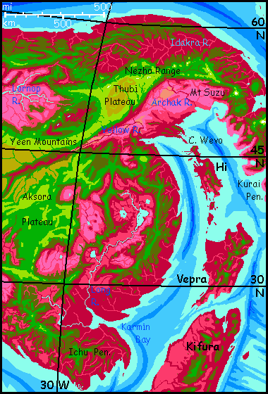
NORTH CHAI
The North is mountainous, and this near the pole, that means its climate is chilly by Capsican standards. Only the highest peaks see snow, but they are high--the shield volcanoes in the far northeast may be old and eroded, but they're still 6-10 km tall (20-33,000'), high enough for heavy winter snows. In the east, several peaks of the Yeen Range on the north rim of the Thubi Plateau rise to Himalayan heights as well.
But it's not all heights. Soon you'll wish it was.
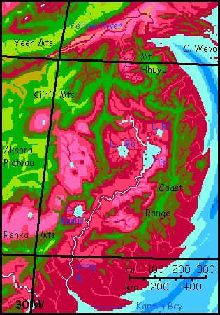
From the last of the Coast Range, we set out over the huge triangular flooplain of the Yellow River. No, really, it's called that, for the same reason as China's--inland, it cuts through a lot of dry dusty hills. And that dust turns to mud...
The Yellow Plain (lurid vermilion--sorry, but the locals named it not for its perfectly normal vegetation but for the river, which really is a muddy gold) is a good 45-50° north, geographically comparable to the Quebec's St. Lawrence, or Siberia's Amur River. Fall's ending now; the chill of early winter brings the great plain down to 40°C (104°F). The Yeen Mountains to the northwest are as high as the Andes--comfortably cool for Terrans--but I'm going to ask you to endure crossing the plain instead.
The reason's simple; the Yeens, and the Thubi Plateau behind them, and the Nezho Range on the far side of Thubi (highest of all), form a Himalayan barrier with no passes low enough for you. You wouldn't freeze of course (only the highest peaks of the Nezho Range see much snow) and you could breathe even atop Mt Nezho itself (Tibetan air pressure, but merely Lhasa, not the summit of K2!) but the lowest passes are over 5 km (over 16,500') and you can't possibly fly up there. In air that thin--little more than Earth's at sea level!--even natives falter, and they don't have your clunky Terran bones. No, you'd have to pack across the Yeens and the Nezhos for sure; probably across all Thubi. It'd take forever.
So our path heads northeast! Prepare for a rough couple of days. The Yellow Delta is mercilessly muggy--as humid as the Amazon, Congo, or New Guinea, but much hotter. And the clamminess fools you--in that heat, you'll dehydrate fast and not feel it. So, three survival tips:
Now that we've eliminated the daredevils and masochists...
There is one route that'd beat the heat. You could fly up the Yellow River to its source on the Aksora Plateau. The Yellow Gorge is about the only entry to Aksora that avoids crossing Himalayan ranges. Looking at Aksora on the maps, Terrans inevitably see Tibet; but there are differences. Tibet oscillates from dry brown near-desert to frozen white each year; the air's thin and rains are cut off by high mountains all around. Aksora's air is much denser and holds more water. Cold drizzle in winter, with a few snow flurries at most; hot thundershowers in summer. So Aksora's green in winter, red in summer; two annual blooms.
But animal life can't so easily adapt to the winter cold. Grazers do migrate up to those lush red summer pastures, but the equally rich green winter bloom is grazed only by a few species of flightless high-altitude furballs. For most creatures the food (and the predator shortage) can't compensate for air temperatures about 60°C (108°F) below body temperature. Every minute, calories lost! Capsican higher life, by adapting itself for the lowland heat, has boxed itself in.
Yet Terran horses or buffalo would find Aksora heaven--if it gets too hot in summer, or those red plants taste funny, they could just amble up into the Himalayan ranges all round Aksora and find greener pastures. Literally greener. Or they might find they like their fodder red.
Strictly a fantasy detour! You might flap around Aksora, slowly, with practice and effort. But you couldn't possibly fly over any of the high passes to escape the plateau. You'd have to trek. And exploring central Chai on foot would take months; the uplands are twice the size of Tibet and its attendant ranges.
Well, there's one pass in the southwest you might just manage, after some toughening up--but it drops into the savagely vertical Sindra Canyon, a Martian labyrinth of cliffs mesas and gorges two miles deep, full of tricky winds. You'd face over 1000 km of wild, raw, empty country before we could reach the Lornop Sea, and even that has harsh climate for Terrans. There's a reason billions live on Asia's coasts, while Central Asia's empty--and Central Chai's much rougher! If you got into trouble your bones'd never be found. No, in the end I'd have to insist that you glide back down the Yellow Gorge the way you came--weeks later.
And by then, the Yellow Delta's heat would've cooled to winter lows of 30°C (86°F)--much more comfortable. But then we'd be facing the really hot parts of Chai, the southwest and south, fatally late. Trust me--we hurry now to beat spring, or we die. So skip the Gorge, and head northeast. Curse me (or our insurers) but do it.
So you sweat and flap and curse and sweat your way (did I mention sweat?) across the sticky Archak Plains, toward Inguri Pass. An hour past the Archak River delta, a monstrous white cloud appears on the eastern horizon. But it never moves--just grows clearer and harder by the hour. It's a cloud of stone, of course--a titanic near-Martian volcano looming through the haze. Mt Suzu is first of the Kurai Peninsula Chain, a string of "hotspot" shield volcanoes like our Hawaiian chain--but the Kurais are exposed, head to foot, forming a cape as big as Indochina; that's why I built a separate tour for it.
Suzu's heavily snowcapped, for it rises to 10 km--33,000'. That's respectable for this chain but not extraordinary--Mt Kurai, still 1000 km over the horizon, reaches 14 km high, or 46,000 feet! Sounds impossible, but remember Capsica's low gravity.
Speaking of snow... you can't see this from here, but one point on Suzu's southern rim, where the cliffs dropping into the gargantuan central caldera face north, has a true glacier--snow not only persists year-round, as on the rest of the rim, but compacts to ice and creeps a kilometer down a ravine in the shadowy face.
But our way leads not toward Suzu but north, over Inguri Pass, a mere 3 km up (10,000'). Thin air and hard work, since the wind's in our faces, pouring down the mountain--but at least it's not stifling hot! Over the pass is another world: the shores of the Arctic Ocean, Capsica's largest.
The far northern coast of Chai, this continent's Siberia, is a mere strip, though a long and fertile one. We'd find it Earthlike--sort of. We descend into the Idakra Valley, a hot, rather humid monsoon forest with many red and purple trees interspersed with the green, at nearly 60° north--yeah, pretty Earthlike, huh? Capsicans would call the winters cold, meaning Terrans would find it pleasant (25-30°C, 76-85°F). In summer, it heats to 50°C (122°F) or more, so tourists will most likely stick to the much higher central mountains bordering the plateau, where a glider can ride updrafts for miles and the cold mountain air rarely heats over 30-35°C (85-94°F). And there's something to be said for the mere sight of snow, even if it's still miles above you...
A day angling north and a bit west, across the lower Idakra Valley, and we reach the arctic coast. We wheel left and head west along this endless shore. By day we ride the updrafts off the Arctic Ocean.
But ride the winds only till mid-afternoon, when the day warms up; then it's time to horrify the locals and go diving--naked, in winter, in the arctic! Terrans are crazy creatures! Be sure to boast loudly about it beforehand, in the local inns; you can win free beer, meals and beds with this gambit over and over. No one will believe you till you do it.
But that's not why we're diving. The Arctic Ocean is so cold it has extensive coral reefs! No, really, this makes sense. The cooler water can hold more C02 in solution, and thus can dissolve more calcium and magnesium, handy for building coral and shells. Really hot water just can't hold minerals in solution as easily; the bath-hot seas behind us tend to precipitate them out, like the deposits inside an old tea kettle. Many of those seas are nearly as mineral-poor as our freshwater lakes! Stone soup indeed.
Some reef creatures there do build shells, but slowly; some use bones or other once-living materials; some burrow into living rock or glue stones into shelters--laborious, but often easier than secreting a shell under the circumstances. The result: low-latitude reefs grow slower than Earth's, while storms batter them just as fiercely.
So luxuriant coral reefs and atolls on the scale of our Great Barrier Reef are strictly polar here. Wild and beautiful! Capsican sea life, presented with this sudden bonanza of cheap structural material, responds with a joyful building boom. Crazy towers, bowers, brains, fans, all the structures and colors seen in Earth's tropics, and then some. So dive. And then get your free dinner and drinks from the incredulous locals.
THE LORNOP SEA
After four days' flight west, the coastal mountains recede. A broad gulf's ahead, Lurik Bay; its shore's a great plain dotted with low hills. Though much cooler, its sheer size reminds you a bit of the Archak or the Yellow Delta. But the Gandzur River is modest--its source is just a few hundred km inland, at Gandzur Pass, just a mile high. Beyond isn't the usual Chaian plateau, but a vast inland basin around one of Capsica's many cut-off seas--former oceans! This one, the Lornop Sea, is about the size of our Caspian, but is set in a much deeper basin.
One can (with courage, luck, patience, and a mountain of visas and bribes) travel at more-or-less-sea-level from the Caspian to the Black, Baltic, Atlantic or Arctic Seas; and if global warming goes on, the Caspian will eventually re-merge with the world ocean in the end (probably to its ecological benefit, though we may regret it.) But mountains and plateaus 2-4 km high ring the Lornop Sea, with peaks up to 9 km (30,000'). Gandzur Pass is as low as it gets. Lornop was indeed a limb of Capsica's world ocean once, but that was millions of years ago; like our ancient Tethys Sea, its basin has been squeezed off. It never will rejoin.
Lornop is a world apart. Weak remnants of a few winter storms do make it over the lower northern ranges (2-3 km high; 6600-10,000'), especially around Gandzur Pass; but for the most part, what rain falls in the basin is generated by the Lornop Sea itself.
So the basin is essentially a monstrous terrarium. The Lornop Sea pools in the western half; the east, away from the Sea, is harsher. The northeast is tolerable--rusty trees line the tributaries of the Lornop River, with grassy lavender steppes between. South of the great river it's drier; not true desert, but dry pink to salmon savanna, with scattered stingy streams. The climate's harsh, and not just because it's cut off from rains; it's far enough south to suffer intense heat and evaporation in late summer--up to 75°C (167°F). But winters are equally severe, down to a shocking 10-20°C (50-68°F). Brr! Throw in wind chill (and winter winds get fierce here!) and that'll kill most natives almost as fast as true frost. Only the shaggiest native grazers can take it. Worse than Mongolian winters--for Capsicans.
The shores of the Lornop Sea are milder. Now, in winter, they look strangely Earthlike--the grasslands turn briefly chartreuse in the winter rains, as chlorophyll grasses live their brief lives. Soon they'll turn gold as these dry and go to seed in late winter, then blush pink and lavender as spring heats the soil enough for rhodophylls to bloom. Along creeks, rusty strips and groves where green and red trees mingle. We might call it Mediterranean, though it's hotter than Greece ever gets.
Much of the North's population lives here on Lornop's shore, farming and fishing.
THE NORTHWEST COAST
West of Gandzur along the coast, it's much like the northeast--an endless strip of empty forested hills. The only Capsicans you see are in fishing villages. It's too cold inland for them in winter, so they huddle along this lowland strip of mixed green and red forest--only venturing up into those deadly green mountains in summer, to hunt, herd, mine, log, and berry.
But this isn't mere harvesting, it's low-grade seasonal agriculture--they tend and plant berry patches, for dried yacha berries have an interesting flavor and are a mild stimulant; an ideal food for fliers needing concentrated foods to carry over deserts and sea passages. So this isn't quite the pine-green Nordic wilderness it seems now in the dead of an arctic winter. A winter so cold you're wearing real clothes for a change--jeans and a long-sleeve shirt!
For a week we ride the winds off the Arctic Ocean as they slam into the high coastal mountains, riding higher than most of our native fellow-tourists following this flyway. They're better fliers, but the heights are just too cold for them.
Well, that was true for the first few days. But around day four, the coast bends south a bit. Far offshore, the eastern tip of another rugged continent blocks the Arctic winds. Updrafts grow less reliable--though by now you're more skilled at sensing them them. For the locals there are compensations--the coastal ranges here, the Lura Mountains and then the Niet Range, are just as high--Andean--but distinctly warmer. Capsican fliers can join you on the cold but no-longer-freezing heights (30°C/86°F). Marginally tolerable for both! Borderzones are fertile mixing grounds. True of temperature too.
Oh. Speaking of temperature and mixing, there's something you shouldn't try...
UNDER THE CAPSICAN MOONS
One common fantasy about alien tourism won't happen on Capsica--or if it does, you'll regret it. Maybe you're thinking that a hot planet makes for hot people (true), and hot people make for hot sex. Capsicans and Terrans may indeed find each other mutually attractive, and touching and brief embraces are possible--but in this case, Blake is wrong: the road of excess leads to the palace of ouch. Capsicans will be repelled by your corpse-like coldness; you won't be repelled, you'll be burned, and I don't mean emotionally. Perhaps a pair of thought-experiments are in order.
Sorry; it just won't work out. Alien nookie may be yours, on Serrana, Lyr, or Tharn... but Capsica? Yoooou'll beee sorrryyyy.
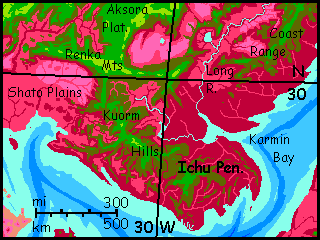
WESTERN CHAI
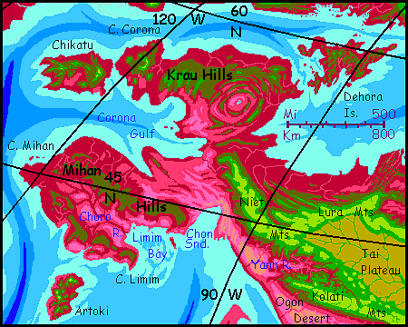
Northwest Chai is another world. It's a peninsula dominated by a huge radial structure--arcuate ridges and valleys much like ripples in a pond cup a central, lake-filled depression. It's not an impact crater--way too many rings! While strange to Terrans, Venusians would find it familiar: a corona, a patch where crust either upwells in a slow-motion fountain, or puckers in, sucked down like a whirlpool. Earth may have subtler analogs--geosynclines and anticlines--but nothing so blatant! Whether Cape Corona is an "innie" or "outie", I'm not sure, but either type of coronal structure on this scale is evidence that Capsica's interior is hotter than Earth's. And Cape Corons's no lone fluke. Contemplate the world map for a while and you'll notice a lot of Capsican islands and archipelagoes about the same size, and often roughly oval. This isn't my lack of imagination, but a geological process. Even the local map reveals half a dozen less defined coronae dotting the Cape and the waters offshore. The southwestern peninsula, Cape Mihan, is probably a large elongated corona--just tilted and partly flooded, camouflaging the signature oval shape.
But that's geology. What's it like here? That's like asking what America's west coast is like! Cape Corona and Cape Mihan and their attendant islands stretch between the latitudes of Bakersfield to Sitka. From north to south:
Dehora is rugged and the right size for a corona, but not radial in structure--instead it's a fairly random mass of overlapping volcanic cones heaving out of the shallow sea. This is a common sort of hybrid corona seen near active trenches. The trench subducts abyssal ooze, which heats up and forms light magma, too light to be happy deep underground. Back up it comes, but not spread out in a Terran coastal range but a crazy eruptive patch--and voilà Dehora.
Still think Dehora's unrealistic? Tell me that again after you've seen its Terran twin--Iceland. A classic Venusian corona!
The concentric arcuate ridges of the Corona Hills tend to shunt storms away from the heart of the corona; so it's grassier and more open than the rest of the peninsula. At its center is brackish Heart Lake, 40 km (25 mi) across; a miniature sea, since the curving maze of ridges allow no outlet. A little bit of East Africa amid all these Oregonian forests... and deadly to Terrans, with winter temperatures still in the low 40s (104-113°F) and usually much warmer. If you visit, skirt the corona--stick to its outer, higher, cooler coastal ridges--the Krau Hills.
The tip of the Cape is a second, smaller, less defined corona. But clearly an "outie"--its central arc of mountains rises to 3 km high (10,000'). These heights are cooler and wetter, more like Dehora's hills. Chilly and green, they're inhospitable to native Capsicans, but livable for Terran tourists when the lowlands start to roast...
But Artoki's not all "Mediterranean". There are five volcanoes over 3 km (2 mi) high; the highest three reach 4-5 km (13,000-16,500')--the tallest peaks in all of western Chai. Still, none ever sees snow, even in deepest winter. But their summits aren't just spectacular viewpoints but islands of Terran climate--what for us will seem lush subtropical forests. If you do visit, head for these. You can hardly miss them.
But you may miss their implications. The presence of so many tall volcanoes blowing off that much tectonic steam will tip off the observant tourist that we're on the edge of corona country! We're on a new tectonic plate where the pressure's relieved in an almost Terran way--the northern tip of the Eel Plate to the south, with its quasi-Andean mountains paralleling a long trench.
A flyway does lead south from Artoki to the equatorial continent called the Eel, but it's not recommended for tourists unless you're dead-set on seeing the more dangerous parts of Capsica. Emphasis on the "dead." The Eel has a spine of high volcanic peaks much like Artoki, making it possible for Terrans in strap-on wings to travel the Eel head to tail (with caution); but the nearest tip of the Eel lies nearly 1000 km south of Artoki; and while islets do punctuate the flyway, their hills are not high enough to offer Terran temperatures. It's a grueling passage, even now in late winter, the coolest time of year: about 45°C (113°F) most days. If you want to risk finding islets by moonlight, you can fly by night--it may drop to a mere 35-40°C (95-104°F). Then you can sleep through the day-heat--or try.
And don't get your hopes up about finding a nice cool cave to beat the day-heat: just as on Earth, most caves here have an even temperature close to the year-round day-and-night average for the region; but that average, at this latitude on Capsica, is 45-50°C (113-122°F). No escape undergound! You'd do better with a hammock under a tree all day, and even then...
As I said: not recommended.
SOUTHWEST CHAI
The southwest is mostly desert, even along the coast. Prevailing winds come from inland, off the high central plateau. Terra has similar coasts--consider the delights of Balochistan or southeast Iran. Heat another 35 degrees, and you have the Ogon Desert, the long dry coast south of the Kolatis. Or rather you don't have it. You can't touch it. Even in winter, the rocks heat enough to burn you.
So what we're really going to do to complete our circumvolation around Chai (circumvulturation? Most of the way, we've been riding updrafts, not truly flying) is to go where the winds are. And the best updrafts aren't in the Ogon Desert but inland, along the craggy shoulders of the Niet Mountains, on the south edge of the central plateau, above the greenline (still far below the snowline--in summer, that's at 9 km or so (30,000'). Plenty of peaks in the Niet reach that; Capsica has tectonic vigor, low gravity and low sea levels. Not that it's really any ruggeder that supposedly gentle Mother Earth. Remember, she wears a big blue dress--but Capsica strips to a teeny weeny turquoise bikini. Showoff! (To see Earth with most of its water removed, check out Siphonia--a wild craggy landscape nearly as extreme as Capsica's!)
Not only is the central chain of plateaus the only tolerable route back to our starting point; also, the updrafts around the Himalayan peaks of the Niet form a natural flyway--much of the year, as the furnace-heat of the inland basin to the north lifts air into the stratosphere, it sucks maritime air toward it, generating monsoon winds. Not always rain, but steady winds--that the Niet Range and its sisters transform into updrafts. Tricky--these are rugged mountains--but you can ride these winds thousands of miles, with practice, barely flapping a feather. As a result, you'll learn plenty about the South Coast here--the skies are full of Southerners, even though it's cold for them up here.
But half the horde of critters riding these winds aren't local at all--you'll meet tourists and travelers from halfway round the planet--some almost as alien here as you.
Remember, this isn't a flyway chosen by instinct, as on Earth, but by trade, culture, and sheer curiosity. These are folks with initiative. Like seatmates on a transoceanic flight, they're likely to be cosmopolitan, with startling stories to tell.
So take your time, and enjoy their traveler's tales. Make it an easy ride back east, at the wind's speed. Lovely long views all day, and most nights you can camp on a precipice by the head of yet another waterfall plummeting as much as a mile into a sea of red broccoli below--that southern monsoon forest too hot for you to explore firsthand. Even these alpine meadows are warm now--this Capsican winter seems exactly like a Terran summer to you. Green grass! It'll die back later, of course, as red summer meadows spring up. The changing of the guard.
Just remember, as you make friends with these fascinating, graceful aliens (flight keeps you fit!), to keep it platonic. I repeat my Blakean warning about your different core temperatures: The road of excess leads to the palace of ouch.
North of you, over the mountains, stretch grassy plains about 4 km high: the Tai Plateau. I've called Chai's central highlands "plateaus", but they're not all flat by any means, any more than Tibet; especially near the edges, ranges often rise another 3-6 km (peaks 23-33,000'). That's high enough for winter snow, from flurries to extensive packs. Most of these are on the north rim of the plateau, invisible from our southern flyway; but early on, east of Cape Mihan, our flyway hugs the shoulders of the quite Himalayan Niet Range. White peaks gleam above you, just 20 miles off.
South of you, at first, the meandering Yann River cuts a deep, dissected, ruddy basin, too hot to cross easily. Easier to follow the Niet Range due east (that's steadily inland, since the coast here runs southeast) until we reach the head of the Yann Basin and can cross, over the steppes of Yann Pass, still hot since they're a mere 3.5 km up (11,000'), through the long southern Kolati Range fringing the Tai Plateau, the westernmost of the three central Chaian highlands.
For four long days, we wind-ride steadily east along the Kolati Front. Green ridges float over your left wing, a dust-brown abyss sprawls like a sleeping lion under your right wing. Beneath you, raw scarps a kilometer or two high, south-facing, sun-heated. Their hot breath lifts you.
In these endless barrens your time-sense slows. This is how traders along the Silk Road must have felt--mountains and deserts so immense a day's travel barely changed a thing.
But that's mere seeming. Flight alters all. Hour to hour you see no progress, but we're gliding at ten times the pace of a silk caravan. Late in the second day, a mountain wall rises across our path. Here the Kolatis kink to the south. We wheel right to follow. Two hours later, the mountains abruptly end in a promontory five miles high! Halfway up, we can see hundreds of km to the south, east and west. Due south, the horizon gleams--Suanla Bay. For the first time in days, the sea! The Ogon has narrowed.
But not quite ended. Beyond the promontory, the Kolatis stretch east again, the desert widens again. Our Silk Flyway. Dust and sky.
But late the next day, a much less impressive scene presages a real change. A rocky spur rises before you, heading southwest toward the coast. Sparse trees grizzle the hills, both red- and green-leafed (well, brick and olive; dust coats every leaf).
This dreary spur, called the Kuin Hills, leads to Cape Nag and Suanla, a hilly island the size of Taiwan. I don't recommend a visit; though Suanla does have a few peaks in the olive-to-green zone like the Kuin Hills, water is hard to find on those summits. You have to fly partway down canyons leading into fatal lowland heat. A risky business, though just feasable in winter. Suanla, though surrounded by water, still gets only modest rains--Chai blocks storms from the north, and the Uboha Sea, though deep by Capsican standards (all of a mile, in spots!) is still not large enough to generate much rain on its own--surface area is what counts. And Suanla's in the high-pressure zone around 30° north, so much of it is dry. The best Terran analogy might be Crete. The north coast and central hills do get mild winter rains and irregular summer thunderstorms, but in Capsica's heat, that rain evaporates faster.
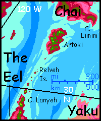
Though I discourage visiting, Suanla's mentioned for two reasons. Kuin to Cape Nag to Suanla to Cape Tempa is the best route (of a bad lot, I admit) from Chai to its southern neighbors Yaku and Az. You shouldn't peel off to the south, but lots of your Capsican comrades do. Not a world-class flyway, but a major regional one.
Suanla is also a further example of a non-obvious corona. While these Venusian geo-blisters do of course vary in size, Suanla is quite typical--a rough oval 400 km long (250 mi). Look again at the map. All those western islands and capes like bubbles in a mudpot... Compare to Suanla and the capes of northern Yaku beyond it! I suspect this too is a (perhaps embryonic) corona field.
But don't go exploring it. A hard hot voyage, and dangerous even if you make it to Yaku. The Tempa Peninsula does have high, wooded hills, but they're even hotter than Suanla's, and inland from Tempa are more desert flats nastier than Ogon. Alkali, dust, rocks at boiling point. Try it and the Burning Man may be you.
SOUTH CHAI
Past the Kuin Hills, the Ogon mellows... grudgingly. Slowly the brown flats redden, or at least pinken. This coast, the Infish Plain, gets some rain in an irregular, whimsical summer monsoon. Agriculture's unreliable except along the mountain-fed rivers, but it's a fertile grassland. At this point, early in the building of Capsica, we can't say if those herds of grazers on Infish Savanna are wild animals, tame herds, or people who just like eating grass. In any case, we're back in settled country. From Baluchistan to the Indus Valley! Well, sort of. It's still hell for Terrans--even now in winter it's 60°C down there (140°F). Worse than Karachi!
Stick to the high road, ride the winds. That monotonous Capsican chorus... but good advice.
THE LABYRINTHS
Around the third day, we pass unnoticed the great narrows where the mountains become an isthmus between two plateaus, the Tai to the west and the Aksora to the east. Though no doubt once a continuous strip of highland, the Sindra River relentlessly gnawed into the plateau from the north, creating a dissected basin of mesas and sky islands, green-capped, red-floored, a day's flight wide: the Grand Canyon of the Sindra. It's more reminiscent of Noctis Labyrinthus on Mars than any Earth canyonlands: hundreds of km wide, over 1000 long, and 2-3.7 km deep (6,600-12,000'!)
But we ride on, oblivious; we can't tell that we're now skirting the Aksora Plateau. On day six, though, the Kolati Range ends abruptly, dropping off into a hazy abyss of mesas and winding canyons. For here the Aksora Highland is bored into by a similar canyon-complex opening to the south, right in our path: the Shato Labyrinth. Though it's not as extensive as the Sindra Labyrinth, Shato is just as deep--two Grand Canyons and more.
So here, looking into the Shato Labyrinth, you face a dilemma--follow its convoluted edge north and hope to find a way round, or attempt to cross? I think we'll try to cross it. Conditions down in the canyon are deadly, of course, even now in early spring--45°C or more (113°F) at least--but the mesa tops are so much higher they're probably survivable, and updrafts will be spotty but strong. Follow me! We spiral like hawks, then dash across chasms, hopping from meas to temple to sky island... A day or two of hot, tricky, but exciting flight, and outrageous scenery. The labyrinth is lurid--the basalt strata are rust to black, the softer layers between are lighter but pitted with shady arches and caves, blue in the haze; veins of vegetation follow streams and cliff-feet, green, red and purple depending on altitude and season. White streams leap off the flanks of the Kolati Range and the plateau beyond, into the gulfs...
These canyons aren't rare on Capsica, and their great depth is neither chance nor my own hunger to impress you with showy scenery. They're inevitable. Seas here are shallow--most of Capsica's vigorous relief is exposed to weathering, unlike many of Earth's great escarpments buried under miles of sea. In particular, more basaltic plateaus are exposed--legacies of great eruptions that bury softer strata. On Earth continental platforms are 3-4 km, aided by the fact that underwater features are sheltered and supported by the water; on dry Venus, they reach 3 km or so. On Capsica, with its lower gravity, they often reach 4 km even though they face weathering. In dry regions, especially ones with summer thunderstorms (and Chai's southwest coast is perfect!) rivers eating into basalt capping softer strata can gnaw out great canyons and labyrinths. The low gravity allows cliff walls 3-4 km high to survive. None rival Mars's Mariner complex, with its 6-kilometer scarps--even if a river could carve such a valley, the sea would flood it--but dozens of Capsican labyrinths double the Grand Canyon in every dimension.
SOUTHEAST CHAI
Across the mouth of the Shato Labyrinth are the Renka Mts, a long east-west range. Snowless, of course, here in the south, despite its Himalayan heights (peaks reach 6-8 km, 20-26,000'). Again we ride the winds on their southern slopes, so you can't see that the Renkas differ from the Kolatis: to the north is broken country now--ridges and near-desert basins. We've left the high heart of Chai; the Renkas are a spur.
Two days east, we face a choice. A spur of lesser mountains, merely Alpine in size (if Floridian in climate), shoot off to the southeast: the spine of the Ichu Peninsula.
This is very different country from the southern deserts and savannas we've seen to the west--Ichu is warm and wet even by Capsican standards. Inhospitable to Terrans at any season--too hot. At most we could explore the higher hills of the Peninsula's spine--the Kuorm Hills. At 2-3 km up in winter, the Kuorms feel like sea-level jungles on Earth's equator. On a hot day. It doesn't look hot, though; the heights squeeze moisture from the sea winds, veiling the hills in streamers of warm mist. Terran eyes can't but see these gray skies as cool, even as your naked skin feels that damp sauna heat.
The forest canopy here is a garden, a sort of flowering land-reef 50-100 meters above the dim, undersea ground. Ruby, magenta, maroon, plum, with banks of flowers in white, gold, blue. Enjoy the scenery, but don't linger. Fungi and molds here are just itching to colonize your skin. And your body heat won't discourage them as it does back home. Here it takes a bit more than that! Capsicans have core temperatures averaging 70°C (158°F) for good reason. To the critters of Ichu, you're a cold-blooded corpse begging to be, uh, recycled.
Really, the only reason for you to risk coming here is if you're one of those extreme tourists intent on circumnavigating Capsica or exploring its hot spots--by crossing the channel from Chai to Kifura, the scorching tropical continent to the southeast. I'm still writing that tour--Kifura has a mountainous spine, but even in orbital winter those hills are dangerously hot for Terrans; I'm still struggling to figure out how I can guide tourists down its length and keep them alive.
Before you get too blotchy, let's go somewhere drier. Glide northwest again, back to that junction in the sky with the Renka Mountains. As we head inland and rise above most of the clouds, the hills grow steadily cooler and drier until it's just a hot day in quite Terran tropical forest at the foot of the high Renkas. You feel as if you've emerged from reefs to the shore of a craggy Polynesian island, and in a way it's true. If Capsica had seas like Earth's, this would be Cape Renka, the southeastern tip of Chai. In a way, it is--the southeast tip of the Chai that Terrans can survive on.
Follow the Renkas east again, another full day. You'll know when to stop. The Renkas, like the Kolatis before them, end abruptly in a great river canyon. Below you swims a gulf of humid heat. But there's no Himalayan range on the far side of the gulf--just modest hills whose peaks flirt with the green line. Ridges wear olive and bronze caps, blends of red and green trees, with flanks of pure flame. The gulf is shadowy purple in the sunset, but looks patchy--meadows and groves.
You know these hills--or will in the morning. Sleep if you can. It's only 35°C (95°F).
In the clear dawn light, look north. Trace that silver snake of a river up the plains. Pink savanna with bloody veins, vast herds of grazers... like a African themepark gone psychedelic. To the south, the trees close in, a nappy red rug, broken only by silver loops as the snake curves west toward the sea.
Look familiar now? That's the Long River, escaping the bounds of the Coast Range we started in. We set out months back from that very hill--for so it seems, now that you've seen peaks quadruple that height.
We've come full circle around Chai, riding the wheel of the winds.
And by now, you may be starting to understand how Capsicans see their world--at once bigger and smaller than our groundhog view of Earth. Bigger because they travel by windpower and musclepower, mile by mile--and smaller, because Capsican fliers, whatever their form, have a godlike overview of their land. All within 100 km is local, an hour's journey; a day's hard flying takes you far beyond that big horizon. The loop around Chai we just took months to complete, some 13,000 km (8000 mi), may seem to us as heroic as the travels of Marco Polo or Ibn Batutta... but to a Capsican, it's a lazy little vacation.

World Dream Bank homepage - Art gallery - New stuff - Introductory sampler, best dreams, best art - On dreamwork - Books
Indexes: Subject - Author - Date - Names - Places - Art media/styles
Titles: A - B - C - D - E - F - G - H - IJ - KL - M - NO - PQ - R - Sa-Sk - Sl-Sz - T - UV - WXYZ
Email: wdreamb@yahoo.com - Catalog of art, books, CDs - Behind the Curtain: FAQs, bio, site map - Kindred sites