Capsica's homepage, map, giant ref map, geography, gazetteer . More worlds? Planetocopia!
 Capsica: the Southeast Crunch
by Chris Wayan, 2010-2022
This one's dedicated to Covid-19 for
giving us so much time home alone
Capsica: the Southeast Crunch
by Chris Wayan, 2010-2022
This one's dedicated to Covid-19 for
giving us so much time home alone
Introduction - Botany - Zoology - Touring - South - West - SE - Central - NW - North
The Crunch is mostly arid. Island arcs and high plateaus cut off its central basins from the Spiral Sea and the intense rains it generates. Seas are small, separate, salty, and ebb and swell seasonally, leaving salt flats and barrens where the temperature can climb to 90°C (194°F). Inhospitable even to the locals, and promptly fatal to careless tourists.
But the southeast and east rim are coastal, hence relatively rainy. Here the lowlands are a great savanna cupping a chain of stable, freshwater lakes, larger than anything on Earth. For here alone in the Crunch, the rivers reach the sea.
Intro - Botany - Zoology - Touring - South - West - SE - Central - NW - North
Most Capsican vegetation is reddish or purplish and uses a light-capturing molecule we'll call rhodophyll. It's adapted to a temperature range of 30-80°C (86-177°F). These rhodophores predominate in the lowlands and low latitudes; in highlands and near the poles the only plants that flourish are green, using "chlorophyll" (well, a very similar squarish molecule using a magnesium atom that absorbs reddish light but reflects green; what else can I call it?)
Ecologically, a second tier of strange-colored, cold-adapted plants should be no surprise. Remember our own cold-adapted evergreens with their dark bluish needles and antifreeze. Infrared satellite photos show ordinary vegetation as bright red, but evergreen forests as black. Capsica's palette just happens to show a similar clash in visible light--plum to purple in hot zones (fading to lavender grasslands in dry regions), and quite Earthlike greens in cold wet zones and golds in cold dry regions. On most of the planet, that kind of cold is found only high up. The Antarctic coast is about the only place on Capsica where green plants march down to the sea.
Intro - Botany - Zoology - Touring - South - West - SE - Central - NW - North
Though Capsica's poles and high mountains seem balmy to us, animal life here evolved in scorching lowlands, with enzymes to match. The Capsican word for exothermic is just like colloquial English: "cold-blooded". But they mean blood that merely matches the environment; on average, hotter than human! The key word here is "average". Just as on Earth, such creatures are sluggish and generally less sophisticated, for all but the largest must endure what for us would be severe chills and fevers. Not friendly conditions for running a high-end brain!
Endothermic or "warm-blooded" here means what on Earth we'd have to call hot-blooded: typical body temperatures are around 70° C/158°F. Over most of Capsica, this causes no problems, but here in the polar regions, and especially in the uplands, animals must insulate heavily or die. But it takes a lot of food to grow fat and fur and to sustain ovenlike temperatures inside. Even so, this is evolutionarily easier than retooling a million enzymes--Capsican hot-blooded life is too well adapted for the vast rhodophyll zone.
Worse yet, in the highlands, the air thins to only 1.2-1.8 atmospheres--as low as half the pressure at sea level. Flight becomes harder; large animals (and upland beasties are--it helps conserve heat) must settle for an bizarre, clumsy, energy-hungry strategy called "walking". Or they don't settle at all; diversity plummets in the highlands, and no large fliers at all live here. We'd see these uplands as quite Terran, with green woods and fields, hot summers, mild winters--snow rare to never. Not bad. But to native Capsicans they're as harsh as Siberia... plus Tibetan thin air.
Intro - Botany - Zoology - Touring - South - West - SE - Central - NW - North
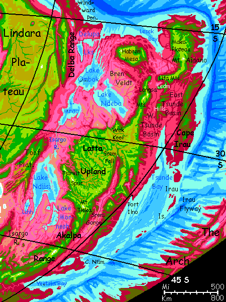
The southeast and east edges of The Crunch are one of the few parts that offworlders can tour with any safety. The basins are fatally hot, but there are extensive highlands. I plan to start in in the late fall in the south, and meander north along the mountains, peering down into the lowlands--quite diverse, sharing only fatal heat. Eventually, at the north end, we can exit to the Arch, near the Canal Zone; not an easy sea-crossing, but there really is no other practical exit for Terrans. If you were a heat-tolerant local, of course, you'd have many more flyways to take.
Intro - Botany - Zoology - Touring - South - West - SE - Central - NW - North
We'll start in the Akalpa Mountains above Lake Ntim. The Akalpas are much like our Himalayas, just not as ice-sculpted. Peaks up to 8 km (well over 26,000'), with passes over 5 km (near 17,000') leading to plains around 4 km up (13,000'). These mountains aren't the highest on Capsica, but some of the coldest. Winter snowpacks on the peaks can be substantial, with temperatures below freezing for days on end. Few glaciers--mostly at the south end. Even Himalayan heights thaw out every summer. Subpolar not polar.
Standing out even among the Akalpas is a horn unlike the others--it seems to have been sculpted by ice, and there are actual streaks of white on its high shoulders--Sei Peak, 8.4 km high (27,600').
We glide north, on the east or windward face of the Akalpas, where updrafts make flight effortless.
To the east/right, the lower Srem Valley--magenta orchards and lilac pastures mark lowlands with a plenty of rain and a mild climate for this high latitude. Both are due to the Spiral Sea, raising humidity and damping temperature swings; those farms rarely get below 35° or above 60°C (95-140°F).
To the left, a parade of peaks; but whenever we go by a pass, you can see 200 km to the west--though it's just a pink dusty haze down there, really--dry savanna. Not much of a tour! Well, on the second day you glimpse a shiny mirage on the heat-shimmering horizon.
Only it's no mirage. That's Lake Mornesh.
Oh, let's get suicidal. It's winter, a high latitude, and a continental climate west of the moutnains--as cold as we're likely to get on this trip. Today it's just 25°C up here on the Akalpas (77°F). Go ahead--jump off that cliff and skim down the slopes. Endlessly down, over green forest, then open olive woods, then scattered red trees in lilac grasslands, then the pale pink of dry rhodophore grasses and even patches of open rock. A couple of hours later, it's 40°C (104°F), but a turquoise cove's ahead--one of many on the ragged east shore of Lake Mornesh, the smallest (just 400 km long never more than 160 wide (250 by 100 mi)--not much larger than Lake Erie), and the highest-latitude, and the only lowland lake we'll be able to visit.
Dive right in--the water's warm. I mean, blood warm! But by getting wet then evaporating dry then hopping in again, you can stay hot but safe here--for a short visit. Dive around the rocky heads, baffle some fish (they've never seen anything as weird as you).
But eternal vigilance is the price of survival here, for Terrans. Sleeping here? Not a good idea.
Let's use the thermal difference between land and water--find a rising column over a rock pile and ride it up til it's a little cooler, and head back toward the Akalpas and a viable camp.
I just wanted to show you it can be done, occasionally, when conditions are right. And for most of us, only immersion makes a thing real.
North another long day to Mt Tleka, 8 km high (26,300'); a near-twin to Sei, and still patchy with snow, but with no visible glaciers--7° closer to the equator (39 not Sei's 46). Like flying from Mont Blanc to southern Italy. And we're just getting started.
Intro - Botany - Zoology - Touring - South - The West - SE - Central - NW - North
West a long day on Serret Spur, the raised southwest rim of Latta Plateau; this ridge repeatedly hits 5.5 km high (18,000'). The shady south face often gets winter snow though of course it all melts by mid-spring. Green forested slopes with ferny and grassy summits. We'll camp on green Serret Prow, a wedge jutting out from the plateau, two miles above the savanna north, south, and west.
At dawn, from this viewpoint, Lake Ndiisi is a blue sea on the horizon--and though freshwater, it's a true sea for it's nearly as big as our Caspian. You can even see one of the Kadelim Islands, a freshwater chain running roughly parallel to the east shore for 500 km (300 mi)--nothing on Earth compares. Dive down to see? But Ndiisi's a bit lower and closer to the equator than Mornesh. It's 45°C down there (113°F) already. By afternoon it'll be hotter. I'm just not taking you into that.
Next day we head northeast in the morning, along the rim. Lunch at Khiba Falls--nothing like those delicate thread-falls, creeks plummeting off Serret Spur, but the full Khiba River leaping over 300 meters (1000') into a striated gorge. Below, white rapids snake through tumbled red-forested hills, down to the veldt and the inland sea.
To the north, a mountain wall--Tsirvit Spur, parallel to Serret but longer and taller, up to 6.7 km (22,000'). A few such peaks bear streaks of snow from the last storm to whirl through. This wall is not something you can cross in rented wings with your weak muscles and solid bones. We'll have to go round.
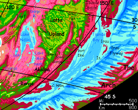
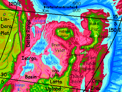
Head northwest along the plateau rim. Stick with it. All day. Hundreds of km, out to Tsirvit Head, another promontory above... the same damn lake! Ndiisi again. I warned you it was no mere Terran 'great lake'. It's bigger than all our Great Lakes put together. Though you're near the outflow now. In fact that gleam to the northwest isn't another arm of Ndiisi--that's Lake Isargo, the pipsqueak of the chain, only 160 km long (100 mi), a Lake Champlain lost among the Greats...
From Tsirvit Head our northwesterly course swings round at last. As you round the end of the Spur, the land to the north drops savagely away. Green castles--isolated mesas the size of cities--rise from hazy gulfs. Red veins in the depths mark streams falling off the plateau. Welcome to Ksit Labyrinth, nearly 3 km deep.
Ksit is not unique on Capsica, indeed, rather small compared to, say, Sindra and Shato Canyons in central Chai, both deeper yet. This isn't chance, nor my own hunger to impress you with showy scenery. They're inevitable. Seas here are shallow--most of Capsica's vigorous relief is exposed to weathering, unlike many of Earth's great escarpments buried under miles of sea. In particular, more basaltic plateaus are exposed--legacies of great eruptions that bury softer strata. On Earth continental platforms are 3-4 km, aided by the fact that underwater features are sheltered and supported by the water; on dry Venus, they reach 3 km or so. On Capsica, with its lower gravity, they often reach 4 km even though they face weathering. In dry regions, especially ones with summer thunderstorms (and the inland Crunch is perfect!) rivers eating into basalt capping softer strata can gnaw out great canyons and labyrinths. The low gravity allows cliff walls 3-4 km high to survive. None rival Mars's Mariner complex, with its 6-kilometer scarps--even if a river could carve such a valley, the sea would flood it--but dozens of Capsican labyrinths double the Grand Canyon in every dimension.
So here, looking into Ksit Labyrinth, you face a dilemma--follow its convoluted edge east and hope to find a way round, or attempt to cross? I think we'll try to cross it. Conditions down in the canyon are deadly, of course, even now in winter--40-45�C (104-113�F)--but the mesa tops are so much higher they're probably survivable, and updrafts will be spotty but strong. Follow me!
We spiral like hawks, then dash across chasms, hopping from meas to temple to sky island... A day or two of hot, tricky, but exciting flight, and outrageous scenery. The labyrinth is lurid--the basalt strata are rust to black, the softer layers between are lighter but pitted with shady arches and caves, blue in the haze; veins of vegetation follow streams and cliff-feet, green, red and purple depending on altitude and season. White streams leap off the flanks of Latta Plateau, into the gulfs...
Next a relatively smooth stretch of rim, with "coastal hills" at most, no more than 5 km high (16,500'). We glide north a few days, slowly curving round to northeast.
The savanna below seems more rumpled and the color shifts from a pale pink to lilac--like the shift from yellowish dry grass to green. We're entering the tropics and nearing the sea; this land gets more rain.
No lakes, though. They're out there--one, anyway, Lake Mrau, about the size of our Lake Huron. But it's 320 km away, beyond even the long horizon from our high vantage. Just lilac waves and a few dusty-rose snakes where creeks off the Plateau seek the unseen sea.
A day due east. Sheer cliffs 3 km high (10,000'), but as this bit of plateau has a raised rim, only small feathery falls--and these unlucky creeks plunge into sandy, soil cut off by ridge from the Isargo Basin. These spidery washes converge on a small brackish lake. You can tell it's salt from here--a pale turquoise eye rimmed with scabby white.
Much of this mini-basin is just tawny sand and dun rock--like a model of what lies deeper in the Crunch, on a horrific scale. One of the key lessons of Capsica is that bad drainage is far worse than mere heat.
At last a final promontory--a big one, jutting many miles out into the abyss: Wek Keel. A green cleaver rising 3.7 km (12,000') from a lavender sea.
Capsica's strange.
Camp at the tip of Wek Keel. As the sun sets, a pool of redsilver fire reflects it: Lake Ndeba, yet another giant of the Isargo Basin.
At dawn you're surprised to see two gleams of open water: to the west-northwest Lake Ndeba, and to the northeast... Ndeba again! 200 km apart (125 mi), they're different lobes of a single lake triple the size of Lake Michigan.
Intro - Botany - Zoology - Touring - South - West - The Southeast - Central - NW - North
South from Wek Keel into the Latta hinterland. Over a low pass green with ferns and lichens--too windy for trees. We're 4.6 km up (15,100'). You have to work hard--plenty of oxygen, indeed more than Earth, but the air's thin under your wings, and instead of the strong updrafts common on the rim, just a capricious crosswind out of the east that keeps shoving you off course.
Down the far side. You camp in green woods by a creek with a lovely swimming hole at 3.8 km (12,500'). This could be Earth in summer--it's 30°C (86°F). Except on Earth, this sandy stretch would be full of swimmers. But no Capsican comes up here when it's so hideously cold...
Next morning, thunderclouds ahead. With steady thunder. It's the head of Srem Gorge, with its great fall; the Srem leaps 400 meters (1/4 mile) in one green arc. So much spray it forms a standing cloud. Here on the wetter side of Latta Plateau, rivers have muscle. The Upper Srem Basin's no bigger than the Khiba River catchment was... but it gets twice the rain.
Southeast along the western wall--the prevailing winds hit it and rise, giving you a free ride all afternoon... Our goal's actually on the east side, but let's use this while we can. Next day, south again. The gorge widens to 120 km or so (70 mi).
Camp where the canyon bends due south. Rest up.
Cross to the east wall. Here's the trick: wait til late morning when the west wall's heated and the updrafts can lift you miles high. Then cross as the sun shifts and starts heating the east wall. When you reach it, you'll need that altitude boost.
Through the tangle of ridges and spires along the east rim, northeast...
At dawn, a puddle of molten gold on the eastern horizon: the sea! Paling to silver, then blue as the sun climbs and you near.
I had hopes of letting you tour an actual Capsican town. The highlands loom right above Port Ilno; two vertical miles and two horizontal! Like a cluster of cubist mushrooms growing out of the red lowland forest, a jumble of blue tile roofs and houses painted yellow and green cling to slopes and cliffs round the head of Ilno Bay. You can see wagons and people in the streets--well, bright cloaks hopping around--for them, it's a cold wave, and everyone's bundled up. It's deep winter, we're 37° south on an east coast; about the same latitude and setup as Tokyo, Seoul, or Washington DC, which do face freezes or near-freezes most winters; as Capsica's 35°C (63°F) hotter on average, I hoped for a 35-40°C day (95-104°F).
Almost got it, too; it's 45°C (104-113°F). And humid; the wind's off the sea. We just can't visit. Maddening.
But then all Capsica's like that. You can see local life from afar, but you're shut out.
Sigh!
Intro - Botany - Zoology - Touring - Touring - South - West - SE - Central - NW - North
North along the west wall of the Ilno Valley. Spectacular cliffs here, up to 1600 m high; taller than Half Dome, and sustained for miles. The winter winds off the sea slam head-on into The Wall (as it's imaginatively called). You just have to dodge the occasional squall of warm rain. The weak cold snap's faded; it's now unusually mild down on the valley floor: 55°C on the valley floor (131°F). I chose the west wall not just for scenery but because it's higher and cooler--no more then 40, and often 35 (104-95°F). You cool off in creeks but have to pick swimming holes carefully; strong currents as they prepare to launch off the Wall into the steaming abyss.
Two days north... the flyway slowly creeps inland. The Ilno Valley comes to a head. White water below.
An odd stretch now--deep east-west valleys cut into the highland, ridges. As rugged as any Alpine horns and cols, but not ice-carved; here a fracture zone from the distant Rift crosses the Spiral Sea and gnaws at Latta Upland's rim. Hours up, hours down, up down up down. Luckily for your shoulders, you don't have to flap to gain altitude like a migrating crane; plenty of rising air, as the prevailing winds here rush upstream. Clouds tatter around you.
Two days later, the pattern shifts back to north-south ranges; green heights to your left, red rumpled lowlands to your right--orchards to the horizon. Clear air. The Tsunde Basin.
The climate down in the Basin, being maritime, is much milder than inland; the temperature doesn't swing as much. The locals like that; but for you that's actually a bad thing. Yes, summer heatwaves on the shores of Lake Ndeba can climb into the high 70s°C (c.170°F), compared with just the 60s on the coast (140s°F); but either will kill you just as dead. And winter cold made it possible to swim in Mornesh, while it's almost 50°C (and humid!) down in West Tsunde--around 120°F.
Really, we have no choice but to stick to the uplands from now on--winter or not, we've been creeping toward the equator.
West Tsunde. The Ledm Hills, the East Tsunde basin, the Irau Mts. Let's not go and say we did--rich country, but it's a dead end for us. Not, of course, for the Capsicans, who can fly down the Irau Peninsula and its island chain--a classic island arc--all the way to G'lasa. Or, more commonly, cross the Spiral Sea to the southeast Arch. You're steady enough on the wing now to follow them across those straits, but those low-lying isles of the Irau Flyway are are just too hot for you, even in winter. 2000 km with nowhere to rest.
So let's head north along a sinuous ridge--the Langsa Mountains, 4-5 km high (13-16,000')--and they need to be; we're nearing the tropics.
Lowlands to the east AND west now--but what a contrast. African savanna (if pink instead of tawny) on the left, this green meandering mountain wall where you ride the winds, and the cloud-dappled red orchards of Tsunde on your right. But over the next three days, the veldt blushes redder. Maroon groves, lavender grasslands. Red hills rise. Langsa Ridge remains high and strong to the end, but storms are starting to get round its tip, ahead.
The sudden end of Langsa.
No apparent way forward. More skylands do rise out of the thermal sea, but beyond your horizon.
Take this next flight on trust.
Intro - Botany - Zoology - Touring - South - West - SE - Central - The Northwest - North
Scattered cloudy-wrapped mesas rising a km or two out of jumbled red-forested hills. Most are below the green zone; olive at best. 2.4-3.6 km up (8-12,000'). Hot damp camp. Rain. Beautiful, though; like a Roraima with half the trees spray-painted magenta, the rest left green.
Next day, a chain of mesas like Greek temples--topped in olive woods, columned cliff walls--hexagonal basalt columns. Just hundreds of times taller than the Acropolis. Island rising not from a turquoise Mediterranean sea, but a deep ruby jungle.
At last, the islands end in a... mainland. Huge Habren Mesa, an oval plateau sprawling 400 km (250 mi). White falls leap off the cliffs, looking delicate until you near and hear the roar.
Along the south rim around to the southwest corner. An olive promontory thrusts another 25 km southwest (15 mi). A mile down, the ridge continues, lower and broken, snaking southwest, carpeted in shaggy red rainforest. This divide, too low and hot for you to follow, winds on for hundreds of km; it's a sill dividing Lake Ndeba from Lake Ombok--otherwise they'd be the largest freshwater sea in the world. But all their vast basins, and Lakes Mrau and Delupa too, are forbidden you. Low and deadly hot, even in winter.
Look west. Here at the farthest point you can safely go, you experience what must be an optical illusion--that those low ridges go on forever, dozens of them, all right across your view--north-south valleys, each a few miles apart.
It's no illusion. The Ombok Waves, they're called. In the Arch, near the rift valley and its spreading zone, such washboard country is common; but here in the Crunch, it's relatively rare--most of that compression gets swallowed by trenches, like monster shock absorbers. But here the land's just crumpled. Lake Ombok has iceless fjords created by these fracture-ridges, though from here they're lost in haze, 200 km away.
Head north up the west side of Habren Mesa a day. Easy flight, easy camping. It better be--it's humid as well as hot, making even these heights uncomfortable.
East a day, riding updrafts along the rim, trying not to exert.
Over the mouth of Habren Canyon, where most of the mesa's runoff collects and drains to the Spiral Sea.
Southeast half a day across a wide gap to an olive mesa. Don't push; camp, rest, sit in a creek, stay as cool as you can.
At dawn, head into the sun--or where you know it to be. Enough puffy clouds so you can mostly stay in the shade while it's low.
Intro - Botany - Zoology - Touring - South - West - SE - Central - NW - The North -
The Lita Mountains. Well, mountains from their south side; precipitous cliffs on the north. Waterfalls, then Lesek Veldt--a patchwork quilt of lavender meadows and blood-red groves, not the denser monsoon woods you saw to the west. It's a bit rainshadowed by Mako Plateau and Habren Mesa.
East, then north, up the curving Litas toward Mako Plateau.
Ahead, a hulking giant--Mount Aidano. An extruded mass of pinnacles and buttresses looking strange to Terran eyes--it just doesn't seem right for a Himalayan-scale peak not to be ice-sculpted. Looks unfinished. You camp on the shoulder at 5 km, the peak still another 4 above you (the summit's almost exactly 9 km or 30,000' tall). Relief! Above much of the cloud layer, less muggy... and no warmer than a Hawaii vacation.
Yes, that's snow up there--just as on the Big Island in winter. Not much, but some. Even if it won't last long.
Out to Blunt Point. The Mako Strait Flyway over the Spiral Sea to The Arch, not too far south of the Canal Zone. A crowded flyway--understandably. It's just 200 km wide, coast to coast--the easiest crossing in 4-5000 km. Though for tourists it's over 250 (150 mi), for you have to fly highland to highland. Fortunately those do exist on both sides. The Arch tends to be rugged.

World Dream Bank homepage - Art gallery - New stuff - Introductory sampler, best dreams, best art - On dreamwork - Books
Indexes: Subject - Author - Date - Names - Places - Art media/styles
Titles: A - B - C - D - E - F - G - H - IJ - KL - M - NO - PQ - R - Sa-Sk - Sl-Sz - T - UV - WXYZ
Email: wdreamb@yahoo.com - Catalog of art, books, CDs - Behind the Curtain: FAQs, bio, site map - Kindred sites