Capsica's homepage, map, giant ref map, geography, gazetteer . More worlds? Planetocopia!
 Capsica: The Eel
by Chris Wayan, 2011
This one's for you readers, who pestered me until I had to build it
Capsica: The Eel
by Chris Wayan, 2011
This one's for you readers, who pestered me until I had to build it
Introduction - Intro - Touring - North - Middle - South - Prath Pen. - Out
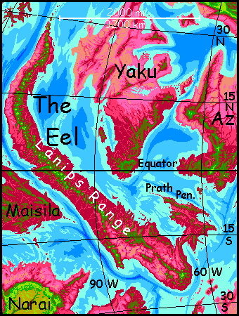
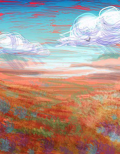
If this small, wriggly continent were moved to Earth, it wouldn't be a continent--just a chain of small volcanic islands. Only because the seas here on Capsica are so shallow does much of this platelet rise above water at all.
For Terrans, the Eel really is an island chain--specks of Terran climate atop the central mountains, rising out of an uninhabitable sea of oven-hot air.
Unlike Yaku and Az, the small continents to the northeast, the Eel does have high mountains that reach into the chlorophyll zone, even at the equator. Essentially the Eel is a long volcanic range paralleling an offshore trench, like our Andes--just with much more modest lowlands to the east.
The Eel sprawls across the equator; its lowlands, wet or dry, summer or winter, are hot even for native Capsicans, and fatal to Terrans: averaging 60°C (140°F) and up to 70°C (158°F). Luckily the Eel has a bumpy spine: a chain of steep stratovolcanoes worthy of the Andes (and then some! Many are 6 km (20,000') but a dozen or more top 8 km (26,000') and one is 9.5 km (31,000'). In orbital winter even the equatorial peaks of the Lanips Range are cool enough for... snow? Don't make me laugh. Cool enough for Earth tourists to survive. Comfortably. Naked.
That means the natives find them uncomfortable--even dangerously cold. Yet you'll meet Capsicans on these peaks, bundled up and shivering. Fellow tourists there for the spectacular views, yes, but also business travelers. Why are they up here? They're riding the updrafts generated by the mountains. For much of its length, the Lanips Range stands across the path of the prevailing winds. Most Capsicans fly; the Eel is, for them, a natural bridge between southern and northern hemispheres, and a very convenient one, avoiding the equatorial heat.
But reaching those cooler heights, and traveling in them, is not easy for tourists who didn't evolve for flight. For this trip you'll need oversized strap-on wings with at least 50% more wing area than the already clumsy, underpowered wings you've learned to use on other Capsican tours. These are even harder to maneuver in, and take a couple of weeks' hard training to use at all; you're grossly underpowered for their wing area. But these condor-wings have the virtue, if you can master them, of raising your flight ceiling from about 3 kilometers (10,000') to 5 kilometers (16,500'), where the air thins to just 1.4 Earth atmospheres (of course on poor high-grav Earth they'd be unusable at any height). And at that altitude, the heat is... bearable.
Intro - Touring - Northern Eel - Middle - South - Prath Pen. - Out
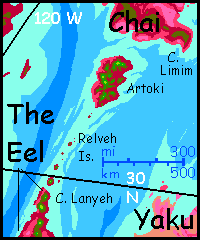
Terran travelers from the north will reach the Eel with sore shoulders, and not just because you're not quite broken in to those damn condorwings (no, you don't break them in; they break you). To reach the Eel, it's a nightmarishly long hot flight in from western Chai. It starts well enough: the high peaks on the great isle of Artoki are cool islands in the sky, but south of Artoki there's only a chain of low atolls, the Relveh Islands, stiflingly hot for Terrans, even if you spiral down at dusk and climb again before dawn.
At least the mainland Eel offers relief--eventually. Not the coast of Cape Lanyeh--under that cool-looking flock of puffy cumulus clouds hides a plum-colored monsoon forest. It's 50-60°C (122-140°F) down there, and evaporative cooling schemes won't help you; summers aren't just oven-hot but humid, as the forest transpires. Keep your altitude and chug on despite the pain. Cape Lanyeh's central hills hump steadily higher until their heads turn olive and then green... sky-islands of merely Earth-tropical heat.
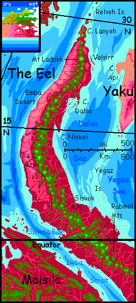
A day ahead--and visible most of that day, muscling up through the cloud-flock--stands a real monster call Mt Ladokk by the people of its eastern jungles, or Laduak by the people of its dry western slopes 100 km away. Heap five or six Kilimanjaros and Denalis together and you might get this scarred dormant cone 9.5 km high (over 31,000'). Far more impressive than Everest, since Laduak rises from near sea level and is twice as tall from hoary head to red rumpled toes; even draining the Pacific to reveal Mauna Kea's full height wouldn't really match Ladokk, since Hawaiian shield volcanos have gentle slopes while Laduak is a stratovolcano steeper than Fuji. Now, in winter, ephemeral snow caps the summit, and high on the north face in a shady col is this continent's only glacier--well, persistent snowpatch, at least. It's a place of summer pilgrimage for the locals, who view it with delight mixed with almost-superstitious terror. Almost, but not: their fear's quite realistic! A Capsican merely touching that evil white stuff will sustain burns. How could life-giving water turn to such a deadly poison?
In the treetop cafes around Laduak's feet, you'll hear bittersweet breakup songs exploiting that image over and over. Gets tiresome. Does every civilization in the galaxy have to sing about love gone bad?
But poison can be profitable. If you want to make some quick cash (and really impress your hosts), eat some snow on a bet. It's safe enough. Many Terran bacteria thrive in snow, but very few Capsican ones--any more than Terran life's adapted to lava.
Still, the summertime gaggle of Capsicans having snowbunny fits won't be there now--brrr! And it's quite a hike to see that snowpatch. Hike? Sure. You certainly can't fly up to the summit. Waist-high on Ladokk, the air's already thinned to your ceiling for powered flight. But don't give up--skirt the mountainflank to the east. That's the upwind side, and you should be able to ride those updrafts quite a bit higher, to 5.5 or 6 km (18-20,000'). The top's just another 3-4 km (10-13,000') straight up! Go ahead. I'll wait for you. The view's nice enough here on the shoulder, thanks.
Is there a law in physics about the conservation of irony? For the Capsicans who can fly up to the summit, the snows are deadly; for you, it's the easily accessible gulfs below Ladokk's beltline that are deadly.
But though the lowlands to the left and right are equally fatal, even from up here you can see they're quite different. The east coast looks much like the northern tip of the Eel--rich red cloud-dappled forest with muggy summers and wet winters. But the west coast is downwind, and the sheer height of the Eel's spine wrings much of the rain from its winds; so to your right the herd of cloud-sheep thins to a few strays. Pink, brown and lavender savanna hills and plains with ruby stream-veins stretch 250 km to the horizon. On Earth it'd be even further, but Capsica curves more sharply.
Next morning quite a few locals head east, zooming down Ladokk's slope like crazy ravens into the rising sun. They'll rest and have lunch on Velsirr, a barrier island about 15 km out, only 3-5 km wide but over 80 long (2-3 by 50 mi). Then they'll head east out over the shallow sea. Barring severe storms--always a possibility in Capsica's lowlands, even now in the relative calmer of winter--in a few hours they should reach Cape Api on the desert continent of Yaku.
Don't even think about it. Cape Api is a flat patch of dry savanna hitting 70°C at high noon--158°F for you Americans. And that's the maritime coastal climate--inland Yaku gets hotter. Stick with the Eel!
You ride the winds south, resting on volcano-tops every few hours. Along this stretch of the Lanips Range few are more than waist-high to Laduak--4 to 6 km (13-20,000'). You can often hawk-soar right to their summits. Volcano-hopping like steppingstones across a creek. Five volcanoes later, around noon, a spur heads southeast. All afternoon, through cloud-gaps on the horizon you get glimpses of a cape and long ruby islands sheltering a wide sound: Dalso Bay.
No clouds off to the right! It's true desert now, and will remain so for a couple of days--browns and golds you so rarely on rose-tinged Capsica: the Emba Desert. As in our Sonora Desert, prevailing winds are weak and blow down from the mountains, rain-starving that naked coast. Mere fogs from offshore; no storms. The cloudless Emba plains often reach 80°C (177°F) in the shade, and of course there isn't any; on some afternoons, the rocks pass boiling point.
On the next day, nothing much changes; volcano after volcano, jungle under pink-shadowed clouds to your left, broken only by another spur forming Cape Niskei, smothered in cloud; the cloudless golden silence of the Emba wastes to your right. The chain of the Lanips swings due south and rises: above a jumble of merely Alpine peaks rise proud steep cones 6-8 km tall (20-26,000'): the Ba Range. From head to toe every one is taller than any mountain on Earth.
We follow Newton's advice, and snore on the shoulders of giants.
Intro - Touring - North - The Middle - South - Prath Pen. - Out
The next day, the Ba Range curves southeast, and the abyss to your right starts changing from golden desert to a healthier pink savanna. White clouds and lavender cloud-shadows scuttle across the plains, fugitive strays at first, but soon in herds over every hill and ridge. Lone pioneering trees spread out from the streamsides to speckle the savanna. The mountains split and grow lower; two parallel chains soon march down the spine.
The next morning, the central mountain-valley has come to a head and the ranges reunited. On the right, the desert is gone--magenta groves spring up in lavender meadows like psychedelic leopard spots, thickening until it's the meadows that stand out as paler bare spots in crimson plush. Not that you can see much--by the time the woods dominate, the clouds have closed in. You've reached the equatorial zone. Here, both east and west coasts are clouded in much of the time and endure daily showers--or hourly drenchings. But this stretch of the Lanips rises higher again, in a tight knot of peaks above the cloud-sea: the Siskok Range. Looking down into that sea, the gaps are deep plum-color. Down there in the sauna, it's lush stormforest. The year-round heat creates rising air, steadily pulling in rainclouds off the constantly evaporating seas.
Sorry--even those don't cool the lowlands enough for a visit. Rains range from pleasantly hot showers to scalding downpours. Avoiding the rains won't help: air temperatures are a steady, relentless 60°C (140°F). Stick to the mountains' survivable chill.
South of the Siskoks is a hundred-mile gap. Not coincidentally, the clouds ease a little--these saturated tropical winds condense into cloud mainly when they're forced up by hills. To the west, a brief gap opens. A silver flash! For the first time in days, the western sea's swung in close enough to see. That's Sivlepa Bay, a side-arm of Ileba Strait, the narrowest point between the Eel and eastern Maisila, a huge equatorial subcontinent to the west. Maisila's bigger than all of the Eel, but can't be called a continent because it's a mere lobe of that nameless landmass that girdles Capsica and includes most of the land on the planet, including the Arch and the Crunch. Some things are too big to see.
Some of your Capsican acquaintances wheel and dive down the Sivlepa Valley toward Maisila, but you shouldn't follow. It's a major flyway because Ileba Strait is narrowest here, but the hills on both sides are low and miserably hot for Terrans. Patience!
Luckily, across the Sivlepa Gap from the Siskoks rises an even higher cluster of nearly Himalayan peaks, the Rabmol Group. Well above the storms... and heat. But even the Rabmols never see snow--they straddle the equator and are still a mile lower than Mt Laduak.
Here quite a few Capsicans join us, riding the updrafts out of the jungles to the northeast; the Yegaz Islands form a flyway from the desert continent of Yaku due north of us, and its twin Az beyond. Low, small, dryish, furnace-hot, for Terrans the Yegaz islets would be (almost literal) hell. They're hard even for locals; drinking water's scarce on the northern islets, though they grow steadily rainier as you near the Eel's equatorial stormforests. Again, patience... I'm trying hard to find you livable routes.
The next day, we wind southeast through passes 3-4 km high (10-13,000') between snowless peaks twice that and more. The following day, the Rabmols slowly wane to a single sedate line of Shastas, Ararats and Fujis. This stretch of the Lanips runs roughly parallel to the winds, so you must spiral high up the windward face of each great peak, then glide and flap across a fifty-mile abyss (tiring work with these oversize condorwings built for soaring) to the next giant. You're an experienced condor by now, you can do it--but it doubles your mileage and halves our pace.
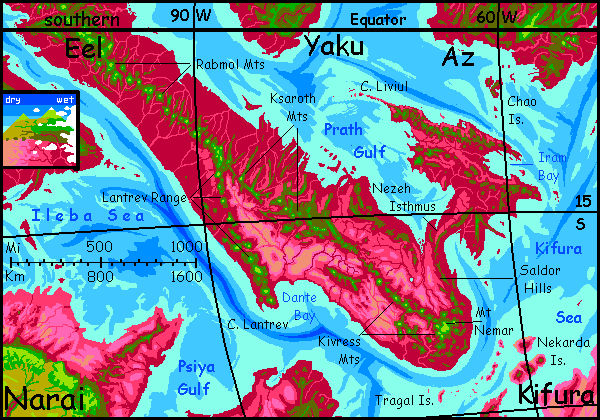
Late that second day, the central range forks. Here you have choices to make. The higher fork, the Lantrev Range, heads due south--but it's a spur leading out to Cape Lantrev and out of the Eel entirely, southwest to Narai, the next quasi-continental lobe south from Maisila. The Lantrev route is recommended for more heat-sensitive travelers as the next stretch of the Eel gets hot. While central Narai is still just 30° south, its uplands are so high they're quite comfortably Terran.
Despite appearances, the lower spur to the southeast, the Ksaroth Range, is the Eel's true backbone. But volcano-building falters briefly here, as the spine's tectonic energy splits between the Lantrev and Ksaroth spurs; there's only so much magma to go around, you know! Budgeting's important.
Still, the trench that built the Eel is vigorous, and by next day, the mountains recover from doing double duty; a wide cluster of green Rainiers and Denalis climb proudly above a tangle of lesser ridges: the Ksaroths proper.
But these mega-Fujis no longer rise from a ruby jungle. To the south and west the red forest grows patchy and pales to lavender, pink, rust and even browns as the day passes. We're entering the latitude for a second coastal desert, this time south of the equator--like Peru's Atacama.
Ahead, things get dangerous. The Eel has widened as we near its head. Storms attenuate fast here as they roll inland. There's a coastal range now, too, to the northeast; tropical storms regularly batter those ridges, but only the shreds and dregs water these inland basins and foothills. That's still enough rain for scattered woods, at first, but the land to the left gets steadily paler, bonier, harsher. To the right, it's true desert now, brown and gold: the appropriately named Dante Valley. Mountain streams from the Ksaroth Range and the Lantrev Spur meet to form the Dante River, 1200 km long (750 mi)--sort of a Nile in miniature. Its bottomlands are fertile, though searingly hot for Terrans.
Even our flyway soon grows unsafe. We're south of the equator, where the seasons are reversed. I started you out in early spring in the north--still quite cool, and in the north orbital winter (when Capsica swings furthest from its sun) reinforces axial winter (the north tilts away from the sun). In the south, all seasons are milder because axial summer coincides with orbital winter, still in effect no matter which side of the equator we're flapping around... What this means is that it's a coolish autumn here in the south, but still distinctly warmer than in the north. So we need higher peaks to sleep on. Back then, 3-4 km (10-13,000') would do in a pinch; here we need 5 or more (16-17,000').
And just when we need the Andes, they're failing us. This stretch of the Lanips sags again, and flights grow long between the few peaks high enough for us to camp on. We can't see the cause from here: the Prath Peninsula, a wedge of corrugated, splintered crust bigger than Spain. A sort of tectonic shock absorber, this compression feature eases the pressure on this stretch of mainland Eel. The offshore trench is just as deep but continental creep is slower. Half-speed collision!
The result of all this is that we must island-hop over a shimmering sea of deadly heat... and the death-tide is rising. Instead of cloudforested summits, these volcano-tops have sparse caps of spindly pine. Drinking water becomes chancy... mere trickles in high canyons and meadows.
Fortunately, by next day the first of a chain of much higher peaks creep over the shrunken horizon: the Kivress Mountains. This is the true head of the Eel, and we're headed for the eye or brain. By noon you can see it on the horizon: Mt Nemar, a messy cluster of volcanic vents topping out at 8.8 km (29,000'--Everest's twin!) The top is truly Terran: the air's as thin as Earth's at 1.5 km (almost a mile up), and now, in winter, the summit may even get snow flurries (remember, we're 24° south now;). It's not quite Mt Laduak, but again you can't possibly fly up there; even Capsica's low gravity plus dense air plus your oversized wings plus updrafts can't lift you that high.
But the locals have an annual race up the mountain. Sorry, you missed it. You had to. It was a month or two back in late summer, when it's safe and warm. In winter or spring, a contestant might crash into a snowpatch or encounter a hailstorm, and instantly frostburn. Fat chance, really--but Capsicans are phobic about the stuff.
But you're lean and tough now, after 5000 km on the wing, and ride the updrafts with almost native skill up to our camp at fully 6 km (20,000') on the great mountain's shoulder. Even that is cool: 20°C (68°F), and even cooler at night.
Intro - Touring - North - Middle - South - Prath Peninsula - Out
If you're finding you've adapted a bit too well to Capsica, and room temperature now gives you chills, have I got a side trip for you! Follow me north. For two days we head up a dangerously low and narrow coastal range, the Saldor Mountains, camping on the few peaks with (barely) endurable temperatures (40-45°C/104-113°F). I promised you toasty. No goose bumps ahead, either!
Late on the second day, the Saldors' main ridge gives a nervous twist to the right, and suddenly there's sea on both sides, turquoise and slate under the puffy clouds. A couple of hours along Nezeh Isthmus, the land suddenly widens, especially to the right. We've reached Prath Peninsula, nearly the size of France. It's shaped like a spiny dorsal fin or vestigial wing on the Eel's overall dragon-shape. Prath is a strange fractured wedge of land where (as far as I can tell) the trench creating the Eel frays into parallel faults and slippage-zones.
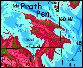
Prath's geology is modeled after a real place--the lowest part of the Tharp Fracture Zone, a wedge of seafloor 5 km down, southwest of Tahiti and east of New Zealand. Indeed much of this hemisphere--a maze of low rises and miniplates and wandering mountain chains--is modeled after structures under our Western Pacific. If they seem arbitrary and senseless, amateurish planet-building, please direct your complaints to your favorite Terran benthic deity--Cousteau, Poseidon, Sylvia Earle, Maui, Sedna, Ariel, we're equal-opportunity here. Whoever wiggles your eel.
If you don't find Prath's geography convincing, or even sane--don't worry. You can't see much of it anyway. Prath's much closer to the equator than the southern Eel, and the cloudbelt is denser.
That means more rain, too. Microclimates vary in Prath--woodsy around Iram Bay and out on Cape Liviul, but even in the inland valleys, the forest opens only to lilac savannas; nothing like the sere ochre deserts of the southern Eel.
The crazy fractal coasts are scenic, rather Greek perhaps, all sounds and capes, but here in the tropics even the highest peaks--all under 3 km--barely rise into the olive zone; few are cool enough even in orbital winter to be green--or to be bearable long-term base camps for Terrans, unless you're a masochist desert rat. If you're determined to explore, the Liviul Range along the north coast is your best bet. But just find a high peak and rest up; don't follow the Liviuls hopefully out to their end. Unlike so many Capsican peninsulas linking continents, Cape Liviul just trails off in mid-sea, hundreds of kilometers short of Yaku--and if you survived the crossing, you'd have to slog another 1-200 km inland to reach the Mashmelao Hills--and they're no higher or cooler than the Liviuls.
But northern Prath is a portal: if you can endure one steady, miserable day of flight due north over the sea, resisting the temptation to land and rest halfway in the Chao Islands (which look lush and shady, but those ruby trees should warn you it's fatally hot for you) you can reach the much higher and cooler Timun Mountains of southern Az, full of water, fruit and shade. From there, after a merely tropical vacation, you can proceed (with luck and stamina) to the cooler, more Terran lands to the north.
Touring - North - Middle - South - Prath Pen. - Out of the Mouths of Eels
The only other semi-safe route for tourists camping on the high shoulder of Mt Nemar is to camp out on the peak a few weeks as the weather cools toward early winter, then head southeast. The Kivress Mountains shrink quickly though, down to olive Alpine peaks, then ruby Appalachian ridges that plummet straight into the sea. Keep going--and prepare for a long haul. This is a wider strait than most. There's a curving trench a couple of hours offshore; it probably caused the high volcanoes behind us. Push on! We have to cross that trench to have any hope of reaching high ground again.
Why should we expect land at all? Isn't this the lower plate, being pushed under the Eel? Well, yes, but even on Earth, the subducting side of a trench often has modest rises and lesser volcano-chains (check out the seaward edges of the Philippine Plate and the back side of the Mariana Trench); it isn't as simple as those plate-tectonic diagrams would have you think. Earth's ocean masks a lot.
Soon an arc of low, garnet-red islets appears: the Tragals. Far too hot for us; I've guided you wrong and gotten you killed, I guess. Game over!
But Capsica isn't Earth. With Capsica's shallow seas and low gravity, "modest" rises can save your life. A second line of islands, the Nekardas, creeps over the horizon, this time volcanic cones--one smoking! We'll camp on the highest, and rest a few days on its hot, humid, rainforested summit (3.7 km up, or 12,000'). Once rested we'll hop south over a much narrower strait to the long bloody jawbone of Cape Nekarda and the huge continent of Kifura.
You've done it--escaped the mouth of the Eel. Flown its length. One of the more difficult tours, I must say.
Ugh. Just occurred to me. If we escaped via the Eel's jaws, what did we enter?

World Dream Bank homepage - Art gallery - New stuff - Introductory sampler, best dreams, best art - On dreamwork - Books
Indexes: Subject - Author - Date - Names - Places - Art media/styles
Titles: A - B - C - D - E - F - G - H - IJ - KL - M - NO - PQ - R - Sa-Sk - Sl-Sz - T - UV - WXYZ
Email: wdreamb@yahoo.com - Catalog of art, books, CDs - Behind the Curtain: FAQs, bio, site map - Kindred sites