Capsica's homepage, map, giant ref map, geography, gazetteer . More worlds? Planetocopia!
 Capsica: Ekurre Volcanoes
by Chris Wayan, 2012
Outline only! Under construction!
Capsica: Ekurre Volcanoes
by Chris Wayan, 2012
Outline only! Under construction!
INTRODUCTION
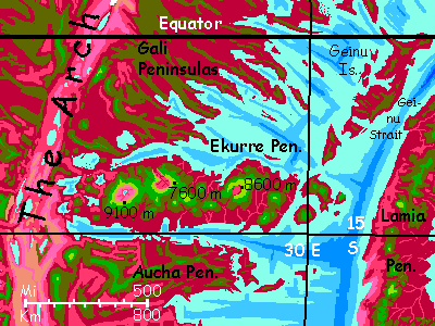
This chain of shield volcanoes rises in the huge, rugged rift zone called the Arch, not far south of the equator. It's less massive than our Hawai'ian chain, but only because the chain isn't as long. The volcanoes are just as high; Mt Ekurre itself rises nearly 9100 m (30,000') and its lava flows spread several hundred km. Two others in the chain also reach Himalayan heights.
The seas here on Capsica are so shallow that the Ekurre chain hasn't formed islands like Hawai'i; they've fused into a rugged peninsula. The weight of these massive outflows has bowed down the crust around the range. Hawai'i, just as massive, has done the same, but invisibly, on the abyssal floor; but round the Ekurres, long sounds and lakes mark this sagging oval moat.
If the hot spot creating it is so vigorous, why's the Ekurre chain so short? Is it recent? Can we deduce what causes such hot spots by looking at the tail end of the line, as an examination of Hawai'i's tail reveals changes in plate motion over 100,000,000 years back?
Well... no. The tail is gone--swallowed by a trench to the east, part of the ring of subduction around the bizarre conglomeration of The Crunch. Ekurre's plate, though moving at about the same pace as Hawai'i's, just isn't very wide: only about 2500 km from spreading-zone to trench, from birth to death. The hot spot has been building volcanoes for much longer than 75 million years, but that's all that we can see--the earlier ones have been gobbled up. These volcanoes get recycled!
TOURING
The Ekurre Range parallels the equator, 10-15° south of it; its lowlands, wet or dry, summer or winter, are hot even for native Capsicans, and fatal to Terrans: averaging 60°C (140°F) and up to 70°C (158°F). They'd be hotter yet if they weren't so humid; clouds often cover them, except in the west and in the rainshadows of the great peaks (west or northwest face).
Though snowless, these heights are climatic islands in the sea of red. The high meadows of the outer slopes, above 5 km (16,400'), thrust up through the cloud-sea into relatively sunny air. But these heights aren't arid, as on many Terran tropical peaks. Capsica's denser atmosphere, thinning slower in the lower gravity, means high-altitude air can hold much more moisture than Earth's; and Capsica's tropics have more thunderstorms, especially in global summer, when the little planet swings close to the sun. The heights are still dry enough to discourage trees--the higher peaks have quite Terran-looking meadows, turning gold in the winter dry season, greening again with the summer rains. Only on the northwest slopes of the Big Three, downwind of Himalayan heights, does this "alpine" savanna fray, baring the black and red lava flows beneath. Baby Tibets.
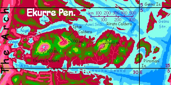
The Big Three all have wide calderas like Kilauea but far bigger; more Martian or Venusian in scale, with cliffs up to 4 km high (over 13,000'), though mostly half that. Their floors are islands of savanna or Mediterranean groves, much sunnier (when not shadowed by those huge cliffs) than the lowland rainforests. Though ecological islands, these aren't Lost Worlds cut off from the outside. The relentless tropical rains eventually eroded and breached the walls.
With one exception: Ekurre itself, too big, too young, too vigorous to have breached yet. Ekurre Caldera is still its own world, a county-sized savanna draining to a slightly brackish but drinkable central lake. The floor, 4-5 km up, is sunny and sheltered; hence warmer than you'd expect for that altitude. So the flora is mixed red and green--about the highest place rhodophores grow on Capsica.
The air's dense enough to fly in, too, and those sunny cliffs generate strong updrafts; native fliers will have no trouble spiraling up to the rim. So the fauna won't be unique. Cliffs just aren't effective prisons on a world where most animal life can fly. But you, with your solid bones and underpowered muscles... you aren't likely to make it out, not in your rented wings. Even to reach the low point of the rim, at 7000 m (23,000') will require a hike. You can breathe Capsican air at that altitude, but not fly in it!
So hike in, peer down from the rim, take your pictures, but don't give in to temptation. I know someone will get the bright idea of packing in their strap-on wings and diving over the edge. Don't. Stick to Rirato and Iptak Calderas for that game; they're as big as you can handle, and they have exits.
Not Ekurre. You can swoop in, but you can't soar out. Roach Motel for tourists!
JUST PASSIN' THROUGH
Half those offworlders you've seen on the lower slopes, clumsily flapping around in their strap-on wings, aren't here for scenery. The Ekurre Peninsula and its halo of islands are the only practical non-polar crossing of the Spiral Sea from the Arch to the Crunch--the two largest landmasses on Capsica. Though it's a hot, hard flight even in orbital winter, it is possible for Terrans.
Head east along Mt Rirato's eastern ridge, cross that steaming red rainforested plain (like a big bowl of borshch) to the coastal hills--well, hills next to the Big Three, but you camp 3.8 km up (12,500') in a green forest that could be Amazonia on a hot night. Next morning you flap across the narrow strait to the Piromani Isles. Don't worry about flying east into sun-glare. Plenty of clouds, even now in the (relatively) dry season. These rugged islands force the air up until cloud-caps form. You could camp here in comfort--at 4300 meters (14,000') it's a mere 35°C (95°F) but we still have half a day of light. Bank north over the cloud-dotted sea--turquoise in the sun, indigo in the shadows. Well before sunset, clouds ahead mount into tumbling thunderheads over the hills of the southernmost of the Geinu Islands, a rugged chain of long isles with twisting ridges, looking a bit like the Philippines, if your eyes saw infrared. Ridgetops here are lower and hotter--you camp and rest, but it's midnight before it drops below 40°C (104°). A sweaty miserable night followed by a sweaty miserable day. You ride thermals up into clouds to get some relief and head steadily north. Another bad camp on Great Geinu, at 3200 meters (10,500'); a little cooler but still rough.
Well before dawn, you get up and start the crossing--to Cape Amoc on the Lamia Peninsula, nearest arm of the Crunch. Geinu Strait's 200 km (125 mi) wide, but from green height to green height, it's more like 250 (150 mi)--several hours with no rest possible. Even if you can crash-land on land, you'll steam to death down there.
But with luck you'll make it to the Crunch--a weird land full of cut-off sunken seas and harsh deserts, but also some of the highest mountains on Capsica--often jammed up side by side. Prepare yourself! The Crunch makes the Ekurre volcanoes look almost like home.

World Dream Bank homepage - Art gallery - New stuff - Introductory sampler, best dreams, best art - On dreamwork - Books
Indexes: Subject - Author - Date - Names - Places - Art media/styles
Titles: A - B - C - D - E - F - G - H - IJ - KL - M - NO - PQ - R - Sa-Sk - Sl-Sz - T - UV - WXYZ
Email: wdreamb@yahoo.com - Catalog of art, books, CDs - Behind the Curtain: FAQs, bio, site map - Kindred sites