Capsica's homepage, map, giant ref map, geography, gazetteer . More worlds? Planetocopia!
 Capsica: Fulisse Peninsula
by Chris Wayan, 2016
Capsica: Fulisse Peninsula
by Chris Wayan, 2016
Introduction - West Fulisse - Central Fulisse - East Fulisse - Tabaska Is.
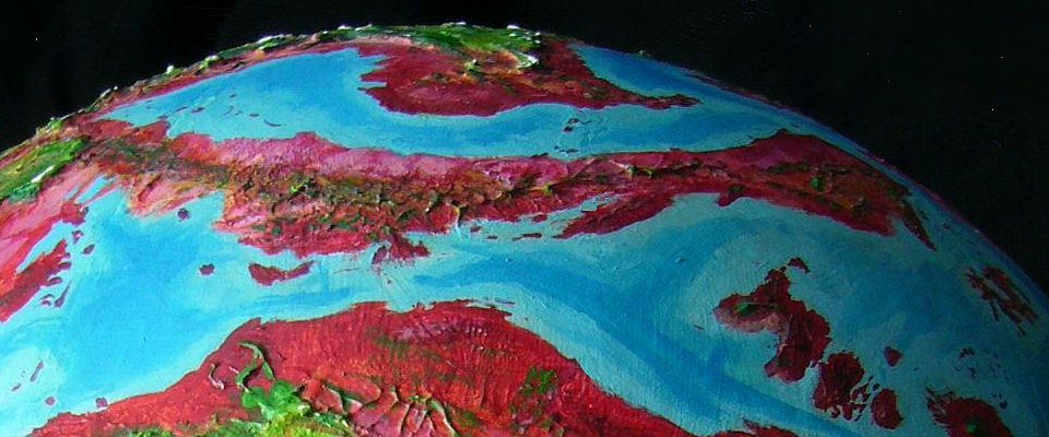
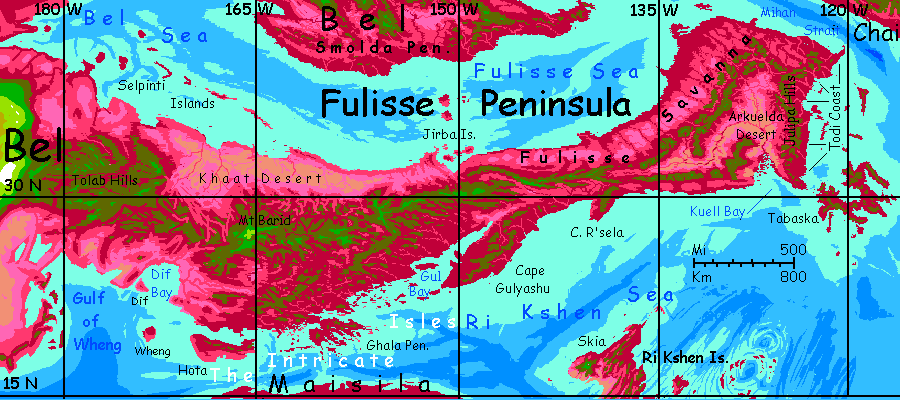
Fulisse is a huge peninsula thrusting east from the continent of Bel. It's over 4500 km (2800 mi) long and up to 1000 km (625 mi) wide. Since Fulisse is around 30° north and has rather modest mountains, nearly all of it is too hot for Terrans. The central spine of the peninsula does have some ridgetops tolerable in winter. As these mountains also generate updrafts, they're the main flyway through the region; you'll be following these ridges the length of Fulisse. At this latitude winds generally blow eastward, so we'll tour from the base of Fulisse out to its tip, riding the wind all the way.
Even though this will be a winter trip in the mountains, don't bother packing a sweater. Or any clothes, really. You won't want them. In deep winter, temperatures on the heights in Fulisse may drop as low as 30-40°C (86-104°F). If we're lucky.
Introduction - West Fulisse - Central Fulisse - East Fulisse - Tabaska Is.
Western Fulisse Peninsula, where it roots in the many-lobed continent of Bel, is more fertile overall--the peninsula curves, and this end is at a higher, rainier latitude than the central section. Also, the mountainous spine is higher here on average, snagging more rain. Open woods in the lowlands--red groves, lavender meadows--and olive (mixed red and green species) on the slopes of the Tolab Hills. Some summits and ridgetops top 3.4 km high (11,200'), and have predominantly green woods. Almost Terran.
The Tolab complex is huge--some 1300 km long (800 mi). You ride updrafts above those long wooded ridges for days.
At last you reach the narrows defining the end of West Fulisse and the start of Central Fulisse. It's quite noticeable even here, far inland. The mountains shrink to hills, the forest to groves and scattered trees; the heat, always present, goes from summery to oppressive. To the north, the lowlands open from patchy woods to lilac-colored savanna, scorchingly hot, with red watercourse veins--the fringes of the Khaat Desert. To the south, the flats turn even drier; not the lavender of thermophilic grasses but the orange and dun of sand and bare rock in places. But on the horizon, a silver glare--the head of Dif Bay. This semicircular gulf 250 km wide bites deep into Fulisse, dividing the western base from...
Introduction - West Fulisse - Central Fulisse - East Fulisse - Tabaska Is.
Less consistent heights than in the far west; some nights you can't find peaks high enough to cool off below 35°C (95°F). And of course days are hotter.
Inconsistent heights, I said; but Mt Barid is the highest peak on the Fulisse Peninsula. Located in the west-central part of Fulisse's mountainous spine, volcanic Mt Barid is 4.8 km high (15,900'); only a handful of the Peninsula's other peaks are much above 3 km (10,000'). In summer the shoulders of Mt Barid are the only survivable refuge for Terrans in the whole region; even in winter, the only comfortable one. Barid's summit still rarely if ever sees snow--just not high enough. It's a real island of relief, though, and has fine views for hundreds of km in this relatively cloudless latitude, where a high pressure zone wards off storms much of the year.
The west-central lowlands along the coasts, both north and south, are arid--but differently so. The north shore is still the Khaat Desert, brick-red with sparse brush and bare dun rock. The south, even hotter and drier most of the year, gets a variable summer monsoon--random thunderstorms really. Much of the water's wasted--rains too brief and violent for the soil to absorb it all. Runoff and erosion. Still, the inland hills and many seasonal watercourses over the coastal flats have sparse open forest. Most seedlings die, but if one lives long enough to send a taproot a few meters down, there's little competition; such trees may live centuries.
Terrans must stick to the flyway. The peninsula narrows as it runs east, and the mountains narrow and sag to mere hills a couple of km high--and not much wider. At one point, a day east of the base of Cape Gulyashu, Fulisse grows narrow enough you can just see the sea-gleam on both horizons at once--Gul Bay burning silver to the south, in the sun's glare, and pale blue Jirba Gulf to the north beyond pink and lavender savanna. Some Capsicans on the flyway peel off and head north--the Jirba Islands are a bridge to the Smolda Peninsula, a cooler, rainier lobe of Bel than any part of Fulisse. Don't follow them; the Jirbas are too low and hot for you.
Introduction - West Fulisse - Central Fulisse - East Fulisse - Tabaska Is.
Eastern Fulisse grows wider again, but the southern half is fertile only on the coast and the hills. Inland is the Arkuelda Desert, a triangular inland basin 5-800 km on a side. The two forks of the shallow Arkuelda River meet and run through the center, but most of its water evaporates before it reaches the sea at Kuell Gulf. Coastal mountains 1800 meters high (c. 6000') surround the basin, blocking storms in every direction except straight up from the south.
The north and east coasts of Fulisse's broad tip are fertile sea-level plains--the Todi Coast. On most of Capsica "sea level" automatically means "fatally hot", but because the tip of Fulisse bends north (up to 41°) it's the coolest lowland on the whole peninsula. That still isn't very. Todi's mild maritime climate never drops below 40°C or tops 60 (104-140°F). The land is mixed, diverse--meadows and groves where untended, pasture and orchards where the locals farm it. And many do. After the Intricate Isles it's the densest, richest part of the Peninsula.
Right now in the depth of winter it's barely over 40, so you may be tempted by the rare opportunity to see a deep ruby forest--truly enter the redzone and live. But it's humid heat. You can indeed survive it, briefly. But enjoy it?
The more sensible flight path is to ride the updrafts through the north-central hills, called the Julipas--they're a mile high, mixed red and green woods; cooler than the plains. Though a steambath minus five or ten degrees is still a steambath. I don't recommend them, but they're the only practical way to get out of Fulisse now that you've come this far. It's a long day's flight from the last hill northeast, over Todi's lowlands and the narrows, to Cape Mihan on the continent of Chai. It's a long flight inland to peaks in the Mihan Hills high enough for you, but they're better than the Julipas. And farther east on the Chai mainland, the Niet Range is Himalayan; quite Terran temperatures on their shoulders, and the high peaks (now in deep winter) even bear a little snow. Another world enitrely.
Introduction - West Fulisse - Central Fulisse - East Fulisse - Tabaska Isles
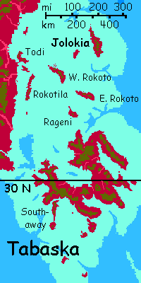
Off the Todi Coast are the Tabaska Isles. Capsicans consider them rich and lovely--a mild maritime climate, forests full of fruit, shallow bays with rich fisheries all around. The main island is well to the south of Fulisse so the climate's subtropical (by local standards; even in winter we'd find it a fatal steambath).
The Tabaskas are a natural rest-stop for native fliers between Fulisse and the small continent of The Eel. As a result, it's culturally rather cosmopolitan.
Tabaska proper, the Big Island, is 800 km long and 600 wide (500 by 375 mi). Dozens of volcanic cones dot the irregular island, rather than one giant as on nearby Skia or Kitto to the south, or a handful as on Artoki to the northwest. Possibly as a result of scattering the local geological vigor among so many volcanoes--really, there's only so much lava to go round--the tallest peaks are just 1-2 km high (3300-6600'). Red forest covers the fatally hot lowlands; olive (mixed) cloudforest smothers the merely sweltering heights. Winters often cool them to 35-40°C (95-104°F) but the humidity stays at 100%; fatal for Terrans, drippy and annoying for the locals. They farm and settle lower down, where you can get some sun (and see where you're flying).
The Big Island's satellites stretch a good 800 km north along the Todi Coast, but are just 5% of the archipelago's area. Still, four are larger than Oahu. Volcanic cones here too, but none are large; the highest peaks, on Jolokia, are just 1.5 km (5000'), and none of the Rokotos tops a single km. Scenic islands--"a nice place to visit but you wouldn't want to live there"? No, not even that. No thermal refuges at all! Unlivable even in winter.

World Dream Bank homepage - Art gallery - New stuff - Introductory sampler, best dreams, best art - On dreamwork - Books
Indexes: Subject - Author - Date - Names - Places - Art media/styles
Titles: A - B - C - D - E - F - G - H - IJ - KL - M - NO - PQ - R - Sa-Sk - Sl-Sz - T - UV - WXYZ
Email: wdreamb@yahoo.com - Catalog of art, books, CDs - Behind the Curtain: FAQs, bio, site map - Kindred sites