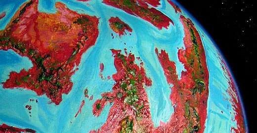
Capsica's homepage, map, giant ref map, geography, gazetteer . More worlds? Planetocopia!
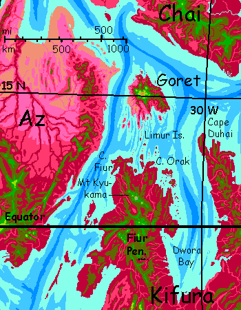
 Capsica: Isle of Goret
by Chris Wayan, 2012
Capsica: Isle of Goret
by Chris Wayan, 2012
INTRODUCTION
Capsicans consider Goret a lovely tropical isle--a warm maritime climate, forests full of fruit on the rainy side, open meadows for grazing on the sunny side, shallow bays with rich fisheries all around.
But the great factor shaping Goretian life and culture is not the Isle itself, but its location. Goret is a node where three intercontinental flyways meet--none major, but still, Goret gets travelers from all directions. Despite Capsica's backwardness in transport technology, Goret is cosmopolitan. Geologically it resembles Hawai'i, but culturally? The deeply isolated Hawai'ian chain was overlooked by humanity until a mere millennium ago and left isolated for centuries more. Goret was never alone: a nexus from day one. Wings made all the difference.
MT PRIKASH
Native Goretians stick to the coasts. The highlands are too high. Oh, they visit briefly for the scenery or for aerial sport--when you're winged, speed-diving down the long windward slope is at least as much fun as biking down Haleakala on Maui--but no sensible Capsican wants to live 9,000 meters up (29,500'). Those numbers are correct. Rising from a shallow sea, Goret's highest volcanic rim is taller than Everest! Still not quite tall as Hawai'i; Mauna Loa and Mauna Kea are 10-11 km head-to-foot (33-36,000'). But I mentioned Haleakala for a reason: Goret is almost exactly the same height as Maui minus ocean.
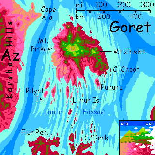
Mt Prikash is the highest peak on Goret--or rather, the high point on the summit-caldera rim. The great shield volcano's foothills are red, its knees olive, and its upper half green--when it's visible at all through the clouds it snags. Prikash is quite snowless--it's just 15° north.
Prikash has a caldera 25 km across (16 mi) and 2400 m deep (7900'). The floor is lakeless today; breached to the north long ago. If Goret were on Earth, Prikash's caldera rim would become a crescent-shaped mountainous island with great cliffs dropping into its azure central lagoon, like the Greek isle of Santorini times ten. Earth's seas are deep! Capsica's shallow seas, however, reveal the full breadth of this mass of overlapping shield volcanoes: 360 km across (225 mi).
Mt Zhelat, the second highest peak, is a volcano just over 6 km tall (20,000') whose flanks are steepened by erosion and dissection from heavy rains; Zhelat rises on the wet (northeast) side of the island. A chain of lesser vents extends far south to Cape Choot.
Though the highlands are Himalayan in height, they're not barren. Why? Four factors all conspire to give Capsican low-latitude highlands much more rain than Earth's:
Large animal life is sparse in the highlands, though. To Capsicans, with their ovenlike body temperatures, the year-round chill atop Prikash means you burn more energy grazing than you gain. At the poles, some animals have evolved massive insulation and adapted to cold-weather greenery loaded with strange enzymes operative at Terran temperatures; but the highlands of Prikash are recent, isolated and small. The wildlife is too. Maybe in another few million years.
So despite the greenery, the Isle Above (most of) the Clouds is home only to a few mystics and kooks. Most of the natives you meet will be fellow tourists, as foreign up here as you are. More so, thermally.
THE DESERT
There is true desert on Goret. Like Hawaii's, it's a rainshadow affair: the southwest coast is downwind from that Everest-sized summit. No rain comes from that direction! Creeks run down from the heights, carving canyons in lava rock. Except for streambanks it's harsh country--black and red.
Near the sea, where these creeks slow and meander, widening their canyons, irrigation is practical. Being fliers, Capsicans dig into the lava walls to create whole cliff-villages with balconies opening on air. Fine views, no need for ladders, and it's safer than living on canyon floors--they're prone to summer floods.
A ten-kilometer fringe of dry savanna surrounds the true desert--a borderzone of lavender grasses during the sparse rains of orbital, bleaching to a silver sea in the dry winds of winter. There will be creatures eating that grass--savannas can feed a lot of animals per square kilometer--but will the Capsicans be herders? or the herd?
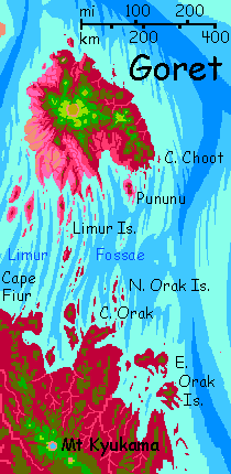
LIMUR FOSSAE
Mt Prikash's lava flows built up on a rather strange sea floor--shallow, with long strange north-south cracks running through the neighborhood, especially to the south. They run parallel to trenches to the east and west, hinting this is a small plate under strange pressures. The sea floor around Hawaii sags under the weight of the world's biggest mountain, but these parallel cracks, called fossae, suggest bulging and/or stretching under Goret. Mars has many fossae around the Tharsis Bulge, where its largest volcanoes cluster; Venus has several examples of smaller sinuous fossae quite reminiscent of Goret's, many near "sea level" too--like the Brynhild Fossae of Alpha, or the Perunitsa and Khosedem Fossae of eastern Phoebe, or the Oma Fossae of southern Hathor (okay, I used the same illustration for all of them...)
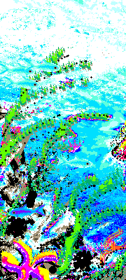
Terran mariners might have taken advantage of the fossae as safe ship-channels, but they wouldn't have seen the full extent of the pattern until they'd developed flight--or really good cartographers. Not so on Goret; the Limur Fossae are obvious to pilgrims on the wing--turquoise on purple and brown in the shallowest water, where Capsican equivalents of kelp forests flourish; azure on turquoise in slightly deeper water, where the cliffwalls of the fossae form spectacular rock gardens full of lurid-colored sea life (though not corals; most Capsican seas are too hot to hold much calcium in solution, so hot-water cousins of chitin and cartilage are the skeletons of choice.
I wouldn't dive here; these seas are hotter than you are! Hot enough to sting if not scald. Yes, you can probably adjust, but think about it. In a hot tub you don't exercise, fully immerse youreself, or stay too long; but half an hour in Tub Capsica and you'd collapse from fever. And thirst! "Water, water everywhere, and never a drop to drink." And salt depletion! You're sweating brine into hotter brine--not an effective cooling technique, but you didn't evolve for hot water, did you? (My apologies to extremophilic readers). One final blow to the head: Capsica's air pressure's so high you'd face nitrogen narcosis just 20 meters down. Rapture of the Shallows? No one of these factors will kill you on the spot, but combined they guarantee trouble will creep up on you.
So leave the lovely pseudocoral gardens to native Capsican divers. If you're feeling brave, take a ride in a glass-bottom boat under a canopy, draped in a wet blanket, stared at by Capsican grandmas and young parents with nurslings. Even that's so hot (45-50°C, 113-122°F) it's a challenge. Keep it brief. You don't belong down on the coast.
Or the islands. I forgot to mention--south of Goret the ridges between fossae sometimes rise above sea level, forming narrow islands with long cliffs: the Limur Archipelago. They're pleasant, scenic stopovers for tired fliers from Kifura. There's a similar patch to the west, the Rilyat Islands, much used by fliers from Az.
The beauty of the small and the local, you can get from travel snapshots. I'm after the implications of the broad pattern--a pattern I think Terrans would have missed. But not Capsicans. For generations these sinuous paths have guided fliers heading to or from Az and Cape Fiur. Though they still baffle local naturalists. As they baffle me.
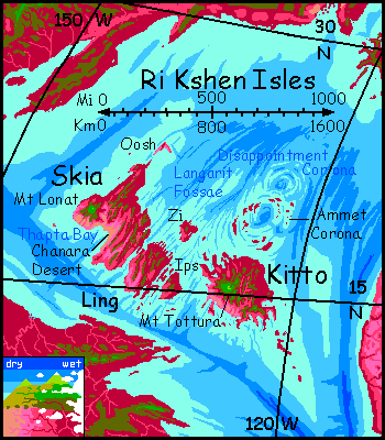
Whatever their cause, these fossae aren't unique. Halfway across the Outer Hemisphere, west of The Eel, is a platelet with a whole cluster of Gorets with fossae curving through them, even emerging on land in places: the Ri Kshen Isles. And there's a similar field in the Nipsak Basin, though it's desert land even less visitable than the Limur or the Langarit Fossae.
TOURING
This won't be much of a tour; not only is Goret small, most of it's too hot to explore. Only the central peaks are tolerable for Terran life. I'm racking my brain how to begin it, too; the great factor shaping Goretian life and culture is that the Isle is a node where three intercontinental flyways meet--none major, but still, Goret gets travelers from all directions. Earlier I contrasted Goret to Hawai'i, saying "wings make all the difference"--despite Capsica's backwardness in transport technology, Goret resembles modern Hawai'i more than the deeply isolated land overlooked by humanity until a mere millennium ago. That's true--for natives.
But Terrans can't easily share the experience. On many Planetocopian worlds you can do as the locals do--sail or fly along with them. It's possible on many of Capsica's regional tours--the gravity's low enough and the air dense enough--but the flyways heading into Goret are all long, hot endurance games even for the locals, who can start from the coasts and rest on low isles after a hundred kilometers or two. You can't: you'd be starting from higher, cooler land like the Karsha Hills on Az or the northern ramparts of the Kyukama Range on Cape Fiur. These are nonstop flights of 6-700 km--for you, sustained all-day torture sessions--at 40+°C (104+°F). Torture at best! More likely fatal.
I'm taking it for granted you don't want to introduce the Capsicans to alien technology and tour in a refrigerated tin can. The point of these tours is to get you out in the country. But on Goret, the approaches just won't co-operate. You might well make it. But then there's nowhere to go. Goret's culture is all down on the coast.
I know, I know--story of Capsica.

World Dream Bank homepage - Art gallery - New stuff - Introductory sampler, best dreams, best art - On dreamwork - Books
Indexes: Subject - Author - Date - Names - Places - Art media/styles
Titles: A - B - C - D - E - F - G - H - IJ - KL - M - NO - PQ - R - Sa-Sk - Sl-Sz - T - UV - WXYZ
Email: wdreamb@yahoo.com - Catalog of art, books, CDs - Behind the Curtain: FAQs, bio, site map - Kindred sites