Capsica's homepage, map, giant ref map, geography, gazetteer . More worlds? Planetocopia!
 Capsica:
Hi and Vepra
by Chris Wayan, 2011
Capsica:
Hi and Vepra
by Chris Wayan, 2011
INTRODUCTION
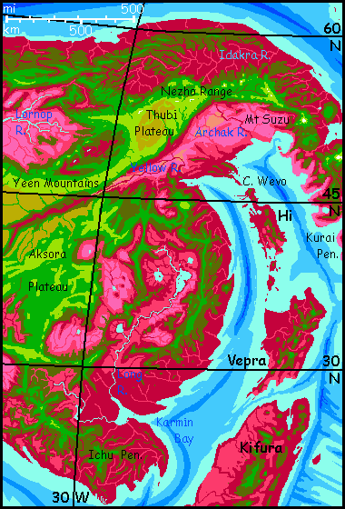
Hi ('Hee') and Vepra are large islands forming a flyway between the continents of Chai and Kifura. They resemble New Zealand in size, latitude, topography and fertility, with Hi as North Island and Vepra as bigger, more rugged South Island. The parallel has its limits; the vegetation is mostly bright red, and Hi and Vepra lie in the northern hemisphere, and are less equal in size: Hi is barely a third as big as Vepra. But the analogy's not bad. One other slight difference: summers routinely hit 60°C (140°F), easing to 35° (95°F) in winter. This is pretty mild for Capsica; the islands have a maritime climate. On the other hand, that means they're fairly humid, too. Not just heat but sticky heat.
So I think we'd better tour the islands at their coldest, in late winter.
Picture yourself on a boat on a river--no, wait, that's Lucy in the Sky with Diamonds. Picture yourself with no boat, just strap-on wings, with a seething sea beneath you and cliffs behind. You're riding the updraft as the sea breezes slam into the tip of Cape Wevo in eastern Chai.
This isn't Terran hang gliding--on Capsica you can manage true powered flight. Underpowered by local standards, but in this low gravity and high air pressure you can fly. It's the only way to get around, really--since most natives fly, there's little infrastructure of roads and ports. Why carve up the land when you have freeways in the air?
So be prepared for achy shoulders tonight. We're reaching Hi the way the locals do: by flying across the Hoba Sea. For them, it's only an hour of steady flapping; for you, maybe two.
You can't get lost--it's already visible to the south--that low line of purple hills with clouds tumbled and humped up over them like a pillow pile.
ON HI
A mere ninety sweaty minutes later--I underestimated you!--you're collapsing in relief under the trees back from a wide beach on the Waksa Peninsula, the northern tip of Hi. Hilly but low, Waksa resembles the region around Auckland on New Zealand's North Island. Hotter, of course, and redder. Everything is. Including you.
Once you've cooled off in the sea (okay, not cooled, it's blood-warm, but when you get out, evaporation counts for something) let's try wind-riding. The hills here are mostly north-south ridges, and the winds blow in from the east; east slopes are often updrafts. No need to hunt for invisible roads in the sky; just look for straggles of natives taking it easy. Do the same. You'll discover what hawks know: overland miles, at least in hilly country, are far easier than sea-miles, where there are few updrafts.
Though you ride above the bumpy spine of the peninsula, the sea's never out of sight. Waksa is one-third the length of Hi, but narrow, barely one-tenth its area. The sea's all turquoise shallows dotted with ruby (wooded) and lavender (grassy) islands.
You dodge round the east face of a hill over a kilometer high, and find more hills ahead, almost mountains--as tall as two km (6600'). Up here it's cooler, about 30° (86°F). An hour later, the sea backs off, east and west; you've reached the main body of Hi.
The locals find Hi quite pleasant; an Eden shaded under lush trees full of fruit, much like parts of our Southeast Asia. Well, a bit drier; Hi is in the fringes of a rainshadow, as it's downwind of the VERY tall mountains on the Kurai Peninsula to the northeast. Still, the east coast gets soft winter rains as well as summer thunderstorms. The west coast is a bit less damp and sticky, so let's veer right a bit and let the mountains catch the worst of today's east-coast drizzle.
We camp halfway down the island, a mile up the west shoulder of one of the higher ridges. It's cool and dry up here--a mere 25°C as night falls (77°F). The locals can't tell you if this Terran weather is normal here; no locals up here! They're all downslope, shivering indoors. This is the depth of winter.
The next day you head south and a bit east. We pass several unmistakable volcanic cones. Get used to them; they're even commoner on Vepra. Hi and Vepra ride atop a splintered little tectonic platelet between two trenches. It's less well-defined than Earth's clear island arcs, but analogous; these islands are under pressure from the Arch, a huge spreading zone to the southeast.
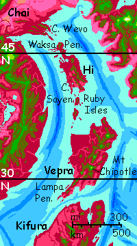
Around noon, we reach Sayen Bay, on the south shore of Hi. Sayen Head, 40 km long but just one or two wide (25 miles long, 1 wide) continues south from the west side of the bay. You won't need any prompting to head along it--the crosswinds hitting that ridge form a major (and very scenic) flyway south, and the sky over it has two lanes of huge fliers--a comet-chain of southbound pterodactyls, a caravan of northbound hippogriffs...
Follow that pterodactyl.
THE RUBY ISLANDERS
Out at the tip of Sayen Head, say goodbye to Hi. Follow the locals as they veer left toward the ruby isles on the southeast horizon. Which is their name: the Ruby Isles.
All day it's channel, island, channel, island. You camp on the beach of the southernmost Ruby.
What do the locals look like? We don't know any details yet, but a few generalizations are fair. They fly--the low gravity and dense air make that too easy to pass up. Maximum flight weight is at least 3-4 times Earth's. Since large brains fit best in creatures at the high end of that range, they'll be lean and graceful. Fat's too heavy to indulge in much. For insulation, they'll use feathers or fur--much lighter. I doubt they'll wear clothes either; it'd just tamp down their natural insulation and be a drag in the air. A seasonal coat is the way to stay light and unencumbered for flight.
"Why insulate in this heat?" you ask? But their body temperature is much higher--it has to be, so they don't roast inside in summer. Compared to their internal furnace-heat, Hi isn't sweltering at all, just a temperate island.
So regardless of species, we have a graceful, athletic, unclothed people in a warm, fruit-filled island paradise.
Polynesia?
Dear tourist, don't push that analogy too far...
UNDER THE CAPSICAN MOONS
One common fantasy about alien tourism won't happen on Capsica--or if it does, you'll regret it. Maybe you're thinking that a hot planet makes for hot people (true), and hot people make for hot sex. Capsicans and Terrans may indeed find each other mutually attractive--ah! the lure of the exotic!--and touching and brief embraces are possible. But in this case, Blake is wrong: the road of excess leads to the palace of ouch. Capsicans will be repelled by your corpse-like coldness; you won't be repelled, you'll be burned, and I don't mean emotionally. Perhaps a pair of thought-experiments are in order.
Sorry; it just won't work out. Alien nookie may be yours, on Serrana, Lyr, or Tharn... but Capsica? Yoooou'll beee sorrryyyy.
VEPRA
Vepra is nearly as big as Java or Cuba. And much hotter; we've been flying steadily south; Cape Wevo was halfway to the pole, but here we're at a latitude comparable to Cairo. It's damper then Hi, too: Vepra is far enough offshore to escape the rain-shadow of the Kurai Range. So Vepra gets consistent winter rains as well as a summer monsoon. The lowlands are a rich and uniform plum-red, the red of a healthy broadleaf forest. Not healthy for you, of course. I know you're tired, but stay high above that wood. Nowhere to land, and too hot to sleep in if you could. We need highlands!
Luckily, five of Vepra's many volcanoes are over 3 km (2 mi) high; the highest three reach 4-5 km (13,000-16,500'). They never see snow, even in deep winter. But their summits aren't just spectacular viewpoints but islands of Terran climate--what for us will seem lush subtropical forests. Let's head for the nearest. You can hardly miss it on the horizon--Mt Chili. A green one I guess, above this red-hot plain...
Chili's summit even has wind-blasted meadows amid the trees--it's not hard to land. Or crash, after that long passage. Get some rest. Peel down, rock in your hammock (no blankets, of course; it's nearly 35°C/95°F all night. Your skin will look like a waffle by dawn). Here, I'll serenade you with a romantic local ballad...
"On top of old Chili, all covered with cheese..."From here the flyway is clear. To the south is another green fang, cloud-wrapped but even taller: Mt Chipotle. Don't complain the names are unlikely. We're in the middle of the chain so you'll be spared Mts Galanga and Jinja to the north.
Sorry, all that flying worked up my appetite.
The next day we start early, attain the (relatively) cool summit of Mt Chipotle by noon, and rest up through the heat of the day. We'll need to. From here, the flyway leads south along the much lower and hotter spine of the Lampa Peninsula--the only respite will be the summit of 2-mile-high Mt Chatni. Then it gets worse: off Vepra, hopping through low steamy islands to the equatorial continent of Kifura.
But the Kifura route's not recommended for tourists unless you're dead-set on seeing Capsica's tropics. Emphasis on the "dead." Kifura does have a spine of high volcanic peaks much like Vepra, making it possible for Terrans in strap-on wings to travel Kifura end to end, with caution. But it's a grueling passage, even now in late winter--most days it's about 45°C (113°F). If you want to risk navigation by moonlight, you can fly by night--it may drop to a mere 35-40°C (95-104°F). Then you can sleep through the day-heat. Or try.
And don't get your hopes up about finding a nice cool cave to beat the day-heat: just as on Earth, most caves here have an even temperature close to the year-round day-and-night average for the region; but that average, at this latitude on Capsica, is 50°C (122°F). No escape undergound! You'd do better sitting in a creek all day, wrinkling like a prune... and even then...

World Dream Bank homepage - Art gallery - New stuff - Introductory sampler, best dreams, best art - On dreamwork - Books
Indexes: Subject - Author - Date - Names - Places - Art media/styles
Titles: A - B - C - D - E - F - G - H - IJ - KL - M - NO - PQ - R - Sa-Sk - Sl-Sz - T - UV - WXYZ
Email: wdreamb@yahoo.com - Catalog of art, books, CDs - Behind the Curtain: FAQs, bio, site map - Kindred sites