Capsica's homepage, map, giant ref map, geography, gazetteer . More worlds? Planetocopia!
 Capsica: Kifura
by Chris Wayan, 2011-12
UNDER CONSTRUCTION--south is mere outline.
Capsica: Kifura
by Chris Wayan, 2011-12
UNDER CONSTRUCTION--south is mere outline.
Introduction - Touring - North - Chekua Highlands - SE - South - SW - Deserts
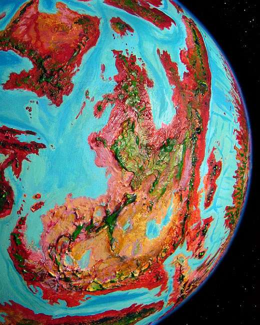
If Kifura were on Earth, it would be a chain of islands--one bigger than Borneo, plus several Javas, but nothing continental. Only because Capsica's seas are so shallow does this plate form a continent bigger than South America. Among Capsica's larger landmasses, Kifura has the lowest average altitude--only its little sisters to the west, Yaku and Az, are lower.
Kifura's latitude is also low--it straddles the equator. Altitude and latitude combine to make Kifura the second hottest place on Capsica--nearly as bad as the sunken desert basins of the Crunch. Summer highs in its central deserts can reach 85°C (185°F), though 75-80° is more common (167-177°F). Note that this is still far below boiling point! Capsica's dense air, more than double Earth's, keeps water liquid until 124°C (254°F). Sun-heated desert rock faces may hit boiling point (as they can even on Earth!), but not air temperature; certainly not ponds or creeks. Capsican seas are in no danger of boiling away.
Most Capsican lowlands are red or purple, covered by rhodophyll-bearing plants. Not these! Dusty pink to brown--sere grasslands and bare desert. There are exceptions: the equatorial north is a healthy red, and the southern coast sees winter rains, but the vast heartland is stark. Storms are as likely to bring alkali dust as rain.
This is a consistent pattern you'll notice on Capsica. Inland, rains soon fail and the climate quickly turns continental--both hotter and colder. Earth shows this pattern too; it reached its height during the age of Pangea, when most land was mashed together in one big slab. Inland, deserts spread; their summer heat pulled winds off the sea, drenching the coasts with brief, fierce monsoon rains--rains that sometimes failed catastrophically. A world of extremes! All Earth had a continental climate, in a way.
But on a world as hot as Capsica, evaporation's fast; you don't need a Pangea to create this pattern, or even an Australia. You'll notice that many Capsican lands have a central desert and monsoon coasts. Only right at the equator do you see extensive sweeps of lowland forest where rains penetrate far inland, as in our Amazon or Congo. Northern Kifura straddles the equator and is narrow--it has no inland ("there is no there there"?) But the wider south is a classic Capsican disaster tale, with three strikes against it:
Intro - Touring - North - Chekua Highlands - SE - South - SW - Deserts
Roughing in a tour for Earth tourists was easy this time--there's only one route that has any hope of not cooking you all. We'll enter from the cooler continent of Chai, head down the northern mountains, take a side trip west through the equatorial highlands, then ride the winds south and west along the coastal ranges. With death-by-roasting on all sides.
But first you'll need to train for a few weeks up on the mountainous spine of Vepra or Chai, I'm afraid. To tour most of Capsica, all you need are strap-on wings and an afternoon of practice until you can chug clumsily around--in the low gravity and high air pressure, its much easier than hang gliding on Earth.
But for Kifura, you'll need to learn to handle larger condorlike wings that will leave you grossly underpowered but able to ride updrafts as high as 5-6 km (16-20,000'), where the air thins to almost Earthlike levels (about 1.4 atmospheres; of course these "oversize" wings are still smaller than hang-glider wings, or you couldn't flap them, you'd truly be just gliding; neither type of Capsican wings could hold you aloft at any altitude on high-gravity Earth). You'll need to reach such heights to camp, especially around the rim of the southern desert; often it's too hot lower down.
I'm taking it for granted you don't want to introduce the Capsicans to alien technology and tour in a refrigerated tin can. The point of these tours is to get you out in the country. The trouble is, in the case of Kifura the country just doesn't co-operate.
Of course, as Clarke pointed out, "A sufficiently advanced system of bribery is indistinguishable from technology." No refrigerated vehicles? Just pay a few dozen of the locals, who almost certainly fly (low gravity, high air pressure), to rig up a fishnet with long hauling-lines and carry you, wrapped in wet sheets, across the deserts at night. Why not? They do this with valuable express airfreight--seafood, for example. If you're solvent, and polite, they probably won't drop you.
But is it worth the discomfort and risk to see a moonlit hazy plain miles below you? That's about all a human can experience of these lowlands. In summer, even the rivers, such as they are, often run hot enough to sting, if not scald.
Intro - Touring - The North - Chekua Highlands - SE - South - SW - Deserts
We'll enter Kifura in spring, from Vepra, the large island to the north. Tei Strait looks narrow on the map, but what matters to Terrans isn't its width from shore to shore, but highland to highland. It's fully 320 km (200 mi) between the the green oasis of Mt Chatni, 3600 meters up (11,800), at the base of Lampa Peninsula, across Vepra's scarlet lowlands, then turquoise Tei Strait, then miles of dense ruby forest on Kifura's Cape Kuri to the first volcano tall enough to be capped with even hints of olive green. It's the best we can do, barely 2900 m up (9,500'). Sleep if you can; I doubt it will drop below 35°C tonight (95°F). At least you're above most of the clouds; not quite as humid as it is below.
In the morning, silver shines to the east: the sun reflecting off Pepri Bay, a broad half-moon bite out of the tip of Kuri Peninsula, perhaps 160 km wide and half as deep (100 by 50 mi). Southeast, behind a higher, greener cone and its attendant herd of little cumulus clouds, glimpses of more distant silver: long narrow Lake Kafei.
These coastal lowlands look strangely like a color negative of our South India, a lush ruby forest full of green, yellow and blue fruit. Warm and humid even for Capsicans, but shaded under lush trees--it'll rarely rise above 60-65°C (140-149°F) even in summer. Eden for the locals; Satan's Sauna for you. You can't visit; even evaporative cooling schemes won't help here. Not just oven-hot but humid. You don't just die, you die sticky.
The spine of Kuri Peninsula is a long central mountain chain much like our Andes, or the spine of The Eel: a chain of steep stratovolcanoes rise from a tangle of lesser mountains. Many of these reach 6 km high (20,000'), and a dozen or more top 8 km (26,000'). In orbital winter even the equatorial peaks of the Numith Range are cool enough for... snow? Don't make me laugh. Cool enough for Earth tourists to survive. Comfortably. Naked.
That means the natives find them uncomfortable--even dangerously cold. Yet you'll meet Capsicans on these peaks, bundled up and shivering. Fellow tourists there for the spectacular views, yes, but also business travelers. Why are they up here? They're riding the updrafts generated by the mountains. For much of its length, the Numith Range stands across the path of the prevailing winds. Most Capsicans fly; the Numiths are, for them, a natural bridge between southern and northern hemispheres, and a very convenient one, avoiding the equatorial heat even they find uncomfortable.
So we'll peak-hop like the natives down the Numith Range, heading south. Past Lake Kafei, peaks rise quickly into the green zone, where the climate's merely Amazonian, every 100 km or so (60-65 mi)--an hour on the wing for locals, more like two for you. Spiral up, using one sky-island's updrafts, and sail across to the next, rest up, and do another. The first day you make three such passages.
The second day, a long high ridge of almost Terran greenery makes hopping unnecessary. The highest of many vents is a shattered horn called Mt Lethnis; it's all that's left after a volcanic collapse or explosion ten times the size of Mt St Helens. Even the remnant tops 6 km (20,000'), with a deep lake at its foot in the remains of its caldera.
Day three opens with a long crossing over lowlands to another high zone--a broad cluster of Andean volcanoes close enough to make travel easy through day three and into day four.
Day five you bank left to follow a line of lesser cones when the main range fails--by lesser I mean only two miles high, not three or more (3 km, not 4-5). A hot day's work, but steady progress.
Day six, back to the main chain, but it's lowered too--olive-topped peaks only 3 km high above a ruby sea. Uncomfortable, and you're lucky it's a cool spring day.
Day seven, a long narrow ridge at 3500 meters (11,500'); you can ride the winds all day, so despite the heat you're not working quite so hard. And used to the heat. Almost.
The eighth day on the wing, approaching the equator, there's a real change. Ahead looms Lathu Corona, a knot of arcuate mountains like these occasional high ridges you've followed--but these are far higher, 5-6 km (16,500'-20,000') and curving, almost concentric. Volcanoes punch through and lean on these great walls; some cones reach 7-8 km (23-26,250').
Lathu Corona resembles a multiringed impact crater but lacks the deep-blasted basin; the central depression is still far above sea level. Nor is it a gargantuan caldera; to all evidence, the center just slumped. Such coronas--oval rises and rings hundreds of km across--are common on Venus, unknown on Earth; Capsica's in between. Its crust is somewhat hotter than Earth's, as all these volcano-chains show. Lathu Corona is probably Capsica's highest, though certainly not the largest--Chai's Cape Corona is the size of Spain.
Lathu's heights are quite Terran--like an atoll with a ring of quite Polynesian climate cupping a lower central "lagoon" of Carboniferous ecology, steamy but just survivable, all rising from a sea-floor of oven-hot Capsican stormforest.
To the west there's a sort of Kilimanjaro, a flat-topped peak 5.5 km high (18,100') but 90 wide (55 mi)--the Rokani Plateau. This oval highland, possibly a small satellite corona rather than a huge volcano, is one last island of quite Earthlike tropical groves and meadows--more open than Lathu Corona's heights, for it's in the rainshadow of those higher peaks. Still, rain-bearing cloudlayers in the Capsican tropics climb well above Earth's; high-altitude equatorial deserts are rare and appear only above 6-7 km. Why? Four factors all conspire to give highlands more rain:
 So Rokani, while drier than the equatorial lowlands, is not Kilimanjaro--no desert island in the clouds. At least if you're a plant! But large animal life is sparse. To Capsicans, with their ovenlike body temperatures, it's bone-chilling cold atop Rokani and Lathu's heights. Enough food, but you burn more energy grazing than you gain. At the poles, some animals have evolved massive insulation; but these tropical highlands are volcanic, recent, and small. Maybe in another few million years.
Beyond Rokani to the west are lower cindercones, just tall enough to make the Duhai Peninsula traversable if unpleasant for Terrans. Capsicans consider it lovely tropical country--open forest full of fruit, shallow bays, rich fisheries. But Cape Duhai dead-ends--for tourists at least. Locals, with their bigger flying radius, can cross the straits to the Isle of Goret, a great shield-volcano/corona complex; its central peaks are high enough to be bearable for Terrans... but odds are you wouldn't make it. Let's head south instead--across the equator.
Our route is sinuous--no surprise, in corona country! You follow the rim of a less defined, more sunken, but still huge corona south of Lathu--Ghost Corona. Slowly the ridge whose winds you ride starts turning west. The heights are still truly Terran in climate, but much narrower than in Lathu.
The next day we bank left--due south again, along a straight ridge--the Windwall. Near noon, a great rugged mass blocks our way east to west; some peaks, especially to the east, look to be 6 km high (20,000'). We'll head that way, into the winds; by now you're clever enough to climb the updrafts over spurs then slip across hanging valleys and cols, gaining a few miles in the wind's teeth--tacking like a sailboat. Half-speed but not exhausting--exhiliarating. At long last you round the shoulder of the highest peaks and wheel south. Along this eastern face, the breeze generates one endless updraft. If you worked at it, you might even reach one of those summits. Some are so high they're pale chartreuse fern-fields; still snowless of course, but well above the sea of clouds that define the local treeline, red or green.
South a long easy day, riding sweet winds. Toward dusk, a decision looms. To the southeast, a second cluster of high volcanic cones. To the southwest, an equally high plateau stretches out of sight.
Intro - Touring - North - Chekua Highlands - SE - South - SW - Deserts
Here we face choices.
Waterfalls drop into the abyss, much higher than Angel Fall. I've marked the largest with white dots on the map, but there are dozens more worthy of Yosemite or Roraima.
Above the cliff-brink is a sliver of rather Mediterranean country, 4 km high at the rim, rising to 5 or 6 along the spine. The climate up here is cool-to-mild year-round by Capsican standards, warm to hot by yours. But it's dry, tolerable warmth. The ground cover is also rather Mediterranean--groves and meadows on the rims, wooded heights along the spine.
Most of the locals here live on the rim, in cliff palaces like monster Mesa Verdes. Not just for the views--the updrafts along the rims (those exposed rock faces really heat up) create lift for fliers. Invisible elevators and free transit, all in one! And you can easily cut little channels to divert running water from those falls into your cliff apartments...
You can spend a pleasant night in one of these cliff rooms--though you'll have to peel off all those coverlets and furs your hosts considerately piled on your bed. Oh--and don't sleepwalk in the heat. That arched door in the corner doesn't lead to a balcony: a mile drop into Tse Canyon. Fliers build such doors in many rooms; convenient if your wings are built in. Not so safe for you.
Next morning, you check your wing straps carefully, stand on the stone lintel, and lean forward until you drop face-first into the shadowy void. Grab air and head east across the canyon. Your host's cliff-palace is in shade, and the stone is still cool--just 35°C up here (95°F)--so there's a downdraft on this side of Tse Canyon. It's hard to maintain height. You're sinking into what will be, around noon, a fatal furnace. But don't panic; right now, the sun's heating the far wall of Tse first. And as you near that edge, even though it looms half a kilometer above you, the updrafts will restore your altitude, and then some. Ride the thermal as high as you can bear, and cross Tsindzil Ridge, a narrower plateau than Hlid--still 4-6 km up and 7-800 km long, but just 10-50 km wide instead of 100 plus (three miles high, 6-30 miles wide and 450 long).
To the northwest over Tsindzil Ridge is Haadi Basin, 2.9 km high (9500'). Three large and many small lakes dot the basin. It's nearly as big and high as Tibet's Tsaidam Basin; but Tsaidam is arid and cut off from the sea, with central salt marshes. The Haadi Basin drains north to Dwora Bay; the lakes are fresh, and stable in size. Mixed red- and greenwood covers most of the basin. Neither lowland nor highland exactly, the basin's like a mezzanine between the Chekua Highlands and the surrounding, unvisitable lowlands.
Let's swoop down into the basin for a midnight raid on the red zone! At night the air cools to only 40°C (104°F). The lakes are blood-warm but not actually hot to the skin; a little relief. You have a long night-swim, and when you get out, evaporation cools you enough to sleep on the beach almost comfortably.
At dawn, you strap on your wings and seek a thermal on the basin's sunlit west wall. Wheel as high as you can; soon the basin will be unbearable. You surmount the cliff and head southwest onto the Chekua Plateau. The geological heart of Kifura, it's a continental platform the size and height of Earth's Tibet or Venus's Ishtar--but unlike those highlands, Chekua is a true plateau, dissected at the edges but mostly flat, like Earth's Altiplano.
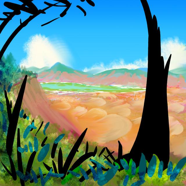
You find yourself soaring over golden-green prairies--clearly wetter than our Altiplano. Trees (green ones!) line the rivers and even dot the plains. The sky is mostly cloudless, but remember: Capsica's denser air can hold more moisture at high altitudes. Thunderstorms worthy of the Great Plains sweep across Chekua.
Chekua's plateau breaks up in the west. The Hazma River gnaws deep into the highlands, creating a dissected world--Grand Canyon mesas and sky-islands. Winds are tricky here but you'll have no trouble finding updrafts, or camping spots, or water--just look for the falls. Tiny threads, most of the year, lost in a stone maze. If you were earthbound, you'd be lost too, in nightmare country--spectacular, but deadly. But wings let you soar miles up to scout for water and glide straight to it.
Past the Hazma Basin is a floating fragment of Chekua, the Lim Plateau, some 500 km long and 200 wide (300 by 125 mi).
West of this, the curving Dzil Range--exactly equivalent to a Terran island arc--creates a cut-off basin of olive woods--a Lost World of rhodophores stranded in green country. The chain of lakes feed into brackish Lake Chogmi in its heart. It's a bigger, saltier, barrener version of the Haadi Basin. Internal drainage doesn't just mean salinization; the highlands all round are cool enough to trap many animal species in the Chogmi Basin. They're speciating at a tremendous rate. Whether some will adapt to the highlands eventually and radiate into this wide, underused habitat, only time will tell. Perhaps they already have, and Chogmi's the origin of many of the Chekuan species you've seen already.
From the north end of the Dzil Range you have several choices:
Yes, we started in spring and now it's early winter. No, it hasn't been nine months. Capsica is small! Remember we crossed the equator? Seasons have reversed.
You cross a ruby strip miles wide, with a sinuous green-brown snake coiling down the middle: the muddy Tsaz River, the largest one sustaining the inland sea of Lake Dirami, and the reason it's no ephemeral Lake Eyre or Chad. On, on! More savanna. Thundering herds of... something heat-tolerant. Even for Capsica, that savanna's hot. A hard life down there in the pit.
You sleep hot, on a steep narrow ridge barely rising into the green zone--Garmoi Ridge, a curving stone wall 3200 m high (10,500'). No running water; just boulders and twisted little trees six thousand years old. Springs do emerge lower down the ridge, but it's a furnace down there, even now in early winter.
East again for hours over equally hot and dry Thamo Valley. The narrow crescent of Lake Thamo far below you--a scimitar of silver curving out of sight to the north. The water mocks you. You're tempted to stoop like a falcon and take a cooling swim and get a drink, despite the ovenlike air down there. Don't do it. Thamo's hot as a bath! Creeks from the high mountains to the east feed the lake or it'd evaporate quickly.
You're starting to fear you'll evaporate soon. Used up your bota yesterday and no refills on Garmoi Ridge.
But ahead are cloud-wrapped crags--the shoulders of Mt Roldai, a volcano in the Numiths so tall (8100 km; 26,600') it's almost Terran. Water! Green shade! Rest!
Here we rejoin those who took the side trip to Valiha Island.
South along the restored Numith Range...
Intro - Touring - North - Chekua Highlands - Southeast - South - SW - Deserts
A day south of Mt Roldai is another giant, Mt Defireen, 9.3 km high (30,500'). You camp on its shoulders, not even two-thirds of the way up, in warm but comfortable weather. Two miles above you, on the summit, you're astonished to see your first streaks of snow. You shouldn't be. We've left the tropics and it's deep winter now. Even Roldai may get some later in the season.
A day after Defireen, some travelers will peel off east onto the Orin Peninsula, the size of France. From the ridges and lakes at its base, I suspect this region is splitting off from mainland Kifura the way Somalia, Kenya and Tanzania are splitting off the African Plate. Of course there's already a Madagascar that clearly did peel off--Valiha, just to the north--so this isn't a bold deduction!
Many native Capsicans also peel off here, to cross the narrow strait into the ridge-and-fjord country of the southwestern Arch, Capsica's naked riftzone. I wouldn't recommend this for tourists; yes, there are four small highlands on Orin making travel here possible for Terrans, and the highest of them, Mt Kumo, is near the coast and the strait, but on the far side, it's a long, long way to cooler, livable heights. Not just hot on those ridges; dry and stony with little shade. The winds here are offshore; storms head away here, hitting Orin. The fertility around you has a price in rain, and the southwestern Arch pays it.
Instead, if you're curious about the Inner Hemisphere, I'd recommend proceeding south another 1250 km (750 mi), and crossing near the mouth of the Antarctic Sea. It's a long, hot, but uneventful trip along a narrow coastal ridge. The head of Kanein Sound gleams silver to the east on Day 1; the cloud-forest quickly thins on the west as the Numiths shrink to hills.
On the morning of Day 2, a long low gap, hot and miserable; you wouldn't have survived this crossing when we began, but you've toughened up by now. I confess I planned the last few days to confront you with this gap at dawn; it's a killer for Terrans, in the heat of the afternoon. Not much relief on the far side--the ridgetop is high enough to be more green than red, but it's hot even when a cloudfinger creeps high enough up the slope to shade you.
Day Three's a long sail southeast, riding the front's updrafts. Still hot, but far less exertion than yesterday. Peaceful.
On Day Four, the mountains fray and fail again. Broken country, low hot and difficult. You must veer inland following a straggle of olive peaks. And it's no better on Day Five.
Intro - Touring - North - Chekua Highlands - SE - South - SW - Deserts
Here the flyway forks. We can head southwest along Kifura's fertile south coast, and back north to the fringe of the desert, completing our circuit of Kifura (as much as is possible; truly closing that loop by flying up the west coast or through the central desert is too dangerous for me).
The other choice, which I'll cover first, is to head southeast along Cape Ozimba. The hills here are still low, but somewhat cooler--more maritime, and we're at 45° south now. And it may not look it, but it's winter! We started in spring north of the equator; by now it's late summer there and late winter here in the south. That was intentional--I wanted to skirt those central deserts in early winter and make it late winter when the mountains start to fail.
On Earth at this latitude and altitude--2-3 kilometers up in the temperate zone in winter--it's well below freezing and mostly depopulated. Only idiots (and skiers; no comment!) deliberately stray into such heights in winter. That's true here too; you haven't met many natives lately. Not this high! They're all down in the foothills, enduring weaker updrafts and slower travel, to avoid the cold winds you find a relief. Up here, days range from 30-40°C (86-104°F) and some nights drop below 25°C (77°F). For locals, needing to maintain body heat close to 70°C (158°F), that slips beyond misery into hazardous!
Next day there's a basin to your right cupping Lake Wingfeather--a pale blue crescent 40 km long and a third as wide (25 by 8 mi), set in dark maroon woods. Well, sober plum rhodophylls at the limit of their range spangled with deep green--the equivalents of our aspen and spruce. The lake looks like a mere pale dot on the map, but it's not snow, not yet. Still warm if not hot.
And Lake Wingfeather means... it's local-tweaking time! Swoop down to the shore, strip off your wings, head into the Wingfeather Inn and place bets with the natives huddling over the hearthfire that you can survive an hour in that deadly-cold water. Then dive on in while they shiver. Lovely swimming, and profitable, too. Try to win a few jewels. Sapphires and rubies are found here on the Ozimba Peninsula, and the local gemwork is exquisite. And portable; one of the few souvenirs worth carrying on the wing that Earth temperatures won't spoil.
One more day southeast through lower hills, and you reach a long, towering ridge pointing ahead. Follow its windward side all the next day. Near its south end is a final great peak, Mt Khiyar, over 6 km high (20,000'). Now, in deep winter, it's actually snowtipped. The last gasp of this fork of the Numiths; to the southeast, the ridge is just half as high, and dwindles steadily. No matter! You've come a long way from the tropics; by now, even hills a mile high or less (1-1.5 km) are enough to keep temperatures bearable. It's late winter now, at 50° south; you could almost endure sea level. Here you really can reach the southwestern Arch in (relative) safety; just head northeast down that dwindling ridge to the sea. The strait's just 90 km wide (55 mi), and broken by islets--low and hot, but the winter sea at this latitude is below your body temperature (if only just) and can cool you if you have to rest halfway. At sea level. Unthinkable though it is.
Even if you continue south instead, you'll be down in that scary zone, you have to: we're nearing the strait to the Antarctic, and there Cape Ozimba is only low hills for the last few hundred kilometers. For two days, slightly incredulous, you glide down into the forbidden ruby jungle you've avoided for months. Well, not ruby here; a dark plum typical of these subpolar woods. But you're alive and in the red zone--in the only season and latitude you can traverse it.
Now the land narrows--silver on both sides, and cloudy purple hills just a kilometer high. Ahead is the strait to the Antarctic--where travel in the red zone is routine, and we'll do most of it in summer--for we need the light. Even at the poles, winter temperatures are better for Terran tourists, but there's no sun at all for months...
Intro - Touring - North - Chekua Highlands - SE - South - Southwest - Deserts
Let's not take that southeast route out of Kifura, but continue toward the fertile south coast. Earth's nearest cartographic parallel looks like South Africa: but Kifura extends to a much higher latitude, though not as far as Siberia. Summers here can be dry; most rain (and even, at high altitudes, a little snow) is in winter.
All, we cross the headwaters of the many-armed Sheff River--low hills and winding valleys, maroon forests. Off to the left, the hills sink away; the lower Sheff and its delta are a great, flat, dense wood, about the densest forest on Kifura outside the tropics.
A higher ridge--still only 2 km (6600')--is the divide between the Sheff drainage and the much drier Goldu Basin, cut off from many of the subpolar rains by coastal hills; it's almost Mediterranean. Groves and meadows, lavender now, though they'll fade in late summer to pale pink. Tree-lined streams, and maroon to olive woods on the higher ridges where we camp two nights. Hot, but not as humid and stifling as the damper Sheff Basin.
Then... the Jalda Plateau. The most Earthlike place in Kifura! A strange lozenge of highland, like a microchip with four contact pins at the corners--long ridges. These look almost like the ridges on Venusian 'ticks', volcanic plateaus with radial ridges. But Jalda's more angular; the parallelogram shape suggests fault block(s).
In any case, it's a genuine California/Spain two miles above the much hotter Capsican lowland equivalent. Daytime temperatures, now in late winter/early spring, are 25deg;C (77°F), dropping at night to 15°C (59°F). The highest peaks bordering the plateau are actually snowy; they're up to 7 km high (23,000').
These paragraphs will eventually expand a lot; Jalda's nearly the size of England, and quite scenic--escarpments, waterfalls, and those uncanny green woods. Though it's lonely country. Sparsely populated, except in high summer, when the chill abates and for a blessed couple of months turns sunny and mild--50-60°C (122-140°F), and tourists flock in. Fickle, seasonal creatures!
Oh, well, it's to your advantage. The few locals tough enough to winter over will welcome your business--and travel tales.
Leaving Jalda, we fly further west for two days over a chaos of low wooded olive-colored ridges, dusty-rose slopes and grassy lavender basins; the heights in spring are nippy, just 35-40°C (95-104°F), with nights down to as 30°C (86°F). It's drier than the coast behind it, or ahead, because we're farther from the sea to the south, and these low ridges let in dry winds off the desert. I chose not to stick to the coast here--if we did, we'd have to detour well south to explore the endless capes and bays of the Mbrela Peninsula, where the sea-winds bring constant rain and forests grow dense indeed. A misty, cool, clammy place to Capsicans; but Mbrela's hills are low, so it's still 35-40°C (95-104°F)--no hotter really, but extremely humid; you'd really feel it.
Still, it's almost Terran, and at sea level! The fringe of the polar zone.
You'll know we've reached the base of the Nekarda Peninsula when you spot your first volcano. The Peninsula would have been an island arc on Earth--a long curving volcanic range paralleling a trench offshore. We'll head northwest along the chain. These aren't the massive Numiths, but more like Earth's Cascade Range--volcanic peaks 3-4.5 km high (10-15,000') with wide gaps between, with ridges only a couple of km high. This part of the trip's a little like island-hopping; as we head into lower latitudes, and the land warms in spring, only the higher summits are cool enough for you to sleep. So don't push--despite the day-heat, fly only in daylight; the sun generates updrafts to carry you across those long gaps. You'll have to zigzag. An aerial dance! I recommend seaward faces of longer ridges--prevailing winds are off the sea and ridges force them up. And it's a trace cooler.
Three or four days of this mindful hopping. Ruby forest below; it looks like some infrared Oregon. Days without a desert in sight! Bizarre for Kifura. But this is the largest fertile region in the south, as big as the Orin Peninsula and Cape Ozimba combined, and then some.
Why is Nekarda so much rubier than the lands we've just passed through, like the Goldu Basin? The cape faces the widest stretch of temperate-latitude sea in this hemisphere; relentless storms all winter and light but regular rains even in summer. And inland, instead of desert, is Ezhnaro Bay, cutting Nekarda off from the great deserts of central Kifura. Dense forest, huge trees--and not just one freak species, but many, in both the rhodophyllic lowlands AND the chlorophyllic forests on the slopes of the volcanoes, too. It shouldn't surprise you. Death Valley's a mere hundred miles from the biggest trees and some of the deepest snowpacks on Earth. Mountains a few miles high are powerful climatic boundaries.
Only on the last day, out near the tip of Cape Nekarda, with the latitude in the high thirties, does the sun turn steady and the woods open into Mediterranean meadows and groves. Mild temperatures year-round, cooled by summer fogs: no more than 45-55°C (113-131°F). A flourishing port city with a pleasant climate, but stick to the mountaintop above town and use binoculars; the nearest you'll get to a city tour. Sorry.
Here you have two choices:
Intro - Touring - North - Chekua Highlands - SE - South - SW - Deserts
From the western rim of Jalda Plateau, it's possible to volcano hop from sky-island to sky-island of relative cool through the semi-arid but not-at-all-semi-hot lowlands toward Lake Fondu, a big freshwater lake pooling nearly all the runoff from Jalda. It's fresh because it drains east into bigger Lake Fara; that's where salts build up. Southwest of Lake Fondu is a cluster of volcanoes rising far into the green zone--the Fondu Knot. Streams are scarce and woods sparse, but you can find them. It's a true oasis for a Terran.
For locals, too--though their villages ring this little highland well below the green zone, down where the temperature's juuuust right--a comfortable 50-55°C (122-131°F). Away from the streams off the highland, the plains are scrub, grass, scattered trees. All red of course. Rather Moroccan--but bigger, drier and of course much hotter, due to nastier deserts inland.
To the north, there's a linear oasis of relative cool: the Pseri Mountains form a wandering, branching, but fairly continuous path of narrow ridges 3-5 km high, through the sea of ovenlike air below. One could, if reckless enough, perhaps ride the updrafts along those summit ridges all the way north to Central Kifura.
Water? Now, in spring, the mountains are as wet as they'll ever be--not very--but none bear snow so they don't store their water long. You'll have to find the few springs or rock-pools or wells that are high up--lower ones are way more common, but by now they'll be in fatal heat. Still, with local guidance it could just be done.
First come the southwest basins: some rain, small salt lakes, basin-and-range; rather African. By far the biggest basin and salt lake is Lake Fara, shallow but 500 km long and 320 wide (300 by 200 mi). Fara's water is hot to the touch and briny, unlike Lake Fondu. But not strongly alkaline--Fara is full of salt-tolerant life. Salt flats ring Fara, and its lesser, intermittent sisters to the north, but the hills have sparse vegetation. Fara Basin's just not the stark moonscape of...
...The Kor Kal Desert to the northeast, directly south of the Chekua Highlands. Heart of the desert. A huge shallow briny inland sea ringed in salt and alkali flats. Dust storms poison the basin. The Sahara? Don't make me laugh! Summer highs here can top 85-90°C (185-194°F). True, that's still far below boiling; remember that Capsica's air pressure at sea level is over twice Earth's, so water won't boil until 124°C (254°F). Sun-heated desert rock faces may pass the boiling point, but not air temperature and certainly not water.
Not that this is a consolation to tourists. Rock, air, water: take your pick. Any will cook you very nicely.
With luck and excellent planning you may follow the Pseris, avoid these diverse cookeries and, desiccated and rather ill (bad water) but breathing, arrive on the Yask Plateau, the first outlier of the Chekua Complex in central Kifura--and a safe haven.
Yask at first looks indistinguishable from the Pseri Ridges you've been following; high enough to be green, but so narrow few springs or streams break the surface--at least up where you can get at them. But Yask is a little higher, greener, shadier, and much wider; more consistent water. You begin to recover. The north end is higher and wider yet, with streams not only drinkable but with swimmable pools (that don't scald you! that aren't scummy!)
After your last few precarious weeks, Yask seems paradise.
I did warn you to skip that desert. Can't stand the place. But it has to be there. Math made me do it.

World Dream Bank homepage - Art gallery - New stuff - Introductory sampler, best dreams, best art - On dreamwork - Books
Indexes: Subject - Author - Date - Names - Places - Art media/styles
Titles: A - B - C - D - E - F - G - H - IJ - KL - M - NO - PQ - R - Sa-Sk - Sl-Sz - T - UV - WXYZ
Email: wdreamb@yahoo.com - Catalog of art, books, CDs - Behind the Curtain: FAQs, bio, site map - Kindred sites