Capsica's homepage, map, giant ref map, geography, gazetteer . More worlds? Planetocopia!
 Capsica: Kurai Peninsula
by Chris Wayan, 2011
Capsica: Kurai Peninsula
by Chris Wayan, 2011
Introduction - North - East & Dorlin Strait - West - High Kurais - Caldera
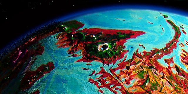
If the Kurai Peninsula were dropped into the Pacific, it'd look much like Hawaii--a chain of shield volcanoes over a migrant hotspot, creating an island chain. The Kurai volcanoes are taller, due no doubt to Capsica's lower gravity, so these Kurai Islands would be larger than Hawaii, and the highest peaks would dwarf Mauna Kea and Mauna Loa; but still, the chain wouldn't seem alien. Just big.
But on their native Capsica, the Kurais look Martian in scale, for the sea here is so shallow their full height is exposed. Mt Kurai itself reaches 14 km high, or 46,000'! Just rib-high next to the four big Martian volcanoes, of course, but still impressive.
Intro - North & Northeast Coast - North - East & Dorlin Strait - West - High Kurais - Caldera

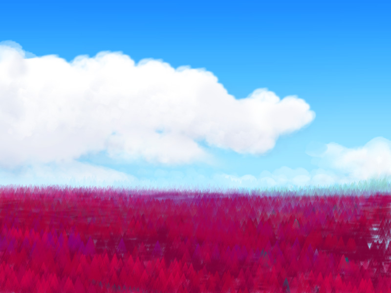
So you're in your wings, flapping leisurely--we're in no hurry here. You're heading southeast; the sea's off your left wing; on the right, the alpine meadows of the Kurai Range float pale in the haze. Below and before you, to the horizon, is a plain covered in tall conifer forest. It could almost be Alaska, but for two things: you're almost naked yet still too hot, and that forest is a deep maroon. Young growth shines out, ruby or magenta; some sprucelike trees are almost purple. It's as if you've fallen into an infrared satellite photo.
These are rhodophylls, at the cool end of their range. Get used to them! Plants using a closer analogue of chlorophyll do flourish on Kurai, but only in the cooler heights, where summer temperatures never exceed 50°C (122°F), or where winters get below 30°C--too cold for rhodofers. That isn't just haze leaching the red from those woods far to your right; as they climb the long gentle slopes of Tsenrek Caldera, the nearest (and one of the lowest) of Kurai's shield volcanoes, more and more somber green chlorofers enter the mix.
That summit ridge, over six km above you (20,000'), is a very different green--the pale green of high, thin alpine meadows. The brief snows of winter have long since melted of course. Tsenrek's not really a mountain, after all--just a ruin. Its summit, six km higher, collapsed long ago; a broad caldera, partly filled by a lake, is all that's left now.
You flap on around Tsenrek's feet. And on. All day! If you need a break, land on the beach. The only other breaks in the ruby canopy are a few boggy, narrow meadows: hazardous landing strips!
Who lives here? I don't know yet. They'll be winged, I'm sure of that, and social, probably somewhat ravenlike.
Toward sunset--early, with those high mountains to the west--a silver-pink gulf opens up ahead. The Gulf of Stuu, dividing the Kurai Peninsula from mainland Chai behind you. The mountains ignore this arbitrary division, stretching behind you over the horizon. Spiral down to the beach and land. Take a swim--the water's warm. I meant that to be reassuring, but probably not the way you assumed. It's never cold here; I meant that unlike some of the equatorial seas, the Gulf of Stuu won't scald you.
At dawn you set out over the gulf, due south. It's cool over the water, only 25 or so (77°F). Enjoy it while it lasts. An hour later the red shore crawls into view and the temperature crawls up toward 35 again... Take yesterday and repeat--easy but endless flying east-southeast.
Repeat for two to three days. Sometimes hills rise inland, sometimes there's a flat red rug to the horizon, sometimes dim mountains rise--the ramparts of Mt Polim, most likely. But always ahead of you is the endless forest plain...
Intro - North - East Coast & Dorlin Strait - West - High Kurais - Caldera

On day four, the ruby plain ends suddenly; the coast bends sharply south. You've reached Cape Polim, the eastern tip of Chai. Congratulations--you've flown your first thousand miles. Graduated from kindergarten!
Inland, to the north, hills slowly mount, first plum, then olive, then green. Sunset comes early: a great mass of cloud's in the west, over the hills. Mountains, I guess we have to call them--though snowless, they're at least Alpine in height.
In the clear morning, that cloud's still there. A cloud of stone! Pale alpine fells and snowfields float hundreds of km away and least ten above you--one shoulder of Mt Kurai.
It grows no closer, for the shore soon bends south. Kurai hovers to the west, unmoving. You've only sailed a few hundred kilometers; what's that to a mountain the size of whole nations?
Near dusk, long low islands appear, southeast; harbingers of Dorlin Strait. The next day the coast swings west, and that long island on the horizon isn't an island at all, but a narrow cape splintered off the Arch, the world-girdling supercontinent comprising perhaps two-thirds of Capsica's land. Dorlin Strait is vital for shipping; only three straits enter the Arctic Ocean, the only truly Terran-sized ocean on the planet, and Dorlin's the shortest route to the far south and the Inner Hemisphere. You even spot a few tubby sailing ships--not many for such a trade artery, but remember that here on Capsica only bulk non-perishables travel by sea.
Wings alter all.
Intro - North - East & Dorlin Strait - West Coast - High Kurais - Caldera
Next day, the coast turns northwest and the far shore drops away. We're angling toward Mt Kurai again, though it's still 200 km away. The coastal hills grow taller, often hiding the ice wall to the north. After a few hours it's time to climb inland for the first time--we're cutting across the base of a long sharp peninsula, Cape Pirvu. In an hour, you surmount the low pass. A few dark green trees spangle the red forest, but I'm sorry, you can't yet claim you've entered the green zone. Patience! Soon.
Ahead, a great gulf of turquoise water: Wolfa Bay (more like "wall far" than "wolf"). The shores are lavender flats, with winding ruby arteries--tree-lined, meandering rivers through savanna. It's the driest land you've seen yet. No mystery why. The winds on this side of the Kurai Peninsula often blow from inland--we're in the rainshadow of massive Mt Kurai, looming due east now.
Head north toward that narrows, just 10 km wide (6 mi); let's cross to the west shore of the bay. Two reasons. One's visible. The color of those plains ahead looks almost Terran: a dull golden brown. Don't be comforted by the familiarity: that's ominous. Red hotzone grasses here dry lavender or dove-gray, not gold or brown. That hue means bare ground's ahead! The rainshadow on this shore is severe; that's a baby desert. I want to be sure you have water. The second reason's invisible: better winds on the west. For the icy heights of Mt Kurai generate relentless downdrafts now in winter: katabatic winds. This cool dry gale slams into the east face of Wolfa's coastal hills, creating a reverse of the usual seaside updrafts; you can ride this foehn or sirocco north for hours like a hawk, and never twitch a nylon feather.
But you ride alone. No locals are out enjoying the free ride. They're used to heat, on this sunny savanna; for them, this 30°C wind (86°F) is a deadly bone-chilling gale.
At last the silvery sheet on your right falls back; just grassy plains, pale pink in this dry winter, but veined in red around serpentine sloughs. Ride the wind on north another hour or two. Climb to that low pass ahead...
And down to a very different bay, Chuma Bay, a broad bight with more lavender and pink dry-grass flats below ruddier, patchily wooded hills. The last few hours of flight north have made a difference. At this latitude, comparable to San Francisco or Athens, winter winds may be gentle and irregular but they blow off the sea; rains are light but there's no gold or brown on the hills. Out of the rainshadow!
Not that there aren't high mountains east, still--by next day, near the head of Chuma Bay, the snows of Mt Yau Gur shine 250 km to the east. Don't be surprised you can see them at this distance, despite Capsica's sharper curvature and closer horizon; Mt Yau Gur is 12 km high (40,000').
I think you've trained enough. The west coast from here on is a washboard of bays and capes--old lava flows. It's no easer than the meadows, groves and canyons inland. From the head of Chuma Bay, let's head due north and start climbing the hills...
Intro - North - East & Dorlin Strait - West - The High Kurais - Caldera
You climb north through higher and higher hills as the air pressure slowly drops. At first flying gets easier--more updrafts, less air resistance--but eventually, as we climb the broad, endless slopes of Mt Blen, we'll pass 6 km (20,000') up, and with air pressure down to a mere 1.2 atmospheres--half sea level's--you start to feel like you're trying to grab vacuum. It's not oxygen shortage--even at Blen's summit the air's just Tibetan, not stratospheric. And you're in good shape by now. But you can't fly up there, even natives falter, and they don't have your clunky ape bones.
Capsica's low gravity is more obvious to the casual tourist, but it's not the only reason you can fly here! The dense sea-level air boosted you tremendously, letting you glide with a much smaller wing area than would ever be possible on Earth. But as you climbed out of that atmospheric soup, you're losing that subtle support. Now you see why I wanted a few thousand miles' training out of you before you ventured onto the shoulders of giants. You'll need that strength. The cube-square law makes it inherently harder for big creatures to fly; on Earth you'd be hopeless, while here you're borderline.
So I think we won't try to reach Blen's icy summit. You'd have to stash your wings and hike. It's brooding three miles above you still, to the east. Mt Blen tops out at 11 km (36,000')! Essentially, your long climb up the slope so far has brought you to what, on Earth, would be a Hawaiian beach, looking up at Mauna Loa above you. Well, not quite Hawaiian; we're at 45° north, in winter; the air actually feels cool, a mere 20°C (68°F).
From the high west ridge of Mt Blen, looking north you can see the cloud-dappled silver of the Gulf of Stuu miles below. Just days ago you crossed that bay, remember?
On the northwest horizon--at this height, hundreds of km off--is another hulking, snowcapped giant: Mt Suzu, the last major peak of the Kurais, 10 km tall--a perfect twin of Hawaii minus the sea.
Beyond it lies the continent of Chai. But that's another tour!
Let's turn away from the north--the Kurais climax to the southeast, after all. On the south face of Blen, the slopes face the sun, heating and generating updrafts. We can ride those toward the next peak in the Kurais, Mt Biru, 160 km to the southeast. It's a virtual twin to Blen. To the south are several merely Himalayan peaks--snowy now in spring, but melting fast; they're no more than 9 km high (29,500').
Considering just how high these "lesser" heights are, Terrans might think of Tibet; but there are differences. Tibet oscillates from dry brown near-desert to frozen white each year; the air's thin and rains are cut off by high mountains all around. Kurai's air is much denser and holds more water. Cold drizzle in winter, with a few snow flurries at most; hot thundershowers in summer. So Kurai's highlands are green in winter, red in summer; two annual blooms.
But animal life can't so easily adapt to the winter cold. Grazers do migrate up to those lush red summer pastures, but the equally rich green winter bloom is grazed only by a few species of flightless high-altitude furballs. For most creatures the food (and the predator shortage) can't compensate for air temperatures about 60°C (108°F) below body temperature. Every minute, calories lost! Capsican higher life, by adapting itself for the lowland heat, has boxed itself in.
Yet Terran horses or buffalo would find the high shoulders of Kurai heaven--if it gets too snowy in winter or too hot in summer, or those red plants taste funny, they could just amble up or down and find greener pastures. Literally greener. Or they might find they like their fodder red.
A few hours south of you, as the condor or tourist flies (assuming no fatal slips), rises a peak so high it still has snow: Mt Yau Gur, 12 km high (40,000'). It has a breached, C-shaped caldera 75 km wide (45 mi) and inner cliffs up to 5 km high (16,500'). The caldera rim has glaciers; the floor is a pocket desert like Haleakala.
We'll fly along the west side. When the caldera collapsed, this wall mostly fell; a curving ridge rises only 1-2 km above you. On the southwest slope, there's a gap where a river escapes the caldera. It'll be hard flying, and the highest elevation I'll lead you to, but hug the slopes low, dodge the boulders, and you may stay aloft--the ground effect helps.
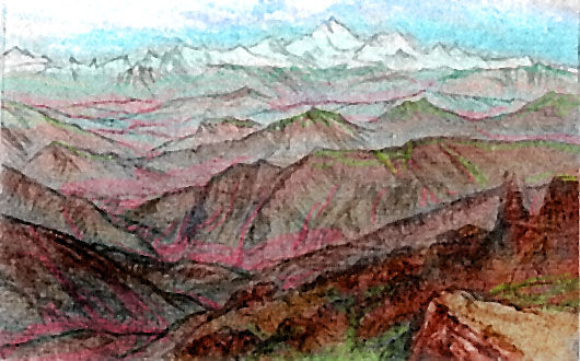
The Yau Gur Gate widens and falls back; we're in the caldera. Before you sweeps a dry plain 7 km up, higher than Denali or Aconcagua. Little secondary cones only as high as Everest dot the floor, waist-high or less against that monstrous icecapped arc of cliff ahead of you. Glaciermelt feeds strips of alpine meadows, but sheltered by those cliffs, the floor doesn't get much precipitation, frozen or not: a few thin winter snows and summer thundershowers. It's a strange place--much more like our Tibet or Altiplano than outside the crater, where you saw lush alpine meadows, dark green woods lower down, and maroon forests down in the foothills.
Intro - North - East & Dorlin Strait - West - High Kurais - Kurai Caldera
Next day, and the day after, we zigzag southeast: ride the updrafts on the windward side of a Kilimanjaro, glide across a maroon valley to the next olive or green cone, and climb again... barely a flap of your wing, yet hard work.
You start climbing steadily. The subsidiary cones grow higher--pure forest green, then pale chartreuse alps, and at last a few summits of bare rock and snow. We're on the shoulder of Mt Kurai itself. Now's the time to use your hardlearned wind-cunning. Veer left and head round the great mountain; the east face is the windward side, and here you can rise higher, into very thin air indeed. I doubt you can reach the snowline, but you can push above six kilometers toward seven (23,000'). Even so, it's a long day's journey, a couple of hundred km, around to the south side. Let's camp here and make a final push tomorrow.
In the morning, it's so cold you actually need clothes! No frost, but it's briefly no more than 10° (50°F). Take your time breakfasting. We want the sun to heat these south-facing cliffs and lava dikes to generate updrafts. Why didn't I have you assault the east face? Well, look upslope. Elsewhere Kurai's "summit" has been a relentless curving wall of ice and rock horns. This south wall is a couple of kilometers lower--a mere 12,000 m high (40,000'). And here alone is a notch in the rim, the scar of some ancient overflow--a canyon over a kilometer deep. It's ice-free, too--these cliffs face the sun. The nearest thing to a breach in the ring!
All right. Take wing. Let's see if you've earned Kurai.
Two hours later, you're exhausted and wingless and still not in the notch. Flown as high as you can. Don't feel bad you couldn't even reach 9 km up--the air's so thin I secretly didn't expect you to hit 8, let alone top it! Anyway, pack up your wings and carry them; we have a little hike ahead. The pass in the Notch is still a couple of kilometers above us. A grueling 1-2 day climb even in Capsica's lower gravity--it'd be hell indeed on Earth. But worth it, I think.
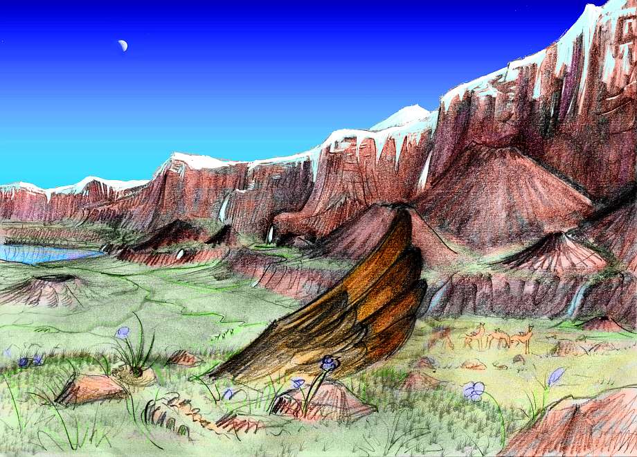
The next afternoon, plodding, exhausted, dizzy, you make the rim. Cliffs four miles tall drop into a hundred-mile gulf. It's not all the same depth; curving terraces mark old lava tides. The lowest seems to be off to the left, nearer the far wall--a deep round lake, the bluest you've seen here. No wonder--it's not just very deep and pure, it reflects an azure stratospheric sky. In the lowlands, the Capsican sky is paler than Earth's. Not here. This isn't Capsica anymore.
For Kurai Caldera doesn't just look like Doyle's cliffwalled "Lost World", it is--a Petri dish of alien climate so inaccessable to lowland Capsica that nearly all its species are endemic. Sorry, no stop-action dinos roaming around! But Capsica's dominant fauna are hot-blooded critters who can't fly over the ringwall--too high, too cold. The only large beasties ever to stray this high were plodding cold-adapted grazers with useless little vestigial wings. You know, groundhogs like you.
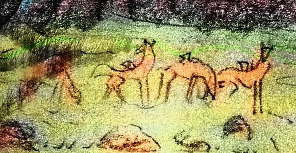
That dark shadow to your left is a herd of their descendants, grazing miles below you. Nziba, they're called. Except for the ubirak of the Antarctic highlands, they're about the only Capsican megafauna that face regular freezes and survive.
Let's unpack your wings and don them. I know the air's too thin. But it's time for some suicidal fun. Jump off the scarp! You pick up so much speed it doesn't matter how thin the air is up here! At two hundred KPH, the wind thundering in your ears, you'll have enough lift to pull out and swoop nearly horizontal. Minutes later but miles away, you crash-land on the meadows of the caldera floor. Off!
Hope you don't have an earache. Yawn and equalize the pressure. You just dropped through a third of Capsica's atmosphere, after all.
So you're in a Himalayan meadow, with a ring of icecapped monarchs above you. The yaks eyeballing you in dull wonder are shaggy enough, though the little chicken wings look wrong. But really, it could almost be Earth.
Let's hike along this creek down to the lake and swim. You can leave your wings here; no one's going to come by and mess with them. Besides, they're good for nothing up here.
So I don't care what your rock skills are--Kurai will kill you eventually, through sheer fatigue if you don't slip. And even if, against all odds, you did climb out, it'd take forever. And we can't have that--this is the Web. No, the thing to do is die comfortably on this pleasant, scenic beach, and click another tour.
Not only will your minerals enrich the sparse grasslands of the caldera floor, your alien enzymes (designed for a body temperature of less than 40°C) might just enrich the local repertoire. The bacteria feasting on you may learn a metabolic thing or two, and pass it on to larger organisms. In a few million years some merely warmblooded creatures, properly adapted to cool weather, could emerge from Kurai Caldera to settle Capsica's vast empty green highlands.
Now that's donating your body to science!

World Dream Bank homepage - Art gallery - New stuff - Introductory sampler, best dreams, best art - On dreamwork - Books
Indexes: Subject - Author - Date - Names - Places - Art media/styles
Titles: A - B - C - D - E - F - G - H - IJ - KL - M - NO - PQ - R - Sa-Sk - Sl-Sz - T - UV - WXYZ
Email: wdreamb@yahoo.com - Catalog of art, books, CDs - Behind the Curtain: FAQs, bio, site map - Kindred sites