Capsica's homepage, map, giant ref map, geography, gazetteer . More worlds? Planetocopia!
 Capsica: east Maisila
by Chris Wayan, 2021
This one's for you readers, who pestered me until I had to build it
Capsica: east Maisila
by Chris Wayan, 2021
This one's for you readers, who pestered me until I had to build it
Introduction - Touring - Strait - East - Central Hills - North
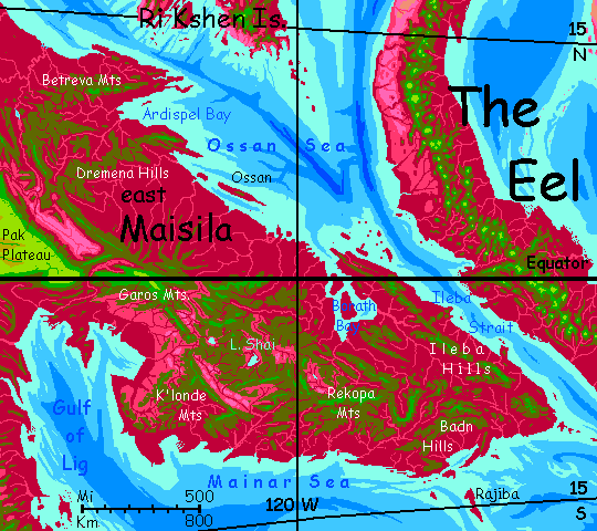
If Capsica's shallow seas were like Earth's, eastern Maisila would be just a dusting of islets--specks on a tropical sea. Paradoxically, Capsica's relative dryness made East Maisila the world's largest rainforest instead. The whole peninsula is lush.
But all of it is uninhabitable, even unvisitable, to Terrans--temperatures are 50-65°C (122-149°F). They'd be even hotter but sunny days are rare; clouds usually cover the whole peninsula, and rain falls every day or two.
So not an oven--a steamer.
Intro - Touring - Strait - East - Central Hills - North
I put this tour off for years--it's so hard to get you through alive. The only way, as is often true in Capsica's lower latitudes, is to stay in the heights--3, preferably 4 kilometers up. Even here, it'll be like touring a hot shower. Don't bother bringing a coat. Or clothes.
Unlike, say, the Andean ranges of The Eel to the east, this part of Maisila has only broken ridges in the interior reaching up, barely, into this tourable zone. Our trip will zigzag. A lot.
The natives find these hills uncomfortable too, now, in orbital winter--not for the heat and rain, of course, for the cold and rain. Yet you'll meet Capsicans on these peaks, bundled up and shivering. A few are fellow tourists there for the views, but most will be practical travelers. Like meeting businessmen atop the mountains of Borneo or New Guinea! Why are they up here? They're riding the updrafts generated by the mountains. Most Capsicans fly; east Maisila is, for them, a natural bridge between The Eel and the cool dry uplands of central and western Maisila, and a very convenient path, too, avoiding the equatorial heat--a bit much even for most Capsicans.
But reaching those cooler heights, and traveling in them, is not easy for tourists who didn't evolve for flight. Even in Capsica's low gravity you're grossly underpowered for the wing area of your strap-on wings. Luckily you can ride thermals most of the time--just as the locals do. No one likes to exert in this muggy heat.
Intro - Touring - Strait - East - Central Hills - North
Terran travelers from the Eel will reach Maisila with sore shoulders, and not just because you're not quite broken in to those damn condorwings (no, you don't break them in; they break you). To reach Maisila, it's a nightmarishly long hot flight in from the central Eel. It starts well enough: the high peaks of the Rabmol Mountains are cool islands in the sky, but as you ride the thermals over Sivlepa Spur west to the coast, peaks drop steadily from 5 kilometers to 4, then to 3. You settle at last, in evening, on a hilltop just 2700 meters high (9000'). Through dim trees, sighs a cool night breeze--just 35°C (95°F). The best you'll get. String up your hammock and get what rest you can; a long dangerous flight tomorrow.
Don't pack up at dawn. Take your time until the low light shines down through the red and green leaves--at this altitude, the forest is mixed. Let the sun climb for an hour; thermals are sleepyheads and take a while to get going on these cold winter mornings. Ride it up, high as you can. Now... head west and a little south. All day.
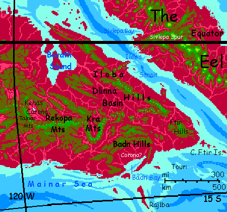
Keep your altitude and chug on despite the pain. You're crossing between continents. Even here at the narrows, Ileba Strait's a good 125 km wide; but even when you see the low red coast of Maisila, you have farther to go--into the cloudy hills, to the next summit high and cool enough to save your life. Camp to camp, you flew 250 km (150 mi) nonstop. Ow.
Welcome to Maisila!
Intro - Touring - Strait - East - Central Hills - North
All next morning, you ride a tailwind southwest from the coast up a chain of hills till around noon a wall appears ahead, capped in green and white--clouds and cold-adapted forests. These are the Ileba Hills--mountains, really, up to 3.5 km high (11,400'). This chain blocks the prevailing winds from the east, generating strong updrafts. It's a popular flyway for locals, and unlike many, it's one you can use too. Muggy, even riding the winds at 4000 meters (13,000'), but at least you're not working hard, as you had to over the the cool water of the Strait. Head southeast till sunset.
Two more days southeast, riding the flyway, taking it easy while your shoulders recover from the strait.
We won't go on through the Ftir Hills to Cape Ftir. It leads nowhere--for humans, I mean.
Instead we turn sharply west, hopping and zigzagging between olive peaks, looking for ones pushing up into the green zone where the nights are bearable.
After a day, you spot higher ridges to the south--the Badn Hills, up to 4200 m (13,800'). They're the north wall of a rather mysterious formation--a corona, a sort of oval blister a few hundred km across. Rare on Earth (Iceland might be one) but common on Earth's geologic twin Venus; Capsica's in between, with a fair number in this region, in the Ri Kshen Islands, and Western Chai. Badn Corona, like many on Venus, has slumped in the center, leaving an oval ring like a stretched impact crater with multiple walls, or a broken caldera. Really broken: on the coast side, the sea has breached the wall, half-filling the center--Badn Bay. It makes a huge harbor better sheltered than most of this coast against the typhoons common all summer.
Plenty of locals peel off from your route, heading for Badn--or points south. Farther offshore, the Rajiba Islands are the best flyway for several thousand km to the subcontinent of Narai.
But that whole south coast is a dead end for Terrans: too hot. Let's keep hopping west. Besides, in a day, you reach the Kra Mountains and can experience a corona close-up; it's higher and cooler than Badn. Kra is a U-shaped highland, like 3/4 of a crater. We spend a full day veering south, west, and north again to avoid the lowland in the middle. It looks distinctive: elsewhere all the lowlands have been maroon to plum-colored, when you can see them at all through the clouds. But the heart of Kra Corona is drier--the surrounding mountains largely block the clouds. You can actually see across--Capsica is small, with sharp curvature and a close horizon; but these mountains rise to 4400 m (14,500'). Lilac savanna with lurid, lipsticky riverine veins of cerise and crimson stretches to the horizon, where a green wall rises, veiled in cloud--the far side.
But at last you're there--the northwest corner. Time to leave this easy, cool highway. Well, cool is relative.
An uneasy morning, sailing northeast over olive-green hills where red and green flora mix and compete: 25-3000 m (8-10,000'). But the land slowly mounts at last back into the green zone. And rises more--peaks reach 4800 m (15,800'). Still quite snowless of course, even in orbital winter--we'd have to go much higher to get below freezing. But warm in the day and mild to cool at night. A pleasure after a week of nonstop heat.
The Rekopa Mountains run due west for nearly 300 mi (500 km). You ride the updrafts along their gentler north slopes--this time of year, the (relatively) cool dry season, the clouds now and then open to show you green mountains and scarlet valleys to the north and west. The lowlands are lighter than before, the trees more open. We're deep inland, and despite Capsica's superb water-transport (warm, dense air), the rains reaching these interior valleys can't match the coast, while evaporation is just as high. In contrast, the south side of the Rekopas get so much rain they're steep, fluted crags and deep canyons, wreathed in cloud-banners and prone to sudden thunderstorms--dramatic but rather treacherous for a clumsy flier like you. Stick to the safer north.
At their west end, the Rekopas sag into a sweltering olive plateau. On the northwest horizon are greener hills. Head for them across the gap. If you don't make it by nightfall, you won't die, you'll just wish you had--good luck sleeping in that stifling mixed forest below. Push on til you reach the Talnas Mountains. This range is probably the (west) wall of a smaller, ill-defined corona. The Talnas run 200 km (125 mi) northwest; a high inner wall, over 4.1 km (13,500') and an outer wall to the west, nearly as high in places, but broken--the upwelling that created the corona weakens here on the rim, and the heavy rains on these more exposed outer slopes erode them much faster. Stick to the high inner wall for now.
Off to your right, down in the corona, the endless forest opens to lavender savanna under quite Earthlike blue skies. Out on the northeastern horizon, in the heart of the corona, Lake Kenas is a blue strip fringed in red trees telling you it's freshwater. While the corona's complete enough to rainshadow its interior, the Kenas River has managed to breach the eastern walls and drain northeast through an impressive canyon over 2 km deep (7000'), then north to the head of Borath Bay.
Speaking of which... this great zigzag south, west and north again wasn't just to rack up miles on the taxi meter; I'm not getting paid to guide you. The purpose is to skirt that monstrous gulf and lowland in the north. Borath's skein of islands and channels are muggy even for Capsicans. Days of flight with no peaks high and cool enough for Terrans, even in winter. Lush-looking, but quite as impassable as the searing deserts of Az.
Did I mention the flies?
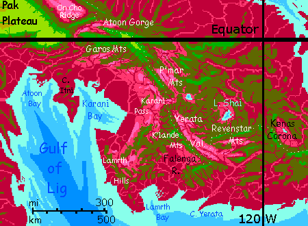
As the main Talnas Ridge starts to slump, let's veer across the cloudforest to the third crenellation of that broken outer wall to the west. Our way lies northwest, and that smaller range is now, briefly, higher and cooler than the main ridge. Rest up in the cool; tomorrow we cross lower lands to the Revenstar Range.
The Revenstars: green forests, swimmable rivers, warm days broken by occasional thunderstorms, long views when the clouds clear. These knobby, scabby peaks seem much lower than 4.6 km (15,100'); we're used to ice shaping peaks that high, but that's never happened here. Uplift versus rain alone. The Alps as sculpted by a toddler.
West along the Revenstars for two days. On the northern horizon is a slice of sky--huge Lake Shai, on a broad plateau just 1600 meters high (a mile), unfotunately all well down in the rhodophore zone, hot in winter and fatal in summer. But to Capsicans it's a refreshing tropical upland, cooler than the muggy lowlands and drier than the chilly, rainy mountains. The lakeshore's a chain of villages and resort towns; the surrounding plateau, farms, woods and meadows. Probably the heart of one more broken corona--the Shai River Gorge is shallow next to the Kenas, but the river breaks through to the sea. The plateau, gorge and lowlands beyond all range from uncomfortable to fatal for you, so stick to the Revenstars. Enjoy the comfort while you can. It ends soon.
Well, now. The Revenstar massif drops away to a deep, strange valley two miles deep. Savanna, dim pink in the haze, with a massive red snake down the middle--the Yerata River, shallow, braided, full of wooded islets. The far side of the Yerata Valley's a faint blue-green mirage barely visible above the heat-shimmer; it's 65-70°C down there (149-158°F). Sorry, you have to cross the Yerata while the sun's up, generating the updrafts you'll need. A hot uncomfortable flight. Stay high or die. Head south by southwest...
Several hours later you reach the far side: K'lande Ridge, a green blade 3-4 km high. Camp and rest as high up as you can find water and shade. Luckily K'lande's high enough to snag way more rain than the Yerata Valley; the green woods break open to meadows only right along the ridgeline. K'lande angles west by south for 200 km (125 mi), overlooking Falenga Basin on the south coast; from that final ridge you could even see a tongue of the sea, for the first time since Ileba Strait when you entered Maisila. But don't follow it--that whole basin's a dead end, unless you're a native.
Northwest instead, the other way along the ridgetop. On your right, the Yerata Valley, a pink and lavender oven, treeless except along creeks dropping from the heights. On your left, the Falenga Basin--white clouds half-hiding a patchwork of red groves and grasslands.
Two days and 550 km later (330 mi), K'lande Ridge sags and spreads into a rolling plateau just 2-3 km high; many red trees among the green, warning your camp will be hot tonight.
A gulf yawns before you--dry pink grasses with veins of dusty rose along watercourses, far below. Karani Pass, just 900 meters high (3000'). It's the lowest, easiest way across East Maisila's central ridges--nothing like it for 2000 km or more, east or west. So you're surpised to see just a modest path--no road. But Capsica's not Earth. Here, bulk materials travel slowly by sea, while news and rush items travel by air. Overland trade routes just can't compete. So Karani Pass is just a geological curiosity.
Rest up as well as you can--the temperature at sunset's 40°C (104°F), creeping down through the endless, bad-sleep night to 35 (95°F) just before dawn. Unavoidable. We're well inland, in deep orbital winter, so it's not too muggy, but your camp on the rim of the Pass is the lowest point we'll reach on this tour, just 2300 meters (7500').
Over the pass at dawn. It's only an hour or two to higher, cooler ground--the P'mar Mountains. At first they too are a broad rolling mixed forest, but at 3 km high, a bit cooler than the last gasp of K'lande behind you. And slowly, as you loft north-northwest, the P'mars rise to a ridge hitting 3800 m (12,500'). Dropoffs on both sides are more gradual--green hills dropping to olive slopes to red groves and pink meadows lost in haze and cloud.
After noon, a thunderstorm. Shelter under trees. Eat and rest. The heat eases--30°C (86°F), the lowest in several days... but the humidity's up, as half the rain evaporates again. Raw rainfall numbers on Capsica are misleading to Terrans, since so much is lost soon after landfall; it's why I haven't mentioned them. There are deserts getting a meter of rain a year--an absurdity on Earth. Push on along P'mar Ridge and camp at its end...
Over a jumble of olive hills, on the northern horizon, loom cloudy green crags. The much higher Garos Mountains, up to 5.5 km high (over 18,000')--the first finger of Maisila's great altiplano.
Two pleasant, mild days northwest through the craggy heights of the Garos massif. Impressive when not wreathed in cloud.
Then out on Garos Keel, thrusting steepwalled into dry Atoon Gorge, 3-4 km deep (10-13,000'). The first near-desert you've seen in this generally wet region. The surrounding mountains just cut off rain from all directions.
Camp, admire the view, rest and sleep. In the morning you have to cross Atoon Gorge from the tip of Garos Keel to On Cho Ridge, a gulf of about 75 km (45 mi). By midmorning there are huge updrafts off that sunken oven, so it's not that hard, just hot.
Once you reach On Cho, it's still hot, but there's water and shade under green trees: this narrow ridge rises well into the green zone, to 3900 meters (12,800'). For Terrans, On Cho's a survivable bridge running 250 km (150 mi) over this otherwise fatally hot savanna region; but it's a popular flyway for Capsicans too, even though they don't need to cling to the heights. But they like the updrafts, powered by the hot dry valleys on both sides. One side or the other always has rising air. And frankly, even the locals aren't wild about savanna hitting up to 70°C (158°F). This near the equator, Capsicans start acting like Terrans, clinging to the heights. True, most camp a mile below you where it's more pleasant for them, 50°C (122°F) instead of 35-40°C (95-104°F).
Here your path forks. Either...
Three days up the Povara Range. Not too bad, now that you're used to the muggy heat. The Povaras run a full 640 km (400 mi) northwest. The central stretch rises to 4.9 km (16,100'); quite Terran heights, with green forests and meadows. Lush wilderness! It's just too cool for most Capsicans; those heights are just 25-30°C (77-86°F).
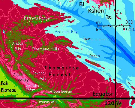
To the southwest of you, the great Arsen Valley is 600 km long and 200 wide (375 by 125 mi). Equatorial, sunny, and low-altitude, it's one of the hottest places on Capsica, regularly reaching 80°C (177°F). Clear skies over lavender prairies. Another (and drier) world. With mountain ridges 4-5 kilometers high on both sides, storms have to fight their way in.
Deep gorges on Earth suffer the same rainshadowing--Andean valleys, and the Owens Valley, and east of Tibet, the parallel gorges of the Salween, Irawaddy, Mekong and Red Rivers. The heights wring out all the rain.
To the right--northeast--it's another world. Thombitse Forest, the largest unbroken rainforest on Capsica. A low plain at least 1600 km long and 500 wide, (1000 by 300 mi). Year-round rains, up to five meters.
After a day, there's a tempting spur--the Dremena Hills to the northeast. Unbroken rainforest, but high enough so some green trees enter the mix. Still unpleasantly steamy, and while the Dremenas are broad and look like they're going somewhere, they splay out into lowland jungle like a dull green hand. A dead end. Don't.
Two long days more, up Andayr Ridge, a narrow windwall much like On Cho Ridge, but lonelier--no other great mountains, just seas of puffy cloud over Thombitse Forest.
The mountains start to curve east, in a long arc that'll take several days. They change character, too--no more long ridges. Now there's a mist-shrouded volcanic cone every hundred kilometers or so, rising over mazes of olive-green hills and deep red canyons, all densely forested. The Betreva Mountains run 880 km (550 mi) east and a bit north.
The first day, peaks reach 3.5-4 km (11,500-13,000'): cloud-wrapped, stratovolcanic cones manteled in green woods and fern-meadows. Off to the northwest, through a herd of cumulus sheep, you occasionally spot the gleam of Lake Arsen, 50 km long and 40 wide (30 by 25 mi); the only lake of any size in 1000 km or more. Not by chance; the heavy rains here erode dams and fill basins with silt. This principle applies to Earth too: Amazonia has few lakes; they just can't last. It's rugged but drier regions like Tibet that abound in them.
Hop between sky-islands--two or three a day. Not hard--just be sure to time your last flight so you don't get caught over low red rainforest at sunset--it's a humid 50°C down there (122°F). Though near sunset these Fuji-like peaks, miles above their foothills, flame like green torches for an hour after the basin's in purple shadow; Fujis are hard to miss.
Next day, the climax of the Betreva range. A cluster of giants reach 4.5-4.6 km (c.15,000') and the 'foothills' are olive to green--near 3 km up themselves! Lazy, easy. You might almost be on Earth.
On the third day, you're nearing the coast. Volcanic summits grow lower and hotter, and their flanking hills sag fatally low. The forest below looks much the same--deep red--but you're out of the equatorial rainforest now, into a monsoon zone, and winter's the dry season. So while it's still hot for Terrans, at least it's less humid, and the fatal heat/humidity line's a hair lower. You get used to sleeping as low as 3 km up (10,000'). But then, you have to.
On your last day, near the coast, you're reduced to peaks just 2.5 and 2.7 km tall (8-9000'). Pick the highest and camp and try to sleep in the muggy 35°C night (95°F).
Endure it. You have to rest up; leaving Maisila isn't easy. To enter from the Eel was a nonstop flight of 250 km (150 mi). This will be worse.
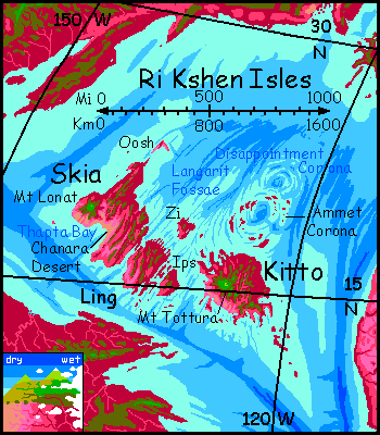
Head north, out to sea. After hours, and 200 km, you'll have false hope, as low red islets swim into sight--the first outliers of the Ri Kshen Archipelago.
Why false? They're real, not mirages. But they are climatic mirages--far too hot for you. Hours more--you need to reach Ling, the third largest island, and get well into the hills before you see a hint of green, and set down at the summit of the highest peak you can find--not very, just 2.3 km (7500'). Even now in late winter it's oppressively hot, at least 35 & more likely 40°C (95-104°F), though at least the humidity's fairly low. Enjoy your well-earned sleep. If you can.
Congratulate yourself. You're miserable, but not dead. And you're in the Ri Kshen Isles.
To repeat: you escaped Maisila alive.
For years of building Capsica I didn't think that was possible; it's why I put off exploring this region so long. I knew a monthlong trek through that soggy sauna--even writing it I'd need to vividly picture the whole muggy slog--would give me wrinkles. Mind over matter.

World Dream Bank homepage - Art gallery - New stuff - Introductory sampler, best dreams, best art - On dreamwork - Books
Indexes: Subject - Author - Date - Names - Places - Art media/styles
Titles: A - B - C - D - E - F - G - H - IJ - KL - M - NO - PQ - R - Sa-Sk - Sl-Sz - T - UV - WXYZ
Email: wdreamb@yahoo.com - Catalog of art, books, CDs - Behind the Curtain: FAQs, bio, site map - Kindred sites