Capsica's homepage, map, giant ref map, geography, gazetteer . More worlds? Planetocopia!
 Capsica: west Maisila
by Chris Wayan, 2022
This one's for all you procrastinators. I started Capsica in 2010--and here I am.
Capsica: west Maisila
by Chris Wayan, 2022
This one's for all you procrastinators. I started Capsica in 2010--and here I am.
INTRODUCTION
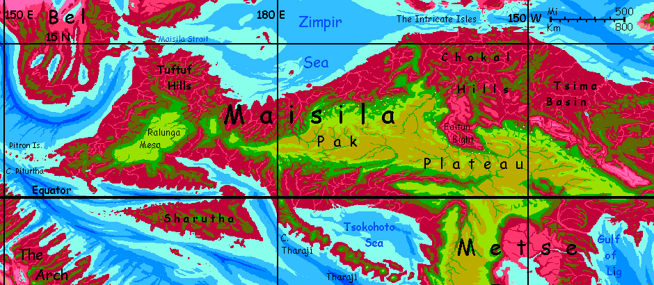
If Capsica's shallow seas were like Earth's, Maisila would be something like New Guinea--a T-shaped land with rugged highlands above a tropical sea. It's just that Maisila's much bigger, more Australia-sized, and its stem is just as long and rugged as the crossbar.
Capsica's relative dryness turned this continental highland of lighter rock into high plateaus, way cooler and drier than they'd be at sea level. Tropical Tibets! And much of the "sea floor" around the continental highlands is just above water--and, being in the tropics on a hot world, gets torrential rains. The lowlands of Central Maisila are lush--the world's second biggest rainforest (after East Maisila--and it's right next door).
But this equatorial Eden has an angel with a flaming sword at the door--for Terrans only. How flaming? Daily temperatures are 50-65°C (122-149°F). They'd be even hotter, but sunny days are rare; clouds usually cover the lowlands, and rain falls every day or two. So, not an oven--a steamer. The thermal angel keeping you out waves a flaming... teakettle.
I put off writing any Maisila tours for years--it seemed so hard to get you through alive. The only way, as is often true in Capsica's lower latitudes, is to stay in the heights--3 or preferably 4 kilometers up--and travel in orbital winter, when it's drier and cooler. If not cool. Even up on the Pak Plateau, it'll be like touring a hot shower. Don't bother bringing a coat. Or clothes at all. All you really need is your strap-on wings. Capsica's low gravity and high air pressure make human flight practical. Besides, there are few alternatives; Capsicans are all winged, and land and sea transport (except for heavy cargo) slow to nonexistent. It's fly or nothing.
This tour will cover only the central and western part of the equatorial crossbar of the T. Unlike the narrow, chaotic ridges of eastern Maisila, the center and west have a huge altiplano, Pak Plateau, reaching well into this tourable zone. So the core plan is simple--follow the rim of the plateau, where it generates great updrafts, letting you ride effortlessly for days. The question is how much we can detour, to let you see at least bits of the lowlands--they're 3/5 of the land area, after all.
The natives find Pak Plateau uncomfortable too, now, in orbital winter--not for the heat and rain, of course, for the cold. Yet you'll meet Capsicans on these peaks, bundled up and shivering. A few are fellow tourists there for the views, but most will be practical travelers. Like meeting businessmen atop the mountains of Borneo or New Guinea! Why are they up here? They too ride the updrafts generated by the heights. Most Capsicans fly, and for them, Maisila's a natural bridge east to The Eel, north to Fulisse and Bel, west to The Arch and SW Bel, and south to places I haven't outlined yet--Maisila's Stem, the subcontinent of Narai, the Europe-sized "temperate" lands south of that, and eventually, the cold but still fertile lands of the Antarctic.
But reaching those cooler heights, and traveling in them, is not easy for tourists who didn't evolve for flight. Even in Capsica's low gravity and dense air, you're grossly underpowered for the load on your strap-on wings. Luckily you can ride thermals most of the time. It's not cheating; all the locals do.
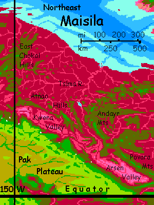
NORTHEAST PAK
We'll enter the region by the easiest route--from East Maisila, along On Cho Ridge to the eastern tip of Pak Plateau.
Along the north rim four days. Cliffs to your right drop into a searing, semi-arid basin, Arsen Gorge. Tan rocks, pale pink dry grass, and golden dunes in one great swath. Shimmering on the horizon are the green peaks of the Povara Mts, a good 200 km off (125 mi). A red snake whips down the valley: the ever-shifting Tsima River. Under your wings, a green-gold grassland, the plateau rim, so much higher and cooler that chlorophyll predominates. Inland to your left, what seem like rolling, wooded green hills. They're really mountains, but without snow you have no sense of scale; they rise another few km above you, up to seven km high (comparable to our Aconcagua.) They don't look it because ice has never sculpted these tropical peaks--Capsica's just too hot.
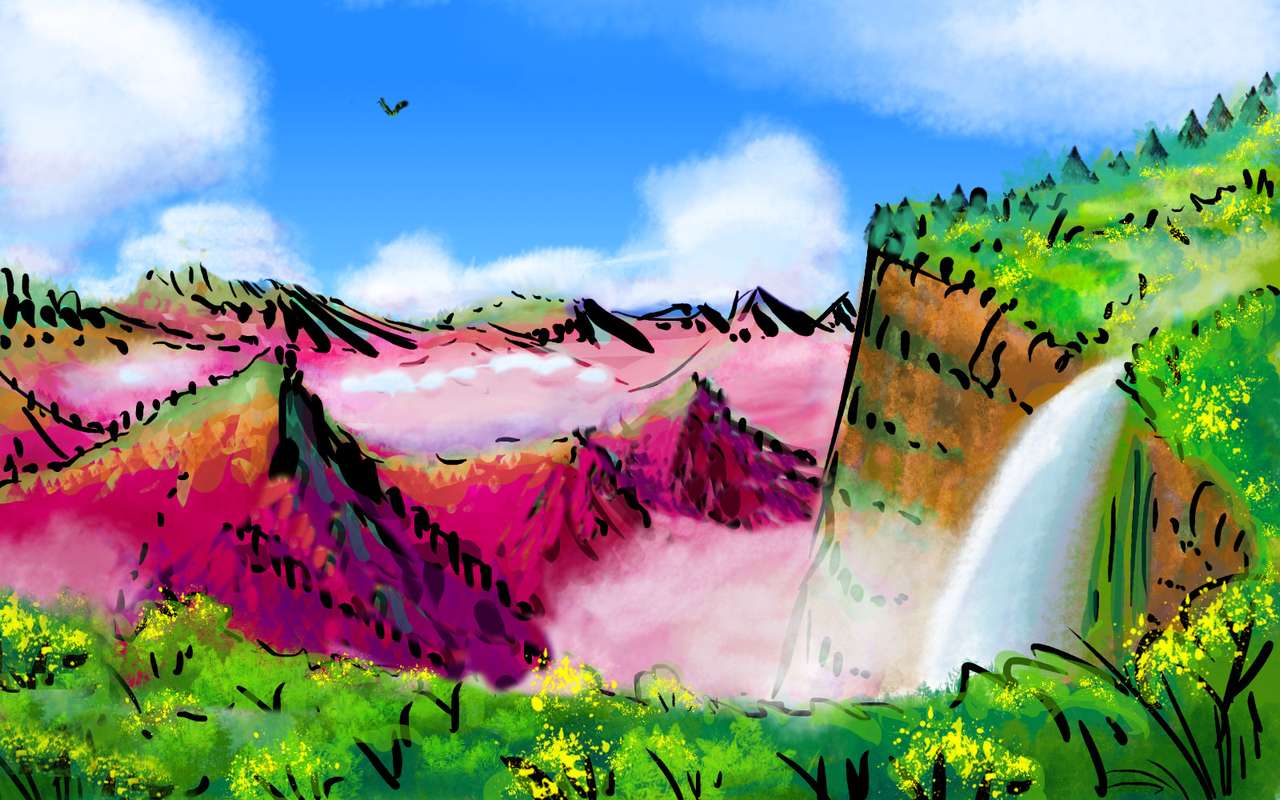
After two days, a slow change in climate: the cliffs turn striped as every ledge gets covered in hanging gardens--green up high, olive and red below. You're creeping out of the Povara Range's rainshadow. Dawn and sunset, pale cloud-banners twist, half-hiding the abyss. Creeks fall in cascades; the spray nourishes red streaks.
Around a buttress, a hanging cloud that doesn't move--but roars. The first of many great falls on this rim.
Two days along this geologically identical but climatologically astonishing dropoff--falls, mist and clouds half-hide Kwera Valley, Arsen's western, wetter branch. Kwera's floor is a network of red riverine strips and lavender meadows dotted with groves of red oaks. Like looking from Yosemite or Roraima's rim down on... Portugal. Though it gets wetter as you go--the Atnao Hills on the horizon just don't block the tropical rains like the wall of the Povara Mts.
On the fourth day, the plateau seems to end abruptly--a dim red cloudy gulf beneath you. Faitun Bight! A great gulf in the plateau. Here, a choice:
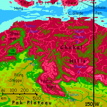
Beyond the Fall, the rim runs roughly north. This tongue of the plateau, Psira Mesa, has no tall rainshadowing ridges, so every ledge is lush. Waterfalls, banners of mist. Even now in orbital winter (the local dry season) a little rain falls nightly. Instead of hourly, as in summer...
At last the mesa rim frays into canyons then ends in a rugged abyss. But ahead on the horizon is a second chance to peel off north toward that (slightly) cooler tour, Fulisse. Just ride the excellent updrafts along the curving Sima Range (3-4 km high, and transverse to the prevailing sea-winds; it forces them up like a wall, making a splendid flyway) to a long, difficult sea-passage (about 250 km or 150 mi between heights cool enough to survive--many hours on the wing, and nowhere to rest) to the isle of Hota, though the final crossing to Fulisse is then quite easy. Let's not go and say we did.
NORTHWEST PAK
West of Psira Mesa, we'll skip the dead end (for humans) of Uk Mesa and head south a couple of hours, then west, northwest, southwest... Pak Plateau's rim here is dramatic, vertical, but broken up. Great scallops have been gnawed out. Falls. Shallow but immense arched caves like Earth's Mesa Verde--and like them, settled. But these aren't ruins. Pak Plateau has a dense population for a Capsican upland. It's just that most residents leave few traces--they live in cliffdwellings here where homes require little building--you're already sheltered from the tropical rain--and updrafts make travel easy. The rich grasses above are excellent grazing land, while the lush red forest below provides fruid, nuts, wood and fish.
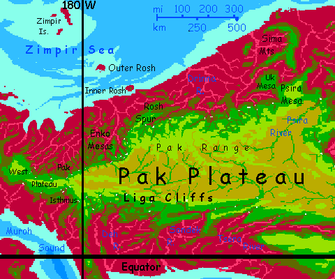
A few days steadily west--the Pak Range on your left, 7 km high, the rim beneath you (not just for the view--for the updrafts), the Drinna Basin yawning to your right...
960 km later (600 mi), the Rosh Spur rises before you--a green ridge 6 km high across your path. Locals follow the Spur north as it frays into the Rosh Hills, then the Rosh Islands, another 320 km out to the Zimpir Archipelago, then on toward southern Bel. You could get as far the summit of Inner Rosh, but Outer and the Zimpirs are just too low and hot for Terrans, even now in orbital winter.
Instead, you have a rough day climbing over Rosh Spur--a 1.5 km climb (5000'). But skimming down the far slope is fun, and you make good time--though the locals zip past you diving at 160 kph (100 mph).
At the foot of the Spur, a surprise--the Rim here drops off to the west, right in front of you. Green mesas rise out of the misty maroon abyss--Pak Plateau here breaks up, dissected into the Enko Mesas. Hundreds of Roraimas. Quite passable for Terrans--you're skilled enough now to cross such gulfs and camp on spires if need be--but there's no need. Skirting the whole dissected basin is simpler.
South a few hours, and Pak Rim turns west again. West, west, west. Much like before Rosh Spur, but two days later, the Pak Mountains south of you subside to rolling hills. By day three, the dry altiplano, grass gone golden now in the dry season, stretches south to the horizon. Since Psira Falls, you've gone 1600 km--a thousand miles--nearly twenty degrees round the planet! No surprise there--Maisila is narrow, but it stretches over 100°.
Even after the isthmus, the West Pak Plateau runs another 400 km (250 mi). Its central ridge occasonally tops 5 km high (16,500'), blocking views south again, but it's nothing after the Pak Range. Next morning, near the end of the Plateau, through the cloud-castles to the north you spot silver--Leng Sound, a tongue of the Zimpir Sea. It wasn't just the southlands narrowing! This tour only seems endless...
A gulf 25 km wide (15 mi) and two km deep--not quite down to the true red zone, but plum and maroon trees outnumber the green, marking dangerously hot and humid depths. You have to cross in one go; no safe havens down there!
Now, after weeks, we're not strictly on Pak Plateau any more. It's breaking up at last. This lesser sky island, just 320 km long, is called Yongolop Mesa. Still 3.5 to 4 km high (11,500'-13,000'), with peaks rising to 4.6 (15,000').
A full day across Yongolop--winding between rugged central peaks, all green-wooded and cloud-wreathed. Could be Amazonia, except for being high as the Altiplano.
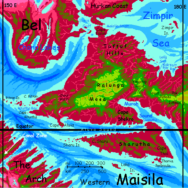
A second olive gap. Maisila's final plateau, Ralunga Mesa. Much bigger than Yongolop--1000 km long and half as wide (600 by 300 mi). Two east-west mountain ranges over 6 km high (c.20,000') bookend an alpine plateau 3-4 km high (10-13,000'). Again, most people here live in cliff overhangs--indeed, whole cliff-cave towns.
West-northwest a day or two around the rim of Ralunga...
FAR WEST
Here we face another choice:
The Tuftufs' highest knobs are just 2700 meters high (9000'). Through dim trees, a cool night breeze sighs--just 35°C (95°F). The best you'll get. String up your hammock and get what rest you can; a long dangerous flight tomorrow.
Don't pack up at dawn. Take your time until the low light shines down through the red and green leaves--at this altitude, the forest is mixed. Let the sun climb for an hour; thermals are sleepyheads and take a while to get going on these cold winter mornings. Ride it up, high as you can. Now... head west and a little south. All day.
Keep your altitude and chug on despite the pain. You're crossing between continents. Maisila Strait's just 25 km wide (15 mi); but even when you see the low coast of southwest Bel, you have farther to go--into the cloudy hills, to the next summit high and cool enough to save your life. Camp to camp, you flew 160 km (100 mi) nonstop.
You've escaped Maisila alive! For years of building Capsica I didn't think that was possible; it's why I put off exploring this region so long. I knew a month-long trek through that soggy sauna--even writing it I'd need to vividly picture the whole muggy slog--would not just kill off readers, it'd give me wrinkles. Mind over matter. Well, wind over mangrove...
But before you turn to go, look south across the empty bay. It's not the VERY end of Maisila. The far side of Piturtha Bay is a cloud-topped ridge: Cape Piturtha, a finger reaching a few miles farther west.
Turn and look west into that gaudy sunset. Unlike the bay, the sea at your feet is spangled with backlit sails--all ships from Maisila Strait headed for the Inner Hemisphere must round Pitron and Piturtha Heads, on their way to Seluria Strait, Torlash Sound and the Canal (what canal? Just the Canal, on Capsica. The only one that matters!
Look past the ships. Those salmon cloud-castles are getting forced high into the tropical air by the hills of the Pitron Islands, a lush and pleasant chain stretching hundreds of kilometers out--the real end of Maisila, and a flyway to the Arch, not too far north of the Canal Zone. But I meant pleasant for locals; not for you. The isles are no more than a kilometer high. Their cloudy summits cool the air from the year-round average of at least 60°C (140°F) down to a mere 50°C--122°F.
Neither a ship nor borrowed wings will get you across that sea.
So you turn your back on Capsica's Polynesian Eden--for you, a poisoned apple--and start back east to the higher halo of hills around Maisila's spine--back where you can survive--two miles up. Preferably three.
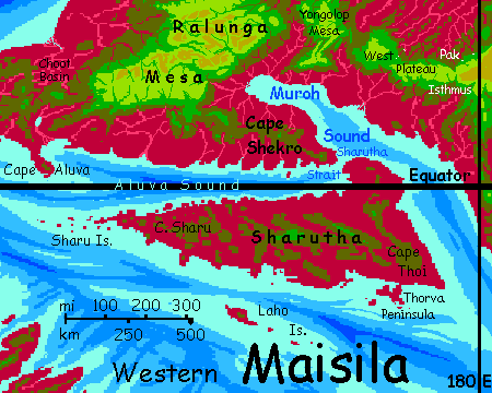
SHARUTHA
East two or three days along the south rim of the Ralunga Plateau. Rugged spur ridges break up this coast into separate valleys. On Earth they'd be have different languages and peoples, but Capsicans fly; the ridges aren't barricades to them, but high-rise apartments with great views and convenient updrafts.
Another fork...
But I wouldn't recommend it. Most Capsican travelers are just passing through, heading for the Sharu Chain off the western tip, lead to the wide washboard country of the Eastern Arch. That flyway's too long, low and hot for Terrans; Sharutha's effectively a dead end.
Over the gap to Yolongop, and east along its rugged, scenic south rim.
Over the second gap to the West Pak Plateau.
Along its south rim a couple of days. Not so different from the north! Elsewhere on Capsica, opposite sides of a plateau are generally quite different, but Pak runs right along the equator. Rising air generates frequent rains on both sides, even now in the cool season.
Half a day after Pak Isthmus, another fork...
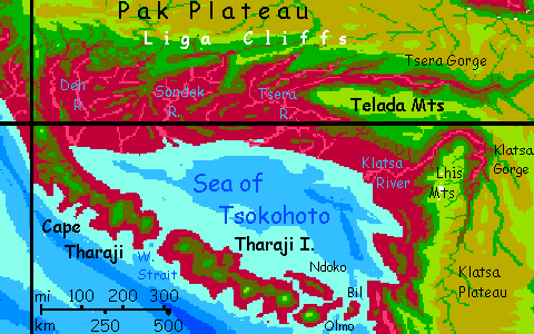
THARAJI OR LIGA?
Tharaji's not quite Java--only half a dozen volcanoes, somewhat larger but farther apart. Still it's hard to escape the parallels.
At the far end of Tharaji over a narrow strait lies Olmo, dominated by a tall cone of the same name, some 4.7 km high (15,400'). Camp high on the flank, in the true green zone--not a rhodophore in sight. Despite the lush woods and frequent rains, you'll have to hunt for surface water; the lava's porous. But there's one trickle-fed pool; hydrate, cool off and rest up. The next couple nights won't be so comfortable.
Next day, soar along eastern Olmo, a low, twisting tongue of lava flows and low cones, though every eruption's quickly covered in maroon trees. Over a 40-km strait (25 mi) to the last and smallest isle, Bil. A lone cone, red-skirted and olive-capped, rises to 2750 m (9000'). It's hot, but does have shade. It's early, but camp here; it's the best site you'll get, 40°C or not (104°F).
Next morning you sweep fast down the slope to the eastern shore, then out across 75 km (45 mi) of water, Bil Strait, back to the mainland. Tiring, and no reward at the end; you need cool heights here too, and while mountains rise steadily inland, it's a long tiring climb to reach a summit comparable to Mt Bil. Nothing higher lies beyond; you camp hot, tired and miserable.
Next day you must cross a low, broad dusty rose basin of brush and scattered trees; the first real opening you've seen in these endless equatorial lowland forests. The area's somewhat rainshadowed by Klatsa Plateau ahead. Only at the end of the day do you climb into real heights, the Bil Spur--a tongue of Klatsa--into temperatures below 35°C (95°F).
You've made it out of Maisila to Metse, a north-south plateau thousands of km long; if you fattened the Andean altiplano to triple its width you'd have something like Metse. But you can't tour Metse yet--don't click! I'm still overwhelmed by Maisila and the Crunch.
So head north, back to Pak Plateau, along the great wall of the Lhis Mountains. When I say great I mean GREAT. By nightfall you're on the flank of Mt Lhis, just over 10 km high (33,000'). Lhis is dusted, incredibly for a peak within ten degrees of the equator, with a veil of ephemeral snow.
North another day, you'll hit the jagged edge of Klatsa Gorge. It wraps around the end of the Lhis Mountains, 3-4 km deep, 50 wide (2-2.5 mi deep, 30 wide). North of this abyss, the Telada Range and Maisila again...
Three days of steady updrafts, clouds and waterfalls: the Liga Cliffs. The Deh Mesas, Sondek Spur and then Sondek Gorge with its great falls, Tsera Spur with its high passes--hard work in thin air (as thin as 1.2 Earth atmospheres!) but nothing you can't handle by now. Next, the side canyons of Tsera Gorge--abysses to cross, or skirt upriver, each big as the Grand Canyon. The main gorge of Tsera is huge--3 km deep, 50 wide, 500 long (2 by 30 by 300 mi!)
It's arrow-straight, so I doubt this is just river-erosion; the region's a T-junction where east-west Pak Plateau and north-south Metse Plateau meet, with great tension; 2000 km to the southwest, the Rift is spreading, pushing the Metse plate in this direction. But it snags on Pak's plate, twisting it, opening cracks as it rotates. Cracks miles deep!
South across Tsera Gorge to the Telada Mountains, 8 km high (26,300'). And they look every inch of that, rising from this deep-cut gorge, bared head to toe. Now, in orbital winter, the highest peaks have even been known to get frost! No visible snow of course, that's rare; we're right on the equator.
East to the Narrows... Another opportunity here:
SOUTHEAST PAK
Two days east across Pak's inland. Big... drier savanna than you saw anywhere the rest, and fewer herds. Nowhere easy for herders to build cliff-dwellings, either, here it's claustrophobic sod houses, heavy stone towers (and this is quake country), baskets on steroids (flimsy in a storm) or nothing. Big as Montana and just as lonely. Cut off from sea air, the climate's continental. Hot now, and really fierce in orbital summer. To fly here, at high altitude but without the strong updrafts of the rim, you really have to work.
A long, hot, exhausting day. You camp by a creek 4700 meters up (15,200'), swim, but barely feel cooled in the mild water. Streams here pour out of the black hills (dense-forested with chlorofers) to the south, just 5.2 km high (17,000'). Nothing like the cold creeks of the Telada Mountains... But once you're out, relief--evaporative cooling really works in the drier air.
After a day, though, a gigantic peak slowly creeps up to the southeast: Mount Pso. Snowless, but 9.5 km high (over 31,000'), this giant's south face plummets in a 45° scarp from summit almost to sea level--from frost to 60°C (140°F). You can't see that from here--the side's barely half that tall, 4.8 km (15,750'). Even if we took an extra day to swing round the rim side, we probably couldn't see much; a peak this big shoulders that humid lowland air up into perpetual banners and thunderheads. Fun for locals, but you'll likely get lost, drenched or electrocuted. Let's stick to the dry side.
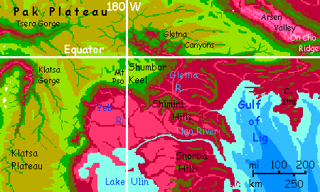
Pso is just the high point on the rim of Shumbor Keel, a diamond-shaped plateau thrusting out from Pak, mostly 4-4.5 km high (13-15,000').
Once past Pso's shoulder, you face one final fork in the flyway:
Then the plateau sags from over 4 to about 3 km (13 down to 10,000'). And then drops away into a red gulf. Camp and rest.
In the morning, you must cross the mouth of Gletna Canyon--not a single gorge like Klatsa or Tsera behind you, but a baffling complex that's eaten deep into Pak Plateau. Here the hard top layer, the Pak formation, is thinner and over eons has cracked and eroded into a maze like Noctis Labyrinthus on Mars. It's why I'm advising you to cross at the mouth; inland it just gets wider and more treacherous.
The far rim's higher--fully 4 km, and no more than 35°C (95°F). Even less under deep trees and at night. Just don't camp at the brink. You never know when another slab will give way.
East of Gletna's mouth, it's an easy run--two days east, riding updrafts along a straight rim. One more canyon-mouth to cross, but it's nothing to you by now--an hour or two over a mile-deep gulf that'll steam you do death if you fall. No big deal.
On the third day, you reach the eastern tip of Pak Plateau. To the northeast, a high, narrow ridge leading into Eastern Maisila--On Cho Ridge.
Where we began. Full circle. After just 10,000 km, give or take.

World Dream Bank homepage - Art gallery - New stuff - Introductory sampler, best dreams, best art - On dreamwork - Books
Indexes: Subject - Author - Date - Names - Places - Art media/styles
Titles: A - B - C - D - E - F - G - H - IJ - KL - M - NO - PQ - R - Sa-Sk - Sl-Sz - T - UV - WXYZ
Email: wdreamb@yahoo.com - Catalog of art, books, CDs - Behind the Curtain: FAQs, bio, site map - Kindred sites