Capsica's homepage, map, giant ref map, geography, gazetteer . More worlds? Planetocopia!
 Capsica: Narai Peninsula
by Chris Wayan, 2023
This one's for you readers, who pestered me until I had to build it
Capsica: Narai Peninsula
by Chris Wayan, 2023
This one's for you readers, who pestered me until I had to build it
Introduction - Intro - Touring - East - North - West - South -
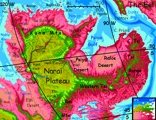
Narai is an Australia-sized lobe of the pseudo-continent of Maisila--"pseudo" because it in turn is just an Africa-sized lobe of Capsica's dominant landmass. Of course if these geological structures were on watery Earth not drier Capsica, Narai would be a true continent, or at least big island, maybe a third the size of Europe. Only because Capsica's seas are so shallow does half of this platelet rise above water at all.
Narai's shores are low, often dry, and very hot (routinely 60°C and occasionally topping 70 (140-158°F!) Inland, however, the Narai Plateau and the Tsi Mountains are extensive and quite high, 4-8 km (13-26,000'), rising above Capsica's torrid zone (marked by red vegetation) into air cool enough for Terrans to feel comfortable, where the predominant vegetation is green.
Ecologically and culturally, Narai feels continental--big and cut off from other landmasses, with only two ways in or out, and one of those quite difficult--a long flight in strap-on wings across the channel from The Eel, that small, snaky but undeniable continent to the northeast.
Narai stretches from 20 to 42° south; its lowlands, wet or dry, summer or winter, are hot even for native Capsicans, and fatal to Terrans: averaging 60°C (140°F) and up to 70°C (158°F). Luckily Narai is dramatically vertical; the central plateau resembles a greener Tibet or Altiplano, averaging 4 km up (13,000'), with peaks in the Kuna Range topping 8 km (26,000'). Spurs from the Narai Plateau radiate in all directions--flyways of higher, cooler air making much of greater Narai visitable. The highest peaks in the Kuna and Tsi Mountains get frequent winter snows; the southern Rai Range is snowcapped much of the year, though no glaciers have formed.
Capsica has low gravity and dense air; in rented strap-on wings, humans can fly. Just not like the locals! You're clumsy, underpowered, and inexperienced. Treat advice accordingly; translate "easy" as "challenging" and "hard" as "fatal". Still, if you ride thermals more than use your feeble muscle power, you can go several hundred km (say 200 mi) a day. And you can soar as high as 5 kilometers (16,500'), where the air's actually cool, and thins to just 1.4 Earth atmospheres (of course on poor high-grav Earth these wings'd be useless at any height). At 4 km up in winter, it's warm but pleasant; at 3 km, the heat is... bearable.
The natives find that barely-tolerable heat painfully cold. Yet up on the heights you'll meet plenty of Capsicans, bundled up and shivering. Fellow tourists there for the spectacular views, yes, but also business travelers. Why are they up here? Most Capsicans fly; they're riding the updrafts generated by the mountains and the Narai Escarpments. The Tsi and Rai Ranges in particular form a world-class flyway linking the southern and (through the Eel) northern Hemispheres. It's just that you'll be stripped-down and sweating while they shiver in their down leggings.
Terran travelers from The Eel will reach Narai with sore shoulders--if you reach it at all. It's not just because you're not quite broken in to those damn rented wings (no, you don't break them in; they break you). To reach Narai, it's a nightmarishly long hot flight in from The Eel. It starts well enough: the Sentry on Cape Lantrev is a cool island in the sky, 4.1 km up (13,500'), but the islets to the south, where local strait-crossers stop to rest, are all too low and hot for you. I suggest a night passage, since your reckoning needn't be subtle: just head south. You'll have to chug along all night, high up. No thermals at night!
Patience. Low red islets flame at dawn under pink and salmon cloud-castles. It's not just low ruddy light--their trees are red to purple. Heat-adapted. An hour or two later, the low red shore of Narai promises relief--but only eventually. Under that cool-looking flock of puffy cumulus clouds hides a plum-colored monsoon forest. It's 50-60°C (122-140°F) down there, and evaporative cooling schemes won't help you; summers aren't just oven-hot but humid, as the forest transpires. Keep your altitude and chug on despite the pain. Cape Tsi's central hills quickly mount until their heads turn olive and then green... sky-islands of merely Earth-tropical heat, 2.5 to 3 km near the coast (8-10,000'). A hot muggy night, but you're so tired you don't care.
From Lantrev's heights to the first green-tipped peak of Cape Tsi, it's 500 km (300 mi); twice what the locals had to fly in one stretch.
Next morning, you hurt all over. Take it easy. We'll just fly an hour or two, south into the Tsi Range--that green volcanic cone ahead is higher and cooler, at 4.2 km (13,750'). You get there before noon, and relax in shade and enjoy the milder heat--it peaks at just 32°C (90°F).
Day 3: south along forested highlands to a higher diagonal ridge. Southwest along it to the end, then over a long but low olive swell for hours--livable down there, but hot. You're getting anxious late in the day when a second green island rises before you, twenty miles wide. You camp in green woods at 4.4 km (14,500'). Water, shade. An easy day, rarely above 30°C (86°F).
Day 4: you soar over a broad red valley. Downstream, to the west, the foothills look dry--not green OR red, but brown. They are. The fringe of the Ralos Desert. A bight between the Tsi Range and Narai Plateau, it's a lowland caught in a rainshadow; it gets a weak monsoon in summer, but nothing now for months.
In contrast, the next green ridge runs southeast, and as you follow, puffy clouds gather. Slopes below are a dense dark mix of plum and green, then deep red down in the canyons. Mist. This side of the Tsi Range faces the sea, and gets two to ten times as much rain.
Day 5: southwest, and not just locally--our overall arc curves that way. Two peaceful days through mostly green highlands that could almost be tropical hills on Earth, except for the low gravity and all those Capsicans flapping by.
Near sunset you reach North Niut, some 4.8 km high (15,750'); one of two near-identical volcanic peaks on a broad shared base. In the winter cold, their quasi-aspens have gone a luminous fluttering yellow. Their summits are treeless, just rippling fern-fells; not from snow, just wind.
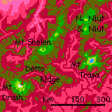
Day 6: south to Mount Trasa. You pass South Niut in the first hour; then the shared massif drops away into olive ridges in a misty red abyss.
Late in the day, the broad shoulder of Mt Trasa. The high point's 5.2 km high (17,000'), which you probably can't reach on the wing; but the crater rim sags several hundred meters (c. 1000'), and these lower stretches, plus good updraft on the west face, let you reach the rim. A caldera 16 km across (10 mi), with a central lake, deep indigo. Half a dozen ridges--old lava flows--radiate from the central peak. You can see hundreds of km west, east and south beyond the Tsi Range--lowland hills dotted with clouds like monster sheep, scarlet where sunlit, plum-purple in shadow.
Day 7: west and a bit south over a ruby gulf to a line of lesser cones, olive-bodied but green-capped, just reaching into the cooler zone. Ride this chain west; the tallest five peaks on Detto Ridge reach 4 km high (13,000'); as cool as you can hope for. Camp and rest on any.
Off to the northeast is Mt Shelen, a massive volcano even taller than Trasa, 5.3 km (17,500'). A few white streaks on its high, shady shoulder--the first winter snow you've seen.
Day 8: our way leads southwest. You can see your goal for hours beforehand--Mt Drash, some 5.8 km tall (19,000'), highest in the eastern Tsi. And it once was taller: its cone blew open on the north side, leaving an amphiteater with cliffs 1.5 kilometers high (5000'). By afternoon you've wheeled round the monster peak to the south face, revealing another world entirely: heavy snow. And it'll stay for months, through late spring. Drash isn't just the highest peak yet, you've crept a long way south--nearly 20° farther from the equator than your subtropical start on Lantrev Head.
Day 9: east and a bit north. Comfortable travel through green hills, never hotter than 35°C (95°F) and often just 30°C (86°F). Not too scenic after Drash, though.
Day 10: west. The mountains grow again--not volcanic now, great upthrust peaks, jagged, snowy, 5-6 km high (17-20,000'). You stick to the shadier south side of the range, a good 5 degrees cooler. Light showers--tentative winter rains. We're at 37° south now, out of the monsoon zone, in a more Mediterranean belt where most precipitation comes now, in winter.
Day 11: along the Western Tsi. Taller, if anything. Nearly Himalayan now.
To the south are vast fertile lands a bit like America's Great Lakes region--minus the snow of course. And bigger: the Somreth Lakes' total surface area is 50% more. But the basin's so wide the lakes are never more than mere gleams on the horizon. And those lowlands, though "temperate" by Capsican standards, are still too hot for you. We have the whole north to explore first. By then, in late winter, the lakelands will have cooled a bit more. Safer.
Day 12: for now, our way is north, over Root Pass. Peaks loom over you, well over 6 km high (20,000'). Hulking, massive--unlike Earth mountains, these heights were never shaped by ice. A high, strange, pale-green grassland, more fed by cloud than rain. You struggle to stay aloft in this thin air, nearly 5 km up (over 16,000'). Sorry; it's the only practical pass within days. Helpful hint: stay very low; you'll benefit from the ground effect (air under your wings has no way to escape; more lift). Of course this means dodging boulders.
Down. A few green trees appear. More. Open woods. Camp in their thin shade by a small creek, at 4.5 km up (14,800'); our highest so far. A clear, searing-cold night, dropping to an unbelievable 20°C (68°F). We're alone up here, for Capsicans crossing the pass aren't suicidal; though tired too, they all pushed hard and camped farther down, where it's cold but survivable with a good sleeping bag--30-35°C (86-95°F).
Day 13: you're soaring on an updraft on the southwest rim of Narai Plateau, looking down on the Psiya Desert. On your left, a high golden grassland, ending in great scarps below you, dropping in a giant's stair to pinkish dry savanna below to your right. Red and green strips paint the dark basaltic cliffs, with thin, wavering plumes of white--feathery waterfalls. Narai Plateau isn't Roraima, or its Capsican equivalent, the Pak Plateau--cloud forests above rain forests, rich in waterfalls because rich in water. Narai Plateau has seen a few thundershowers, but the lowlands haven't seen rain in months.
A long day north.
Near dusk, a change: to the east, cliffs as tall as Narai's blaze red in the sunset. Over a mile high.
Day 14: what is that? Another plateau? You could almost be looking across the Grand Canyon! If it had blood-red snakes of watercourses coiling over a broad floor of pink grassy carpet. But those facing cliffs lack the color of yours. Not the haze of distance--no red or green stripes of trees fed by falls. Why so little water? A map or a passing local will tell you--despite appearances, Tas Keel is knife-thin. Tall enough to force up clouds and rain, but most of what is snags just drains down the far side, back toward the sea it came from...
Day 15: Narai Plateau falls away into a monstrous gulf--Nesh Gorge. That Grand Canyon behind you was nothing! This is twice as deep: over 3 km (10,000') in spots. So cross with care! The heat down there generates lovely updrafts, but it's fatal for Terrans if you get stranded; even now in early winter it's 45°C (113°F) down by that sinuous river.
Days 16-17: northeast along the rim of Narai. Easy gliding: these cliffs generally face the morning sun and heat up fast. Updrafts til sundown!
Day 18: go 'inland' to avoid Ngoda Knot--peaks up to 7.5 km (24,000'). One has streaks of snow!
The Ngoda Hills go on for days, but for you they're a dead-end flyway.
Day 19: northwest along the great arc of the Kuna Mountains, imperceptibly veering west. Below, not desert now but savanna--at this low latitude, barely 22° south, more summer rain falls. Though the grass is pale and dusty; no recent rain.
At the northern tip of Narai Plateau, many locals peel off northeast, following the Rajiba Hills--the best flyway to Eastern Maisila. The hills march on into the sea as the Rajiba Islands, offering rest stops every few hours--for Capsicans. Don't follow; they're too low and hot for you to rest on, so you'd have to fly it all in one grueling marathon, 720 km (450 mi). Possibly survivable, I concede; but certainly torture.
Days 20-21: riding updrafts west, high above Re Savanna--rolling pink hills (dry rhodophyll grass) and lavender valleys (wetter, still growing) with narrow dusty-rose watercourses and occasonal bloody pond-clots, with rare rock outcrops breaking through the grass, brown as old scabs. It looks like a scuffed-up brain in a monster movie--the bad brain you really shouldn't transplant into your lovely creature. It'd end as badly as you will if you visit that off-color veldt. Don't. It's 50°C down there--122°F--rising to 60 (140!) on some mild winter afternoons.
Day 22: the rim of Narai Plateau breaks up into mesas and winding canyons--a hundred-mile bowl called Remah Amphitheater. Skirt the edge--tricky winds over those mesas! If you could see the airscape it'd be as complex as the landscape that generates it.
Stick to the true plateau rim as it retreats southwest, then west an hour to Yeb Keel--a straight ridge over 5 km high, jutting north 400 km (17,000' high, 250 miles long). We won't go far up Yeb--no point in heading out to Cape Hai or Remah Sound, fertile though the region is. It's a dead end, even for Capsicans with their vast flight radius; the Mainar Sea crossing here is a good thousand km (640 mi) with not one islet to rest on.
You're trying to cross Yeb Keel. Not easy--the air's thin up here--that is, 1.5 Earth atmospheres! With mere human muscles, that is thin to fly in. But you find a promising notch only 4.8 km high (15,750'); the prevailing winds slam up against the cliff face and lift you over.
Camp in a hanging valley a kilometer down; green woods along the creek, but treeless alps around and above. Below, red and green trees sparsely dot the long slope down to tumbled savanna foothills. As the sun sets, a fiery gold pool nestles in those hills--Lake Nakip. Beyond, the flats are desert broken only by streams off these highlands, all the way to the hundred-mile beaches of Nakip Bay. Unlike Re Savanna behind you, exposed to storms from the north, Nakip Desert is in a rainshadow--prevailing winds blow off the land most of the year; little rain comes off Narai Gulf.
Day 23: south a long day along the west rim of Narai Plateau, here quite imposing mountains--an extension of Yeb Keel. Slowly the pink dry-grass abyss on your right heaves into olive hills--the Kit Hills. Another spur of the Plateau, high enough to follow but leading nowhere but Nakip Bay--and at the rim they form a knot, with peaks over 6 km (20,000'). Time to veer inland! It's a lower, easier pass, and you ought to explore a bit of the plateau, despite that thin air.
Day 24: southeast across the plateau a day. Stony, but dry yellow grass with green sprouts; a recent rain. It's hard flying, without the constant updrafts of those cliffs on the plateau rim. And hot: a continental, high-altitude climate, warmer than you'd expect for nearly 4 km up (13,000'). My advice: follow a creek and break every hour to swim. The water's surprisingly cool: not snowmelt, not even now in winter, but from high up in the green zone.
In mid-afternoon a redrock gulf opens up, 25 km wide and 3 deep (15 mi, 10,000'): Oren Gorge. We came out where I hoped: the Elbow. Upstream the canyon runs due east to the horizon, but here it kinks southwest and runs out of sight. Camp here on the north rim.
Day 25: cross Oren Gorge. Head south and a bit east, staying above the elbow joint. Why? By the time you reach the southern, sun-facing wall, it's warm, forcing a solid updraft lifting you over the rim. Now we can head southwest. A long day. Again, although the river meanders, the canyon's straight overall. An ancient lava flow of softer material, with a lot of gas in it? The opposite of a typical lava dike. But surely a weak flow would form just one stratum, and Oren Gorge is two miles deep! More likely the stream took advantage of a deep crack through many layers (perhaps one like the fossae on Mars?), as Narai Plateau bulged under magmatic pressure. I'm not sure. But it's an odd place.
Day 26: skirt Vava Knot, with its Himalayan peaks. East over the Plateau? Even there, the passes hit 5.5 km (18,000'). Better I think to head west, a long winding way at waist-height. But at least the air won't thin out... In and out of hanging canyons--green meadows where waterfalls plummet into hotter zones--scattered red trees and lavender savanna.
At sunset, on the western horizon, the pale veldt deepens to a bloody strip edged in silver: a wooded delta where the Oren and Dorba Rivers almost meet on Narai Gulf. Camp on the shady southwest side of Vava Knot. A cool and pleasant 30°C (86°F) at 4.4 km, (14,500').
Day 27: southeast. A great river, silty, honey-amber, meanders below you on the right. By noon, a line of sunlit cliffs to the south. Slowly it nears; the south wall of Dorba Canyon, narrowing steadily til it's just 40 km away (25 mi). Spiral high as you can, and head across. Again, as in Oren Gorge, you'll lost altitude as you go, but updrafts around the sunlit cliffs will lift you back to the rim. Rest by a creek that shoots into space, a mare's tail that frays away into mist. Impossible to tell how deep a drop, for after a kilometer or two it's more a rain-squall than a waterfall.
Southwest. The wall bells out like a tuba, soon heading south.
A ridge cuts off the desert to the west: Dor Hook. You're heading up a narrowing side branch of Dorba Canyon. Over an hour or two, the floor rises to meet you. Camp in the pass between the base of Dor Hook and Narai Plateau.
Day 28: Over Dor Pass, south. A new gulf opens ahead--follow the east wall, the rim of Narai; Dor Hook is a dead end for you. Round a hundred-kilometer arc looking down on Dor Creek Amphitheater. It's the first stream not reaching Narai Gulf but feeding into the Elin River. Late in the afternoon, free of all things Dor-ish, you're back to riding an easy updraft over sunlit cliffs; green heights on your left, desert far below on your right. Find a creek--that'll take a while on this strip--and camp. Bloody red sunset; Elin Desert raises dust.
Day 29: steadily south. The lowlands on your right are harsher country than up around Yeb Keel. The Elin Desert's no coastal strip; walled in and rainshadowed by mountains on three sides, it's as hot as the Ralos Desert, and even drier. But up here on the Narai, temperatures remain tolerable; you're creeping toward the pole, and it's late winter. Still, the only place you find trees are along streams--modest creeks that leap over the edge and fray, feeding a fan of red trees and grass below, then collecting into rivulets that mostly evaporate before they reach the Elin River, the desert's only oasis of any size.
Day 30: Narai Plateau's rim breaks up. Canyons and mesas. You hop southeast.
Day 31: Elin Gorge, the subcontinent's biggest--though still small next to Shato and Sindra Canyons in central Chai, or Mariner Canyon and Noctis Labyrinthus on Mars.
Day 32: south along the Rai Mountains. As high as 7.3 km (24,000').
We're finally, unmistakably out of the subtropics. Snowcaps on many of these peaks, not just streaks--even on ones no more than 6 km tall!
Day 33: an unusually clear spell. East onto spur, just waist-high, 4.3 km (14,000'). That pale blue to the southeast, 110 km (70 mi) away, is not the sea but Lake Somreth, a freshwater lake bigger than Lakes Michigan and Huron combined (oh wait--they are. Same water level, unlike Superior, Ontario or Erie. Biggest freshwater lake in the world. Just unacknowledged.)
Day 34: on south into the labyrinth of lakes, mountains, craters, and coronae of Volia. Capsica's seasons are shorter than Earth's, just 70 days; winter's half done. But that'll work out well to the south; as spring stalks you, you head into colder latitudes where it could almost be Earth.

World Dream Bank homepage - Art gallery - New stuff - Introductory sampler, best dreams, best art - On dreamwork - Books
Indexes: Subject - Author - Date - Names - Places - Art media/styles
Titles: A - B - C - D - E - F - G - H - IJ - KL - M - NO - PQ - R - Sa-Sk - Sl-Sz - T - UV - WXYZ
Email: wdreamb@yahoo.com - Catalog of art, books, CDs - Behind the Curtain: FAQs, bio, site map - Kindred sites