Capsica's homepage, map, giant ref map, geography, gazetteer . More worlds? Planetocopia!
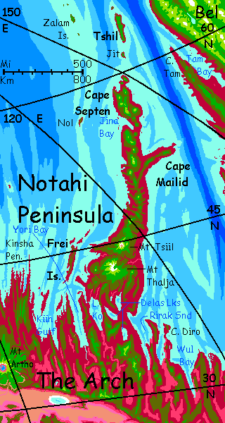
 Capsica: Notahi Peninsula
by Chris Wayan, 2013
This one's for you readers, who pestered me until I had to build it
Capsica: Notahi Peninsula
by Chris Wayan, 2013
This one's for you readers, who pestered me until I had to build it
INTRODUCTION
Notahi is a chain of great shield-volcanoes thrusting into the Arctic Sea--the trail of a hot spot deep in the mantle. Earth has a close analogue: if you drained the Pacific Ocean, the Hawaiian Islands and Emperor Seamount Chain would look much like this--a long bridge of stepping stones across the world. (Oh wait, I did drain it: see Hawaii exposed to its ankles in Siphonia.) Because the seas here on Capsica are so shallow, the whole height of these volcanoes is revealed; the tallest, Mt Thalja, reaches 12 km above sea level (40,000'!); third highest on the planet. Instead of mere islands neck deep in an ocean, a solid land-bridge spans half the Arctic Sea; and substantial islands, not mere atolls, lead over 1000 km beyond before getting swallowed in a subduction trench.
At the base of the peninsula, the young, active end of the chain, the volcanoes are tall and the land is wide and fertile. Food is plentiful--growth is explosive and lush during the light months.
As we proceed northeast, the climate cools steadily. True, the peaks are lower. For Terrans, who prefer the cool weather on volcanic shoulders, the journey is comfortable--you descend to warm up, or climb to cool. But Capsican travelers hug the coasts from the start, and start shivering as temperatures drop past 35-40°C (95-104°F). As the polar chill worsens they can't descend into their comfort zone--by now it's far underground! Up near Notahi's tip, it's hard to maintain a body temperature of 70°C (158°F!). The Zalam Islands, the northernmost of Notahi outliers, are right on the Arctic Circle. Summers are Caribbean, but the sun briefly stays below the horizon in midwinter; some years see frost at sea level.
It may look comical to Terran tourists enjoying the relief from the usual heat, but the locals here, who have long fluffy fur even for Capsicans, wear heavy fur cloaks layered over that, grounding them till the cold breaks. Capsicans hate turning themselves into chubby flightless penguins, but it's that or die.
NOHAA, NOTAHI'S PRIVILEGED TWIN
Notahi has a geological twin, the Nohaa. Similar in size, Nohaa is an island not a peninsula, and the eroded islands off its northern tip extend all the way across the Arctic Sea, while Notahi skirts the Arctic's edge. As a result, Nohaa's a short cut between hemispheres, getting far more traffic. Not an easy flyway, but a major one.
Poor Notahi! Just as large and fertile, it's a shortcut only for travelers between the east-central part of the Arch and the poor and remote northern shore of the continent of Bel. Capsican news and innovation spreads via fliers, not by ship as was true on Earth for millennia; here, it's major flyways that tend to be more culturally advanced. And Notahi just isn't.

World Dream Bank homepage - Art gallery - New stuff - Introductory sampler, best dreams, best art - On dreamwork - Books
Indexes: Subject - Author - Date - Names - Places - Art media/styles
Titles: A - B - C - D - E - F - G - H - IJ - KL - M - NO - PQ - R - Sa-Sk - Sl-Sz - T - UV - WXYZ
Email: wdreamb@yahoo.com - Catalog of art, books, CDs - Behind the Curtain: FAQs, bio, site map - Kindred sites