Capsica's homepage, map, giant ref map, geography, gazetteer . More worlds? Planetocopia!
 Capsica: Ri Kshen Isles
by Chris Wayan, 2012
Capsica: Ri Kshen Isles
by Chris Wayan, 2012
Introduction - Skia: Mt Lonat, Authenticity, Deserts, Fossae - Kitto - Ling - Lesser Isles - Drowned Coronas
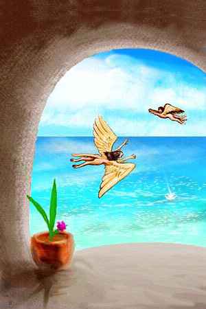
Capsicans consider the Ri Kshen Isles rich and lovely--a warm maritime climate, forests full of fruit on the rainy side, open meadows for grazing on the sunny side, shallow bays with rich fisheries all around. The climate's quite Hawai'ian (to the locals; we'd find it a furnace).
The Ri Kshens are a bit of a dead end. They lie not far off the huge, rich subcontinent of Maisila--just a couple of hours as the Capsican flies--but the flyways to Fulisse or the Tabaska Isles or The Eel are another matter--all many hours over deep water. By no means impassible, but hard work and a little risk (for you in your rented wings, make that a LOT of risk). The strait to Maisila is only a third as wide, so fliers mostly consider the Ri Kshens mere satellites of Maisila--and a dead-end to ignore.
This bywayness has shaped Ri Kshen society: in a word, insular. Like Maisilan culture, but more formal, traditional--it's like ancient Hawai'i, that deeply isolated chain overlooked by humanity until a mere millennium ago and culturally isolated for centuries more.
Intro - Skia : Mt Lonat, Authenticity, Deserts, Fossae - Kitto - Ling - Lesser Isles - Drowned Coronas
The largest of the Ri Kshens, Skia is nearly 800 km long and 600 wide (500 by 375 mi). It's like a huge lowercase 'n', curving around a broad southern gulf, Thapta Bay. Most of the n's stem and the outer, northerly shore of the curve are rainforested. But the woods open out on the lee side, facing the sun. Meadows and scrub; around Thapta Bay, this thins to true desert.
Intro - Skia: Mt Lonat , Authenticity, Deserts, Fossae - Kitto - Ling - Lesser Isles - Drowned Coronas
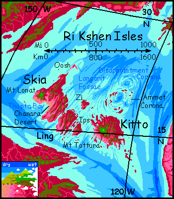
Mt Lonat in western Skia is the second highest peak in the islands at 3700 m (12,100). Though it's a shield volcano, Lonat's windward flanks are quite steep: erosion and dissection from heavy rains have sculpted the slope extensively; rain- and cloudforest cling to these ridges.
The south and west are more intact; also drier. Below sparse alps and thin forest there's just scrub, then the Kortin Desert out to the coast--a microdesert, but quite adequate to bake Terran visitors to death. The Kortin's a painted desert as scenic as Haleakala's caldera on Kauai, but tourists flying in from Maisila are emphatically warned: do NOT land here! Don't even swoop in for a close look--the prevailing winds descend the mountain, creating downdrafts that can ground you in terrain so hot it can burn at a touch. You won't get airborne again--or live long enough for rescue.
So I don't care how tired you are after the long crossing from Maisila--take an extra hour, swing round Mt Lonat's flank to the northeast windward side, and ride the updrafts to the summit, or camp on a tree-shaded ridge on the north shoulder well above 2500 m (8,000'). This high patch is just a few miles across, but it's the only part of Skia you'll sleep well in.
Intro - Skia: Mt Lonat, Authenticity , Deserts, Fossae - Kitto - Ling - Lesser Isles - Drowned Coronas
Just half an hour's glide north is Mountain Hall, also at 2500 m (8000'), the only drama-temple in Ri Kshen that's cool enough for you to enjoy the ritual theater.
Yes, some tourguides have claimed the Mountain Hall costumes are inauthentic pageantry: over-modest and elaborate, in contrast to the nudity (just feathermask, anklets and wristlets) in the all-native lowland temples too hot for you to visit. These critics are missing the point. Mountain Hall dancers are neither prudish nor puffing up the traditional plays into empty tourist pageantry--they're just bundling up against that highland chill. It gets down to 30-35°C (86-95°F), and for a Capsican with a blood temperature of 65°C (149°F), that's roughly like performing in an icerink. You can see why the Mountain Temple trance-dancers don't strip down to their pelts. Ri Kshenians are traditionalists, not masochists!
So accept the feather robes as a legitimate local variant, and focus on the songs. They're worth it. Oh those microtones! As weird as any Tahitian choir.
Intro - Skia: Mt Lonat, Authenticity, Chanara Desert , Fossae - Kitto - Ling - Lesser Isles - Drowned Coronas
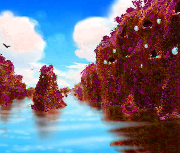
Kortin Desert is tiny, but the dry shores of Thapta Bay run a good 200 km (125 mi)--the Chanara Desert. Except for streambanks it's harsh country--lava flows unsoftened by rains. Tan is the color on the map, but it's really black and red.
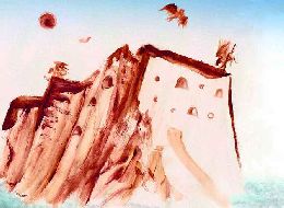
Some creeks do run down from the hills, carving canyons in the soft rock. Near the sea, where these creeks slow and meander, widening their canyons, irrigation is practical. Being fliers, Capsicans dig into the lava walls to create whole cliff-villages with balconies opening on air. Fine views, no need for ladders, and it's safer than living on canyon floors--they're prone to summer floods.
Not that you can visit these lovely cliff-pueblos. The rock does shelter them from the sun's heat, but just like Earth, the temperature underground tends to be near the regional year-round average: in Skia's lowlands, around 55°C (131°F).
A ten-kilometer fringe of dry savanna surrounds the true desert--a borderzone of lavender grasses during the sparse rains of orbital, bleaching to a silver sea in the dry winds of winter. There will be creatures eating that grass--savannas can feed a lot of animals per square kilometer--but will the Capsicans be herders? or the herd?
Intro - Skia: Mt Lonat, Authenticity, Deserts, The Langarit Fossae - Kitto - Ling - Lesser Isles - Drowned Coronas
Lava flows from Mt Lonat and the hundred other vents of the Ri Kshens built up the islands on a rather strange, shallow sea floor--a small triangular plate with long winding cracks and ridges called fossae running northeast-southwest. These cracks, the Langarit Fossae, run parallel to the trench near Fulisse and perpendicular to the trench to the south off Maisila, hinting this platelet is under strain. Is it bulging and/or stretching? Mars has many fossae around the Tharsis Bulge, where its largest volcanoes cluster; Venus has several examples of smaller sinuous fossae-fields quite reminiscent of Langarit, many near "sea level" too--like the Brynhild Fossae of Alpha, or the Perunitsa and Khosedem Fossae of eastern Phoebe, or the Oma Fossae of southern Hathor (okay, I used the same illustration for all of them...)
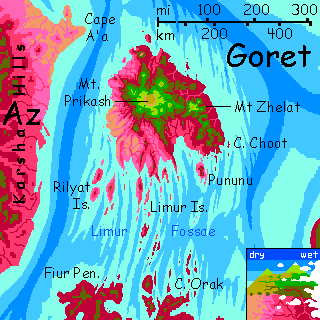
Whatever their cause, these fossae aren't unique. Halfway across the Outer Hemisphere, east of Az, is a second platelet of fossae, ridges and another isle the size of Skia or Kitto, though instead of a corona Goret is more like Hawaii: huge shield volcanoes. And far to the south, the Nipsak Sea has quite an extensive fossa-field, though they're mostly barren; little rain.
Terran mariners might have taken advantage of the fossae as safe ship-channels, but they wouldn't have seen the full extent of the pattern until they'd developed flight--or really good cartographers. Not so in Ri Kshen; the Langarit Fossae are obvious to folk on the wing--turquoise on purple and brown in the shallowest water, where Capsican equivalents of kelp forests flourish; azure on turquoise in slightly deeper water, where the cliffwalls of the fossae form spectacular rock gardens full of lurid-colored sea life (though not corals; most Capsican seas are too hot to hold much calcium in solution, so hot-water cousins of chitin and cartilage are the skeletons of choice.)
I wouldn't dive here; these seas are hotter than you are! Not enough to scald, but enough to sting a bit. Yes, your skin will adjust and it will be hot and relaxing and all, but think about it. In a hot tub you don't exercise, fully immerse yourself, or stay too long (if you're smart); after an hour diving in Tub Capsica you'd collapse from fever. And thirst! "Water, water everywhere, and never a drop to drink." And salt depletion! You're sweating brine into hotter brine--not an effective cooling technique, but you didn't evolve for hot water, did you? (My apologies to my extremophilic readers; my humanism is showing again. The era I write in, sigh...) One final blow to the head: Capsica's air pressure's so high you'd face nitrogen narcosis just 20 meters down. Rapture of the Shallows!
No single factor will kill you on the spot, but combined they guarantee trouble will creep up on you and pounce.
So leave the lovely pseudocoral gardens to native Capsican divers. If you're feeling brave, take a ride in a glass-bottom boat under a canopy, draped in a wet blanket, stared at by Capsican grandmas and young parents with nurslings. Even that's so hot (55-60°C, 131-140°F) it's likely to kill you. Sorry. You don't belong down on the coast.
Intro - Skia: Mt Lonat, Authenticity, Deserts, Fossae - Kitto - Ling - Lesser Isles - Drowned Coronas
Kitto is that crab-shaped eastern isle as big as a tropical Ireland. Though with all its volcanoes I should probably compare it to Iceland. It's closer to the equator than Skia, but that makes no difference in heat, not to Terrans--fatal is fatal. It does affect the rain-patterns--the wet season is longer and rainier. Yes, rainforest is hard to tell from wetter rainforest, but the difference is visible on the dry side: it opens to savanna, but no bare ground, no true desert patches.
Kitto's savanna is also nourished by a quirk of geology. The central hills, like Skia's, are modest. Mt Tottura tops 3900 m (12,800'), the tallest peak in the Islands; but most ridges are just 1000-1500 m (3300-5000'). Even that's enough to cast a rainshadow at this latitude, but these ridges have eroded parallel to the underlying fossae (are they small faults, is there lateral slippage eventually cracking the lava flows above them?) That's also parallel to the prevailing winds; these valleys lead storms right through! In contrast, Skia's great curve of hills do have similar breaks, but the hills are higher and simply more extensive, exhausting most storms--unfortunately for the desert downwind.
Oh well, it's all academic. The rain's good for the land but bad for you; the added humidity, on top of the heat, means you can't visit anything on Kitto but the head and shoulders of Mt Tottura. Lowland Kitto's just too muggy.
Intro - Skia: Mt Lonat, Authenticity, Deserts, Fossae - Kitto - Ling - Lesser Isles - Drowned Coronas
Between Skia and Kitto are hundreds of islands, all low and hot. Ling, by far the largest, is a little more equatorial than Skia; rainy in the north and in the high central ridges opening to savanna on the south shore, but never desert.
Only a few of Ling's central ridges top 2 km (6600'); the highest, at 2.3 km (7500') could, I guess, be used as a way station for Terran tourists trying to fly from Skia to Kitto, but I wouldn't recommend it. Even in winter they're oppressively hot, around 40°C (104°F).
It's a shame Ling's thermally inaccessible; the north shore has a fascinating series of tropical 'fjords' where the Langarit Fossae run up on shore, in little cliffwalled sounds. Capsican villages cling and burrow into the cliff walls; all of it overrun with jungle flowers and vines--magenta and purple, with flowers in yellow, white, blue and (logical, but funny-looking to Terrans) bright green. The point of a flower, after all, is to stand out. Green down here in the tropics is an exotic color, suitable for attracting birds, insects and local gardeners.
Yes, those round shiny things are windows; yes, Capsicans have glass. They never need it here to keep out the cold; but storm winds can get very high. You wouldn't want glass windows in a grass hut or wood-frame house; they'd crack as the frame gave way; but anchored in stone, such windows keep things dry even in a typhoon.
Intro - Skia: Mt Lonat, Authenticity, Deserts, Fossae - Kitto - Ling - The Lesser Isles: Zi, Ips, Oosh - Drowned Coronas
The smaller isles between Skia and Kitto are even lower than Ling, hence hotter.
Zi is much like northern Skia. Not surprising--the same latitude, and upwind of it. Entirely off limits to you.
Ips, a few degrees closer to the equator, is rainier; mostly covered in ruby forest. Entirely off limits to you.
Are you sensing a theme here on tropical paradise?
North of Skia lies lonely Oosh. Oosh is close to the latitude of Hawai'i, where low ground gets less rain, unless hills force clouds up and wring extra moisture from them.
Oosh has quite scenic cliffs--it's basically a ridge between fossae--dramatic, but not high enough to generate rain. Inland (not that Oosh is ever more than a few miles wide) the land is dry and scrubby; no one lives there, or even goes there much.
Ooshans all live in fishing villages carved into the soft seacliffs with entrances on the windward side, so updrafts lift these fliers from sea level back to their doorsteps. These artificial caverns have rain-hoarding rock cisterns; Oosh has no surface streams at all.
Intro - Skia - Mt Lonat - Authenticity - Desert - The Fossae - Kitto - Ling - Lesser Isles - Two Drowned Coronas
Ridges between fossae sometimes rise above sea level, forming narrow islands with long cliffs. North of Kitto, these curl into a radial pattern around a wide central hole: Ammet Corona. Islands and cracks are concentric; here the fractured crust is apparently being sucked in--a corona may be like a motionless hotspot, or something like the opposite of a hotspot. Light bits of crust and the higher ridges between fossae compress, splinter, and heap up into huge craterlike formation. Picture it like a slow-motion version of the accretion disk around a singularity.
Such coronae are common on Venus and not that rare on Capsica; far western Chai has examples of three types of coronae: convex, concave like Ammet, and chaotic like... well, the Ri Kshens. Or Iceland. Really, if you transplanted Iceland to Venus, once the ice melted off the land would look quite coronish. Coronoid? Anyway, Earth has at least one corona. We just didn't see Iceland as a type till we'd mapped Venus and seen a hundred iceless Icelands... As TS Eliot clumsily put it: "We shall not cease from exploration. And the end of all our exploring will be to arrive where we started and know the place for the first time."
North of Ammet's is a second lower ring, never more than reefs, though the central "lagoon" is just as big and deep: Disappointment Corona. The name is inevitable. Tired fliers from the Tabaska Isles 750 km (450 mi) to the northeast would dearly love a spot to rest before proceeding on to Ri Kshen, but the reefs don't quite break the surface anywhere. Life abounds--excellent fishing--but no rest, shade, fresh water, fresh fruit. For once, a region that native Capsicans find as much of a frustrating tease as Terrans do all over...

World Dream Bank homepage - Art gallery - New stuff - Introductory sampler, best dreams, best art - On dreamwork - Books
Indexes: Subject - Author - Date - Names - Places - Art media/styles
Titles: A - B - C - D - E - F - G - H - IJ - KL - M - NO - PQ - R - Sa-Sk - Sl-Sz - T - UV - WXYZ
Email: wdreamb@yahoo.com - Catalog of art, books, CDs - Behind the Curtain: FAQs, bio, site map - Kindred sites