Capsica's homepage, map, giant ref map, geography, gazetteer . More worlds? Planetocopia!
 Capsica: Antarctic Sea
by Chris Wayan, 2010-2011
This one's for you readers, who pestered me until I had to build it
Capsica: Antarctic Sea
by Chris Wayan, 2010-2011
This one's for you readers, who pestered me until I had to build it
Introduction - Botany - Zoology - Hithluma - Nmm Strait - Into the Arch - Green Coast - Dragonspine - Risks - Back to the Crunch
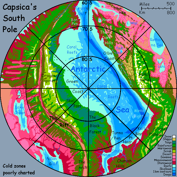 Geographically, Capsica's south pole resembles Earth's north pole: a nearly landlocked sea with cold, marginal, but living lands around it. Of course, the similarity is recent and temporary; ten thousand years ago, our Arctic was utterly different, a much smaller sea ringed with huge ice domes; next to no life. Unless humans keep pouring carbon dioxide into the air, it will be that again, in a few thousand years; the Ice Age never ended. We're just in an interglacial.
Of course "cold", on torrid Capsica, means something different: basically, "Earthlike". We'd call the temperatures on the Antarctic coasts subtropical to temperate; even the highlands are temperate, with some winter snow in the higher mountains, even a few small glaciers, but nothing like our Antarctica or Greenland, or even Iceland. Not even Ohio.
The trouble is, Capsican life hasn't evolved for snow. For natives, this mild polar region--the only one most Terrans would find bearable--is frightening, alien, and truly dangerous.
Intro - Botany - Zoology - Hithluma - Nmm Strait - Into the Arch - Green Coast - Dragonspine - Risks - Back to the Crunch
Most Capsican vegetation is reddish or purplish and uses a light-capturing molecule we'll call rhodophyll. It's adapted to a temperature range of 30-80°C (86-177°F). These rhodophores predominate in the lowlands and low latitudes; in highlands and near the poles the only plants that flourish are green, using "chlorophyll" (well, a very similar squarish molecule using a magnesium atom that absorbs reddish light but reflects green; what else can I call it?)
Ecologically, a second tier of strange-colored, cold-adapted plants should be no surprise. Remember our own cold-adapted evergreens with their dark needles and antifreeze. Infrared satellite photos show ordinary vegetation as bright red, but evergreen forests as black. Capsica's palette just happens to show a similar clash in visible light--plum to purple in hot zones (fading to lavender grasslands in dry regions), and quite Earthlike greens in cold wet zones and golds in cold dry regions. On most of the planet, that kind of cold is found only high up. These polar coasts are about the only place on Capsica where green plants march down to the sea.
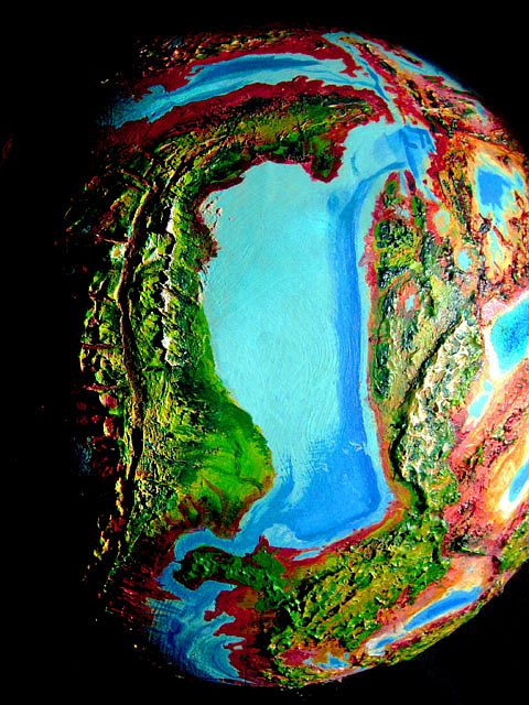
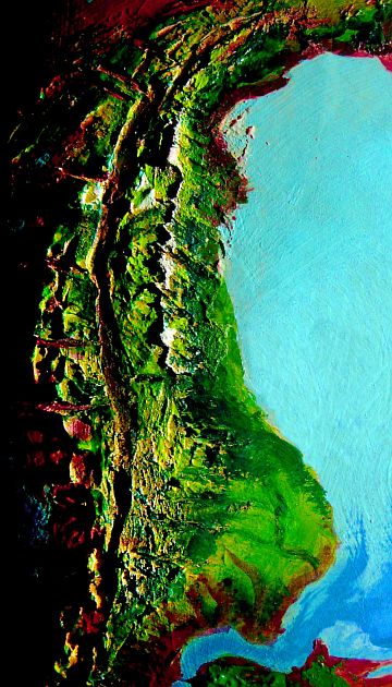
Here's a high-orbital photo of the region. The Antarctic Sea is dead center, The Dragonspine Range is to the left, and Hithluma Plateau is to the right.
Zoology - Intro - Botany - Hithluma - Nmm Strait - Into the Arch - Green Coast - Dragonspine - Risks - Back to the Crunch
Though Capsica's poles seem balmy to us, animal life here evolved in high temperatures, with enzymes to match. The Capsican word for exothermic is just like colloquial English: "cold-blooded". But they mean blood that merely matches the environment; on average, hotter than human! The key word here is "average". Just as on Earth, such creatures are sluggish and generally less sophisticated, for all but the largest must endure what for us would be severe chills and fevers. Not friendly conditions for running a high-end brain!
Endothermic or "warm-blooded" here means what on Earth we'd have to call hot-blooded: typical body temperatures are around 70° C/158°F. Over most of Capsica, this causes no problems, but here in the polar regions, and especially in the uplands, animals must insulate heavily or die. But it takes a lot of food to grow fat and fur and to sustain ovenlike temperatures inside. Even so, this is evolutionarily easier than retooling a million enzymes--Capsican hot-blooded life is too well adapted for the vast rhodophyll zone.
Worse yet, in the polar highlands, the air thins to only 1.2-1.8 atmospheres--as low as half the pressure at sea level. Flight becomes harder; large animals (and upland beasties are--it helps conserve heat) must settle for an bizarre, clumsy, energy-hungry strategy called "walking". Or they don't settle at all; diversity plummets in the highlands, and no large fliers at all live here. We'd see these uplands as quite French or at most English, with distinct winters but only occasional snow; but to native Capsicans they're as harsh as Siberia... plus Tibetan thin air.
So the commonest animal in these weird polar woods is the licha, a grazer with ridiculously thick fur: like a deer with a Persian cat-coat and silly vestigial wings, like a costume from a Nativity play confusing the asses and the angels. Licha are common, but you won't see many; they're wary.
They need to be. I haven't yet deduced if the Antarctic's top predator resembles the wolf, puma or Siberian tiger--but licha will be their prime target, and in these woods hunting will be by stealth.
In opener grasslands it's a different story. Hiding's pointless here, so you'll see great herds of ubirak, larger hoofed ruminants relying on fat and football-huddles to get them through the dark storms of winter and skulking predators. Animals the size of a cow retain heat well; they're shaggy in winter, but not furballs like licha! Aside from the wings (used to flap warnings) they seem a sort of buffalo-moose hybrid. Quite Terran; but is that surprising, given such Terran conditions?
One difference: "what big eyes you have!" Unlike Earth's grazers, who don't venture deep into the polar zone, ubirak and licha get within five degrees of the pole, where winter darkness can last months. On the rest of Capsica, three moons keep the nights deep blue, not black; but during polar winters, storm clouds and the bulge of the planet often hide all the moons, too. So licha and ubirak have night vision rivaling a cat's! And need to. Attrition from predators is severe in winter; the dark lets hunters creep in close. Plants stop growing; many die. Famine times! Winters here are hard and precarious, quite without ice.
Intro - Botany - Zoology - Hithluma - Nmm Strait - Into the Arch - Green Coast - Dragonspine - Risks - Back to the Crunch
Yay! This is one of the few regions of Capsica that offworlders can tour with any safety. It's also one of the few tours we can conduct in summer, and that's lucky, since you'll need the light. We'll start in the quite Terran upland of Hithluma, on the right side of the map, and try to circle the Antarctic Sea without getting you killed.
Hithluma is a high plateau analogous to a Terran continent. Like Venus and Mars, Capsica has few continental platforms with clear, sharp drop-offs--our deep seas shaped most of those! Still, there are some, especially here in the hemisphere called the Crunch--Hithluma's the southern tip of that huge complex of mashed-together miniplates. Rocks here are lighter: sedimentary and metamorphic, with of course volcanic intrusions--ubiquitous on busy Capsica. But overall, Hithluma's like a balsa raft floating on the great Capsican sea of dense basalt.
Hithluma's edge is emphatic; on Earth, the Hithluma Mountains would be a formidable coastal range. But Capsica's drier, so it's an inland front-range much like the Himalaya. And nearly as high--passes at 4-5 km (13-16,500') and peaks up to 8 km (well over 26,000'). These mountains vie for the medal of coldest spot on Capsica. Not quite the Alps; the Sierra Nevada, though. Winter snowpacks can be substantial, with temperatures below freezing for days on end. If you can call them days! Perpetual dawn is all. In deep winter, over much of the plateau, the sun never quite rises; we're past the Antarctic Circle. Even a few glaciers hide in high, deep cracks. Only a few; now, in summer, the sun wheels round the horizon, never setting, always trying a new angle, poking its fiery nose in; poleward slopes don't stay shady the way they do at lower latitudes.
Below the drop-off, the lowlands are a hazy mass of olive hills; red arteries of valleys, greener heights.
A few days, and the dusky-rose horizon starts to blue to a Terran color: the sea. Slowly the great wedge of lowland narrows, until Hithluma rears directly above the ocean; a twenty-mile slope. Well, twenty miles above water--from the deep azure close in to shore, it's clear the dropoff continues undersea. A subduction trench miles deep runs offshore: the probable source of the Hithlumas.
Down you dive, like a falcon, air screaming in your ears....
Intro - Botany - Zoology - Hithluma - Nmm Strait - Into the Arch - Green Coast - Dragonspine - Risks - Back to the Crunch
After cool Hithluma, the Antarctic shore feels balmy--nearly tropical. Not too rainy--cold dry air falls at the pole and blows outward, in steady sea-winds that paradoxically don't carry that much moisture. Only a day or two back they were in the stratosphere; not enough time to pick up much water from the sea. Still, they aren't the freeze-drying blasts of Earth's polar zones, where the winds are so cold they can't pick up moisture. Summers here get dry, with a few mild rains and many fogs; in winter, polar storms sweep through. Not our white blizzards, but black gales of driving, sleety, bonechilling rain. "It was a dark and stormy night"--for months.
In Earth's Arctic, winter is the time to travel, despite the dark. Ice makes an easier road than summer's bogs and treacherous waters. Not so on Capsica. The few polar natives are migratory fliers; they come here now, herding and harvesting in summer when skies are often clear and the endless low light makes travel easier.
You head almost due north the next day along a straight shore feathered in rust and green, until a wall of hills rises ahead: the coast turns east. You camp here in Minto Bight. Hard to sleep though; the sun never sets. Blearily, you head east for three sleeps-and-wakes, along a coast dappled plum with distinctly less green. We're on the fringe of the Antarctic here; that unnatural corpse-green chill has almost faded back to Capsica's normal ruby.
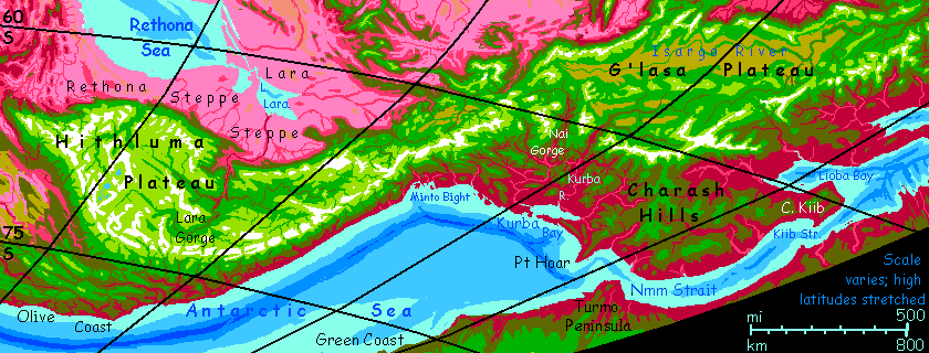
The second day, the shore narrows to a maroon strip between a long sound or bay and the sea: Kurba Sound. Except for the sumptuous maroon of the conifers, this could be Puget Sound before Seattle; you see few signs of settlement, for to Capsicans this mild misty land is still Siberia or Tierra del Fuego. The mouth is just a few kilometers wide; by now you cross it without hesitation. Flap on east!
Across the bay to the north you see red flats, then olive hills occasionally capped in green--the Charash Hills. None are white-tipped as in Hithluma. The snows are there, but they've retreated just over the horizon: the G'lasa Highlands. G'lasa is nearly as high as Hithluma in places but more broken; and since it's further from the pole, only the mountains see heavy winter snows; the plateaus between are windswept prairies more Texas than Norway. Let's stay down on the shore where the swimming is nice; you've seen one Tibet already.
A day later, you pass Hoar Point, a hilly cape about 100 km long and wide, marking one end of the long Antarctic Sea; we've come halfway round.
For much of a day you curve along the shore of Nmm Strait, linking the Antarctic with the world-sea to the north. When you camp, the beach faces due south; the far shore's invisible from our beach camp.
Rest most of a day. Last chance to avoid the Strait! You could just flap north and explore G'lasa and the Crunch beyond.
No? Before dawn (theoretically, at least; the stubborn summer sun's swung low to your left, over the sparkling sea, where it won't glare in your eyes) you tackle the most dangerous stretch so far: head directly out to sea, back toward the Pole. Take this slow and steady; it's 200 km (125 mi) to the far side of Nmm Strait. Several hours' flying, and no Diomedes Islands. How are you Bering up?
Sorry. I'm joking to blow off nervousness; if you falter here, you drown, and all it takes is a little carelessness in your preflight inspection: a bit of chafing can turn to agony in a few hours with no hope of relief. This is the first day you face real danger, though not the last of course. Cheer up, it's special: Nmm is one of the few spots on Capsica where, if you die, you'll die of hypothermia.
Intro - Botany - Zoology - Hithluma - Nmm Strait - Into the Arch - Green Coast - Dragonspine - Risks - Back to the Crunch
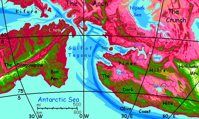
With luck, a low dusky-purple shore eventually creeps into view. You land on the gritty beach, exhausted. Congratulations! You've left one quasi-continent, the Crunch, and made it to a new one: the Arch. It's a world-girdling rift zone where new crust spreads--analogous to Earth's mid-sea rifts and ridges, but exposed on Capsica.
The Arch is a land of rugged ridges and fracture zones, with cliffs 1-2 km tall in many places, many at right angles (the shearing forces tend to generate straight lines and even grids of mesas and canyons, like the ruins of a Manhattan built by Godzillas); much of it's boldly bicolored, as the ridgetops rise out of rhodophyll country into the chlorophyll zone. Maroon "streets", cliffs streaked black with moss, white with rills, capped in green... rooftop gardens on the tenements of the gods.
But all that's anticipation. These coastal lowlands around Nmm Strait are unusually placid for the Arch: low hills clad in red and plum-purple forests, with scattered pink meadows and cyan lakes. Inland, the heights cool to olive browns: mixed trees. Chlorophyll pioneers.
A couple of days south through the hills of the Turmo Peninsula and southwest along the coast, rhodophyll's reign fades and chlorophyll creeps downward. Here winding valleys with riverine woods form plum-colored tentacles below olive slopes and pale green, even gold grassy hills--a single kilometer above sea level, the rhodophores give up. Winter winds near freezing? Just unbearable!
We're now at 75° south. It's summer. In the endless afternoon, it warms to a feeble 35°C (95°F).
The savage Antarctic.
Intro - Botany - Zoology - Hithluma - Nmm Strait - Into the Arch - The Green Coast - Dragonspine - Risks - Back to the Crunch
Here the coast bends due south for a full day. By the time it starts curving eastward again (and will run east for many days) we're past 80°, the polarest land on Capsica. The Green Coast--and it really is a sober dark green. Utterly Terran. "Pine" forests! Here and here alone on Capsica, many winter nights are frosty and snow can fall--at sea level. In hard years, a little sea ice even washes ashore to melt. Brrr! Considering that just touching frozen water will instantly blister most Capsicans, this isn't to be taken lightly; it's why you haven't seen anyone for days. A few migrants, herders, herbalists, loggers and miners visit these endless Nordic lands in summer, but Capsicans find them haunted--alien.
Offshore is a bizarre sight, too: unmistakable coral reefs. The Antarctic Sea is mild enough to carry much higher levels of dissolved minerals than the bath-hot equatorial Ocean, which can't hold them in solution for reef-building organisms. The low latitudes have it nearly as hard as our freshwater beasties. But the local sea life glories in that luscious calcium and grows shells and coral equivalents like mad. These reefs extend out for miles, a maze bigger than our Great Barrier Reef. And yet alone; it's unique in this hemisphere.
Shallows in the Arctic Sea have just as extensive though more scattered reefs that look much the same; but the two complexes have almost no species in common. The tropics are a fatal barrier.
Intro - Botany - Zoology - Touring - Hithluma - Nmm Strait - Into the Arch - Green Coast - Dragonspine - Risks - Back to the Crunch
Inland, faint and far, a glimmer of white. A legendary terror to the locals! But we're Terrans, sculpted by ages of ice; let's bank left and follow that suspiciously milky river up into the unnaturally green hills toward that white gleam.
Inland, as we climb, it gets colder, deadlier to native life. The forests thin and trees grow patchy. Ahead lie alpine meadows, then barrens. Snowy peaks glisten. The Dragonspine! Not so high as Hithluma, but then we're twice as close to the pole. Even now, in high summer, the temperature here in Skel Pass is a chilling 24°C (75°F), and late snow streaks the deeper avalanche-chutes on mountain-shoulders above us.
Try not to shiver--in laughter. For Capsicans, the danger's real.
Besides, you face your own risks. You can barely fly here, 2.5 km up (8000'). Work at it! Skim the alpine flats and scrub-pine terraces to your right. Stay low. You'll get a boost from the 'ground effect'--a bubble of high-pressure air develops between your wings and the ground. But what you save in muscle work, you lose in nervous energy; you have to dodge trees and boulders.
An hour of nervous, exhausting flight later, the ground effect disappears. So does the ground. A moment of terror, then you remember wings. You're floating, a sudden parasailor, in an updraft on the face of a vast cliff. Ahead is another, black and brick and green, white-plumed with waterfalls a kilometer high. The gulf below you is a maroon Yosemite, a great bloody gash perhaps 5 km wide (3 mi) and at least 1.5 km deep (5000'). We could have followed this easier, dense-air flyway cutting through the Dragonspine, but then I wouldn't have gotten to see you panic.
But now let's use the flyway--you've earned it. Wheel left and just ride the winds off the Pole as they rise up the canyon. This is one of the fracture zones I mentioned, a major one. Every thousand km or so (often less)--Capsica's crust fractures like this. The Rift constantly spreads new crust, but the speed varies a lot in different stretches. These fractures are the boundaries between speedlanes. If the Rift curves, these lanes may be squeezing together or spreading, too...
Bless Capsica's relative dryness, for exposing all this deep-sea crustal drama--just as much scenic verticality as that mad sculptor Ice gave Earth! Drought giveth what Warmth taketh away. One could argue for a geographic principle, call it the Bioscenic Law of Conservation of Verticality: "Only tectonically active worlds will circulate minerals well enough to sustain multicellular life, so all inhabited worlds will be scenic! Climate only determines where the scenery is."
But I'm probably wrong. Our sample's too small. Consider: a big, wet world (oh. let's call it Lyr) might drown most or all its land. Not much scenery then, unless you have sonar-senses and either gills or mighty good lungs.
Anyway, scenic alert. The Dragonspine isn't called that on a whim. It's going to be spectacularly vertical for a while.
For example: if this were Earth, and an ice-carved canyon, then as we head upstream it'd eventually split and shrink--or end abruptly in a cirque. But this fracture-canyon cuts right through the range, straight and arrogant as a Roman roadcut, until... the world opens out. On the distant horizon, another cliff and range--the far side of the Rift. But left and right, between cloudcapped, ice-horned mountains, is the Rift itself. Worldwide, the rift valley is always drier than the lands around it; by definition, a rift has mountains on both sides, and they snag most of the local rains. This stretch, even at 72° S, is no exception. In the middle of Norway, we're suddenly in Ethiopia: the rift floor is rusty with rhodophores along watercourses, blotchy lavender grasslands, tawny dry mesas.
Intro - Botany - Zoology - Hithluma - Nmm Strait - Into the Arch - Green Coast - Dragonspine - Rift Risks - Back to the Crunch
For a week or more we fly down this interesting if somewhat dangerous land-in-the-making. Volcanoes. Mudpots. Alkali lakes. Hotsprings and whole lakes luridly stained by trillions of bacteria.
Better stick to snowmelt from the highlands for drinking water. You'll quit vomiting by tomorrow, probably.
Oh, and swimming. Sorry I didn't speak up sooner. Those chemical burns will heal in no time.
After weeks? It's time to cross the Antarctic Sea. Two flyways:
Still, you'll face worse as you explore Capsica. Much, much worse. Might as well get a mild taste of the thermal hazards you face elsewhere. Kela Strait's the lowest latitude on this tour--and it's still 57° south.
Contemplate the equator, before you whine.
Intro - Botany - Zoology - Touring - Hithluma - Nmm Strait - Into the Arch - Green Coast - Dragonspine - Risks - Back to the Crunch
Full circle through the wide lowlands and lake country below Hithluma. Lavender grass-valleys with red veins along creeks; green on shadier hill-slopes. The temperature in the heights is a steady 35°C (95°F). Not as cool as Hithluma ahead, but tolerable. Get used to it--we'll be flying through a lot of country like this on other tours, for these hills in summer are much like the highlands of lower latitudes in spring, fall, or winter--and such highlands will be our flyways! Bridges over (and havens from) the hell beneath. Hell to Terrans, I mean.
At last, white teeth on the horizon: the snows of Hithluma. You've circumvolated the Antarctic Sea. 10,000 km (over 6,000 mi) in one Earth month! Not bad, considering it was all your own wingpower.
Though I warn you--this tour was a piece of cake. With complimentary ice cream (stingy scoops, I admit. Limited supply.)
Equatorwards? It won't be so damn easy.

World Dream Bank homepage - Art gallery - New stuff - Introductory sampler, best dreams, best art - On dreamwork - Books
Indexes: Subject - Author - Date - Names - Places - Art media/styles
Titles: A - B - C - D - E - F - G - H - IJ - KL - M - NO - PQ - R - Sa-Sk - Sl-Sz - T - UV - WXYZ
Email: wdreamb@yahoo.com - Catalog of art, books, CDs - Behind the Curtain: FAQs, bio, site map - Kindred sites