Capsica's homepage, map, giant ref map, geography, gazetteer . More worlds? Planetocopia!
 Capsica: Valiha
by Chris Wayan, 2012
UNDER CONSTRUCTION! outline only!
Capsica: Valiha
by Chris Wayan, 2012
UNDER CONSTRUCTION! outline only!
Introduction - Touring - North to South - The Mountaintops
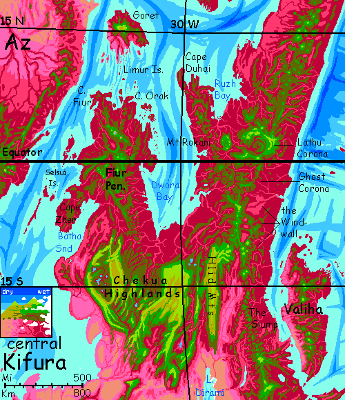
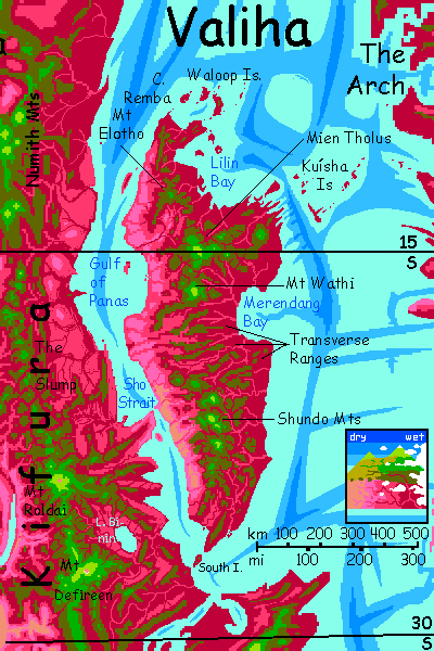
On Capsican maps, Valiha looks amazingly like Madagascar. Part of that's just size and location--Valiha's a big island east of the rather African continent of Kifura. The similar size and shape hide geological differences: Madagascar's a formidable chunk of land jutting high above the Indian seabasin, but drop Valiha into the Indian Ocean and it'd almost disappear: only the highest of its volcanoes would poke their summits above water as mere islets. Only because Capsica's seas are so shallow does the Valiha tectonic platelet form an island at all.
Despite its shape, Valiha isn't Madagascar's geographical clone either. Or if it is, some fool installed it backwards: the mountains here hug the west coast, leaving a long slope to the east, the opposite of Madagascar.
That has consequences: at this latitude, most rains sweep in from the southeast. Madagascar has a narrow jungle along its wet east coast and a broad drier western slope. On more arid Capsica, Valiha's broad side faces the rains. Biomass is much higher than Madagascar, or mainland Kifura for that matter, due only to orientation!
Geography matters.
Introduction - Touring - North to South - The Mountaintops
Roughing in a tour for Earth tourists was easy this time--there's only one route that has any hope of not cooking you all. We'll enter from the Numith Mountains of eastern Kifura, head south down the island's spine, and fly back to Kifura.
Capsicans have the option of flying east to the equatorial Arch, and on to the gigantic Martian volcanoes of the Ekurre Peninsula, but you don't. It's both too hot and too long--a full day or two over water, and no cool heights to rest on for a day after that, in the mountains of the central Arch--well inland. Not gonna happen.
Introduction - Touring - North to South - The Mountaintops
You come in tired and sweaty--hours in the air. The indigo sea gradually shallows, turning turquoise, feathered with purple and brown pseudokelp forests.
Land. A sweep of rippling lavender slopes: hotgrass nodding in wind. Herds of... what? Deer-size, as far as you can tell. Something startles a group of a hundred or two; they leap and take wing, diving and dodging like a shimmery school of deer-fish. Or is that too poetic? Pigeon-cows, then.
Ahead, the pale savanna rises to ruddier highlands. Head for those. They darken to plum mixed with olive then spangles of green as you climb. Blue skies around you, here on the narrow dry side; but clouds crown the summits.
Go for the highest, Mt Elotho; the extra work now will be worth it in a cooler campsite. But it is work; no easy updrafts here. You're on the lee side of the mountains, and tradewinds sweep downslope. Updrafts rise from the scorching coastal flats, but it's 55°C down there (131°F); you need the peaks. Find a high meadow near the summit of Mt Elotho and land.
Seek shade. Rest, try to sleep, but I wouldn't recommend camping here long. You won't truly recover from your strait-crossing here. It's 40°C (104°F) at night, and that's as cool as it ever gets. We're just not high enough--just 2800 m (9,200'). Push on. Try to ride the east faces of the mountains; they're windward.
By afternoon you've reached the North-Central Group, the highest and coolest peaks on Valiha. Rest up here! The best you'll get. One night it actually drops to 30°C (86°F). Ahhhh.
As I said, this isn't a Madagascar clone; it got installed backwards. So the broad plains and slopes to your left are red white and plum-purple: flocks of cumulus wander over dense tropical forest, crimson in sun, cloudshadowed to plum. Even from the summit-crater of Mien Tholus, at 4500 m (14,750'), the jungle extends to the horizon, lost in cloud. But to your right is pink to lavender savanna clotted and ribboned with rose-colored groves and broken by brown and gold rock outcrops--vaguely African. But this slightly off-color Africa is really quite narrow; that dim turquoise strip on the horizon is the sea you crossed.
Here's where native Capsicans often peel off east on the Ekurre Flyway: northeast along a mountain spur--high and cool enough so even you could get near the coast. But then the flyway hops along the low, equatorial Kuisha Islands--far too hot and humid for you. If you could survive two days of that, and another of low coastal hills on The Arch, you could reach the almost bearable heights around the rim of the Arch's central rift. Cross that (against the wind, as this whole detour has been--good luck!) and a few more days of steamy ridge-running, and you'd reach the gigantic Martian volcanoes of the Ekurre Peninsula, with heights so cool they could be Earth. But you wouldn't make it. The sea-passage is just too hot for too long. Your only survivable way lies south.
Another day southwest to the Mt Wathi complex, nearly as high as Mien Tholus. An overlapping confusion of volcanoes; fortunately none currently active. Wathi's name is a local word for "White"; not because the mountain's ever snowcapped, even in the coldest winter, of cours; it's for the lenticular clouds often seen above the summit as that humid air is suddenly forced three miles high.
Ahead to the south lie olive cloudforest-clad ridges, little over half your current height. White banners straggle west through gaps. These lower transverse ridges of the Central Narrows, between Merendang Bay and the Gulf of Panas, are an uncomfortable stretch for you. ('Uncomfortable' is my euphemism for 40° heat, occasionally spiking to 45 (104-113°F); and rather high humidity). Start early and rest early before the full heat of the day; get well above the peaks in afternoon, hiding in cloud-shade where you can.
That silver to your left is broad Merendang Bay. Here at the island's narrow waist, storms off Merendang sweep right through the gaps you must traverse, so the land's red and cloud-dappled shore to shore. Had the same ridges been oriented north-south, your travels would be higher, cooler, and drier--easier all round--but the west would be a desert. Orientation again...
Things improve for you by evening; you reach the long cool wedge of the Shundo Mountains. True green again, days no higher than 35-40°C (95-104°F)--though humid--with nights down as low as 30-35°C (86-95°F). Sit in a creek. Relief! Rest up and enjoy it. But beware what's below you to the west now. The southern highlands you're perching on are more continuous than the cones and ridges you've been hopping between. They cast a substantial rainshadow on the west coast; it's pale pink to tans, golds, chocolate browns. Almost looks Terran down there. But that's just because it's near-desert, the first you've seen! Too dry for the rhodophores that make most Capsican lowlands look so alien. This seems Terran, but the heat down there's fatal.
So be absolutely sure of your wings and your water supply as you prepare for the long flight back over Sho Strait to Kifura. Stay high, ride those thermals driven by the fierce heat below. For you, narrow Sho Strait is irrelevant--the real strait is of heat not water, and much wider. Head for the hot, humid eastern spurs of Mt Roldai in the Numith Range, south of the Slump. Camp anywhere green (above 3 km, 10,000'). It won't matter which spur you follow--all roads lead to Roldai. It's a real giant, 7 km high (23,000'). You can't miss it and you won't want to; its high cool shoulders are a gentle, Polynesian refuge to you, after weeks of sweltering heat on Valiha.
There is a second, more thorough tour you can take--keep on down the Shundo Range. While its southern peaks are lower, you're also heading out of the tropics; it doesn't take quite the same height to cool off the cloud forests here to something tolerable. The sky-islands grow smaller, but not unbearably hot. The range forks; take the eastern spur. Soon you're seeing the sea, far to your left, beyond the rumpled maroon carpet of hills. To your right, pink savanna between the two ranges. The sea nears, the other spur lowers... Valiha is narrowing. Near sundown, you can see both east and west coast at once.
Next day you reach the end: South Strait. It's really two--Valiha Channel, 16 km wide (10 mi) between Valiha and the imaginatively named South Island, and Mainland Channel, just 13 km wide (8 mi), between South Island and Kifura. Peaks here are under 3 km, but even on the island, two reach into the olive zone--you'll sleep hot, but you CAN rest and sleep before tackling the second channel. On the mainland, just head southwest a day or two, toward Mount Defireen, a cool volcanic giant 250 km south of Mt Roldai, and even taller--9.3 km high (30,500'). It even gets snow in winter!
On the cool comfortable shoulders of Defireen, you'll meet some friends--those travelers who took the Sho Strait route--and those (more sensible) folk who skipped Valiha entirely. Tropical detours are never relaxing. Not on Capsica.
Introduction - Touring - North to South - The Mountaintops
Quite Earthlike tropical groves and meadows. Rain-bearing cloudlayers in the Capsican tropics climb well above Earth's; high-altitude equatorial deserts are rare, appearing only above 6-7 km. Why? Four factors all conspire to give Capsican highlands more rain:

World Dream Bank homepage - Art gallery - New stuff - Introductory sampler, best dreams, best art - On dreamwork - Books
Indexes: Subject - Author - Date - Names - Places - Art media/styles
Titles: A - B - C - D - E - F - G - H - IJ - KL - M - NO - PQ - R - Sa-Sk - Sl-Sz - T - UV - WXYZ
Email: wdreamb@yahoo.com - Catalog of art, books, CDs - Behind the Curtain: FAQs, bio, site map - Kindred sites