Welcome to Jaredia
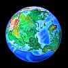
An experimental world:
one of a series of alternate worlds created by tilting Earth's axis,
exploring climatology, evolution, and cultural geography
by Chris Wayan, 2003
Welcome to Jaredia
An experimental world:
one of a series of alternate worlds created by tilting Earth's axis,
exploring climatology, evolution, and cultural geography
by Chris Wayan, 2003
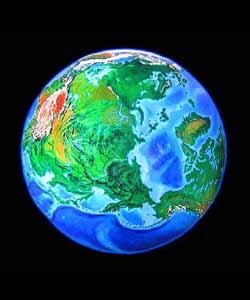
Jared Diamond's book "Guns, Germs and Steel" is much on my mind these days. Its thesis is that civilization developed in Eurasia fastest for ecological not cultural or racial reasons. Eurasia's size and eco-diversity gave it more species of domesticable plants and animals than other continents, certain favorable climates and landforms (a Mediterranean dry season eases grain-storage, for example), a long human presence (late discovery of the New World meant mass extinction of large mammals that might have been domesticable), and east-west trade routes (pigs and wheat do well in both France and China, but Mexican corn took centuries to adapt to Ohio). His theory's complex, and rather than discuss it, I prefer to sculpt it--I'm an artist, after all!
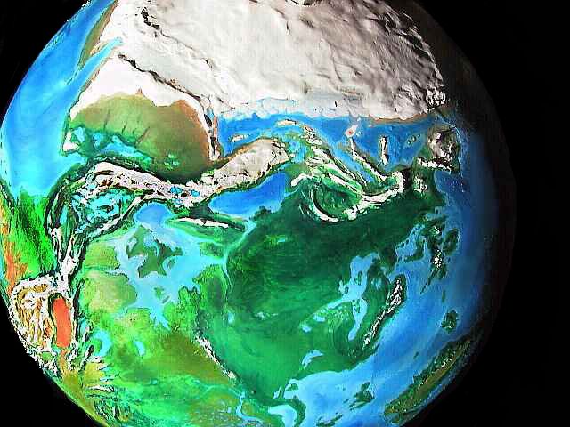
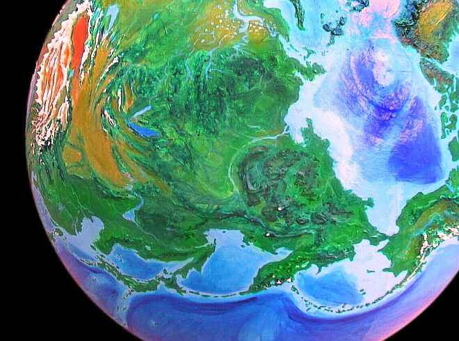
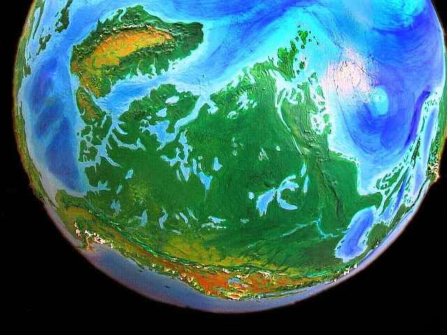
So here's a tilted Earth that should foster a quick, relatively even growth of civilization--if he's right. I've created the widest possible east-west zone by turning the Americas sideways. Africa froze, but in exchange, Australia and Antarctica turned green and the Americas linked to Asia over the now-exposed Bering landbridge. Half the world's in a single Jaredian climate-belt--tropical, as it happens.
Why Africa? Well, if I'm sticking to Earth's geography, only allowing myself to tilt the planet, the Pacific Rim is the most sustained possible east-west strip. And to level it, I had to put my poles in the central Pacific and Africa. At first I was upset over the sheer size of the resulting icecap--they generally spoil the climate for thousands of miles around--but to follow Jared's hypothesis, I needed a land-bridge over the Bering Strait anyway, and that requires a good-sized polar cap to lower the sea levels. So I went with it despite Africa. You win some, you lose some...
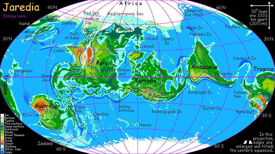
It's not quite all distortion. My African icecap is big--over 50% more ice than Antarctica. That locks up so much water that sea levels have dropped 40 meters. The Bering Straits are gone--there's a permanent land-bridge. And it's tropical--friendly land. In fact, you can walk from Bali to Cape Horn, two-thirds of the way around the world, and never leave the tropics!
The whole southern hemisphere is relatively warm, for the south pole has only sea-ice, and is sealed in a ring of currents and winds unblocked by land-except the poor ice-bound islands of Polynesia.
The equatorial current travels west around the Pacific Rim, heating up for 30,000 km before much of it squeezes through the straits between Bali and Australia, to warm and strengthen the currents circling in the Indian and East Atlantic Oceans. This hot-water pump helps keep the northern ice in check. So even the African Cap isn't as cold as Antarctica; I modeled it on the temperate caps during the last Ice Age. Tundra grows nearly to the foot of the ice, and low forests begin not so far away. Why? For orbital reasons I won't detail here, the northern hemisphere has inherently milder winters than the south. Also, our Antarctica's isolated--no warm currents hit it, while this African icecap has four separate warm currents fencing it in.
Is the situation stable? I doubt it--ours isn't.
I've shown the icecap in a mild interglacial phase; in cold eras, the Mediterranean freezes over, and half Italy and all of Spain would go--maybe even central Europe. And the mountain glaciers of Turkey, Iran and the Red Sea spread till they meet, swallowing everything to the shores of the Caspian. Though even in such cold eras, I suspect the hot currents of the Indian Ocean will keep its coasts generally ice-free, ceding only Arabia to the advancing ice.
This current interglacial's sea level is 40 meters below ours--130' down. Sounds like a big drop, but it's trivial really; our sea level has varied a good 250 meters in our last million years alone! Jaredia's lower seas bare several million square kilometers of islands, reefs and coasts. Japan, Britain, and Java-Sumatra are now capes; they'll be settled by early (even pre-) humans. But the change that matters, if Jared is right, is that the land-bridge to America is permanent and tropical--and that means easy! The Old World here consists of Eurasia and the Americas; it will develop as one. Australia will still require boats to reach, but the straits are much smaller now. I'd expect it to be settled quite a bit earlier, though long after the Americas.
Is there a New World, an untouched land that only true deepwater sailors can discover? Yes, and it's a land none of us have ever seen. Jaredia's equivalent of Polynesians have a spectacular find waiting for them--Antarctica free of its ice.
So join me on...
intro - map - Africa - Eurabia - India - Tibet - Java - Oceania - Siberia - Tortolia - Greenland - Amazonia - Tropica - biology - culture - Randomia - lessons - roots
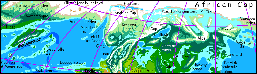
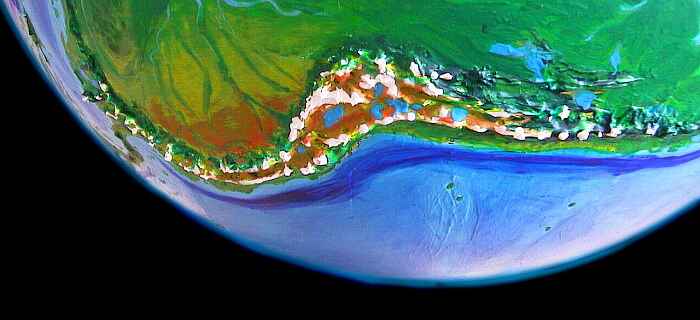
Let's start with the worst news. A huge ice-cap covers most of Africa, miles deep. Well, not completely covered: southern Africa's a tundra oasis--a land we'd recognize immediately as much like our world's Ice Age Europe. Its size varies--in cold eras, ice swallows much of it. Still, even at maximal glaciation, the Drakensberg Mountains and strong warm currents offshore keep the ice from reaching Natal, the far southern coast. In this wooded refuge, an extensive flora and fauna always survives to recolonize the cool, windy plains to the north in warmer times.
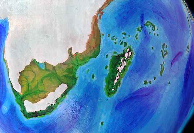
To the southeast, in Mozambique, the lower, windy coast suffers harsh, stormy winters but fairly warm summers; evergreens survive up along the coast up to Tanzania, northeast of which is just tundra and bare ground, like Greenland. Ice covers Kilimanjaro and the other great peaks, and the plateaus behind, but the shore is washed in the Madagascar Current and stays ice-free (though cold and pretty barren) all the way up through Somalia.
Life survives on other fringes of Africa. The tall Atlas Mountains of Morocco hold the ice back. While the Moroccan coast is mostly cold windy tundra, it too is more Greenlandic than Antarctic: in valleys along the shore the warm Azorean Current allows grasses and even a few stunted trees.
All along the Atlantic coast, though the icecap looms over the sea, floating ice isn't extensive, even in winter; the offshore currents are just too warm. The seas here explode with life; the cold windy Canaries and Cape Blancas and even the ice-locked Cameroon Isles are havens for seal and walrus, penguin and polar bear.
intro - map - Africa - Eurabia - India - Tibet - Java - Oceania - Siberia - Tortolia - Greenland - Amazonia - Tropica - biology - culture - Randomia - lessons - roots
The Mediterranean's a chill gray sea at the best of times. The lowlands of Spain, Italy, Greece and Lebanon are lichen and tundra and bog, when they thaw at all. Turkey and central Spain, being plateaus, have iced over like little Greenlands. Indeed all the mountains are ice-crowned--except Etna, eerily bare, a lone fire above the ice.
South of the Alps and Pyrenees, life takes firm hold. Scattered spruce and fir woods deepen into dark Canadian forests. Well, not Canadian: tigers roam, hunting giant elk, though the mammoths are gone, hunted out eons ago.
Britain's a somber wooded cape linked to chilly, Nordic France. Britain's warmer than the mainland, though, and far larger than in our world--much of the North Sea is forest and bog. The Isle of Man is now the Cape of Man; the Giant's Causeway may link even Ireland to the mainland.
Scandinavia, especially Lapland, is mild, rather French, though its peaks inland are snowy year-round. The Baltic Sea is now a great freshwater lake draining through the Skagerrak River to the shrunken North Sea. Perhaps the analogy I should be making is not European at all, but American: the British Peninsula as New England, Scandinavia as, say, Pennsylvania-to-Virginia, with huge Lake Baltica inland. And beyond it the great forest thins slowly to the west. But not into the American prairie. Not exactly...
The snowline is the real divider on Jaredia, not our continental names. For that reason, rather than proceeding south, we'll head west, over the Elburz Mountains into Iran, a strange Alaskan plateau, with huge cold lakes and stunted spruce forests, ringed by glacial mountains. The land is a maze--a third water, a third ice, a third forest.
Northwest, over the Zagros mountains, is the marshy plain of Jazeera, dotted with great lakes where our world's Persian Gulf lies. Beyond the woods and lakes lies only tundra, rising slowly to the glacial ranges bordering the Red Sea. Yemen's under a mile of ice, though the shore is bare, and Oman to the south resembles Iran, with great lakes and piny woods; a bit warmer, for though it's north of Iran, the land is much lower, except for the coast range, an icefield nearly 3 km above the marshy plains.
intro - map - Africa - Eurabia - India - Tibet - Java - Oceania - Siberia - Tortolia - Greenland - Amazonia - Tropica - biology - culture - Randomia - lessons - roots
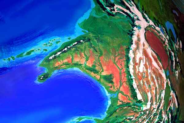
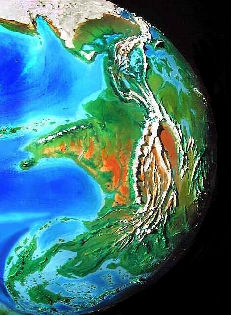
The desert exists on Jaredia too: it's the plain around the Ganges and Brahmaputra. Only the many snowfed rivers create sinuous green oases. This isn't the lonely Nile--there are dozens of tributary river-valleys! Rich with glacial silt, they'll begin as meadow and marsh and strip woodlands, but they're ideal for irrigated farming. The Ganges Desert will be a cradle of Jaredian civilization comparable to our Fertile Crescent.
Much of the Deccan is scrub desert, though the higher Ghats squeeze enough rain to support Mediterranean olive groves and open woods.
Cape Lanka (Ceylon is linked to the mainland, of course) and the coast northeast to Bombay is temperate and green--quite Mediterranean or Californian. This pleasant shore will have mild weather with summer fogs due to the cool Somali Current, rich in fish--a marine treasure chest luring fishers further and further offshore... and into the arts of deep-sea navigation.
These maritime Bombalankans will quickly discover a great chain of islands and reefs (the Laccadives and Maldives, but much larger than on Earth) leading west 2500 km toward the Seychelle Arc and Madagascar. Just as the Vikings hopped from Scandinavia to the Faeroes to Iceland to Greenland to America, the Bombalankan Indians will eventually stumble on a sea-route to these rich lands. And the Bombalankans (plus the Pakistanis and Jazeerans they trade with) are the only people in this hemisphere (aside from the distant Britons, perhaps) who might have crops and animals adapted for Madagascar's cool-temperate climate.
Beyond Madagascar, they'll find the island-chains leading to the African shore unpromisingly cold and windy. And the tundras beyond the coastal woods, crawling with Ice Age monsters will seem even more dismal to these farmers and fishers. The well-armed savages hunting the monsters won't help. It's a rich land for hunters who don't mind a little danger. Well, a lot of danger.
But eventually some storm-tossed ship will blunder west all the way to the much milder Natal Coast, a land ideal for Madagascarene invaders, who'd likely dispossess the local hunter-gatherers.
Whether Madagascarenes would eventually sail on across the East Atlantic, to try and wrest the northern tip of Brazil from its inhabitants, is a question we'll leave for specialists in alternative history of the more militaristic sort. We deal in ecology.
intro - map - Africa - Eurabia - India - Tibet - Java - Oceania - Siberia - Tortolia - Greenland - Amazonia - Tropica - biology - culture - Randomia - lessons - roots
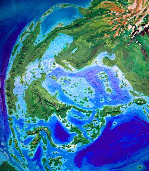
Tibet? Tibet is still Tibet. Sometimes altitude is destiny. Wait, I'm exaggerating--there are changes. Lhasa's river valley in the southwest, and the Tsaidam plateau in the far southeast (both a mere 3 to 3.5 km meters high instead of 4-5) are closer to the equator on Jaredia, warming them enough to become cool but fertile highlands. In summer, they get significant rain, too, sweeping up from the south. Not a full-on monsoon, but enough to cover the slopes in grass and nourish trees along streams.
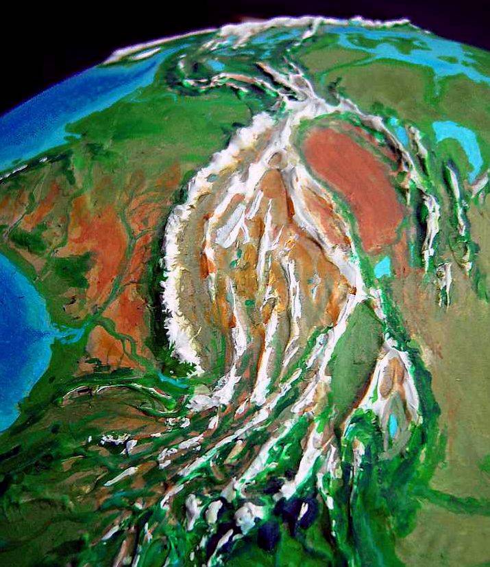
Even warmer are the inaccessible but spectacular gorges of southern Tibet, where all the great rivers of South Asia flow parallel, only a few miles apart--but those few miles are mountain ridges rising 4-5000 meters. Bananas in Tibet? Oranges, at least.
Looming above these gorges, at 7500 meters (24,500') is the isolated peak of Minya Gonga, which, for a thousand kilometers around, will be the home of the gods.
Central Asia is still relatively dry, but the only true desert is the Takla Makan, trapped between Tibet and the Tien Shan--this basin is dry in every single alternate world I've devised, for with the world's highest peaks around it, rain just can't get in. Aside from streams around the rim, draining to the swampy Lop Nor in the south, this is land under a geographic curse. A new (ahem) attitude can't fix it.
But the many ranges to the east, from the Tien Shan to the Altai, are warmer and rainier than in our world, with sheltered valleys where pastures and wild apples flourish. The wider valleys and plains, from Dzungaria in the north to the Gobi in the south, add up to the biggest grasslands in the world. The Gobi Desert is gone and winters here are milder; most of the year, predominant winds come from the south, bringing both warmth and rain.
This region of Asia is best compared to our East Africa during the Ice Age: scattered wooded ranges with warm savanna plains between. Apes from the jungles of China who explore these grasslands may take the first steps toward becoming human...
For the moment, let's turn southwest, leaving China and Siberia for later.
intro - map - Africa - Eurabia - India - Tibet - Great Java - Oceania - Siberia - Tortolia - Greenland - Amazonia - Tropica - biology - culture - Randomia - lessons
Now we enter another continent, south of the snows, where ice is a mirage--mountains floating on the horizon.
The Jaredian incarnation of Indochina is generally drier than Earth's. Burma's floodplain has a monsoon in good years, but in bad ones there's only the great river, descending from the Tibetan snows, like the Ganges and Brahmaputra.
The upper Mekong and Irrawaddy rivers have cut spectacular canyons into the Himalaya's southern spurs, just as on Earth, but here, they're dissected redrock canyons full of cliffs and towers; hot canyons and high cold ridges generate thunderstorms and heavy erosion.
Burma's not as lush as in our world--a strong monsoon, but a long dry season; more like our India in a so-so year. Thailand is greener, almost like ours.
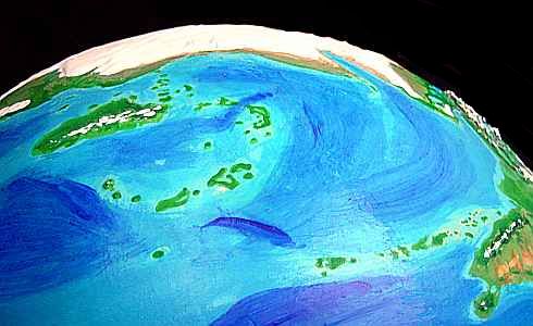
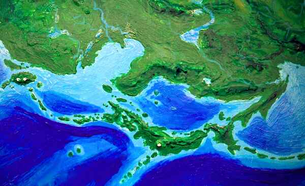
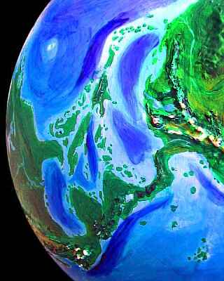
Wetter still: the equatorial peninsulas of Vietnam (enlarged and with a strange hook at the southern tip) and Great Java (Malaya-Sumatra-Java-Bali) form one huge continuous rainforest, with satellites offshore: Borneo, the Philippines, the Moluccas and Sundas.
There's some uncertainty about Borneo: it's certainly fused with Palawan, the long Philippine isle to its east, but depending on water levels, it might even link to Great Java, forming a single jagged subcontinent of several million square kilometers.
Except for Mindanao, most of the other Philippine islands have fused with Luzon, and an island chain nearly links Luzon to Taiwan.
The strait between Taiwan and the mainland has been nearly filled by Pescador, a low green island half the size of Taiwan itself. This China-Pescador-Taiwan-Luzon-Mindanao-Sulawesi-Papua route is a potential highway to Australia, one which might have been traversed in quite primitive boats--meaning, in very early times--even assuming no Jaredian ice ages when sea levels drop still further.
Jared Diamond quotes linguistic evidence that just such a migration happened in our world, with higher water levels and smaller isles, though only 3500 years ago: native Taiwanese spread southeast into the Pacific, to become the Polynesians! Here, it would be easier and happen far earlier.
intro - map - Africa - Eurabia - India - Tibet - Java - Oceania - Siberia - Tortolia - Greenland - Amazonia - Tropica - biology - culture - Randomia - lessons - roots
The Jaredian rainforest doesn't end in Indonesia. Papua (New Guinea) is now the east coast of Australia--the low sea has bared a land-bridge between them. Lush forest covers Papua's lowlands, but in the south they're temperate not tropical. The mountains are snowcapped and spectacular in places, rising 4-5000 meters. Highland valleys are grassy and alpine--herding not farming country. Jaredian populations will crowd the lowlands, not the highlands as in our world.
 The hardwood forests of Papua stretch across the York Isthmus to cover a million square km of Australia proper, too. The southern coast is cooler yet, occasionally seeing snow even at sea level--pine and redwood dominate the dark, dense woods here.
Offshore, Tasmania's nearly anchored to the mainland by island chains; it will never become culturally isolated as it did in our world. North, over the snowy coast range, lies the Darling Prairie, a million square kilometers of grassland, watered by snowmelt. Beyond the central Flinders Range is Adelaide at the mouth of the wide Eyre River. To the east, the Great Lakes: Eyre, Torrens and half a dozen others make a sapphire necklace from the west coast two-thirds of the way across the continent. North of the lakes is the last gasp of the Australian desert: just a Sahelian patch along the appropriately named Nullarbor Plain, in the rainshadow of the central Macdonnell Ranges, with their forested ridges and rust-red canyons. North of this, along the Indian Ocean from Perth to Darwin, is a wide savanna, deepening to jungle--and this is no timid coastal strip, for the northeast coast has widened by some two hundred miles--it stretches halfway to Timor.
New islands and reefs make crossings from Timor even easier; Australia will be settled early.
New isles have surfaced in the gaps between Great Java/Borneo and Papua, too. The Timor routes, the Borneo route and the Taiwan-Luzon route mentioned above are now short, relatively easy island-hops, making it likely Jaredians would settle Australia long before we managed it (around 40,000 BP). A wave of mass extinctions probably still resulted, but the invaders might be so early and primitive that (as in our Africa and Eurasia, and unlike Australia and Americas) many large animals would have time to adapt, learn to fear humans, and survive (to be domesticated later on?). Whether or not that happens, Australia is likely richer in megafauna as well as biomass--full of giant lizards, marsupials, and flightless birds. And people--even before agriculture, it's so much larger and richer, it could support millions.
An afterthought about that temperate south coast. The people here will have to develop crops of their own; the tropical staples of the Jaredian Belt won't grow here. The region may be backward, but if its people do establish a suite of temperate crops, they, and not the main-belt Jaredians, will spread over the Pacific archipelagoes, which are cool and rainy, with some winter snow--temperate, despite high latitudes, for there's no Greenland or Antarctica here in the south: the only polar cap is sea-ice a few meters thick in winter, shrinking and breaking up in summer. The prevailing winds beyond the Antarctic Convergence around sixty south spin this great floating cap, or try; every Polynesian island becomes an icebreaker, tearing up the sheet in late spring. Of course it works both ways; only active volcanoes can stand long against the shearing. Spinning like a geological sawblade, the Southern Ice leaves only guyots--flat-topped seamounts and reefs that can't even develop coldwater reefs on their sunlit tops; life cowers on the dim slopes.
New Zealand can scoff at the buzz saw. With the lower sea level, it's much larger, though a narrow strait still separates the two islands. But it reaches 66 degrees south! Without an Antarctic ice cap, the climate's milder than Earth at this latitude; New Zealand's quite Nordic, with fjords and somber forests thinning to tundra in the far south (our North Island). Yet the north, below Mt Cook, is fertile and cool-temperate; south-Australian settlers would find it a second homeland.
This great chain--fifty or more islands, not our eight--is cool and rainy, but rarely snowy in winter on the coasts, though great glaciers cover the volcanoes--when they're not busy building more land. Ice and fire! The latitude is close to 60 south--not far from our Antarctic Peninsula, or Kamchatka--but without a true polar cap, winters are no worse than England's. Our South Australians will flourish.
The big question is: will this by-now thoroughly maritime people merely trade with the tropics, causing a local Renaissance, or venture "round the Horn"--not as risky a venture as in our world, since the Horn is now equatorial, but just as long a trip (it's exactly the same Horn after all. I haven't altered geography a bit, remember, whatever the world map looks like!)
Say our Zealanders and South Australians thus contact the Europeans. Or vice versa, I guess--the mariners of the British Peninsula might develop deepwater skills, but they simply won't have had as much motivation; nothing like the huge, scattered archipelago in the south seas. So my bet's on the southerners to "discover" the north. But whoever makes first contact, once these two temperate zones exchange snow-tolerant crops and animals, I suspect twin Renaissances will bloom in the muddy streets of Honolulu and Sydney, Belfast and Dubai--places tropical Jaredians (like our Romans) see as inherently barbaric, cursed by bad weather to be forever savage--like Shakespearean London.
Of course, our Temperates might also found an empire on sea-trade as the British did. Or just loot their neighbors like the Vikings, spreading misery and slowing civilization's rise another few centuries, until the tropical Jaredians match their seafaring skill, or fail to and go under...
On that pleasant thought, let's head back to warmer territory: Siberia.
intro - map - Africa - Eurabia - India - Tibet - Java - Oceania - Siberia - Tortolia - Greenland - Amazonia - Tropica - biology - culture - Randomia - lessons - roots
Other tilted Earths I've built have had fertile Siberias, but this one's unusual in that the low sealevel creates one unified land from the Urals to the Bering Strait and inland to Lake Baikal, centered on the great Lena River Valley. My guess it that this land would develop as one huge nation, either colonizing the Asian peninsulas like Kamchatka, Korea and Japan, or merely exporting its culture and inventions to the "barbarians". But this Siberia couldn't isolate itself easily, as China did; it's at the world's crossroads. If it turns inward and stagnates, the Alaskans, Kamchatkans, Japanese, Mongolians, or Chinese, living on trade from Australia, India and America, will inevitably move ahead, forcing the Siberian monolith to modernize or die.
Further east, the twisting, verdant Okhotsk shore is sheltered by Japan's eastern twin: Kamchatka. Here, wide, rainy, flat lowlands stretch below a whole chain of Fuji-size volcanoes. One's a full kilometer higher--Klyucha, perpetually snowcapped even at the equator: the sacred peak of the region. Pilgrims will come from Japan and Siberia to climb it--and to see the world. For Kamchatka's cosmopolitan. All the world's land trade must pass over the Bering Isthmus--the gateway to the Americas.
intro - map - Africa - Eurabia - India - Tibet - Java - Oceania - Siberia - Tortolia - Greenland - Amazonia - Tropica - biology - culture - Randomia - lessons - roots
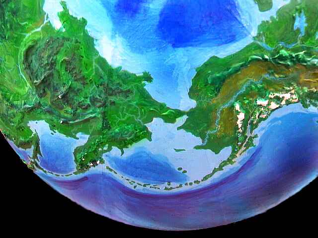
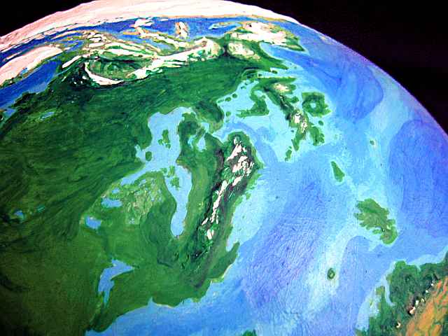
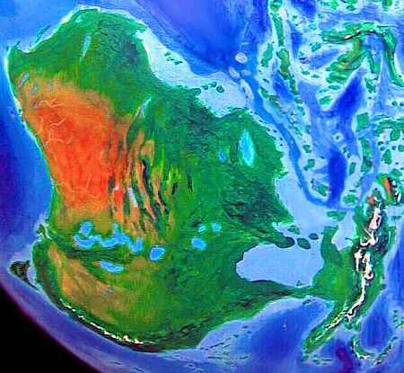
North America is now south of South America. To avoid confusion, let's call it Tortolia, after the native name, Turtle Island.
I have no doubt Alaska would be a major cradle of civilizations--it's fertile, ecologically diverse, and a crossroads for both land and sea trade. The gods would, of course, live atop Denali. The land is rainforest on the coasts, but savanna inland in the Yukon basin, between the Brooks and Alaska ranges. The savanna corridor leads all the way to Mexico, though much broken up by wooded mountains, canyons, and local deserts. East of Seattle and the Puget Lakes, the Pacific coast turns dry, at least at low altitudes. But the many uplands (Coast Range, Cascades, Sierra Nevada, Transverse Range, Baja, Sierra Madre) are mild to cool, and catch enough rain to be fertile. Inland, beyond the mountains, the Utah Sea never dried up, nor did Lake Lahontan in Nevada or a dozen others, dotting a patchwork of prairie, forest, mountain and canyon much like East Africa at the dawn of man; and it's likely apes would roam the huge Mississippi rainforest to the north. Would they break out onto the savanna and desert here? This could be humanity's cradle. It's a toss-up between Utah and Mongolia... and, as we'll see, Greenland. Yes, Greenland.
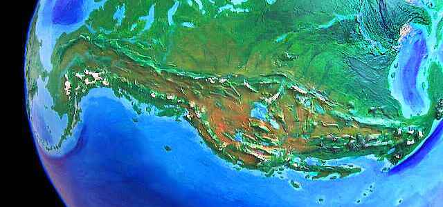
And paralleling it is another east-west corridor. The high plains of Alberta range from savanna to open grassland below the western Rockies. But in general, north of the Rockies, the High Plains are forested; indeed the Mississippi basin is an Amazonian rainforest, while Appalachia and most of Canada are pleasant subtropical woods suitable for farming, like Siberia to the west. The shores are shallow; great coral reefs flourish. This maze of islands, reefs, and gulfs stretches from Florida to the isles of Baffin Bay, and around to the Mackenzie Valley near Alaska. Native cultures will be coastal and riverine! Unbroken continental rainforests aren't centers of innovation in our world; they're actually quite hard to live in (getting protein's a problem) and sustain low populations. Broken, coastal and island rainforests, on the other hand, can sustain high populations and cultures, often maritime: Java, the Maya, Polynesia, Hispaniola (it supported millions before Columbus brought them slavery and smallpox.) Tortolia's coasts are of this second, promising type, and I'd expect to see rich maritime cultures, especially on its cooler, drier north and west shores, where each of the large islands could develop its own culture. And such maritime cultures could spread inland--not only to the Great Lakes and the Canadian Lakes (Bear, Slave, Athabasca, Reindeer, and Winnipeg) but to a third, equally large complex where our Hudson Bay lies.
Paradoxically, we're on firmer ground offshore...
intro - map - Africa - Eurabia - India - Tibet - Java - Oceania - Siberia - Tortolia - Greenland - Amazonia - Tropica - biology - culture - Randomia - lessons - roots
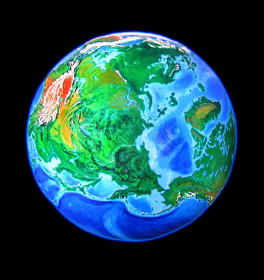
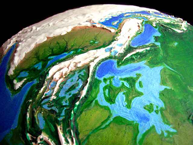
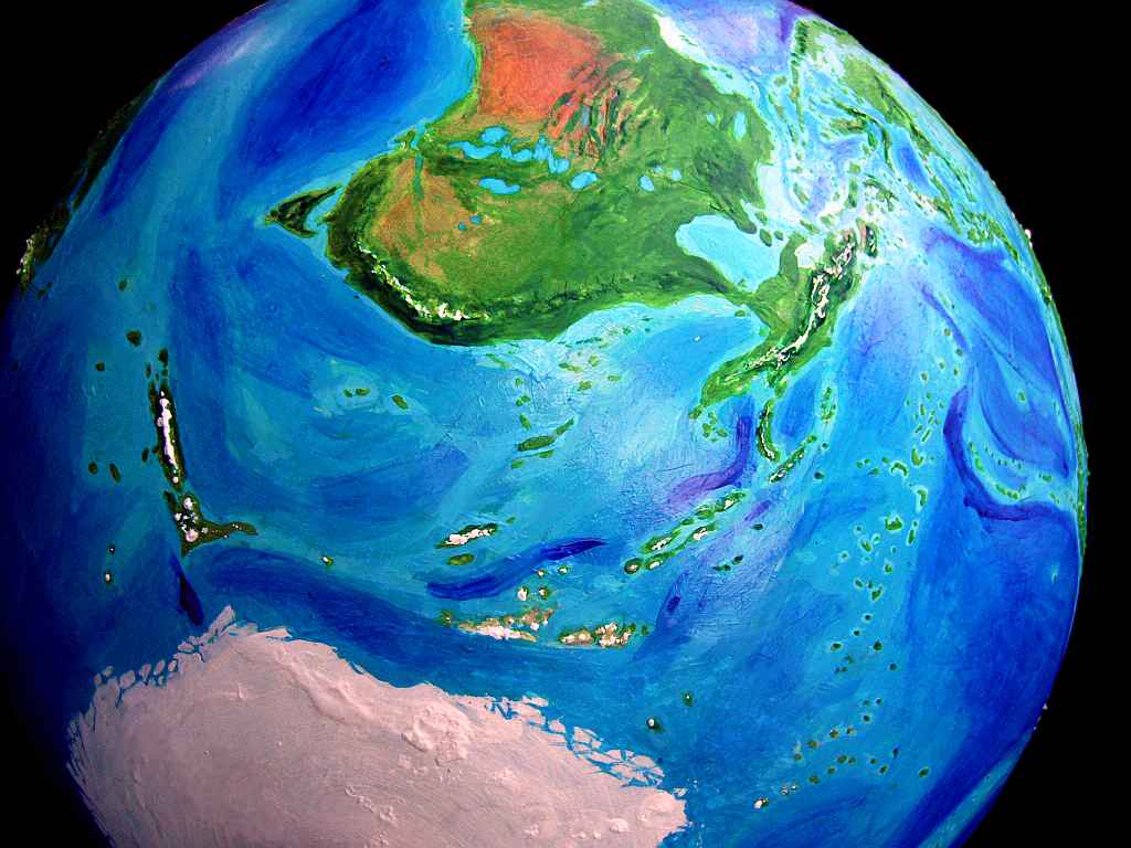
I must note that our Greenland's drainage is different--recent soundings show our Rasmussen Basin drained during some interglacial period (perhaps catastrophically) via a channel through the hills at far left in the orbital photo, not the bottom center as shown--in our world, that coast was likely ice-dammed. What you see here is a Greenland that never iced up--no need to avoid an ice-dam by carving a canyon through the hills. This Rasmussen has it easy, meandering peacefully out to Baffin Bay.
The Greenland veldt supports huge migratory herds preyed on by quasi-lions, cheetahs, and sabertooths. Marsupials?
Greenland gets even less green in the west; the Kennedy Channel and huge Ellesmere Island have red desert coasts, practically Sonoran. Still, Ellesmere's mountains, rising to 2500 meters, catch the rain and support pine forests, and scattered oaks lower down. The cultures of Tortolia, with crops adapted for wet tropics, wouldn't do well here or on the veldt. But during ice ages, the Kennedy Strait might become a land bridge--(depending on how much higher the region would be without Greenland's ice), and if so, apes might spread to Greenland from the Canadian jungles. If so, the vast Greenlandic Veldt would beckon for those willing to risk coming out of the trees...
Crazy though it sounds, Greenland could be where protohumans evolve. We may cross the Bering Bridge, all right--but in the other direction!
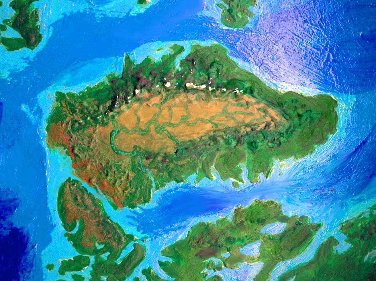
Much of the Caribbean and Gulf coast is low-lying. So Jaredia's Caribbean has both more and larger islands; for example, Andros Island in the Bahamas is nearly the size of Florida, itself doubled in size, fattened as if on steroids; Cuba and Yucatan have reached out hands and nearly touched; Jamaica has a low-lying twin...
I won't go into detail because ecologically all these isles and capes are much like the Tortolian coastal rainforest, and probably have similar cultures.
If our own Caribbean is any guide, this means high populations; if Jared's right about sheer numbers promoting innovation and east-west corridors spreading it, the region will develop civilizations like the Olmec, Maya and Mound Builders much earlier, and advance much faster. For maize, potatoes, quinoa, beans, avocadoes, sunflower and squash seeds will spread from Mexico and Peru to become worldwide staples, from time out of mind. Even peasants too poor for meat (assuming Jaredians are even a species that eats it, of course) will have diets high in protein, B vitamins, healthy oils.
And chocolate. Now that's important! Consider: the stimulatin' bean spreads round the Jaredian Strip, and immediately people feel all loved and creative and talkative. The Renaissance flowers and modern science begins. Jaredian art and science will rise early and far, rocketfueled by cacao. Bittersweet. With cinnamon, and... I have to take a break now. To renew my inspiration and do some, uh, research.
intro - map - Africa - Eurabia - India - Tibet - Java - Oceania - Siberia - Tortolia - Greenland - Amazonia - Tropica - biology - culture - Randomia - lessons - roots
As South America's now northeast of North America, let's call it Amazonia--though it's no longer really dominated by the Amazon. Orientation matters as much as latitude; and while South America still straddles the equator, it's rotated almost 90 degrees; storm-paths are utterly different.
From Panama to Cape Horn, Amazonia's south coast is evenly lush, and will inevitably become a great migration- and trade-route, passing crops and ideas along its endless fertile shore. If anyone acts out the dream that led me to Jaredia, of walking from Bali to Tierra Del Fuego, two-thirds of the way around the world, they'll take this route.
The Andean highlands are now much warmer at their Chilean end, more like our tropical Andes, as in Colombia, for instead of slashing across the equator, the long plateau parallels it. Equatorial rains mostly fall in the foothils, but enough now reaches the highlands so Lake Titicaca has grown, and has four huge sisters: Poop�, Coipasa, Uyuni (larger than Titicaca) and Atacama--together, some 50,000 square kilometers of water. These moderate the climate of the altiplano--cool dry grasslands, not desert. The Incas will have a much higher population base.
The Andean foothills and southern Amazon Basin are much drier; cupped by mountains east, south and west, so that storms can only approach from the north, they get just short monsoon rains--in good years. Downriver, in central Amazonia, the rains gradually grow more reliable--the banks go from grass and scrubland to savanna and open woods, then deep forest for a thousand kilometers or more, north to the Atlantic.
To the north, beyond the mouth of the Amazon, the land turns even more Mediterranean. The Brazilian coastal mountains catch enough rain to be wooded, but the lowlands and canyons are dusty, even desert, except along the many shallow, seasonal rivers. It feels Australian--no coincidence, since yearly rainfall's highly irregular here, depending on storms coming in from east or west. The region's also cooler; the northern tip of Brazil suffers frost in winter, and the higher mountains have substantial winter snowpacks. The tropical crops of the Caribbean and Beringia won't flourish here. Agriculture will develop slowly, depending on indigenous discoveries--or perhaps on Madagascarene settlers from the north.
The reasons for this cool climatic "island" are simple: icy Africa to the north cools the region more than we'd expect at this latitude, and the warm Brazil Current is deflected offshore around 20 degrees north by a new cape and reefs exposed by lower sea levels; southeast of this, tropical storms make the Uruguay coast a jungly steambath again.
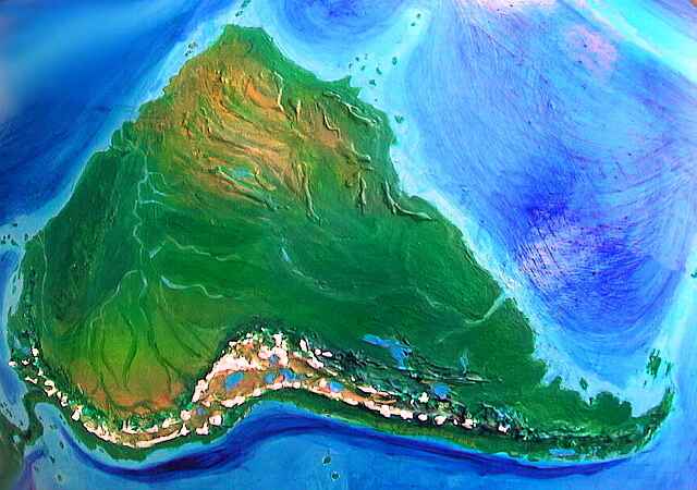
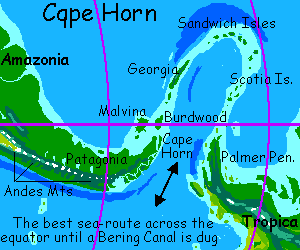
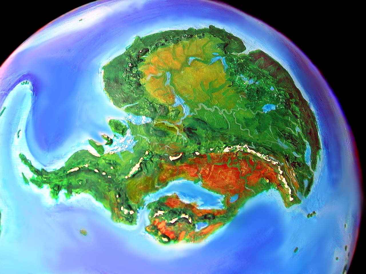
A thousand km east of Tierra del Fuego lies one last continent in the equatorial Jaredian strip--one so large it nearly completes the ring, stretching to within a few thousand km of Australia. "Circumnavigating" Jaredia is thus a deceptive phrase. "Circumambulating" would be fairer. Circle this Earth along the equatorial corridor, and you can walk 90% of the way. Still, this last continent we're approaching is the most isolated--Jaredia's great riddle, both biologically and culturally. Tropica is the logical name for this equatorial continent you know as Antarctica. Or rather you don't. None of us know this land--hidden under that ice-mantle is a sprawling, diverse, often spectacular continent.
In the west, the green, jagged Palmer Peninsula is Tropica's gateway: the great question is when the Patagonians will sail beyond the Malvinas and discover what lies beyond, or if native Tropicans will sail the other way.
Hmm. Part of Jaredia's game is for you to orient yourself without more than the world map--this is, after all, just Earth, tilted and changed a bit by falling sea levels and different climates. But most of us don't know Antarctica's geography or nomenclature any better than Mars... and the lack of ice is, in its way, as drastic a change as smothering Africa in ice--and I felt a map was justified there. All right! Just this once I'll give you a continental map...
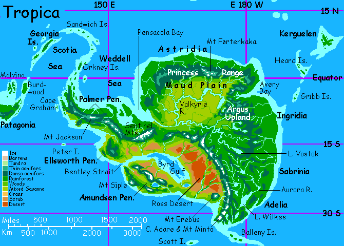
To the east is an immense savanna, drained by the great Valkyrie River. High mountains ring the plain, forcing most of the dense equatorial rains to fall on the coasts, the world's wettest. This lush strip, 1-500 km wide, is one of the world's ecological treasure houses. On the east coast, the strip widens; as the mountains curve inland, they spread to form a great tropical highland, the Argus Plateau, the size and height of Ethiopia, with a climate of perpetual spring. Coffee or tea, anyone?
In the southeast, the land is hilly, with many lakes. The rains turn seasonal here, and the western slopes of some ranges are grassland and scrub.
The Transtropic Range is a rugged dragon-spine dividing the continent, 4-5 km high--high enough for winter snow, even at this subtropical latitude. It stretches 3000 km from the Sentinel Range to the southeast coast. Standing apart is fuming Mt Erebus, the tall volcano standing alone, 3500 meters above the Ross Coast.
South of the Transtropics is the low, flat, red Ross Desert, one of the largest on Jaredia, broken by the many branches of the McMurdo River, fed by the Transtropic snows. To the west the desert slides quietly into the Byrd Gulf, over 1000 km long. The shallows of this warm sheltered sea are a coral paradise, but it's surprisingly deep in the center and west end near the Bentley Strait.
The great Amundsen Peninsula, (or is it an island? Or a cape linked to the mainland at the WEST end, not the east as I've shown it?) is dry along the coasts, but greener inland, where scattered ranges rise to 3-4000 meters. The land resembles the canyon country in the southwest US and northern Mexico, with redrock gorges and pine-clad plateaus. The lone peak on the south shore is snowcapped Mt Siple, three kilometers above the sea.
Astute viewers will note inconsistencies between versions of Antarctica in my alternate worlds--changes not fully accounted for by different sea levels. The soundings available to me, and the further uncertainty of true ground-level if you remove the heavy ice-burden, left me two choices: to pick one reasonable model for Antarctic landforms, and generate continents from that, based only on sea level and rebound effect... or to create each new version without reference to older ones. I chose the latter--if anything, I tried to make the variations as contradictory as I could, within what's known. I wanted to emphasize the uncertainty. If you saw similar mountains, river-drainages and coastlines, you'd gain a false sense of confidence. The only confidence I have is that if we had more accurate, detailed data, NONE of these coastlines, ranges or river basins would turn out to be right.
Still, regardless of its exact coastline, the utter isolation of Tropica would create a unique ecology--with unique primates. If they develop intelligence, and they might well, since the land resembles Africa, the resulting people might be hominids, or, as on Madagascar, they could well be descended from lemurs or tarsiers. Tailed or not? Furred or not? Diurnal like us, or big-eyed nocturnals? Omnivores or gorilloid herbivore? It's hard to say.
Fascinating though the possibility is, in a way I hope no such second species of people develops--for trapped in a smaller world, they'd probably advance more slowly than the mainland Jaredians, who I've set up, after all, to advance quickly. Once Jaredians discover the Tropicans, they'd be in for it--plague, slavery, war, oppression at best and extinction at worst.
Or is this narrow thinking? The Jaredians didn't evolve on our familiar African path either. Maybe the civilized Jaredians will be hairy, tailed vegetarians, and the Tropican species will be chimp-descended tough guys ready to kick some wimpy tailed ass. Our historical theories are all based on a single primate midway between bonobo and chimp, able to swing either way--cooperation or war. Within such a species, the tribe with better tools (and immune systems) usually spreads. But when it's different species, with different diets, instincts, and levels of aggression, then what happens? Does technology trump human nature when the nature's not quite human? All we know is that we don't know.
intro - map - Africa - Eurabia - India - Tibet - Java - Oceania - Siberia - Tortolia - Greenland - Amazonia - Tropica - Biology - culture - Randomia - lessons - roots
Jaredia is more fertile than our world. There are obvious losses--Africa, India--but millions of square kilometers miles of new coastal lands and islands (from the lower sea level), and the immense new tracts of fertile land in Siberia, Australia and Tropica more than balance this.
Further, the New World probably has richer fauna, even in areas where they are no greener. Consider: our oldest human-inhabited continent is Africa, and it has the most large animals. Second oldest is Eurasia, and it has the next richest megafauna--elephants, tigers, camels, ancestral horses. Australia, the next, has very little; but it's small and dry. Next come the Americas, a very large fertile land, yet they too have very few really large mammals. Bears, bison, moose... what else? The most recent human-settled lands, Madagascar and New Zealand, have no more large animals than Australia--we ate them all within a few generations. Jared Diamond has explored the reasons in "Guns, Germs, and Steel," but here, let's just say that exposure to earlier, less skilled hunters is like inoculation, and led to a higher survival rate--to coexistence. Jaredia's land-bridges guarantee early settlement worldwide--and thus, the early adaptation and survival of more large New World and Australian animals.
In some of my variant Earths, multiple species of intelligent life must share the Earth; or humans branch early into several species. This world, excepting Tropica, is much more uniform--racially, ecologically, and culturally.
Even in our world, with its extinctions and migration barriers, big-brained primates are scattered over a hemisphere--orangutans live in Indonesia. On Jaredia, with such easy migration corridors, prehumans will be worldwide, and whether people first evolve in Asia or the Americas, the new species will quickly fill the world, and races are less likely to develop. Though, of course, with African apes out of the picture, and tropical forest and savanna girdling Jaredia, "human" may have a different meaning, at least superficially. We may still be descended from apes of some sort, but other primates are possibilities--and not only primates. It's worth remembering that (even restricting the field to land animals) elephant brains are as complex as ours, while Arctic wolves have chimp-sized brains, and bears aren't far behind. Parrots and ravens have recently proven to rival apes in intelligence. Jaredia has a rich pool of big-brained creatures, the right environment to shape them, and plenty of time. If apes don't blunder into the right niche, other creatures will.
It's hard to say how much difference this would make. My guess is that even if some of the contenders started out herbivorous, they'd be omnivores soon after they developed fire and tools, for big brains burn a lot of fuel, and fat and protein are concentrated food sources. The only crucial difference between such people and us might be temperament. Aggression, territoriality, sociability, gender differentiation? And subtler traits: socially adept like bonobos or adept with tools like orangutans? The dominant sense may be sight, smell, touch or hearing. Such differences would shape history--but be taken for granted, essentially invisible. Don't we take our intraspecies aggression level, our tool-dexterity, and our smell-blindness for granted?
intro - map - Africa - Eurabia - India - Tibet - Java - Oceania - Siberia - Tortolia - Greenland - Amazonia - Tropica - biology - Culture - Randomia - lessons
With zones much like our Fertile Crescent in Bengal, Manchuria, California, and over short straits in Greenland, and Australia, there's a chance farming and herding would start far from our Mideast. But wherever it began, that convenient tropical corridor from Bali to Cape Horn would quickly spread domesticated plants and animals around the world. Tortolia and Amazonia will have a long head start over our Americas--tens of thousands of years at least, and possibly millions, if, as seems possible, one of them is humanity's cradle. Indeed there's every reason to treat Eurasia and the Americas as one supercontinent.
But the greatly increased fertility of Australia will also have cultural effects. In our world, Australia wasn't just held back by isolation; the total population was low and mostly poor; there was room for few innovators. On the eve of European invasion, Australia had only 300,000 people. Much smaller New Guinea had well over a million! But on Jaredia, the combined New Guinea-Australia is so large and rich it could sustain many millions. Enough to speed innovation? Certainly. The continent would be a cultural heavyweight, probably on a par with China or Siberia. Might there even be enough innovation so Australian ships would first explore the Pacific and Indian Oceans, exporting the Dreamtime to Zealand, Madagascar and (the big prize) Tropica? Australian temperate crops might do well on its south coast, and both continents have similar tropic zones too.
But Cape Horn's much closer to Tropica. It's deep water, no casual voyage, but if some Patagonian Columbus can sweet-talk a local queen into some funding...
Or would a New Zealander reach Tropica first, island-hopping along the Macquary-Balleny chain? In our world these isles are small, cold and little known, but on Jaredia, they're warm, fertile, larger, and more numerous. Fishermen might well discover the Tropican New World--and, probably, like the Basques, keep their mouths shut for centuries, as they quietly spread along the coasts.
Or... would Tropicans reach Zealand and Australia and Patagonia first? Could reverse colonization really happen? True, this sounds like Jaredian heresy. Society should progress much faster on the supercontinent (tailor-made for it, after all).
But if Tropicans evolve separately, from a different species, as would be likely, it could be millions of years earlier or later. They, unlike the Americans and Australians of our world, are totally decoupled from the rest of Jaredian evolution. A smaller land- and population-base might make their rise to civilization more leisurely, but Tropica is extremely diverse; they wouldn't lack for resources. If by chance Tropican people evolved first, they might well build deepsea vessels and settle the supercontinent while its natives are still chipping flint.
For more important than the factors speeding the rise of civilization, on a scale of thousands of years, are still-unexplored evolutionary pressures working on a scale of millions of years. And in the case of Tropica, they're working on a continent whose very coastline we aren't sure of! Tropica is an evolutionary wild card that could upset all Jaredian predictions.
intro - map - Africa - Eurabia - India - Tibet - Java - Oceania - Siberia - Tortolia - Greenland - Amazonia - Tropica - biology - culture - The Randomian Factor - lessons
"The grass always looks greener on the other side of the fence."
That old proverb isn't about jealousy, as most people think. It's subtler than that. You see, it's literally true. When you look at grass you stand on, you're looking down--you see the leaves end-on, so a lot of bare earth is visible too. When you look over the fence at your neighbor's grass, you see it full-length, at a low angle, so the grass-blades overlap and hide the ground. Even if your lawns are identical, your neighbor's grass really does look greener.
And this effect crops up in other places. Ever notice, on a busy, multi-lane road, how you always get stuck in the slowest lane? Lady Luck isn't out to get you--by definition the most crowded lane will have the most people in it! Clear, fast-moving lanes have fewer drivers. More often than not, you really ARE in a worse-than-average lane, the other lanes ARE greener--till you move over, and slow them up!
Now, the opposite principle applies to alternate earths. Consider:
Let's say you're contemplating Randomia, an alternate Earth no better or worse than ours, with roughly the same biomass, same amount of arable land, about the same population... just re-distributed. Now, what regions will you notice the most? First, your home, of course, and then, other well-known regions--and well-known means inhabited.
Randomia will always look worse! For, by definition, most readers will be from our world's high-population zones. Random changes will, on average, degrade them. And the lands that improve, that become the heartlands of Randomia's civilizations, are likely to be barren obscure lands in our world, mere names (if that) to non-Randomian readers. The Jaredian version of Europe is cold (millions of European readers groan), while the green Sahara nurtures great civilizations (a handful of Saharan readers cheer). If you love civilization, Randomia will probably stunt or kill the ones you love; its greatest civilizations will arise from lands (and creatures) you barely know and dismiss as primitive.
So the grass always looks browner in a parallel world--because what you value most, what you KNOW to value, is generally lost. This principle makes it hard to see alternate worlds fairly.
So, if I seem foolishly optimistic about these alternate Earths, postulating island leagues and tropical civilizations and intelligent lemurs or elephants or mega-ravens... just remember I'm fighting the Randomian factor. Your view is colored by the degradation of what you know and love; so my predictions of new growth and life in the unlikeliest regions, will seem fatuous. Yet they grow from the same data as the doom and gloom--your perceptions are naturally tilted toward seeing the losses. Factor Randomia in, before you mock.
intro - map - Africa - Eurabia - India - Tibet - Java - Oceania - Siberia - Tortolia - Greenland - Amazonia - Tropica - biology - culture - Randomia - Lessons Learned
The two big problems Jaredia posed for me weren't what I expected. I'd thought the thesis of "Guns, Germs and Steel" could be worked out in a sort of Petri dish--just add people and watch them grow! But people aren't added--they evolve from the system. And the factors speeding sapiogenesis (the evolution of intelligent life) are even worse understood than the factors speeding civilization. Since biological evolution comes first and takes longer, it injects huge uncertainties into the Petri dish--the race toward civilization is almost irrelevant, a mere ten or twenty thousand years. The million-year question is, do intelligent species develop at all, and if so, what, and how many, and where?
Damn.
The second problem is climatological. Wherever I can, I work by analogy, not theory or calculation. I look for similar latitudes and landforms and currents, figuring nature knows better than our simulations. But not all possible environments exist in our known world. So each alternate Earth poses questions that can't be answered by analogy. And Jaredia's a paradox! Its heavy northern icecap should create harsh weather in the temperate zones and drier tropics and subtropics, as our Ice Ages did. But Jaredia's long east-west coast allows an equatorial current to circle the Earth unimpeded. In eras when an equatorial ring-current flowed, our world was hot and wet, melting the ice even at the poles.
So which way does Jaredia swing? It's like a car with both the gas pedal and the brakes on--one pedal cooling and drying the northern hemisphere, the other pedal pumping enough heat to cause a global steambath! How do these forces balance out? I don't know. I've picked a middle path--a large icecap whose chilling, drying effects are largely hemmed in by warm currents just offshore. Only boreal forests are rare--the desert belt is small, and rainforests flourish, fed by storms from the warm ring-current. But you could convince me it could go either way--few rainforests, bigger deserts and savannas and steppes, even a northern dustbowl... or much less ice, rainforest in Mongolia, boreal forests in Africa...
Like the roots of sapiogenesis, the roots of global (not local) climate are not well enough known to predict the results when you postulate a situation far from the known.
In short, the climate of the equatorial strip I've built does indeed look uniform enough to speed the spread of early people, and then trade in domesticated plants and animals--fostering a worldwide rise of civilization, with fewer continental mass extinctions--cultural OR biological! But aside from warm and reasonably rainy, I'm not so sure just what that climate would be. Rainforest, encouraging fishing cultures and crops like taro or yams? Or drier, open forests, encouraging storable grains and seed-based agriculture? Or drier yet--mixed savanna, nomadic herders?
Similarly, I'm confident we'd see either one species with few races (at most, the cold-tolerant tribes of the African and European tundra might form a second race) or two species, one on the supercontinent, one on Tropica. But I have grave doubts these people would look or behave like us. They could be marsupials, dinosaurs, mini-elephants or giant raccoons.

Conclusions
Jared's theory is probably right--environment nurtures and limits technology, and the factors he describes make sense even applied to a very different geography. BUT... his theory has limits. It's only relevant when dealing with one intelligent species. For environment doesn't just shape but create people--and biology trumps culture! Civilization's rise can be sped or slowed by a wealth or shortage of domesticable species, but first you need enough potentially sapient species (plus poorly understood environmental factors, plus millions of years) before the Jaredian process can even begin.
I've done my best here--found that Jaredia's rich in warm, rugged, diverse regions with both wet and dry zones, like our East Africa--but while I think Jaredians of some sort are likely to evolve somewhere, logic takes me no further.
Maybe that's proper. In the end, civilization may arise from chance, a momentary inspiration, the legacy of kooks who play with fire, make up words, paddle toward the horizon. Before Jaredians, Randomians.
Maybe one day we'll try it--dare to be silly. And stumble into civilization.
NEXT?
I may soon take a short vacation from my game of tilt-the-axis. Instead, I plan to build our familiar world, with its axis un-tilted--but our world as it'll be if carbon dioxide stays high for a thousand years or so. Our current geography, but with CO2 at, say, 700 parts per million--enough to thaw Greenland and Antarctica completely. Once the world stabilizes, if it ever does, what'll it look like, that flooded greenhouse Earth we're so busily creating?
Drop by to check out Dubia, this doubtful world. No, I lied. It's really named in honor of the world's foremost advocate and producer of greenhouse gases--both via his oil/car policies and his hot-air speeches. George W. Bush.
Dubya.
Coming soon. And, I'm afraid, coming for real.
I'm a dream artist. But one with a scientific side. I always thought Jaredia, and Planetocopia in general, was my biggest nondream art project. Wrong! In 2020, while transcribing an old dream-journal, I found an entry dated 1990/3/31, thirteen years before Jaredia physically existed, detailing an almost identical art-globe project! "I took a globe off its stand, drilled new pole-holes to tilt the Earth so as to maximize fertility. The equator now runs through Tokyo, Alaska and Tierra del Fuego..." When I tilted a globe to see... the dream was unmistakably showing Jaredia, with poles and equator within a few hundred miles of their locations above.
Only now, THIRTY years after the dream, do I know that it was Planetocopia's seed. Just took a long time to sprout.
[Now it's 2022. I'm transcribing the very last of my dream-journals and came to 1987/8/15. Another Planecopia dream! In it, I found myself exploring a world with continents just like Earth but with its the poles shifted along a great circle. I found it fascinating how different the continents seemed. Unlike the 1990 dream, it specified no particular tilt, just explores the fundamental idea. But it's clear now my unconscious mulled this over for decades.]
World Dream Bank homepage - Art gallery - New stuff - Introductory sampler, best dreams, best art - On dreamwork - Books
Indexes: Subject - Author - Date - Names - Places - Art media/styles
Titles: A - B - C - D - E - F - G - H - IJ - KL - M - NO - PQ - R - Sa-Sk - Sl-Sz - T - UV - WXYZ
Email: wdreamb@yahoo.com - Catalog of art, books, CDs - Behind the Curtain: FAQs, bio, site map - Kindred sites