World Dream Bank
home -
add a dream -
newest -
art gallery -
sampler -
dreams by
title,
subject,
author,
date,
places,
names
GAZETTEER OF LYR
Q
A - B - C - D - E - F - G - H - I - J - K - L - M - N - O - P - Q - R - S - T - U - V - W - X - Y - Z
by Chris Wayan, 2006
Lyr (home) - map - creatures - cultures - evolution - climate - geology - gazetteer - nomenclature - definitions - building Lyr - more worlds? Planetocopia!
- FINDING ENTRIES: ignore words like "the", "Mt", "Cape"; Lake Urshi is under U, Sea of Fire under F.
- LARGE lands and seas are in CAPITALS.
- LONGITUDE on Lyr is always east, from 0 to 359. On the world map, 0 is in center, 90 center-right, 270 center-left, 180 at both edges.
- Quenna Is., 5-10 N, 300-330 E
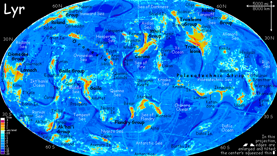
- A scattered flock of tropical islands in Oronesia south of Hrill. They're a key flyway between northern and southern hemispheres--from the western Quennas it's an easy flight to the Gaiila Cluster, gateway to the south, and the northeastern Quennas are a stepping stone to the Ayan Islands, bridge to the huge Ythri Region. The Quenna Rise is large and complex; it may be a continent under construction. Nightflier, largest of the Quennas, is fully 400 km across (250 mi); ten more rival Hawaii. The Fairwind Group in the north resembles Hawaii in climate; its larger isles have a wet east side and a dry west, while small, low islets tend to be dry. The central Nightflier Group, nearer to the equator, has monsoon forest even on dry sides and dense rainforest on the windward sides. The equatorial Hriccal Is are uniformly lush though small and low; many of these older volcanoes have eroded to mere seamounts capped with long slender coral islets. (Source: People of the Wind)
- QUENNA SEA, 10 N-20 S, 290-360 E
- A tropical ocean between Gaiila and the Flandry Cluster of continents. The southern boundary with the Nyanza Sea is hazy, but the Quenna Sea's about 100 million sq km (40 M sq mi, one-third larger than the Atlantic). A huge complex of twisting ridges in the northwest called the Quenna Rise suggest the Sea is being squeezed out of existence. Hundred of volcanoes on the Rise form the Quenna Archipelago, the Sea's only land. (Source: People of the Wind)
- QUETLAN, 2-6 S, 256-270 E
- An equatorial island 1600 km long and 900 wide (1000 by 550 mi) in the Gaiila Cluster. Quetlan's a heavily eroded shield volcano, now a low, complex mass of steep, dissected ridges; craggy Mt. Quetlan, 2300 m (7600') is the old volcanic plug. Quetlan's covered in dense rainforest; only the relatively dry Rokuro and Hikaru Peninsulas in the far south have any clearings. Here on the equator there are still two seasons--warm, rainy orbital winter (when Lyr's further from the sun) and hot, torrential orbital summer. The only difference is how MUCH heat and rain. (Source: People of the Wind)
- Quillipup, 7 S, 59-62 E
- One of the larger Kraoka Islands (Polesotechnic Strip), Quillipup is 830 km long and up to 500 wide (520 by 300 mi). Like Maui or Tahiti writ large, Quillipup is really two islands linked by lava flows; the western volcano, Mt Snarfon, is far smaller than Quillipup proper. (Source: A Sun Invisible)
A - B - C - D - E - F - G - H - I - J - K - L - M - N - O - P - Q - R - S - T - U - V - W - X - Y - Z

Gazetteer: index of places, with descriptions. Or...
TOUR LYR! Climb volcanoes, swim seas, meet weird creatures. First: survival tips! Then, pick a region:
Ythri -- Polesotechnic Chain -- Troisleons -- Roland -- Oronesia -- Gaiila -- Flandry -- Diomedes -- Ak'hai'i -- Averorn
Lyr's homepage - map - creatures - evolution - climate zones - geology and geography - gazetteer - nomenclature - definitions
LISTS AND LINKS: more worlds? PLANETOCOPIA! - dreams of other worlds - ecology - climate change - evolution - populations and eco-crashes - anarchy - utopias - natural disasters - terraforming - orbital dreams - sculptures and 3D art -
World Dream Bank homepage - Art gallery - New stuff - Introductory sampler, best dreams, best art - On dreamwork - Books
Indexes: Subject - Author - Date - Names - Places - Art media/styles
Titles: A - B - C - D - E - F - G - H - IJ - KL - M - NO - PQ - R - Sa-Sk - Sl-Sz - T - UV - WXYZ
Email: wdreamb@yahoo.com - Catalog of art, books, CDs - Behind the Curtain: FAQs, bio, site map - Kindred sites