World Dream Bank
home -
add a dream -
newest -
art gallery -
sampler -
dreams by
title,
subject,
author,
date,
places,
names
GAZETTEER OF LYR
Z
A - B - C - D - E - F - G - H - I - J - K - L - M - N - O - P - Q - R - S - T - U - V - W - X - Y - Z
by Chris Wayan, 2006
Lyr (home) - map - creatures - cultures - evolution - climate - geology - gazetteer - nomenclature - definitions - building Lyr - more worlds? Planetocopia!
- FINDING ENTRIES: ignore words like "the", "Mt", "Cape"; Lake Urshi is under U, Sea of Fire under F.
- LARGE lands and seas are in CAPITALS.
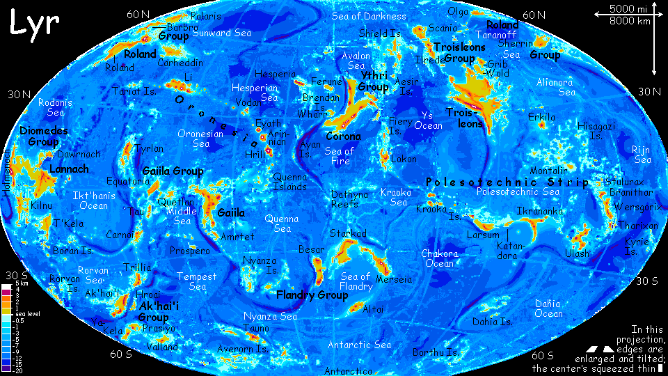
- LONGITUDE on Lyr is always east, from 0 to 359. On the world map, 0 is in center, 90 center-right, 270 center-left, 180 at both edges.
- Zatlach Desert, 15-20 S, 105-118 E
- The west coast of Ikrananka is one of Lyr's largest deserts--though by Earth standards, it's more a dry veldt than a true desert, greening at the ends to savanna and Mediterranean woods. Zatlach's a coastal strip only 200 km deep but nearly 3200 km (2000 mi) long. It's a biological hot spot: in a warm veldt with mountain-fed streams, winged migration wasn't needed, so evolution here favored big, nonflying grazers--and predators to match. (Source: The Trouble Twisters)
- Lake Zelo, Zelo I., 12 N, 2 E
- Largest lake on Lokon, in the Fiery Islands, Zelo is a lens shape 150 km (90 mi) long. Near its outflow is Zelo Island, the size of Manhattan; this speck is the largest freshwater island on Lyr, which has few large lakes. The lake's 1000 meters up, in a Mediterranean transition zone from savanna with "oak" groves to the cooler "pine" forests of the Evalyth Highlands. (Source: The Sharing of Flesh)
- Zeya River, 55-57 S, 15-20 E
- Largest river on Altai, in the southern Flandry Cluster. The Zeya Basin is a dark, chill evergreen forest along 1000 km of the east coast, running 500 km inland to the Bourtai Mts, broken only by Lake Rurik and subalpine meadows on the heights. (Source: A Message in Secret)
- Ziro Islands, 5-9 S, 257 E
- A north-south chain of islets linking Equatoria and Tau in the western Gaiila Cluster. Most are slender, low islets on the rims of coral atolls. The largest, Midway, is only 30 km long.(Source: Tau Zero)
- Zletovar Sea, 27-35 S, 7-15 E
- a tongue of the Flandry Ocean--a roundish sea 2000 km across, as deep as the Atlantic but shallow by Lyran standards. The Zletovar lies between Starkad and Merseia, the two largest continents in the Flandry cluster. A narrows, Ynvory Strait (created by the island of Ynvory) ends the sea. (Source: Ensign Flandry)
- Lake Zulei, 38 S, 184 E
- A shallow, oval lake 160 km (100 mi) in the center of Rorvan, and draining much of the island. (Source: Question and Answer)
- Zurian Is., 39-45 S, 300 E
- Ten islands in the Nyanza Archipelago (western Flandry Ocean). The Zurians are 1-200 km across (60-125 mi); gentle hills rising from shallow water, part of the Aquant Rise. They're temperate, rather like New Zealand: open forests and meadows. (Source: The Game of Glory)
A - B - C - D - E - F - G - H - I - J - K - L - M - N - O - P - Q - R - S - T - U - V - W - X - Y - Z

Gazetteer: index of places, with descriptions. Or...
TOUR LYR! Climb volcanoes, swim seas, meet weird creatures. First: survival tips! Then, pick a region:
Ythri -- Polesotechnic Chain -- Troisleons -- Roland -- Oronesia -- Gaiila -- Flandry -- Diomedes -- Ak'hai'i -- Averorn
Lyr's homepage - map - creatures - evolution - climate zones - geology and geography - gazetteer - nomenclature - definitions
LISTS AND LINKS: more worlds? PLANETOCOPIA! - dreams of other worlds - ecology - climate change - evolution - populations and eco-crashes - anarchy - utopias - natural disasters - terraforming - orbital dreams - sculptures and 3D art -
World Dream Bank homepage - Art gallery - New stuff - Introductory sampler, best dreams, best art - On dreamwork - Books
Indexes: Subject - Author - Date - Names - Places - Art media/styles
Titles: A - B - C - D - E - F - G - H - IJ - KL - M - NO - PQ - R - Sa-Sk - Sl-Sz - T - UV - WXYZ
Email: wdreamb@yahoo.com - Catalog of art, books, CDs - Behind the Curtain: FAQs, bio, site map - Kindred sites